An Inventory of the Historical Monuments in the County of Northamptonshire, Volume 2, Archaeological Sites in Central Northamptonshire. Originally published by Her Majesty's Stationery Office, London, 1979.
This free content was digitised by double rekeying. All rights reserved.
'Strixton', in An Inventory of the Historical Monuments in the County of Northamptonshire, Volume 2, Archaeological Sites in Central Northamptonshire, (London, 1979) pp. 138-142. British History Online https://www.british-history.ac.uk/rchme/northants/vol2/pp138-142 [accessed 23 April 2024]
In this section
54 STRIXTON
(OS 1:10000 a SP 86 SE, b SP 96 SW)
The small parish covers only 365 hectares between Wollaston and Bozeat and seems to be made up of lands formerly in those two parishes (see (7); Fig. 125). Most of the area is on flat land between 68 m. and 91 m. above OD. The underlying rocks are limestone and silts though in the S.E. these are overlaid by Boulder Clay. In the N. the land slopes steeply to the clay-floored valley of the Wollaston Brook which here forms the N. boundary of the parish. A number of Iron Age and Roman settlements are recorded, including (1) which has been partly excavated. The village of Strixton is now almost totally deserted, apparently as a result of the enclosure of the fields in the 17th century. The remaining earthworks are well preserved.
Prehistoric and Roman
A surface scatter of Iron Age pottery has been found in the extreme S.E. of the parish, close to the Bozeat boundary. This may be connected with the site to the S. (Bozeat (8); Beds. Arch. J., 3 (1966), 6). Roman pottery was found under ridge-and-furrow (at SP 900614; Beds. Arch. J., 3 (1966), 5).
a(1) Iron Age Enclosures and Ditched Trackway (SP 894619 and 894623; Fig. 124; Plate 1), W. of the village, on limestone at 68 m. above OD. Immediately N.E. of Hillmount Spinney air photographs (CUAP, BCJ 74–6 and in NMR) show a rectangular enclosure divided into two parts, with an entrance near the E. corner. Various ditches are visible within it and to the N. and S. Further N. there are more enclosures but the presence of frost-wedging in the soil makes interpretation difficult. N. of this there are traces of a ditched trackway. Excavations were carried out on the main enclosure in 1963 and 1967. A few features belonging to the pre-enclosure phase were discovered. The enclosure itself, which was of two main periods, was at first nearly square in form, but was later extended to the N.W. In the centre of the original enclosure were a semi-circular gully, perhaps of a contemporary hutcircle, and a number of post-holes and shallow depressions. The associated pottery was of late Iron Age type. Other finds included a penannular bronze ring and a clay loom-weight (Beds. Arch. J., 4 (1969), 1–12; 6 (1971), 18–19, BNFAS, 4 (1970), 32; 6 (1971), 17).
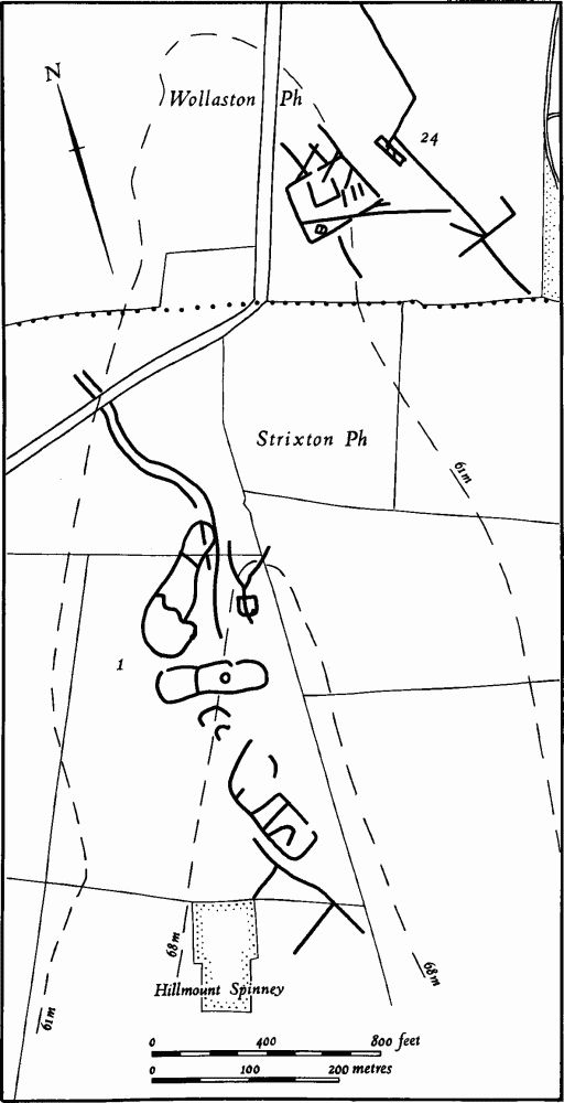
Fig. 124 Strixton (1) Iron Age settlement, Wollaston (24) Iron Age and Roman settlement
b(2) Iron Age Settlement (SP 901620), N.W. of the village, on clay at 60 m. above OD. An early Iron Age ditch and an area of occupation, marked by pebbles, were revealed in a pipeline trench (Beds. Arch. J., 7 (1972), 15).
a(3) Iron Age Settlement (SP 899607), in the S. part of the parish, on Boulder Clay at 65 m. above OD. Late Iron Age pits are recorded (Beds. Arch. J., 3 (1966), 5; OS Record Cards).
b(4) Iron Age Settlement (SP 900618), W. of the village, on limestone at 63 m. above OD. During trial excavations on the settlement remains (7) late Iron Age ditches containing pottery and antlers were discovered (Beds. Arch. J., 3 (1966), 6).
b(5) Iron Age Settlement (?) (SP 903605), in the S. of the parish, on Boulder Clay at 88 m. above OD. Iron Age pottery associated with a patch of charcoal is recorded (Beds. Arch. J., 3 (1966), 6).
b(6) Iron Age and Roman Settlement (?) (SP 907610), N.W. of Greenfield Lodge, on Boulder Clay at 83 m. above OD. A scatter of late Iron Age and Roman pottery, including samian, has been found (Beds. Arch. J., 3 (1966), 6).
Medieval and Later
b(7) Settlement Remains. (SP 902617; Figs. 125 and 126; Plate 20), formerly part of the village of Strixton, lie around the existing hamlet, on limestone and Boulder Clay at 72 m. above OD. The village is not listed separately in Domesday Book, and thus no record of the population exists for that time. However the first element of the name Strixton is almost certainly derived from the personal name Stric. In 1066 a person of this name held land in each of the adjacent villages of Wollaston and Bozeat. One or both of these manors may in fact be Strixton. The shape of Strixton parish in relation to the parishes of Wollaston and Bozeat suggests that Strixton has been made out of lands originally belonging to the other two parishes. It is thus possible that the Domesday entries under Wollaston and Bozeat referring to land formerly held by Stric were, at least in part, related to the settlement and land of Strixton. Adding together the recorded populations of the two entries gives a possible total of 18 people in Strixton in 1086. However the removal of the Bozeat entries for Stric from the other entries for Bozeat leaves a very small assessment for the rest of the parish and so the estimated population figure for Strixton can only be regarded as a maximum and is probably too great (VCH Northants., I (1902), 338, 347, 351, 353, 354; PN Northants., 197). The next record of the population of the village is not until 1377 when 37 people over the age of 14 are recorded as having paid Poll Tax (PRO, E179/ 254/14). On a map of 1583 (copy in NRO) 16 houses, including the manor house and the parsonage, are shown as well as six empty plots. By c. 1720, according to Bridges, only two houses, one of which was the manor house, still stood (J. Bridges, Hist. of Northants., II (1791), 198). He also said that before enclosure 'there appear to have been more houses'. On an 18th-century map of the parish (at Althorp House, c. 1765–88) four houses, as well as one outlying farmstead, are marked, and this may indicate the beginning of a repopulation. By 1801 there were 57 people living in the parish and by 1831 there were 69. On the Tithe Map of 1843 (NRO) a number of cottages are depicted in the area of the village, presumably of late 18th or early 19th-century date. Between 1843 and 1853 the village was rebuilt and a number of new cottages erected. By 1861 the parish contained 61 persons.

Fig. 125 Strixton (7) Parish boundaries
Much of the history and a very detailed description of the remaining earthworks has already been published (J. Northants. Mus. and Art Gall., 6 (1969), 22–32) and only the principal features are noted here (Fig. 126). The present main E.—W. street is lined by earthworks of various dates. N. of the street and E. of the church are the remains of the former manor house and gardens (8). To the W., between and behind the existing farms, are the remains of at least ten embanked closes, seven of which had houses in them in 1583. At the S. ends of five of them are the embanked or sunken areas marking the sites of former houses, three of which were already empty by 1583. To the S. of the main street and at the W. end extensive 19th-century quarrying has destroyed the remains of at least six houses which stood there in 1583 and the sites of three others which had already been abandoned by that date. Behind part of the quarry ('a' on Fig. 126) a group of rather battered ridges lay inside the closes of houses as shown on the map of 1583; the boundaries of the closes hardly survive except as hedge banks set in the earlier furrows. This situation, as at Walgrave (7) and Pytchley (8), suggests an extension of settlement on to former arable land. At the E. end of the street is a small area of low rectangular earthworks, the sites of buildings which had gone by 1583. An excavation here led to the discovery of a 13th-century dovecot. Part of this area was later ploughed with ridge-and-furrow. At its W. end the present street continues as a broad hollow-way. At the same point two other hollow-ways meet the street from the N. and S. (CUAP, BKZ 51–5, LS 84; MVRG, 19th Annual Report, (1971), 30–1; J. Northants. Mus. and Art Gall., 10 (1974), 38–58).
b(8) Site of Manor House and Garden Remains (SP 905616; Fig. 126; Plate 20), at the E. end of the present village street at its junction with the Wollaston—Bozeat road, on limestone at 76 m. above OD. The manor house stood immediately S.E. of the church, where a rectangular platform and some low banks mark its site. The W. half of the remains have been destroyed by a tennis court. The house is shown on a map of Strixton dated 1583 (copy in NRO) where it is depicted as a large building with a U-shaped plan, with a wing extending S.W. at an angle. During the late 16th or early 17th century an elaborate formal garden was constructed to the N. and E. of the house. Excavations on the site of the house have revealed continuous occupation from the early 14th century to at least the late 17th century, and Bridges noted that the manor still stood in about 1720 although the gardens had been abandoned (J. Bridges, Hist. of Northants., II (1791), 198). It is mentioned in a document of 1737 (NRO) but by the late 18th century it had been pulled down and the site had become an orchard (Map of c. 1765–88, Althorp House).

Fig. 126 Strixton (7) Settlement remains, (8) Site of manor house and gardens, (9) Windmill mound, (10) Cultivation remains
Remains of the garden still survive and are well preserved. N. of the site of the manor house there is a square sunken area, bounded by low scarps on three sides and by a bank on the N. It is crossed by slight traces of intersecting paths. To the E. is a long raised terrace wall which extends S. from the sunken garden to run along the side of the former house. Below it to the E. again is another part of the garden, partly bounded by terraces and banks, with an elaborate system of causeways, or limestone paths, visible in dry weather. In the N.E. corner and on the W. side are slight traces of later ridge-and-furrow over the abandoned garden (J. Northants. Mus. and Art Gall., 6 (1969), 22–34).
b(9) Windmill Mound (SP 90526135; Fig. 126), S.E. of the village in the S.E. corner of a field known as Mill Close in 1583 (Map, copy in NRO). It is now a plough-damaged circular mound, 30 m. in diam. and 1.25 m. high. Excavations on the site show that the original mill was erected in the mid 13th century, rebuilt in the late 13th or 14th century, and abandoned shortly afterwards (J. Northants. Mus. and Art Gall., 6 (1969), 29; 10 (1974), 38–58; MVRG, 19th Annual Report, (1971), 30–1; Beds. Arch. J., 8 (1973), 109–118).
(10) Cultivation Remains (Fig. 126). The common fields of the parish certainly existed in 1583 (Map of Strixton, copy in NRO) and were probably enclosed in the early 17th century. In 1619 Robert Parkhurst of London had licence to enclose 260 acres of arable land and convert it to pasture (VCH Northants., IV (1937), 55). By 1697 the lordship was described as 'closes of pasture or inclosed ground' (Records in NRO) and this is confirmed by Bridges in c. 1720 (J. Bridges, Hist. of Northants., II (1791), 196). This enclosure involved the establishment of large fields, many of which followed the boundaries of the former furlongs, and its final form is shown on a map of 1765–88 (in Althorp House). About this time these larger fields were broken up into smaller units. The details of the enclosure and of the surviving ridge-and-furrow have been published in some detail (J. Northants. Mus. and Art Gall., 6 (1969), 22–34; Beds. Arch. J., 7 (1972), 53–66).
Ridge-and-furrow of the common fields exists on the ground or can be traced on air photographs over much of the parish, including the area to the W. now in Wollaston parish. It agrees exactly with the pattern of lands and furlongs marked on the 1583 map. On the flatter ground in the centre of the parish it is arranged in interlocked rectangular furlongs, but on the steep valley sides on the E. and N.E. the furlongs are end-on with the ridges at right-angles to the contours. Where the ridge-and-furrow survives on the ground many features of minor interest have been recognised. Among these are well-marked rises or mounds at the ends of ridges, hedge banks of pre-1583 enclosures and paddocks of assumed 17th-century origin (e.g. 'b' on Fig. 126) and other features. Ridge-and-furrow is also visible among the remains of the former village (7) and the 17th-century garden remains (8). Some of this pre-dates the establishment of the village closes but the rest indicates late 17th-century or later ploughing (J. Northants. Mus. and Art Gall., op. cit.; F21 543/RAF/ 943, 0039–43; CPE/UK/1994, 1202–1198; CPE/UK/ 2546, 4137–41, 3136–8; F22 540/RAF/1312, 0292–6).