Survey of London: Volume 28, Brooke House, Hackney. Originally published by London County Council, London, 1960.
This free content was digitised by double rekeying. All rights reserved.
'Appendix: Nos. 1-7 Upper Clapton Road', in Survey of London: Volume 28, Brooke House, Hackney, (London, 1960) pp. 80-82. British History Online https://www.british-history.ac.uk/survey-london/vol28/pp80-82 [accessed 24 April 2024]
III. Nos. 1–7 (odd) Upper Clapton Road
formerly Nos. 1–4 (consec.) Brooke House Row or Terrace
These four houses were purchased by the London County Council with Brooke House in 1944 and demolished in 1957. (fn. 1) Two other houses which formerly stood at the south end of the terrace were demolished about 1855 for the laying-out of London (now Kenninghall) Road. (fn. 2) No record of their appearance survived but they were presumably identical with Nos. 1 and 3. Nos. 5 and 7, a pair, were built a little earlier than the other four, but all six were first occupied in 1760. (fn. 3)
They originally had three storeys above a semi-basement (though No. 7 had been enlarged by the addition of a garret) with, on each floor, one large room at the front and a smaller room and staircase at the back. Except in the case of No. 1, where a passage had presumably been formed, the front doors, reached by a flight of steps, opened directly into the front room of the raised ground floor. Nos. 1 and 3 had frontages of about 19 and Nos. 5 and 7 of about 23 feet, and in effect, formed two pairs of houses, with fronts of dissimilar design, faced with brown brick and finished at the top with a plain parapet having a narrow stone coping (fig. 19).
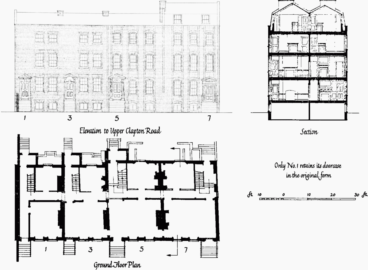
Fig. 19. Nos. 1–7 Upper Clapton Road
The more northerly pair were each three bays wide and had segmental-headed red gauged-brick arches over the windows, which were linked together into vertical panels by toothed red brick dressings. The party walls also were marked by a vertical band of toothed red brick, and there were toothed quoins at the northern end of the row. The doors, which fitted into the rhythm of the windows, were at the outer extremities of the pair, and were flanked by fluted Doric pilasters, above which the details had been altered and mutilated. The more northerly one had no fanlight, and the pilasters carried a disproportionately large entablature crowned by a pediment. The other, still more barbarous, had a semi-circular fanlight over the door, but lacked architrave and frieze, the bed moulds of the horizontal cornice of its pediment resting directly on the pilasters.
Each house of the more southerly pair had two square-headed windows with red gauged-brick arches on each floor, grouped closely together towards the northern end of its frontage, leaving a blank space to the south except on the ground floor, where the space was occupied by the front door in each case. The doorcases both had narrow ovolo-moulded architraves broken at the head by a large key block and planted on to margins which were plain except for simple base mouldings and neckings. The more southerly door had a full dentilled pediment, and the other, which showed signs of alteration, an open pediment.
Architecturally perhaps the most interesting thing about the terrace was the character of Nos. 5 and 7, which, on stylistic grounds could confidently have been dated between 1720 and 1730, had not documentary evidence existed to prove that they were actually built in 1755–60.
They were erected on a part of the Brooke House estate called Grove Close which was included in the lease from Lord Brooke to Thomas Pangbourne in 1750 (see page 64). In 1756 Pangbourne sublet Grove Close to John Slark of Hackney, carpenter, for 54¼ years from Christmas, 1755. (fn. 4) The bounds of this property can be traced on the 1868–72 Ordnance Survey map along the wall of Brooke House garden on the north, Nightingale Road on the west, and the southern frontage of London Road on the south. Excavations carried out about 1955 in Kenninghall Road along the southern pavement revealed a red brick foundation which was doubtless the southern boundary wall. (fn. 1) The eastern boundary of the property was a high wall facing the Stone Walk which lay on the site of the front gardens of the terrace. (fn. 4) During excavations traces of this wall were found about thirty-five feet back from, and parallel with, the frontage of Upper Clapton Road, but not parallel with the building line of the terrace. The area of the property leased to Slark measured about three acres; at its eastern end, near the road, stood a gardener's house, the only building mentioned.
Slark pulled down the gardener's house and began to erect two brick messuages, presumably Nos. 5 and 7. (fn. 5) He died in 1758, (fn. 6) probably before the completion of the two houses, which were not occupied until 1760. (fn. 3)
Slark's widow, Susannah, died in 1759 and named her friend Leonard Mittam of Clapton, bricklayer, as one of her executors. (fn. 7) He may have been Slark's business partner. Other associates of Slark may have been John Corbin of Allhallows, gentleman, William Cooke of St. Ethelburgh, blacksmith, and William Gill of St. Botolph, Bishopsgate, coach-painter, to whom Susannah Slark assigned her husband's lease in 1758. (fn. 5)
This assignment mentioned only the two houses built by Slark; the other four were erected between 1758 and 1760. (fn. 3) William Clarke's purchase of the head lease of the Brooke House property and his rebuilding of the front part of Brooke House (see page 64) may have stimulated the completion of the terrace.
At the beginning of the nineteenth century the two houses which were later pulled down to make way for London Road were made into one (fn. 3) and it was as five houses, not six, that the terrace was sold with Brooke House to Charles Monro in 1820 (see page 66). By 1904 the four remaining houses in the terrace had ceased to be occupied privately and were taken over by the owners of the asylum to house their staff. (fn. 8) Like Brooke House, they were vacated in 1940, and one of them was later used as a British Restaurant. They were demolished in 1957.