A History of the County of Oxford: Volume 1. Originally published by Victoria County History, London, 1939.
This free content was digitised by double rekeying. All rights reserved.
'Romano-British remains: Settlement sites', in A History of the County of Oxford: Volume 1, (London, 1939) pp. 281-303. British History Online https://www.british-history.ac.uk/vch/oxon/vol1/pp281-303 [accessed 19 April 2024]
In this section
C. Settlement-Sites
Only two settlement-sites of the Romano-British period in Oxfordshire, Alchester and Dorchester-on-Thames, have any claim to be called towns. The remainder were at best villages, and it is doubtful whether the majority even deserve that title, so scanty are their remains.
1. Towns
Alchester. (fn. 1)
The site lies 1½ miles south of Bicester and 11 miles NNE. of Oxford, in the area bounded on the SW. and south by the Chesterton brook, on the north by the Oxford-Bicester road and Langford Lane, and on the east by the railway. The site is low-lying, and the subsoil is gravel overlying the Oxford Clay. It is liable to floods in winter time, except where successive layers of habitation have raised the ground-level a few feet. Even during the dry summer of 1928 the investigation of the earliest Roman levels, barely 6 ft. below the surface, was hampered because they lay at or below water-level. There seems to be no reason to assume any considerable change in water-level since Roman times, (fn. 2) and we may ask, why did the Romans choose such a damp site for a town when there were good sites on higher ground some few hundred yards to the west or NW.? The answer seems to be that not only were there native settlements on this higher ground which the Romans wished to avoid— assuming, as we may (p. 285), that Alchester was a new Roman settlement— but also that the lie of the North-South Roman road dictated its position.
The main settlement (Fig. 19) (fn. 3) is almost a square. Its sides, each about 350 yds. long, were originally bounded by a rampart and ditch. The ditch is well preserved on the west only, where it still forms a field boundary; the rampart is easily discernible on the west and east, and less easily on the south, where the place of the ditch was taken by the Chesterton brook. On the north both the rampart and ditch have disappeared along the line of the road. Within the square two banks cross one another at right-angles, diametrically. One runs north and south, and occupies the line of the Roman road (p. 277) from Watling Street to Dorchester. It takes a curious and unexplained Z-bend near the southern rampart. The other runs west and east and continues outside the square eastwards, to the ford. Other subsidiary banks once existed within the town, (fn. 4) of which some in the SW. corner are still traceable, but those in the NE. have disappeared in subsequent ploughing. At two corners, NE. and SE., especially the latter, circular mounds are visible. The one at the NE. was proved in 1927–9 to contain the foundations of an internal corner-tower, and presumably the SE. mound is similar. If towers existed at the western corners, their traces have now disappeared, but Stukeley says (fn. 5) that 'the country people tell you in those places [i.e. the corners] were four towers to defend the city'.
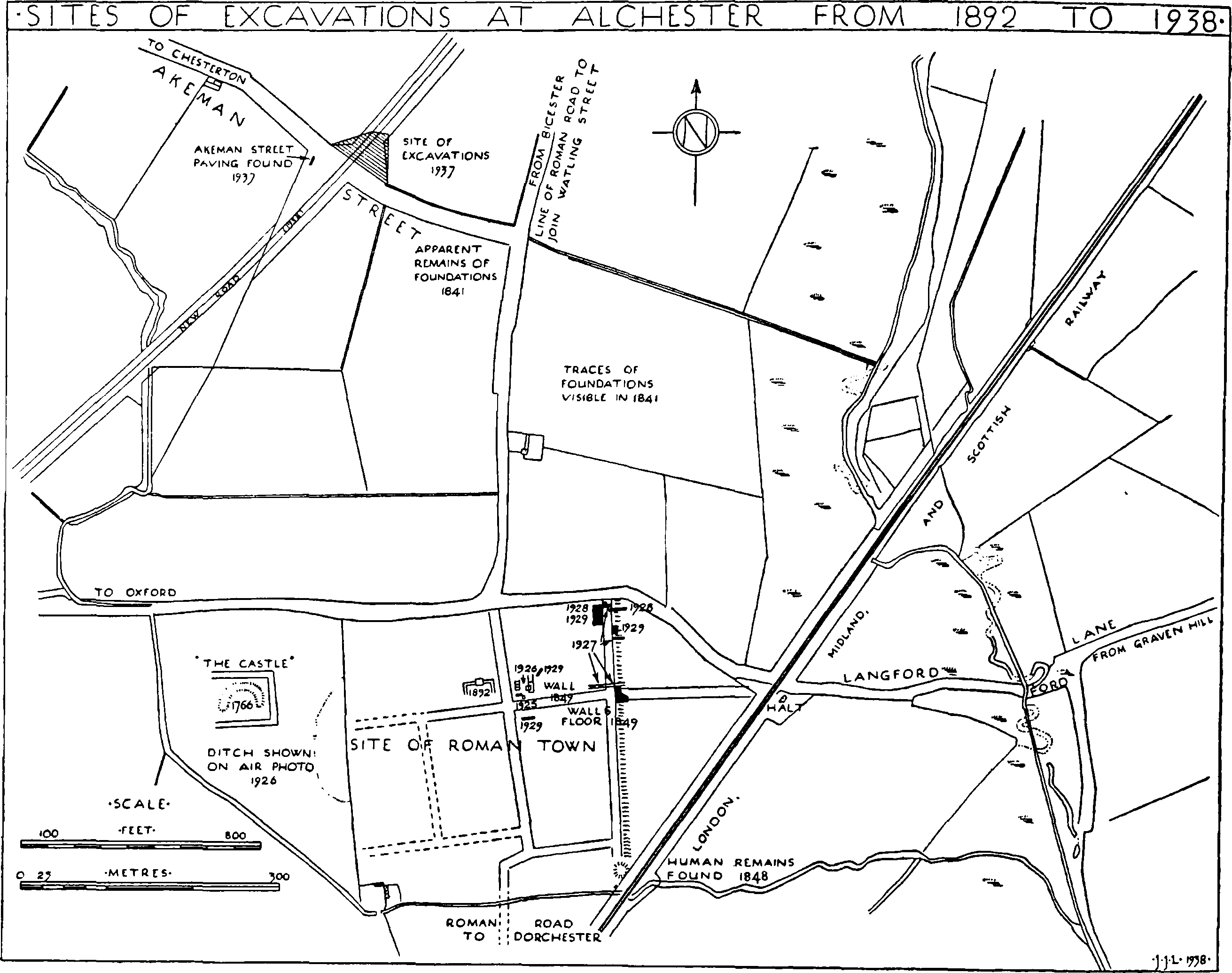
Fig. 19. Sketch-map of District round Alchester. (Based on the 25-in. O.S. maps with the sanction of the Controller of H.M. Stationery Office)
West of the main settlement, in the triangular field between the road and Chesterton brook, a mound marks the site of the building traditionally called the 'Castle', which Penrose's excavations proved to be a bath-house (p. 284).
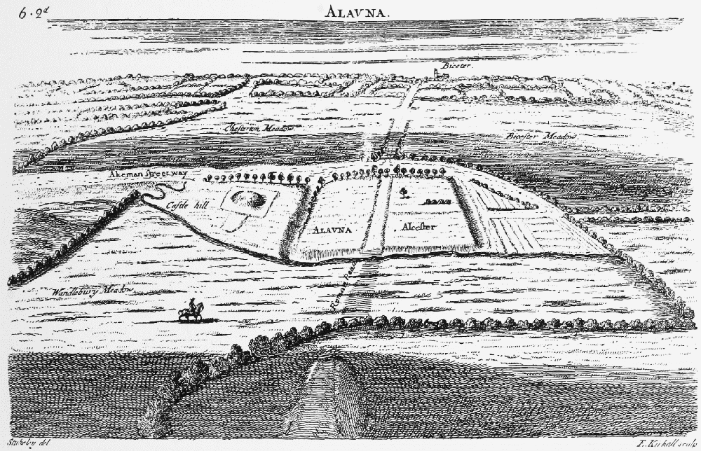
Fig. 20. Bird's-eye View of Alchester looking Northwards, by W. Stukeley. (After Stukeley, It. Cur. (1776), ii, pl. vi between pp. 40–1)
The traces of buildings that Stukeley mentions in the meadows north of the main settlement cannot now be seen. Similarly, in the fields to the north, where Brown marks 'ground raised and irregular', such irregularities have mostly disappeared. An air-photograph taken by the O.S. in 1926 (fn. 6) revealed the plan of a rectangular building SE. of the town, across the railway line, and Romano-British sherds can be picked up in most of the neighbouring fields.
In the field forming the NW. angle between Chesterton Lane and the OxfordBicester road excavation (fn. 7) in 1937 revealed a late Iron Age and RomanoBritish habitation-site dating from the 1st and 2nd centuries; and it was here, too, that a decorated Arretine fragment (Pl. XIII, a) was found by Mr. C. L. Stainer many years ago. (fn. 8)
The first notice of the site in literature appears to be Camden's brief reference: (fn. 9) '. . . adiacent desertae stationis paucae reliquiae, Alchester vocant . . .,' from which we can infer that, three centuries ago, there was little more to be seen on the site in the way of ruins than there is to-day. Stukeley's engraving of one hundred years later (Fig. 20) tells the same tale, for it only marks the still existing banks of the town itself, the Castle mound, and the Roman roads in the neighbourhood.
Shortly after Camden, an anonymous historiographer wrote a fanciful history of the site, (fn. 10) but it is Stukeley, (fn. 11) writing in 1724, who first gives a detailed description of the place:
'This city was fenc'd with a bank and ditch quite round. 'tis a square of 1000 foot each side standing upon the four cardinal points. the vallum and ditch are sufficiently visibl, tho' both have met with equal change. the vallum from the plow which levels it to a certain quantity every year, and the inundation of the meadow raises the ditch. these are most easily discernibl at the corners, for there they are still pretty perfect and so notoriously, that the country people tell you in those places were four towers to defend the city . . . . great foundations are known to be all around in the meadows especially northward and eastward upon both sides the Akeman. on the west side of the city a little distance from the ditch is an artificial hill in the very middle of the meadow which they call the Castle hill, and is full of Roman bricks, stone and foundations. I attentively consider'd this place. the circuit of it is very plain and defineabl, 'twas a square of 200 foot. . . . the edg of the area is very distinct upon the medow by the difference in the color of the grass, the one gray the other green, but the main body of the building reach'd not so far, but lyes in a great heap of rubbish much elevated and of much less extent. before it to the south has been another area pav'd with a bed of gravel at least, above 100 foot broad. I doubt not but a curious person that will be at the expence of digging this plot would find it well worth his while.'
Excavations in the 'Castle' were shortly afterwards (1766) undertaken by Mr. Penrose, (fn. 12) who owned the site. He found remains of a considerable wall with a central doorway, running apparently north to south on the east side of the mound. West of this wall, i.e. within the building, was a room with a tessellated pavement, and north of it, 1½ ft. lower, a hypocaust floor with pillars. This is enough to show that the so-called Castle was a bath. About 1800 most of the stone remains of this building were removed for road-making. (fn. 13)
Modern investigations begin with the researches of Hussey and Brown in the middle of the 19th century. Hussey thought, (fn. 14) arguing from the sundry signs of foundations, &c., noticed by Brown and others in the meadows north and east of Alchester, that the town itself was a camp, with uninclosed civil settlements around it. He even suggests that there may have been one as far away as Chesterton.
Brown made several exploratory excavations, (fn. 15) the chief being in 1850, when he found a walled porticus in the NW. angle of the main cross-streets: (fn. 16) this is probably the same building excavated by Manning and Myres in 1892. (fn. 17) He also mentions Roman remains found east of Alchester in building the railway line in 1848; (fn. 18) a cemetery of twenty-eight skeletons was discovered at the same time just outside the SE. corner of the town. (fn. 19) In 1850 and 1856 objects from Alchester were shown at meetings of the British Archaeological Association in London. They included Samian and other pottery, some stamped with makers' names, fragments of glass, a head of Diana in white clay, and other small objects. (fn. 20)
In 1892 (fn. 21) J. L. Myres and Percy Manning proved that the defences on the east side of the town 'consisted of a bank of gravel, faced with rubble'. At the NW. angle of the main cross-streets they found 'foundations of walls bounding three sides of a court', which court appeared 'to be open to the south, and to be surrounded on the other sides by a corridor, interrupted in the middle of the north side by a rectangular chamber'. The coins ranged from Drusus the Elder (fn. 22) to Honorius. In 1925 trial trenches were made through the east rampart and near the centre of the town; (fn. 23) and excavations during the four following years have made it possible to outline the town's history. (fn. 24)
The absence of pre-Claudian pottery on the site is strong evidence that Alchester was not founded before the Roman army reached Oxfordshire. A coin of Tiberius (fn. 25) and a republican denarius of Piso Frugi found in 1910 (fn. 26) are quite likely to be survivals brought in by Romans and lost many years after minting.
Each successive campaign of excavation has made it more certain that the guesses of early antiquaries (fn. 27) were right and that Alchester was one of the earliest Roman foundations in Britain. If, as Collingwood suggests, (fn. 28) the Fosse Way had become the frontier line as early as a.d. 47, there must have been some semi-civil depots for the armies not far behind the fighting line: and Alchester, placed at the junction of two Roman roads, is a natural site for such a depot. It was probably never a military post: such was not needed in the quickly pacified Dobunian territory; we must think of it rather as a commercial centre for providing and controlling the commissariat of the frontier forces.
In 1926 a section was taken across the north-to-south street and its side ditches. (fn. 29) The street surface was 15 ft. wide and was bounded on each side by a steeply cambered slope leading to a V-shaped ditch (Fig. 22). This street was probably laid out in the Claudian period or shortly after, for pre-Flavian pottery (Pl. XIII, b, and Fig. 21) was found in the bottom of one of the ditches; (fn. 30) this is important, not only for the history of Alchester, but also for that of the road to Dorchester, as is pointed out elsewhere (p. 296). In 1927 a trench driven across the eastern edge of the town (fn. 31) revealed what was then thought to be an early defensive system inside the main ramparts, consisting of a gravel and clay bank behind two parallel ditches 2½ ft. apart. But the subsequent discovery of similar ditches 20 ft. apart at the NE. corner (fn. 32) and of another ditch running into these (fn. 33) makes it clear that these ditches were only drainageworks, and we may assume that the first rampart is the gravel one, about 22– 25 ft. wide, which lay immediately outside the stone rampart-wall, and of which a section was taken in 1928 (fn. 34) (Figs. 23–4). The ditch, 15 ft. wide and about 2 ft. deep, outside, and belonging to, this rampart yielded native and Samian pottery of mid-1st-century date.
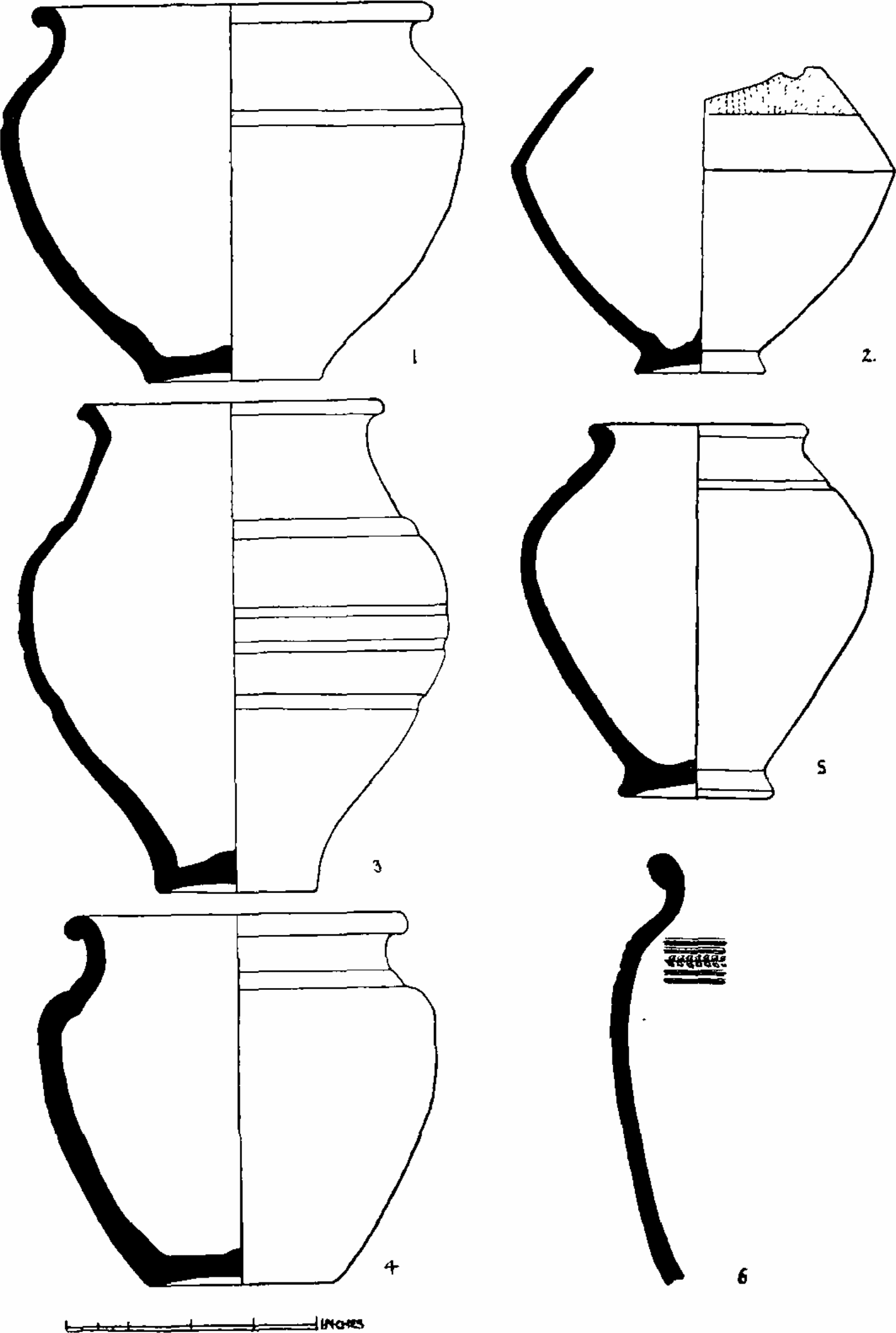
Fig. 21. Mid-First Century Pottery from Alchester. (After Antiq. Journ. vii, 177, fig. 8)
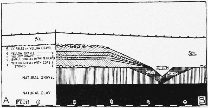
Fig. 22. Section of Street near Central Cross-roads. (After Antiq. Journ. vii, 161, fig. 3)
It appears, therefore, that Alchester was founded about the middle of the 1st century a.d. and was enclosed by a gravel rampart and a ditch. Since remains of wattle-and-daub, (fn. 35) but no stone foundations, have been found in the earliest levels, it must be assumed that the town was composed of timber buildings and wattle-and-daub huts. The post-holes and sleeper-beam trenches that would be visible on a drier site were obliterated in the damp conditions at Alchester. About the turn of the century the wooden houses were replaced by stone-built houses and the gravel rampart backed by a stone rampart-wall. Stone buildings of this age have been found in the NW. (fn. 36) and NE. (fn. 37) angles of the central cross-streets, and also inside the NE. corner. (fn. 38) The stone rampartwall was reinforced, presumably at each corner, by an internal tower of stone. The foundations of that at the NE. were examined in 1927–8, but were very fragmentary, (fn. 39) and its plan could not be ascertained. On the north side of the east gate foundations of what may have been an internal angle-turret built of concrete were found in 1927, (fn. 40) but the remains were not completely uncovered and this interpretation of them is not certain. The stone rampart-wall itself was about 9 ft. wide in its foundation-courses, (fn. 41) the stones of which were set on edge and slightly tilted. Nothing but foundations remained except for one or two roughly squared single stones laid horizontally in cement upon them. That all these works date from the time of Hadrian is suggested by the pottery found in the buildings in the centre of the town, (fn. 42) and in the stratum between the foundations of the NE. corner-tower and the underlying 1st-century ditches. (fn. 43)
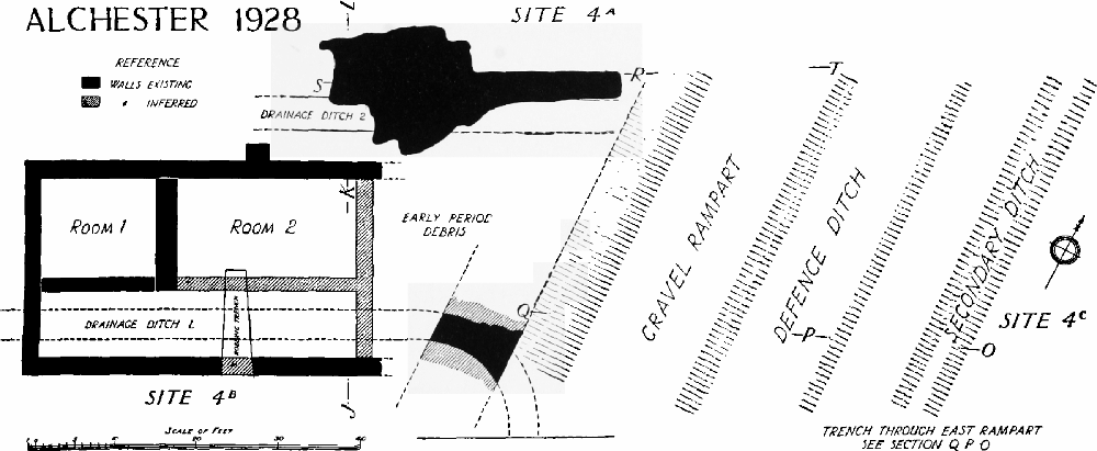
Fig. 23. Plan of Excavations in NE. Corner of the Town, 1928. (After Antiq. Journ. xii, 37, fig. 1.) The evidence for the existence of the 'secondary ditch' was very slight (op. cit., p. 48)
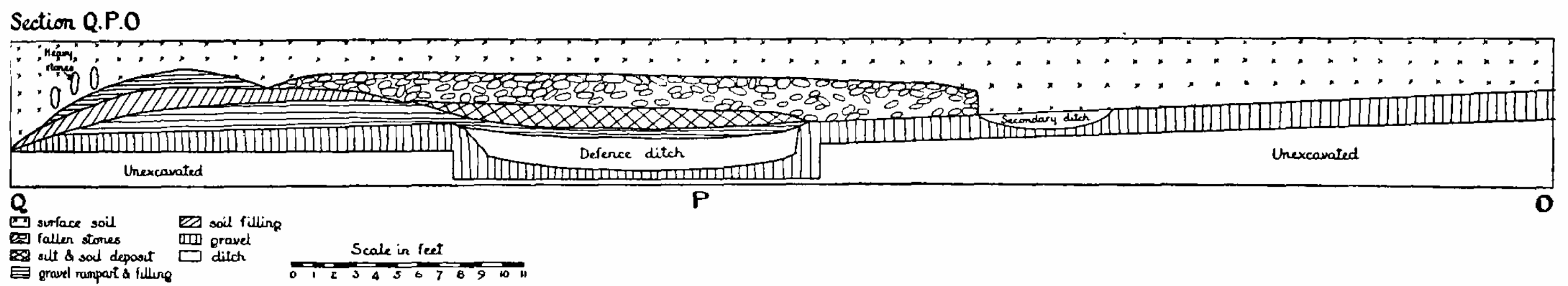
Fig. 24. Section through Defences of Roman Alchester. (After Antiq. Journ. xii, 39, fig. 26)
After Hadrian's time no drastic refashioning of the defences seems to have taken place, but it has to be remembered that the latest strata of occupation come so near to the modern surface that evidence of changes might have been obliterated by post-Roman disturbances. It is clear (fn. 44) that there was much rebuilding and replanning of the houses during the late 2nd and 3rd centuries as the occupation-levels rose, and that the streets were remetalled at higher levels more than once. To judge from the evidence of coins and pottery, there can have been no diminution of the intensity of occupation up to the end of the 4th century, yet no considerable house-foundations of this late period are known: later ploughing, when the site formed part of the common fields of Wendlebury, has taken its full toll of these. Road-metalling of this period was laid bare in 1927 (fn. 45) at the junction of the east to west street with the street which skirted the east wall on the inside.
The latest coins at Alchester—as at most other habitation-sites in Oxfordshire—are those of Honorius and Arcadius. Since the barbarous imitations of Roman coins current in Britain in the 5th century are absent, we may assume that Alchester was soon abandoned after the official departure of the Roman arms. That its buildings were robbed by Bishop Birinus in the 7th century to provide building-stone for his new foundation of 'Birincester' has now become an integral part of antiquarian tradition. (fn. 46) Unhappily, there is neither historical nor philological basis for the connexion of Birinus with Bicester, although we may readily believe that whoever built the new town would quarry the ruins of the old.
The history of Dorchester (p. 296) was very similar to that of Alchester. Both towns, and the road connecting them, appear to have been founded on a concerted plan during the early years of the Roman occupation; both were fortified with stone ramparts during the early years of the second century; and each remained throughout the Roman period a small market town at an important traffic-junction, the one where Akeman Street crossed the NorthSouth Road, the other where the latter road crossed the Thames, the principal water-way of Britain. That Alchester was deserted after the Romans left, whereas Dorchester lived on to attain its peak of prosperity during the early Middle Ages, is easily explicable. The site of Alchester is low-lying and wet, and the town had no chance of survival once the Roman road upon which it lay fell into disuse: the site of Dorchester is altogether more advantageous, and, situated as it is at the confluence of the Thames and Thame, has a permanent geographical importance.
Dorchester-on-Thames. (fn. 47)
The modern village, situated west of the River Thame about half a mile above its confluence with the Thames, occupies roughly the same position as the Roman settlement (p. 290). In late Saxon and early Norman times the town of Dorchester, having become a bishop's see, extended over a much larger though somewhat undefinable area; but as soon as the see was removed in 1085 to Lincoln, the town began to dwindle, so that by Leland's time (1542) it was nothing more than the village that it is to-day.
The Roman town, whose Latin name is unrecorded, (fn. 48) occupied, if the account of the ramparts recently published (fn. 49) is correct, an area of some 13½ acres (Fig. 26). It was therefore but half the size of Alchester and was only large enough to contain some few hundred inhabitants. There were, however, considerable settlements outside the ramparts, as is proved by finds of coins and small antiquities in the fields on all sides of the town.
A quarter of a mile south of Dorchester (Frontispiece) are two parallel banks known as the Dyke Hills, which inclose and defend the promontory between the Thames and Thame. Early antiquaries spent much labour in arguing for and against a Roman origin for these banks. (fn. 50) Even J. H. Parker, (fn. 51) as late as 1882, thought the enclosure was the camp of Aulus Plautius, though Barns (fn. 52) argued that it was pre-Roman, as Hussey (fn. 53) and Lane-Fox (Pitt-Rivers) (fn. 54) had done previously. The truth of this last contention no longer needs demonstration, for such promontory forts are now well known (pp. 252, 259) to be a British and not a Roman type of settlement. Only excavation could prove how long the pit-dwellings (fn. 55) of the Dyke Hills settlement continued in use after the Roman conquest.
Many antiquaries, beginning with Leland, have something to say of Dorchester as a Roman town, but the only three who give it more than a passing reference before the middle of the 19th century are Hearne, Gough, and Skelton. All three confine themselves mostly to notices of small finds. (fn. 56) In 1882, when J. H. Parker wrote his History of Dorchester, the total knowledge available was meagre, but the section of Barns's letter which deals with the Roman period provides some valuable topographical details. This has now been superseded by the field survey and excavations successfully accomplished by members of the Oxford University Archaeological Society in 1935–6, (fn. 57) which must form the basis of any future account of the site.
The evidence about the Roman town and its history will be treated under three heads: A. Topography, B. Small Finds, C. History.
A. Topography.
The excavations of 1935–6 were undertaken with the purpose of providing a cross-section through the defences on the western side of the town. It was not possible to do this in one trench, owing to the incidence of out-buildings, fruit-trees, and other obstructions, but by means of three trenches (fn. 58) results were obtained, which are illustrated by the composite diagram, Fig. 25.
The outer ditch proved to be about 50 ft. wide and 5 ft. deep. The inner ditch was about 15 ft. wide and 4ft. deep. The mollusca found in these two ditches (fn. 59) showed that both were permanently wet; the outer contained about 3 ft. or 4 ft. of water and may have had a connexion with the Thame; the inner ditch had less water and was overgrown with reeds.
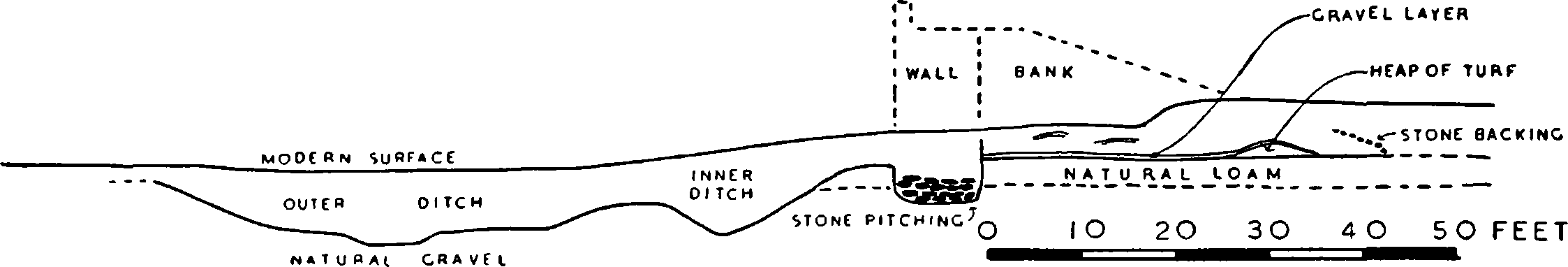
Fig. 25. Composite Section Through Western Ditches and Rampart, Dorchester. (After Oxoniensia, ii, fig. 13)
The wall, which was separated from the inner ditch by a small berm of about 6 ft., had been almost entirely robbed in later ages, but enough of the footings was discovered to show that it was about 9 ft. thick at the base and sunk 2 ft. 6 in. into natural gravel. Behind the wall in section C were traces of the lower 2 ft. of a supporting bank faced with stone pitching. This bank was 43 ft. wide at the bottom and sloped up gradually towards the top of the wall, which was probably at least 15 ft. high.
A pit thought to have been dug after the erection of the wall (section B) and a pre-rampart occupation-ditch in section C yielded sufficient stratified pottery to date the construction of this system of ramparts to about a.d. 125 or a little later. They remained in use, at least intermittently, until the 12th century, and the evidence of stratified potsherds in the filling suggests that the outer ditch was carefully cleaned out both in the 3rd or 4th century and in the 11th or 12th.
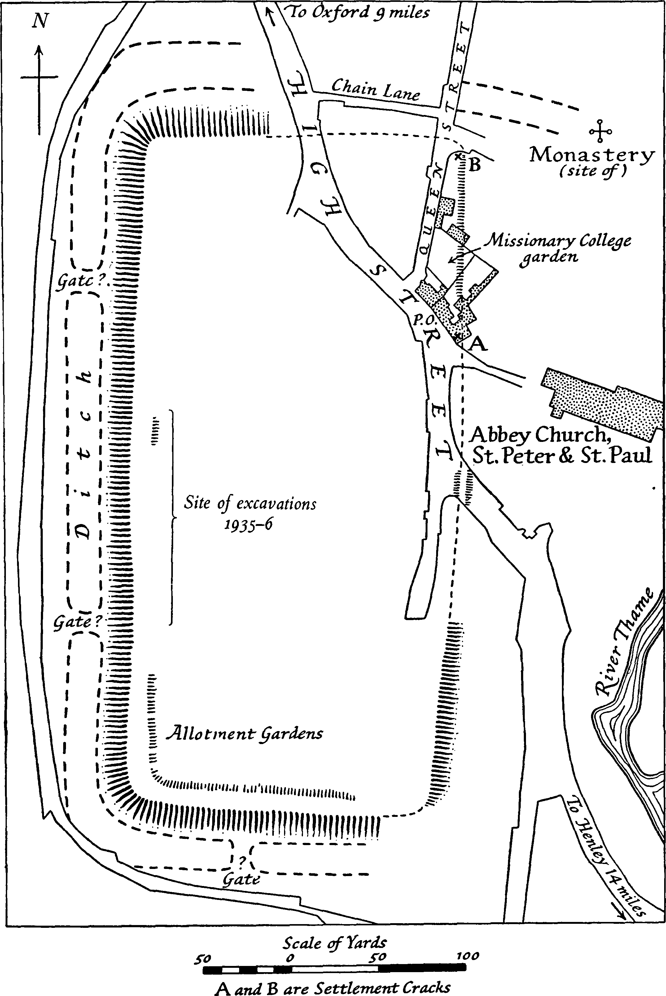
Fig. 26. Plan of Roman Defences, Dorchester. (After Antiquity, ix, 218.) Based on the 25-in. O.S. map with the sanction of the Controller of H.M. Stationery Office
These ramparts formed roughly a rectangle of 13½ acres (Fig. 26), 375 yards long by 175 yards wide. The NW., SW., and SE. sectors are clearly recognizable from surface indications and it is only at the NE. that any doubt exists as to the approximate line they took. After the modern road from Oxford has entered the outskirts of the village, it comes to a fork. The left-hand branch forms the High Street of Dorchester: the right-hand branch moves SW. for about 200 yards and then turns south, straight along the western edge of the village. Having reached the SW. corner, it bends at rightangles round the allotments and runs east in a tortuous course. (fn. 60) The NW. corner of the Roman vallum can be traced as a slight rise a few yards east of where this lane changes direction from SW. to south. The western ramparts run from here due south, slightly east of the modern lane, and are plainly visible running through gardens and orchards. In the middle of the allotments (Hemp Croft) the SW. angle of the vallum is plain, and its south side runs due east until it picks up the line of the front gardens of Albert Place. These are on a rise, supported by a stone wall, and the sudden change of level must be attributed to the Roman vallum and its accompanying ditch. The SE. corner of the ramparts must have lain under the east end of this terrace, for north of this point the east vallum is visible behind the Castle public-house, running parallel to the High Street. Farther north is a ridge in the same alignment crossing the High Street near the SW. angle of the churchyard, and beyond this, two settlement-cracks in modern masonry (A and B on the plan, Fig. 26) with a faint ridge in the intervening gardens seem to mark its course. The NE. angle is not traceable, but it must have lain at B on the plan, where the drive from the Vicarage and Manor House joins Queen Street. Thence the line of the north vallum took a direct course parallel with and south of Chain Lane, across the High Street, to the NW. angle.
The ditch outside the north vallum is not visible now, but it occupied roughly the line of Chain Lane, and Barns (fn. 61) saw it 'very conspicuous at the junction of Chain-lane with High-street'. Along the western and southern sides of the town a broad though slight hollow represents the outer ditch of the defences. Outside the eastern vallum no trace of a ditch can be seen. If a ditch originally existed here it must have been filled up later when the town was enlarged, for the monastery and castle stood outside it along the banks of the Thame, partly on a raised platform. (fn. 62) There is some evidence (fn. 63) that both the southern and northern ditches extended direct from the SE. and NE. angles of the town to the River Thame, the former under the Roman Catholic Church, the latter under the Manor House. As both the outer and inner ditches were wet, at least one such extension must have existed, but even if both the north and south branches had been made they would hardly have been accepted in full substitution for a ditch along the eastern rampart. Such a layout would make Dorchester unique amongst Romano-British towns, and far stronger evidence is required than mere surface-indications.
We cannot at present fix the position of the gates of Roman Dorchester and the course of the Roman road through the town. The plan (Fig. 26) shows two causeways on the west side and one on the south, interrupting the ditch. Only excavation could decide whether these marked the sites of gates, though they are in the right places: those on the west are at equal distances from the NW. and SW. angle respectively, and that on the south is almost centrally placed. If there was a gate on the north side corresponding to that suggested on the south it would have been slightly to the west of where the High Street crosses the north rampart, and in true alignment with the road from Alchester. There is no reason to assume (fn. 64) that the road did not keep this alignment and run straight through the centre of the town as it did at Alchester. As both towns and their connecting road seem to have been laid out contemporaneously as part of a concerted plan, it is probable that the layout of the two was, in such an essential, the same. Its line after leaving the town on the south is not certain. If the ford between Dorchester and Shillingford (p. 278) was the only passage across the Thames, the road must have taken a right-angled bend eastward to cross the Thame at or near the spot where the medieval bridge stood, and so join the line of the modern Dorchester–Benson road. But if there was an alternative ford at the confluence of the rivers it may have kept its direct course southward.
Not a trace of any public building of Roman date has yet come to light at Dorchester. (fn. 65)
B. Small Finds.
The small finds, apart from those discovered during the O.U.A.S. excavations in 1935–6, (fn. 66) are all chance discoveries, and are best listed in categories. With the exception of such outstanding examples as the Broome Park altar, the Vicarage Garden cremation-group, and the 4th-century silver spoons, they are of very secondary importance.
Foundations of buildings, tessellated pavements, &c.
(a) In the cellar of a house on the west side of High Street, opposite the churchyard—a tessellated pavement; Taunt, Dorchester Guide, 3; O.S. 6 in. A note in O.S. Namebook says 'some Roman tesselated pavement was dug up here a few years ago by Mr. Cobb'.
(b) In Hemp Croft (allotments, SW. corner of village)—bricks and numerous coins; B.B.O.J. iv, 80–coins; Gough's Camden (1806), ii, 28; O.S. 6 in.–tessellated pavement; Taunt, Dorchester Guide, 3.
(c) Near the Thames, west of Bishop's Court–rubbish-pits and one tessera; B.B.O.J. iv, 80.
(d) Beneath NE. chapel of the Abbey, 12 ft. below surface–'Roman' pavement, underneath which was burnt corn and bones; Oxf. Times, 4 June 1886; B.B.O.J. iv, 80 (but 'S.E. chapel' and no pavement, only 'charred corn'). Some charred remains (? wood) from this find are preserved in the Ashmolean. It should be mentioned that the thin red tiles visible in the interior wall of the Abbey opposite the south door, which are sometimes claimed as Roman (v. Kirkpatrick, Dorchester-onThame, p. 9), are certainly medieval or later.
(e) Manor Farm yard–cemented cistern and fragments of several urns; B.B.O.J. iv, 80.
(f) Dorchester Farm Field (Minchin Recreation Ground)–R.-B. homestead (?), many intersecting ditches on air-photograph; B.B.O.J. iv, 78; Antiquity, i, 472 ff. and pl. ii.
(g) Below Sinodun Hill (i.e. on Berkshire side?)—several Roman buildings and coins; Hearne, Roper's More (1716), 258.
(h) No exact location—tessellated pavements; Gough's Camden (1806), ii, 28; Brewer, Topog. of Oxfordshire, 374.
Pottery and habitation-refuse.
(a) In the garden of Town House, c. 1874, 7 ft.-8 ft. below surface—great quantity of pottery and numerous coins, formerly ap. Wm. Cobb, builder, Dorchester; B.B.O.J. iv, 80; (?) Ash. Mus. 1886. 1644.
(b) Below foundations of malt-house, Jordan's Lane, 1886–bronze antefix in form of a female bust, H. 3¼ in., bronze ear-ring (? medieval) and a large quantity of bones and potsherds; Ash. Mus. 1886.799 a, b; B.B.O.J. iv, 80.
(c) In the churchyard, 5 ft. below surface—Samian dish (Drag. 79); Ash. Mus. 1886. 1617 (formerly Wm. Cobb Coll.).
(d) At Flixécourt, east side of High Street, opposite the western lane, 1934, behind garage, 4 ft.-7 ft. below surface—much pottery in a dump in pure sandy subsoil, some vessels complete or nearly complete, mainly 2nd cent.; in possession of Mr. Tegg, Flixécourt.
(e) Dorchester Farm Field, north of Minchin Recreation Ground, 1928 (east of B.M. 161, O.S. 6 in.)–two habitation-pits, with potsherds, tiles, ox-bones, &c.; in possession of Mrs. Hatt, Beech House. The site lies south of the double concentric circle on the air-photograph, Antiquity, i, 472, pl. ii. On the same photograph is a square enclosure, facing east-west with entrance at east, which appears to be Roman and is probably the enclosure mentioned by Brewer (Topog. of Oxfordshire, 371) as visible in crop-marks in Farm Field, Dorchester. Brewer thought it was a medieval church.
(f) Between Thames and Thame—Roman pottery and clay lamp; Arch. Journ. xxiii, 73.
(g) South of Bishop's Court—Roman urn; O.S. 6 in. Details of this find are wanting: it may refer to the Greek cylix found 'near Bishop's Court' (Ash. Mus. 1893.168): v. p. 263.
(h) On south side of road to Benson, c. 1920, about ½ mile from Dorchester—imitation Samian mortarium and potsherds and bone pins, 4th–5th cent.; Ash. Mus. 1932. 1228–9 and 1937.116.
(i) Manor Farm rickyard—perforated base of pot; Ash. Mus. 1893.167.
(j) In Mead Side Piece (left bank of Thame), 1876—great quantity of potsherds, including the mouth of a vessel, red ware, in form of a female head (Ash. Mus. 1893.166); B.B.O.J. iv, 79.
(k) No exact location—'spear-head, sundry urns and lacrymatories' in possession of Mr. T. Smith; Gough's Camden (1806), ii, 29—'many examples of pottery, especially Samian'; O.A. & H.S. ii, 98— fragments of ten vessels including part of a biconical pot of grey ware, 1st cent.; Ash. Mus. 1895.129 (given by Mrs. A. Blunt)—biconical pot, burnished grey ware, 1st cent.; Ash. Mus. 1921.7 (given by Rev. N. C. S. Poyntz).
Burials.
(a) In the Vicarage garden, SE. of house, 4 ft. below surface, 1866—cremation-interment of c. a.d. 200–50 (Pl. XIII, c, d) consisting of: (1) coarse red store-jar, globular, H. 15¾ in., D. 18½ in.; (2) glass bottle, two-handled, yellowish-green, in shape of barillet but with trailed-thread decoration instead of horizontal ribs, H. 7½ in., D. 2¾ in.; (3) glass jug, one-handled, yellowish-green, with spiral corrugations on neck, H. 9½ in., D. 4 in.; (4) glass vase, broken; (5) lead cup, in fragments; (6) fragments of sheep's bones, and charcoal. Nos. 2–6 were found within no. 1. Nos. 1–3, 5, 6 are in Ash. Mus. (1886. 28–30); no. 4 is in the British Museum. P.S.A., 2nd ser., iii, 321; ibid. iv, 130; O.A. & H.S. ii, 98; B.B.O.J. iv, 80.
(b) SW. of town, in 'field of black soil'—inhumation-burial consisting of 2 urns with 2 lachrymatories, skull, and other human bones; Hearne, Diaries, iii, 175 (12 June 1711); Hearne, Leland's Itin. (1710), v, 130. Hearne also notes many coins and 'variety of other remains of antiquity' from this field, and illustrates coins of Crispus and Gallienus, ibid. The field is probably not Hemp Croft (see above) but farther to the SW., as Hemp Croft was within the rampart and consequently unlikely to have been used for inhumation.
(c) In east bank of Thames, just below Little Wittenham bridge, 6 ft. below surface—several human skeletons, (?) Roman; B.B.O.J. iv, 15; ibid. 78.
(d) In Dyke Hills—inhumation(s?) of (?) Roman date; A. H. Cocks, Records of Bucks. x (1917), 26, describing finds of 1870–1, including coffin nails, some of which are now in Ash. Mus. (1936. 20, Rolleston Coll.); O.S. 6 in. (at NW. corner of Dykes); (fn. 67) Ash. Mus. 1886.799 d, bone pin 'found with human remains when Dykes were ploughed down in 1870'.
(e) In Mead Side Piece (left bank of Thame), c. 1874—several skeletons found in making a drain, (?) Roman; B.B.O.J. iv, 79.
(f) Near Bishop's Court, c. 1857—five skeletons, (?) Roman (but see below, p. 351); B.B.O.J. iv, 78.
(g) In gravel-pit, Dorchester Farm Field, north of Minchin Recreation Ground—inhumationburial, consisting of: (1) skull and part of skeleton; (2) bronze key; (3) coin; (4) fibulae, and other objects; Pitt-Rivers Mus. Rept. 1914 (O.U. Gazette, xlv), 658; Antiquity, i, 474.
Five silver spoons (Pl. XIII, f).
About ¼ mile SE. of Dorchester, on left of road to Benson, 1872, in digging gravel, near the surface—five silver spoons of different patterns; P.S.A., 2nd ser. v, 321; O.A. & H.S. iii, 124–5; B.B.O.J. iv, 79; O.S. 6 in. (but position inaccurately marked on right (fn. 68) side of road, ½ mile from D.). Now in British Museum (1872.7.25.1–5, purchased). For some similar silver spoons found at Dorchester, Dorset, see O. M. Dalton in Antiq. J. ii, 89–92, who dates the type to the later fourth century a.d.
Bronze objects.
(a) Site of Girls' School, 1869—small conical object, beaten bronze; Ash. Mus. 1886.799 c.
(b) No exact location—fibulae, rings, armillae, portions of mirrors, handles of vessels, portions of horse-harness, chain armour, 2 small boxes with screw-lids, small object inlaid with gold wire (? the trunk broken from a figure of an elephant); O.A. & H.S. iii, 170–1, coll. of J. P. Earwaker, exhibited 1874, present whereabouts unknown.
Coins. (fn. 69)
(a) Manor House garden—1 Æ, Trajan; B.B.O.J. iv, 81.
(b) Manor Farm Field—1 AR, Antoninus Pius, 1 Æ, Probus; ibid.
(c) Farm Field—1 AR, Otho; ibid.
(d) South of town ('in the Closis and Feelds that lye Southly on the Town')—AV, AR, Æ coins; Leland, Itinerary ii, para. 11.
(e) In the Dyke Hills—'Roman coins often found'; Gough's Camden (1806), ii, 28; O.S. 6 in. (SW. end of Hills: no details recorded).
(f) In Overy Field (or Close)—numerous coins (1 Antoninus Pius, 1 Allectus); Hearne, Diaries, vi, 323 (30 March 1719); ibid. viii, 2 (29 Sept. 1722); Gough's Camden (1806), ii, 28.
(g) No exact location—Gibson's Camden (1695), 263; Plot, N.H. Oxf. (1705), 341; Hearne, Diaries, iii, 175 (12 June 1711); ibid. vi, 327 (3 April 1719—Constantine II); Pointer, Brit. Romana, 31 ff. (19 coins, Vespasian-Magnentius); Salmon, Surv. of Engl. 478; Cox, Magn. Brit. iv, 426; Gough's Camden (1806), ii, 28 (Mr. T. Smith's Coll., ranging from Julius Caesar to Heraclius); Skelton, Oxfordshire, Dorch. Hundred, 2, and vignette, p. 10, and Addington, Dorch. Abbey Church, 51 (Ingram Coll., including 1 AV Mauritius, now in Ash. Mus.); J.B.A.A. ix, 83 (1 Magnentius); O.A. & H.S. ii, 98 (chiefly 3rd and 4th cent.); B.B.O.J. iv, 81 (a long list, some Cozens Coll., now in Ash. Mus.); Records of Bucks. x (1917), 26 (250 in A. H. Cocks Coll., present whereabouts unknown); Haverfield MSS. (list of coins, M. Aurelius to Arcadius, in O.S. Coll., Southampton).
Inscribed altar (Plate XIII, e).
West of the Red Lion Inn, in Court (or Bishop's) Close, (fn. 70) 6 ft. below the surface, while digging a saw-pit, 14 June 1731, an altar was found. (fn. 71)
Shortly after its discovery the altar (v. Hearne, l.c., and Horsley, l.c.) was bought by Sir George Oxenden, bart., of Little Wittenham for a guinea. By Skelton's time (l.c.) it had been moved to Broome Park, near Canterbury in Kent, the seat of Sir Henry Oxenden, bart., and there it still was in 1913 or shortly before (Haverfield, Eph. Epigr., l.c.). A photograph published in Country Life, 6 July 1907, fig. on p. 22, shows the altar standing in the garden near the SE. corner of the house. Shortly afterwards the house was sold to the first Lord Kitchener, but the altar was given away before the sale and its present whereabouts is unknown.
Hearne says that a Mr. Fisher saw the altar the day it was found and gave him a copy of the inscription. Two days later a Mr. Loveday, to whom Hearne had given Fisher's copy, made a revised copy, and on 2 October Fisher saw the stone again and accepted Loveday's revision; (fn. 72) they both identified the stone as oolite from Headington quarries. Judging from Gale's sketch (Plate XIII, e) and Horsley's engraving, the altar had a scalloped, waved top and a plinth base, with inscription set back between mouldings above and below. Skelton (foll. by C. I. L.) gives 3 ft. by 2¾ ft. as the overall dimensions: Horsley's engraving (if 1/8 scale, as usual) makes it 3 ft. by 2 ft.
The inscription ran:
[Iovi] O[ptimo] M[aximo] et Numinib[us] Aug[ustis] M[arcus] Var[ius] (or Vatr[ius]) Severus
B[eneficiarius] Co[nsulari]s Aram cum Cancellis d[e] s[uo] p[osuit]
Marcus Vatrius Severus, a beneficiarius consularis, set up at his own expense this altar with its
railings to Jupiter Optimus Maximus and the Deity of the Emperor.
Haverfield (Eph. Epigr., and MS. notes) verified this reading from a squeeze sent to him, and preferred Varius to Vatrius in line 3. The cancelli were presumably barriers round the altar (Dessau, I.L.S.,
4423, 5647; Thes. Ling. Lat., s.v.). A beneficiarius consularis was a legionary soldier promoted to a
special office, in rank just inferior to a centurion. He seems to have served in detached posts on important routes, at cross-roads and near frontiers, where customs dues, and in the 3rd century taxes in
kind for the use of the army, (fn. 104) were collected, and also to have been concerned in preserving the
public safety by police-work. Other instances of such officials in Britain include: Catterick in Swaledale (altar to god of roads and tracks, Dessau 3929); Binchester (id. 4785) and Lanchester (C.I.L. vii,
441), both traffic centres on the main north road; and, in the south, Winchester (C.I.L. vii, 5; V.C.H.
Hants, i, 291 f.). Von Domaszewski (op. cit.) goes wrong, however, in thinking that the Dorchester
beneficiarius was to control a road from London to Caerleon: no such road via Dorchester existed.
Haverfield suggests that Dorchester may have been the junction where water-traffic westwards took
to the land. Certainly the strategic importance of Dorchester was its position on the Thames, and if
our beneficiarius controlled any crossing it was a road-river one, and not a cross-roads: but he may have
been concerned in policing a market or a group of agricultural villages (not, of course, a saltus), and
controlling the transport.
Haverfield, judging from the shape of the letters and the mention of Numina Augusta, ascribes
the altar to the late 2nd or early 3rd century.
C. History.
The excavators of 1935–6 found, beneath the remains of the rampart in section C, a small drainage-ditch and some rubbish-pits which may have been contemporary with it. The pottery in this early ditch belonged to the ClaudioNeronian period, and as the ditch yielded, besides coarse native pottery, fragments of early Samian, bits of daub, and a scrap of painted wall-plaster, we have evidence for an early, pre-rampart occupation on the site, dating from the time of the conquest or shortly afterwards. A biconical pot of a mid1st-century type and another fragment of a similar vessel (p. 293), as well as numerous coins of the later 1st century, (fn. 73) had previously hinted at such an early occupation, but their exact find-spots were unrecorded. As there is even stronger evidence (p. 285) for dating the foundation of the sister town of Alchester to this same Claudio-Neronian period, it is a fair assumption that the road connecting the two was constructed contemporaneously and that the whole complex forms part of a concerted plan laid out to facilitate the provision of supplies to the frontier line. The importance of Dorchester on this route was that it occupied a strategic position at the confluence of the Thames and Thame, and at the same time formed a guard-post against the strong British settlement near by (p. 289).
The ramparts of Dorchester, with their two ditches, stone wall, and supporting bank, were constructed about a.d. 125 (p. 290). They appear to be contemporary with those of Alchester, and both towns must have been quickly consolidated like most others in Roman Britain, during the early years of the 2nd century. Certainly at Dorchester finds of 2nd-century material have been plentiful.
To the early 3rd century probably belong the important Roman altar (p. 294), and the cremation-group found in the Vicarage garden (p. 293). These inform us that Dorchester was not only a flourishing little settlement—the two glasses are of Seine-Rhine ware, imported—but also contained an official who could set up an altar in good Latin. It had become a market and traffic centre for the numerous small riverside villages round about. The abundance of 3rd- and 4th-century coins from the site, and the frequency of pottery of late Roman date, suggest that this prosperity continued up to the last days of Roman Britain. It was probably not discontinued even then, for it is unlikely that, had the town been deserted at the first onslaught of the Saxons, a new town would have arisen on the same site and become so important by the 7th century that Birinus chose it as his diocesan see. It was perhaps the very continuance of the town as the stronghold of what was left of Romano-British civilization that led Birinus to it (p. 352), and it is even possible that some trace of Christianity itself had survived within its walls to welcome him.
2. Villages and other Communal Occupation-Sites
Upwards of thirty-five sites in the county have produced signs of permanent occupation by large or small communities. They were hardly villages so much as settlements of people who had come together for the purpose of trade, industry, or agriculture. All, with one exception, lie either in the valleys of the Thames and Cherwell or along the two Roman roads that traversed the county. The apparent exception is the Blacklands site at Swalcliffe which, if it is not more rightly to be considered as one or more large villas or farmsteads, is in any case a near neighbour to the Cherwell valley sites at Bloxham, Banbury, Deddington, &c., and is itself situated on the Sor brook, a tributary of the Cherwell. On the other hand, the villa and farmstead sites (see pp. 306 ff.) lie predominantly on the uplands.
These communal occupation-sites may be divided into several categories. In only one instance, that of Wood Eaton (see below, p. 299), are the remains found sufficient to justify independent treatment here. Swalcliffe is listed under Villas, the rest in the Topographical Index.
1. Sites where excavation has revealed huts, pits, or ditches.
Three of these, Mount Farm, Dorchester (Pl. XXII, D), Chesterton Lane, Bicester (Fig. 19, p. 282), and Sandy Lane, Yarnton, were overlap-sites occupied continuously from Early Iron Age to Romano-British times (see further under (3) below). Others, e.g. Blackthorn, Headington (site 3, p. 338), and Blenheim Park, Woodstock (Plate XIV, A), have revealed occupation-debris of the 1st century a.d. only; the pottery is coarse ware of Iron Age ancestry, and they were presumably occupied by native Britons of the conquest period. The first two adjoin Roman roads and may well have been occupied for a short time by conscript road-builders; the third is even more interesting, for the situation of its occupation-layers, either under the bank of Grim's Dyke or at the bottom of its ditch, suggests that they were the hutments of Britons engaged in the actual building of the Dyke; in any case the early-1st-century potsherds found in them have proved that the Dyke, at any rate the Blenheim Park sector of it, was built in the 1st century and not later, perhaps as a defensive work against the Roman advance. (fn. 74)
The remainder of the sites that fall under this head are later in date. That at Cutslow belongs to the late-1st and early-2nd century; Eynsham (site 2), one at Shipton-on-Cherwell, and others at Shotover belong to the 2nd-4th century a.d.
2. Settlement-sites with burials.
To this class belong six occupation-sites to which cemeteries are known to have been attached. Three are noteworthy. At Cassington, west of the modern village, recent road works and gravel-digging revealed a large cemetery containing upwards of 100 graves of late-Roman date. Near the inhumationcemetery at least one cremation-pot of earlier date has been found, as well as a few occupation-pits and many sherds scattered in the surface soil. As the site has also provided remains of each prehistoric age from late-Neolithic onwards, as well as several early-Saxon house-floors, it is likely that this gravel-patch at Cassington has been occupied in continuity from Neolithic to modern times. The same is probably true of other Oxfordshire villages, but it has been demonstrated nowhere else. At Benson (1, p. 332) remains of Roman occupation have been recorded in different places within the area of the modern village; the cemetery was apparently on the east of the modern site, the occupation-area to the west and south nearer the Thames and Medlars Bank (p. 279). No 2nd-century occupation has been identified here, but this is perhaps fortuitous; if settled at the end of the 1st century it seems unlikely that it would have been abandoned during the second and then reoccupied. At Bloxham, in the north of the county, on a tributary of the Cherwell, the site excavated by W. F. J. Knight (fn. 75) in recent years has revealed an intensive occupation, with coins and pottery of the 1st–4th century a.d., numerous inhumation-burials of late date, and rubbishpits, but no trace of occupation-pits or hut-floors. It has been suggested that the settlement was industrial, connected with ironstone working, but no traces of such activity were found; it would appear rather to have been a rural village of mud huts.
Among other sites that fall under this head are Blackingrove Farm, Barford St. Michael, Military College, Cowley, and Parish pit, Deddington; all three are ill-recorded, but they have yielded pottery and inhumation-burials.
3. Settlement-sites of potters.
On the two most recently recorded sites of pottery-works in the Oxford district, those at Rose Hill, Cowley, and at Allen's pit (Burcot), Dorchester, traces of extensive settlement (pits, hut-floors, ditches, and the like) were found. (See further p. 305 and Oxoniensia, i, 81–102.)
4. Crop-mark sites.
In 1899 Professor Haverfield (fn. 76) published a list of low-lying sites in the Upper Thames Valley where he, or others, had noticed marks of circles, rectangles, and parallel lines in the crops similar to those of the Northfield Farm site at Long Wittenham, Berks., which was proved by excavation to be of Romano-British date. The list he gives (loc. cit., pp. 14–15) includes, in Oxfordshire, Foxley Farm, Eynsham, Fullamoor Farm, Clifton Hampden, Culham, Gould's Grove, Benson, Kelmscott, and five sites near Dorchester. Recently many of these sites have been photographed from the air by Major G. W. G. Allen and Haverfield's judgement has been justified to the full. Major Allen has added four more to Haverfield's list: one at Wally Corner, Dorchester, one SW. of Cokethorpe Home Wood, Ducklington, one at Southfield Barn, Eynsham (Plate IX, a), and one near Linch Hill, Stanton Harcourt (Plate XIV, b). All reveal from the air, under suitable conditions of crops, intricate patterns of rectangular enclosures and parallel ditches, as well as pits and small circles. At three of them (Ducklington, Eynsham, Stanton Harcourt) the evidence of air-photography has been corroborated by the finding of early Romano-British potsherds. As some, if not all, of these sites have also revealed evidence of Iron Age, and even earlier, occupation, it seems as if in them we may see more examples of such overlap-sites as Mount Farm, Dorchester, and Yarnton, mentioned under (1) above. All, it should be noted, are situated on gravel by the river bank in the situation beloved by the pre-Roman inhabitants of the district.
5. Pottery and small objects suggesting communal habitation but no trace of pits or dwellings.
All the sites referred to under this head have been very ill-explored, but such evidence as they have supplied suggests that they were communal sites rather than villas or farmsteads. They are: Adderbury (Ridgeway Field); Bloxham (sites 3 and 4); Cowley (New Conservative Club); Headington (sites 1 and 2); Shotover (2 sites); Tackley (Beech Hill Clump and another); Wilcote (site 1); Wolvercote (Pear Tree Hill); Wychwood.
6. Communal sites of indeterminate type.
There are two occupation-sites in Oxfordshire—Swalcliffe and Wood Eaton —which cannot be ascribed, on the evidence available, to any one of the foregoing five groups. In each case the area over which the remains are found, though large, can be definitely delimited; and in each case the finds, though consisting mainly of potsherds and small objects found casually in the top-soil, include definite traces of buildings of romanized character, with rubbish-pits, &c., besides. At Swalcliffe the area covered is upwards of 50 acres and apparently included, besides a stone-built house with mosaic floors and a tiled and slated roof, some stone-built ovens or furnaces, and a well; the Roman occupation extended from the mid-1st to the 4th century, but was more intensive from about a.d. 250 onwards. At Wood Eaton the area covered is again at least 50 acres (Middle and South Hill fields taken together make upwards of 80 acres), and the available evidence suggests that there was a stone-built inclosure, and an elaborate building of some sort with walls covered with painted plaster; mosaics are not recorded (fn. 77) but tesserae and tiles have been found. The occupation once more extended over the whole Roman period, and, on the evidence of pottery and coins, was more intensive during the latter half of that era.
Moreover both sites appear to have been the direct heirs of Early Iron Age settlements. The Iron Age Camp of Madmarston lies immediately west of Blacklands field (Plate IX, b); and at Wood Eaton, British coins, Iron Age fibulae, and much pottery of Iron Age A types have been found nearby, between the Roman site and Wood Eaton village. Both may well have been native British settlements, engaged in industry or trade, which became more or less romanized. Their apparent increase in size and prosperity in the 3rd and 4th centuries a.d. is typical of non-urban sites all over the civil area of Britain; the decay of the towns and the growth of rural life naturally brought with it an increased necessity for such rural centres of trade and industry. (fn. 78)
Swalcliffe. See Villas, p. 308 f.
Wood Eaton (Islip par.). Three fields immediately NE. of Wood Eaton village, but just within the borders of Islip parish, called North, Middle, and South Hills, occupy the NW. angle formed by the junction of the branch road to Wood Eaton with the main Islip-Wheatley road. Roman remains occur in all three, but most thickly in Middle Hill. The first to record the finding of Roman remains on this site would appear to be Warton, (fn. 79) for the British coins mentioned by Plot came from the site of the Manor House. (fn. 80) The first specific mention of the place, however, occurs in Hussey, (fn. 81) who says that it was discovered about 1803, when the land was brought under cultivation. Hussey adds that 'traces of buildings appear on the surface, and the materials, stone and brick, are constantly turned up by the plough'. Since Hussey's day the site has been well watched by local antiquaries, including Canon Gordon, Sir Arthur Evans, Mr. Wyndham Hughes, the Rev. E. A. Sydenham, and Mr. Percy Manning, and has never ceased to yield a surprising quantity of objects of Roman date, especially small bronzes and coins, most of which are now in the Ashmolean. Stray references to the site and to small finds made on it occur at intervals from Hussey's time onwards, (fn. 82) but the first systematic account was published by M. V. Taylor in 1917. (fn. 83) Since 1917 the O.U.A.S. has twice conducted excavations there; first in 1920–1, (fn. 84) when trial pits were dug at wide intervals over Middle Hill field (field no. 2 on the map, J.R.S. vii, 101), and again in 1934, (fn. 85) when a trial-trench was made higher up the hill. Dr. J. G. Milne has published two articles on the coin evidence and has pointed out that the site is remarkable for the number of barbarous imitations of official Roman issues which it yields (Pl. XV). (fn. 86)
In the middle of the boundary line between Middle and South Hills (fields 2 and 3, map) lies a small copse. The centre of occupation in the Romano-British period would appear to lie immediately N., NE., and SE. of this copse. The centre of Early Iron Age occupation, judging from the evidence of surface-finds of pottery, lay in South Hill field, south and south-west of the same copse. RomanoBritish potsherds are comparatively scarce in the latter area; Iron Age sherds are all but unknown on Middle Hill itself.
Mr. Hurst's note of 1884 (fn. 87) records signs of a demolished wall or building with stones about 2 ft. 9 in. cube at its north end running about 95 yds. N.-S., and at the S. end a circular hole, 8 ft. diameter and more than 5 ft. deep, suggesting a boundary wall rather than a building. The O.U.A.S., however, in 1920–1, found, in the centre of Middle Hill field, tesserae and a quantity of painted wallplaster with floral decoration, lying face downwards. (fn. 88) In some places above and almost everywhere below this plaster was a layer, 2½ in. to 4 in. thick, of burnt debris lying immediately over some traces of walls with marks of fire upon the stones; no definite plan of these walls could be made out. The more recent excavations, in 1934, near the centre of Middle Hill, produced quantities of small finds and many traces of foundations.
A general conspectus of the Roman coins found on the site up to 1931 is given by Milne. (fn. 89) More recently recorded coins do not appreciably alter the general proportions ascribable to different dates. The following list (fn. 90) is complete up to 1937: 10 Republican AR, 2 Augustus Æ, 1 Tiberius Æ, 9 Claudius Æ, 2 Nero Æ, 1 Galba AR, 1 Vitellius Æ, 4 Vespasian (1 AR, 3 Æ), 1 Titus Æ, 10 Domitian (4 AR, 6 Æ), 1 Nerva AR, 15 Trajan (5 AR, 10 Æ), 20 Hadrian (7 AR, 13 Æ), 1 Sabina Æ, 26 Antoninus Pius (3 AR, 23 Æ), 20 M. Aurelius (3 AR, 17 Æ), 1 Faustina II Æ, 6 Commodus (2 AR, 4 Æ), 9 Septimius Severus AR, 1 Julia Domna AR, 5 Caracalla (4 AR, 1 Æ), 1 Elagabalus AR, 13 Severus Alexander (9 AR, 4 Æ), 1 Julia Mamaea AR, 2 Maximinus (1 AR, I Æ), 1 Gordian III AR, 1 Philip AR, 2 Decius AR, 1 Trebonius Gallus AR, 5 Valerian Æ, 35 Gallienus Æ, 17 Postumus (1 AR, 16 Æ); Æ as follows: 13 Victorinus, 47 Tetricus, 44 Claudius II, 1 Quintillus, 3 Aurelian, 1 Tacitus, 3 Probus, 1 Carinus, 16 Carausius, 9 Allectus, 11 Diocletian, 329 Constantine I, 1 Fausta, 60 Constantine II, 131 Constantius II, 151 Constans, 53 Magnentius; 4 Julian (3 AR, 1 Æ), 35 Valentinian I Æ, 75 Valens (4 AR, 71 Æ), 4 House of Valentinian I Æ, 12 Gratian (2 AR, 10 Æ), 10 Valentinian II (1 AR, 9 Æ), 1 Eugenius AR (clipped), 5 Theodosius I Æ, 14 Arcadius Æ, 2 Honorius Æ, 2 House of Theodosius Æ. To this list may be added 49 or more Constantinian coins, and many Æ 3 or 4 imitations of these; also a number of minimi, both radiate and diademed. The two hoards from the site are not included here, but have been dealt with independently by C. H. V. Sutherland. (fn. 91) The lists show that coins of all periods from the 1st to the 5th century are not uncommon, though there is a greater frequency of 4th-5th-century coinage than of the earlier issues. The pottery tells the same story. Examples of all periods have been found, including not a little Samian, but later wares are more frequent than earlier.
The small finds (Pls. XVI, a, b, XVII, c, g, h) (fn. 92) comprise brooches, bronze and bone pins and needles, finger-rings, toilet-implements, amulets, small statuettes (including a nude figurine of Venus, knife-handles, bowl-staples, and the like in the form of human busts), sheet bronze (plain or with embossed or punched decoration), (fn. 93) probably votive, and so on. The only other finds worthy of special mention are a fragmentary sculptured slab (Pl. XVIII, d) of schist and a rough-hewn block of local oolite, 20 in. by 21 in., recently found during ploughing, upon which is scratched in crude letters of the 3rd or 4th century a.d.
D.
Decmvs Malvs
Granted the rarity of Roman inscriptions in Oxfordshire even such a crude wayside graffito as this is an object of interest. It is now preserved in the Ashmolean.
The explanation of this enigmatical site has still to be sought. So far we have evidence of a building or buildings on Middle Hill sufficiently important to have walls covered with painted plaster, a putative boundary wall, and a large rubbish-pit. An air-photograph taken by Major Allen in 1936 shows NE. of the copse between Middle and South Hills a dark circle which appears to represent a wide circular ditch, but reveals none of those 'dim traces of buildings' that 'can still be seen on Middle Hill in dry summers'; (fn. 94) but perhaps the crops were unsuitable for showing them up, and further photographs might have happier results.
We may discount Hussey's idea that this was a military station: none of the recognized signs of such a station has been discovered here. His alternative suggestion, that it was a villa, has more to recommend it, in view of the traces found of a burnt building with painted plaster. The reference in the Saxon charter of Eaton to a 'coloured floor', (fn. 95) combined with the stray tesserae found on the site, might be taken as evidence for the existence of a Roman mosaic floor, but it is not certain that the charter belongs to Wood Eaton rather than to Water Eaton, and, in any case, the bounds are not sufficiently identifiable for the reference to be attached to any one part of our site. Moreover, our building need not have been a villa; it might have been, for instance, a Romano-Celtic temple, or a shrine. (fn. 96) M. V. Taylor in 1917, arguing from the notable quantity of small bronzes, many in mint condition, found here, said that 'it is clear that our site was a centre for the production of fibulae and other bronze objects, probably carried on by a native population'. (fn. 97) Milne, on the other hand, in 1931, (fn. 98) arguing from the same evidence when combined with the quantity of small change in the form of coins of all periods from the 1st to the 5th century a.d., suggested that the site was that of a 'fairground'. Coins may also have been minted here (pp. 270 and 328).
All that is certain is that here we have a composite settlement-site, with traces of one or more comparatively elaborate buildings, much occupation-debris, not only of the whole Roman period but of earlier centuries as well, and considerable evidence of either the manufacture of or the trade in small bronzes. It may have been both a shrine and a mart.
7. Settlement on the site of Oxford.
The post-Roman origin of the modern town of Oxford is now admitted by all, following Parker's summing up of the evidence. (fn. 99) But Parker even went so far as to say that 'the promontory of gravel [i. e. between Thames and Cherwell] ... was not populated, or marked by any settlement of importance' in pre-Roman or Roman times. (fn. 100) Later evidence suggests that this conclusion was too sweeping. It is true that the settlement which was the nucleus of modern Oxford appears to date back no farther than the 8th century at the earliest, (fn. 101) but evidence collected during the last fifty years proves that the gravel patches near the confluence of Thames and Cherwell were from time to time, if not continuously, inhabited by a considerable population—scattered, however, in small groups, and not congregated together. The evidence of pre-Roman habitation on the site from Neolithic times onwards has been dealt with above (pp. 246 ff.) and that of immediately post-Roman times is considered later (p. 355 f.); throughout both periods there was sporadic settlement all over this area, with perhaps a more concentrated occupation in that part of it covered by modern 'North Oxford'. Roman finds tell the same tale. In 1892 (fn. 102) Mr. J. Park Harrison collected an appreciable number of references to finds of coins, pottern, brooches, &c., of Roman date from Oxford and its suburbs; Mr. Percy Mayning's indefatigable efforts greatly extended this list, so that the Archaeological Survey of Oxfordshire by Manning and E. T. Leeds, published in 1921, is able to name thirty-four individual sites where Roman finds, ranging from coins to graves and habitation-pits, had been recorded. Most of the small objects noted are now in the Ashmolean. A group of typical pottery is illustrated, Plate XVIII, a. During the last sixteen years the following addenda to Manning and Leeds's list (fn. 103) have come to light:
Consideration of the recorded finds suggests that in Roman days, as in preRoman and in early Saxon times, the chief area of settlement was the gravel terrace which stretches from St. Giles' northwards to Summertown, Wolvercote, and beyond. Here a string of finds betokens definite settlements of RomanoBritons, the principal centres of which would appear to have been:
a. Bevington Road and neighbourhood, including the Wykeham House site.
b. Park Crescent.
c. Polstead, St. Margaret's, and Chalfont Roads, with outliers in Tackley Place and Hayfield Road.
d. St. Edward's School Playing Fields, west of Woodstock Road.
Farther north still this string of settlements is continued by others at Cutslow and at Pear Tree Hill, Wolvercote (see Index, s.vv.). Elsewhere on the site of modern Oxford the finds of Roman date are not so indicative of settlement until the suburbs of Headington, Shotover, Iffley, and Cowley are reached (see Index, s.vv.). There is, however, a fairly thick group of finds in the neighbourhood of the University Museum and South Parks Road, which may represent a settlement area, for it includes a quern and a considerable amount of pottery. Again, near Brasenose College and the University Church the finding of pottery in pits as well as scattered coins may denote habitation, while the hand-querns found in George Street and near Christ Church are also suggestive. Mention should also be made of a metalled roadway, portions of which have been found from time to time during excavations in St. Aldate's near Carfax. The roadway lies about 11 ft. below the modern surface and is 9 in. thick, built of rounded stones in two layers laid on a bed of reddish loam 5 in. thick over natural gravel. On the surface of this road, during the building of the Town Hall in 1894, an amber-coloured glass ring, perhaps Anglo-Saxon, was found (B.B.O.J. iv, 25; Ash. Mus.). There seems no basis for the tentative suggestion of H. Hurst (Oxford Topography, (O.H.S. xxxix), 57 f.; Oxf. Times, 8 June 1907) that the road was Roman. From its position on the old plough-soil immediately above the natural gravel, it may well be one of the paved streets of the original Saxon Oxford.
To sum up, there is, as Parker pointed out, no evidence for a concentrated Roman settlement on the site of the medieval town of Oxford. Stray finds have occurred, however, not only on that site, but in its immediate vicinity, in such numbers that we must picture the region in Roman days not as a barren waste, but as sparsely occupied by scattered communities of native Britons.