A History of the County of Wiltshire: Volume 15, Amesbury Hundred, Branch and Dole Hundred. Originally published by Victoria County History, London, 1995.
This free content was digitised by double rekeying. All rights reserved.
'Parishes: Bulford', in A History of the County of Wiltshire: Volume 15, Amesbury Hundred, Branch and Dole Hundred, (London, 1995) pp. 61-70. British History Online https://www.british-history.ac.uk/vch/wilts/vol15/pp61-70 [accessed 19 April 2024]
In this section
BULFORD
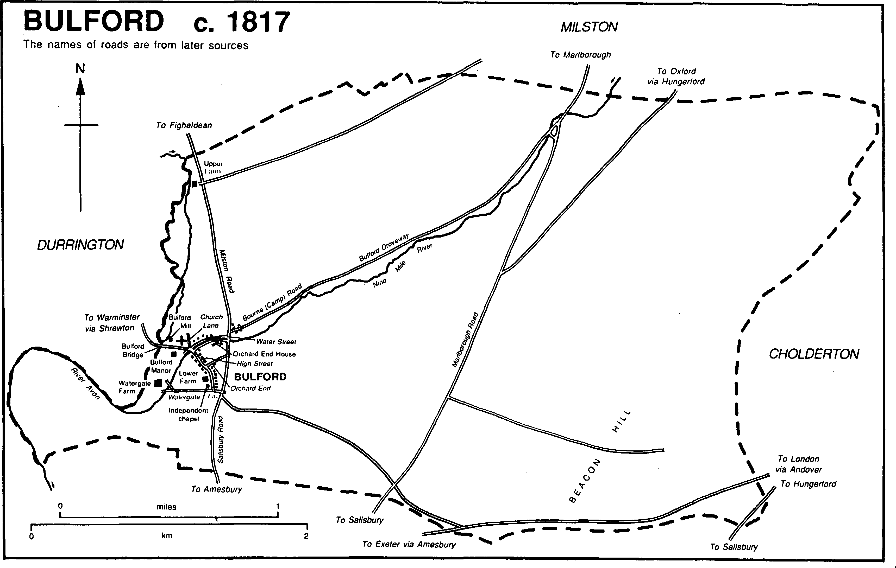
Bulford (fn. 1) village is 2.5 km. north-east of Amesbury; the rectangular parish is in the valley of the Christchurch Avon on the east side of the river and contains 1,474 ha (3,642 a.). (fn. 2) Most parishes of Bulford's size in the Avon valley contained more than one settlement and tithing, and Bulford may have done so. Hindurrington was in the Middle Ages, but not later, the name of a settlement or a tithing or both: its name has led to the suggestion that it was in the neighbouring Durrington parish, (fn. 3) but the survival of the name for a farm and a field in Bulford in the 17th century, (fn. 4) and the size of Bulford parish, which contained only one settlement and one tithing without it, show that Hindurrington was in Bulford. In the 20th century a large army camp was built in the parish and from c. 1898 much land was used for military training.
Bulford c. 1817
The parish boundaries may be those of Amesbury abbey's Domesday estate called Bulford, (fn. 5) and there is no evidence of a change in them. The western, with Durrington, is the Avon, part of the northern follows a dry valley, and the east part of the southern and the north part of the eastern, which separates Wiltshire from Hampshire, are marked by prehistoric ditches.
Chalk outcrops over nearly all the parish; a small area of Reading Beds is on the summit of Beacon Hill. Alluvium and gravel have been deposited by the Avon and its tributary, Nine Mile river, which flows south-west across the parish. (fn. 6) Apart from in the south-east corner, where Beacon Hill reaches 204 m., and along the eastern boundary, the relief in the parish is gentle. Land use was typical of the Wiltshire chalklands: there were meadows beside the Avon and Nine Mile river, open fields on the gravel and lower slopes of the downs, and rough pasture on the higher land furthest from the village. (fn. 7) In 1918–19, to commemorate the use of Bulford camp by New Zealand forces, the chalk on a north-west facing part of Beacon Hill was exposed to form the figure of a kiwi. (fn. 8)
Three main roads crossed the parish in the later 17th century. The road from Chipping Campden (Glos.) via Marlborough to Salisbury crossed the centre of the parish north—south, the road from Oxford via Hungerford (Berks.) to Salisbury crossed the south-east tip, and the road from London via Andover (Hants), Amesbury, Shrewton, and Warminster to Bridgwater (Som.) also crossed the south-east corner. By 1773 a new course, west of the old, had been adopted as the Hungerford road, which in the early 19th century ran north-east and south-west across the centre of the parish and merged with the Marlborough road east of the village. (fn. 9) A road on the north bank of Nine Mile river led south-west from the Marlborough road, crossed the Avon at Bulford village, ran through Durrington parish to Shrewton, and provided an alternative route between London and Warminster. (fn. 10) In 1761 the Andover—Amesbury road and a road across the south-west part of the parish through Bulford village to Durrington were turnpiked. A road linking the villages on the east bank of the Avon crossed the parish and through the village ran near the church. It was replaced by a road, leading from Figheldean through the east part of Bulford village to the London road at Folly bottom in Amesbury, also turnpiked in 1761. The roads were disturnpiked in 1871. (fn. 11) From 1958 the Andover—Amesbury road has been part of the London—Exeter trunk road. (fn. 12)
The Hungerford road was still important in 1833 when the inhabitants of Bulford were summoned to quarter sessions for failure to repair it. (fn. 13) That and the Marlborough road were used less after a more easterly road through the Bourne valley was turnpiked in 1835, (fn. 14) and north of the army camp were closed after the north-east part of the parish began to be used for military training. (fn. 15) The road linking the Marlborough road and Bulford village, called Bourne Road in 1838, (fn. 16) later Bulford Drove way and Camp Road, remained open and was joined across Sheep bridge to a new road, made in 1909–10 to replace the Hungerford road, running north-east and southwest below Beacon Hill between Tidworth camp and Bulford camp. (fn. 17)
The Amesbury and Military Camp Light Railway, a branch of the L. & S.W. R., was extended as a single track from Amesbury through Bulford village to a terminus 3 km. ENE. of the church in 1906. There was a station for the public south of the village, another station for passengers at Bulford camp, and a goods depot at the terminus. The line was closed to passengers in 1952 and entirely in 1963. (fn. 18)
A belief in the prehistoric significance of a large sarsen submerged in the Avon south of Bulford bridge and of another standing on high ground south-east of the village in the 19th century has been discredited. (fn. 19) The etymology of Haradon Hill, the name used for the summit of Beacon Hill in the 18th century, may refer to prehistoric religious rites. (fn. 20) Bulford is in an area of early settlement, and Neolithic, Bronze-Age, Pagan Saxon, and Romano-British artefacts have been found on Beacon Hill and other downland. A prehistoric ditch, distinct from the two on the boundaries, runs from Beacon Hill first north, then east, and again north into and across Milston parish. A small prehistoric field system lies south of Bulford village, and part of a large one extends into the south-east part of the parish from Amesbury. (fn. 21) There are numerous barrows of various types on the downs, and on Beacon Hill there is a cemetery of 70 or more bowl barrows with associated burials and cremations. (fn. 22)
Bulford and Hindurrington had a total of 125 poll-tax payers in 1377. (fn. 23) The population of the parish rose from 228 in 1801 to 408 in 1851, and declined to 343 in 1871: the decline from 383 in 1861 was caused by the death of more old people than usual, migration, and temporary absence of some families. The population remained almost constant 1871–91 but increased rapidly with the establishment of Bulford camp c. 1898. In 1901 it was 1,386 including 435 construction workers and 608 soldiers. The military population continued to grow and most of the 3,923 inhabitants in 1931, and of the 5,213 in 1951, lived in the camp. (fn. 24) The population declined to 4,125 in 1961, rose to 5,889 in 1971, and in 1991 was 5,255. (fn. 25)
Bulford village grew up on the gravel beside the Avon; Hindurrington, probably a settlement in the Middle Ages, is likely to have been on a similar site further north. The village had three main lines of settlement. The church, two 17th-century manor houses, a mill, and some principal farm buildings were all on or near the old road on the east bank of the Avon superseded in 1761. That road, part of which survives as Church Lane, was crossed at the church by the London—Warminster road, there wide enough for Nine Mile river to flow along the middle of it (fn. 26) and later called Water Street. A line of about eight houses, most perhaps the copyhold farmhouses of Bulford manor, survives in Water Street. The houses, characteristically of flint and red brick with thatched roofs, are apparently mostly 18th-century. One on the south side of the street, Orchard End House, was built of flint and chalk in the 17th century and altered in the early 19th, when new windows were inserted in the south entrance front and tall cob walls were built to enclose a garden. Water Street presumably went out of use as a thoroughfare after other roads through the village were turnpiked, and by the late 19th century was no more than a footpath beside the watercourse. (fn. 27) Thereafter local needs were served by the Old Coach Road north of it.
The ford which gave the village its name was replaced by a bridge, possibly c. 1761 when the road to Durrington was turnpiked. Through Bulford village that road is called High Street. Lower Farm on the west side of it is a 17th-century farmhouse, of flint with stone quoins, altered and extended in the 19th-century. An inn, the site of a 19th-century school, and a house converted to a school are on the east side, and a nonconformist chapel stands at the junction with Watergate Lane.
Buildings in the village, possibly the north part, were destroyed by fire c. 1685, (fn. 28) and a farmstead called Hindurrington, apparently not far north of the church, had been demolished by 1758. (fn. 29) A new farmstead, Upper Farm, possibly replacing farm buildings at Bulford Manor, (fn. 30) had been built beside the turnpike road from Figheldean near the northern parish boundary by 1773. (fn. 31) The farmhouse, of flint with red-brick dressings, was altered and extended in the 19th century. Near the village a vicarage house was built in the late 19th century beside the Figheldean road, which was called Milston Road north of the village, Salisbury Road through and south of it, but otherwise there was little settlement beside the road before the 20th century.
There was one inn or more in the village from the earlier 16th century. (fn. 32) One was called the Lamb in 1604, (fn. 33) one the Maidenhead in 1764 and the 1820s. (fn. 34) The Rose and Crown in High Street was open in 1844, (fn. 35) rebuilt in 1896, (fn. 36) and open in 1992. A friendly society met at the Maidenhead in the late 18th century and early 19th: it had 70 members in 1803, c. 112 when the population of Bulford was only c. 230 between c. 1812 and 1815. (fn. 37) A friendly society which met at the Rose and Crown was dissolved in 1889. (fn. 38) There was a brass band and a choral society in the village in 1903. (fn. 39)
There were few buildings in the east part of the parish before c. 1898. Farm buildings erected on the east side of Beacon Hill in the earlier 19th century were demolished in the mid 20th; (fn. 40) the site of a cottage standing in the earlier 19th century near the boundary with Cholderton east of Beacon Hill was used c. 1900 for Scotland Lodge, a large house of flint and red brick on H. C. Stephen's Cholderton estate; (fn. 41) four cottages at Bulford Penning west of Beacon Hill in the mid 19th century were demolished in the early 20th. (fn. 42)
Bulford village grew north, south, and east in the 20th century. The new houses were presumably built for civilians working at Bulford camp, and in the late 1960s an eastwards extension of the village met a westwards extension of the camp. (fn. 43) The old part of the village, however, was little affected: on the site of the old school in High Street (fn. 44) an estate of private houses and a working men's club were built in the 1980s, in Orchard End two houses incorporating shops were built in 1927 (fn. 45) and a large house in the grounds of Orchard End House was built in 1991, (fn. 46) and in Watergate Lane several houses were built after the Second World War. A reading room in High Street in the earlier 20th century was replaced by a village hall in Watergate Lane. (fn. 47) To the north the village was extended by the building of three large houses for army officers east of the Vicarage between 1901 and 1926, (fn. 48) of a police station and three terraces each of four council houses on the east side of Milston Road in the late 1920s, (fn. 49) and of three houses for soldiers between the Vicarage and the council houses in 1954. (fn. 50) After the rail way station was built at the south end of the village in 1906 the south-east extension of High Street, leading to the Andover—Amesbury road, was called Station Road. On the west side of Salisbury Road south of its junction with High Street private houses were built in the early 20th century; (fn. 51) on the east side of Station Road two terraces each of four council houses were built in 1927; Station Terrace, 16 council houses in pairs, was built on the west side of Station Road and the east side of Salisbury Road in 1931. (fn. 52) The station and a house and two cottages built nearby c. 1906 were demolished after c. 1965, and from 1969 the site has been occupied by extensive offices of the Property Services Agency. (fn. 53) The growth of the village eastwards took place after the Second World War when, to replace temporary housing north-east of the village, a large council estate was built east of Salisbury Road along the line and immediately south of Nine Mile river in the 1950s and 1960s. By 1955 c. 82 houses had been built near Salisbury Road in St. Leonard's Close, the Crescent (later Crescent Road), and Meadow Road. (fn. 54) In the 1960s building continued further east in John French Way and Churchill Avenue, parallel north-east and south-west roads, and in roads connecting them. (fn. 55) Also in the 1960s 11 old people's bungalows were built in the angle of High Street and Salisbury Road. (fn. 56)
Bulford camp, (fn. 57) mostly between Nine Mile river and the foot of Beacon Hill, (fn. 58) was a principal base of the Royal Artillery 1905–77, the base of the New Zealand expeditionary force 1914–18, and from 1977 the headquarters of South West District command. Rifle ranges were set up 1898–9, and by 1901 had been incorporated in a camp which was hutted to the south, tented to the north. The Marlborough—Salisbury road became the main road through the camp, there called Marlborough Road, but was closed a little north of it. (fn. 59) The south part of the camp was served by a new road, Bulford Road, leading south-east from Camp Road; east of the junction Bulford Droveway also served the camp. Permanent red-brick barracks were built on a grid pattern either side of Marlborough Road c. 1910. From 1914 Sling barracks to the north replaced the tents and housed the New Zealand forces. The barracks were all called after First World War battles 1922–38, but from 1938 were renamed; Beacon (now Picton) and Kiwi barracks are east of the road, Gordon, Ward, and Wing are west of it. Sling barracks had been partly demolished by 1923. Marlborough barracks were also west of the road: they lost their identity after c. 1961 when part was merged with Ward, part with Gordon, and part with Wing barracks. Beacon barracks were rebuilt 1967–76, Gordon c. 1976. Carter barracks, a hutted camp north of Bulford Droveway, were built 1939–40 and demolished in 1978. At its most extensive, in the 1960s and 1970s, Bulford camp covered c. 640 a.
Mainly on the perimeter of the camp extensive housing estates, several with tree-lined roads, were built for soldiers and their families. To the north houses were built on the site of Sling barracks in 1937–8, 1952, and 1968; the Australian estate was built east of Kiwi barracks in 1963; in the north-west the Irish estate was built in 1968, and in the west the Canadian estate was built in the same year. Army housing built in 1969 in Dorset Close, Hampshire Close, and Wiltshire Close, all west of Bulford Road, linked the Canadian estate to the council housing in Churchill Avenue and John French Way.
Bulford camp has been provided with most of the facilities of a small town, including churches, (fn. 60) hospitals, schools, (fn. 61) sports grounds, a theatre, and cinemas. A new cinema opened in 1939 in Marlborough Road was standing in 1992 but not open. Before 1910 a dairy, shops, and branches of banks had opened. (fn. 62) On the site of a hospital west of Marlborough Road, a police station, opened in 1966, (fn. 63) a shopping centre, opened in the 1970s, and a NAAFI were built. The Saxon Warrior inn was opened in 1974. Two packs of Royal Artillery hounds have been based at the camp, harriers 1907–17 and 1919–39, for which kennels were built in 1934, and foxhounds from 1942. (fn. 64)
Manor and other estates.
Ames-bury abbey held BULFORD from before the Conquest: 3 hides held by Alward in 1086 were part of the abbey's estate in 1066 and probably again later. (fn. 65) When the manor was confirmed to Amesbury priory in 1179 it included land at Hindurrington, (fn. 66) and in 1286 the priory was granted free warren in its demesne at Bulford and Hindurrington. (fn. 67) From the Dissolution to 1614 the manor belonged to the Crown: (fn. 68) in 1610 James I settled it on Henry, prince of Wales (d. 1612). (fn. 69) In 1614 Leonard Welsted bought it and sold it to (Sir) John Daccombe, who sold it in moieties. (fn. 70)
The lordship and a moiety of the manor were bought in 1614 by George Duke (fn. 71) (d. 1618), who devised the estate, called Bulford manor and including Hindurrington farm, to his sons An drew (d. 1633) and George, a lunatic from 1627, in moieties. Andrew devised his moiety to his brother John, to whom the younger George's son George sold his in 1647. (fn. 72) The estate passed from John (d. 1671) to his son Andrew (d. 1678) and to Andrew's relict Mary (fl. 1682) and son Andrew (d. 1730). In 1719 Andrew gave Hindurrington farm to his son Andrew (d. s.p. 1727) for life: he was succeeded in the whole estate by his son Richard (fn. 73) (d. 1757), who devised it in moieties to his sisters Anne (d. 1770), wife of Anthony Southby, and Mary. Anne's son Richard Southby inherited Mary's moiety and in 1764 Anne gave hers to him in an exchange. Richard (d. 1791) was succeeded in turn by his son Richard (d. 1791) and, as joint owners, by his daughters Charity (d. s.p. 1830), who married Sir John Pollen, Bt., and Mary (fn. 74) (will proved 1835). (fn. 75) In 1835 the estate passed to Mary Southby's kinsman Anthony Gapper (d. 1883), (fn. 76) who assumed the name Southby in 1835, (fn. 77) and from Anthony it passed to his son Edmund Southby (d. 1886). Edmund's trustees sold it in 1886 to J. L. Hill, (fn. 78) who in 1898 sold Bulford Manor and 1,899 a. to the War Department. The Ministry of Defence was the owner in 1992. (fn. 79)
Bulford Manor was built in the 17th century of stone and flint, and consisted of a long and narrow east—west range with a principal north front. (fn. 80) In the early 18th century, for Andrew Duke (d. 1730), a red-brick range incorporating a staircase was built on the south side to form a square house. (fn. 81) An embattled stone bay window was constructed on the west side of the 17th-century range in the mid 19th century, and in the 1890s a large service wing was built for J. L. Hill at the south-east corner of the 18th-century range. The service wing, of flint and stone to the north, red brick to the south, incorporates stables at its north-east corner. (fn. 82)
The second moiety of Bulford manor was bought in 1617 from Sir John Daccombe by Sir Laurence Washington (fn. 83) (d. 1643): it became known as Seymour's, afterwards as WATERGATE farm. It descended to Sir Laurence's son Laurence (d. 1661) and to Laurence's daughter Elizabeth, from 1671 the wife of Sir Robert Shirley, Bt. (Baron Ferrers from 1677, Earl Ferrers from 1711). (fn. 84) Elizabeth and Robert sold it in 1678 to Sir Edward Seymour (fn. 85) (Bt. from 1685, d. 1708), speaker of the House of Commons. It passed to Sir Edward's son Sir Edward (fn. 86) (d. 1740), who devised it to his son William (d. 1747). (fn. 87) It descended in the Seymour family, apparently belonged to Francis Seymour in 1780 and to William Seymour in 1808–9, (fn. 88) and in 1817 was Henry Seymour's. The farm, 1,633 a. in the south part of the parish, passed from Henry (d. 1849) to his sons Henry (d. 1877) and Alfred (d. 1888) successively. Alfred's heir, his daughter Jane (d. 1943), in 1897 sold 383 a. on Beacon Hill to H. C. Stephens: (fn. 89) that land passed with Stephens's Cholderton estate to P. M. L. Edmunds, who sold 101 a. in 1933, and Mr. H. A. Edmunds, who sold c. 200 a. in 1986. In 1992 the c. 300 a. belonged to the Ministry of Defence, the c. 80 a. to Mr. H. A. Edmunds. (fn. 90) Jane Seymour sold 751 a. in 1898, II a. in 1899, and 288 a. in 1901, all to the War Department: the Ministry of Defence owned that land in 1992. (fn. 91) About 200 a. passed in 1943 to Jane's cousin Sir Frederick Rawlinson, Bt., (fn. 92) who sold them to H. J. Street in 1947. Street immediately sold Watergate House and 6 a. to Sir Noel Beresford-Peirse (d. 1953), whose relict Camilla sold them in 1985 to Dr. Charles Goodson-Wickes, M.P., the owner in 1992. (fn. 93) Of Street's other land some belonged in 1992 to Mr. M. Rowland, some to the Ministry of Defence. (fn. 94)
Watergate House was built in 1618, (fn. 95) evidently for Sir Laurence Washington, as a small stone house with an east entrance front and, on the ground floor, one room north and one room south of a central stack. About 1800 the addition of a block to the west, mostly of stone and flint, made the house square, and a south entrance front, of chequered flint and ashlar, was made across both the old and new parts. A verandah was built along the south front later in the 19th century. An L-shaped red-brick service wing was built on the north side of the house in the mid 19th century. Two large 17th- or early 18th-century aisled barns stand north-west of the house.
William Andrews (d. 1637) bought c. 50 a. in Bulford and Hindurrington from John Daccombe's feoffees, presumably c. 1614, and before 1633 c. 58 a. from Philip More. (fn. 96) The 108 a., with pasture rights, passed successively to his relict Alice and grandson William Andrews, presumably the William Andrews who sold the estate to Lancelot Addison, rector of Milston, part in 1672 and part in 1674. (fn. 97) In 1692 Addison sold it to Andrew Duke, who added it to Bulford manor. (fn. 98)
A small estate, later CHAFYN'S farm, at Hindurrington was held c. 1550 by William Chafyn (fn. 99) (d. 1558), who devised it to James Foxhanger. (fn. 100) It was owned in 1604 by William Staples (fn. 101) and may have been the farm owned in 1804 by William Dyke, in 1825–6 by T. W. Dyke, (fn. 102) and in 1838–9, when it was 73 a. and included Orchard End House, by Richard and John Cooe. (fn. 103) The War Department owned the land in 1910, (fn. 104) the Ministry of Defence in 1992. (fn. 105)
The tithes from the parish may have been taken by Amesbury abbey, and in 1179 were confirmed to Amesbury priory. (fn. 106) The RECTORY estate, which included 1 yardland besides the tithes, (fn. 107) passed with Bulford manor to John Daccombe, and from 1614 with the reduced Bulford manor in the Duke and Southby families. (fn. 108) Watergate farm, owned by the Washington and Seymour families, (fn. 109) was free from great tithes, and the tithes from the reduced Bulford manor were merged with the land from which they arose. In 1838 the small tithes from Watergate farm, and the great and small tithes from remaining land in the parish, 76 a., were valued at £97 and commuted. (fn. 110)
Economic history.
In 1086 Bulford had land for 9 ploughteams and 8 are known to have been there. On Amesbury abbey's 12-hide estate half was demesne, on which were 13 servi and 3 teams. Of the other half 3 hides may have been held by lease and have supported 1 team, and on 3 hides 3 villani, 20 coscets, and 3 cottars had 5 teams. There were 35 a. of meadow, and pasture 1 league by ½ league. (fn. 111)
Sheep-and-corn husbandry typical of Wiltshire chalk country prevailed in the parish in the Middle Ages and until the 20th century. Produce of the demesne was used to stock the larder of Amesbury priory in the early 14th century; in the mid 15th century and later the demesne was leased. (fn. 112) Apart from the demesne there were 25 copyholds, including 1 of 2½ yardlands, 1 of 2 yardlands, 2 of 1½ yardland, 5 of 1 yardland, and 14 of ½ yardland or less. A leasehold of 43 a. may formerly have been two copyholds, and, since they shared Stewards mead with the lessee of the demesne, two copyholds, of 30 a. and 40 a., may formerly have been demesne. (fn. 113)
In the mid 16th century four open fields, North, Middle, South, and Hindurrington, contained 790 a., Michell mead was a common meadow of 25 a., (fn. 114) and North and Hindurrington downs provided 500 a. of pasture in common. (fn. 115) The process of inclosure had begun in the early 16th century when William Chafyn, lessee of the demesne from 1502, inclosed c. 16 a. of arable, converted it to meadow land, and may have inclosed a further c. 72 a. of arable. (fn. 116) About 1550 the demesne included two several downs, Middle and South, (fn. 117) on which a flock of 1,200 sheep could be kept, (fn. 118) and 37 a. of mainly several meadows. (fn. 119) In 1584 the lessee inclosed his remaining open arable, 205 a. in North, South, and Hindurrington fields, and Michell mead. To compensate them for their loss of common rights at that inclosure the lessee gave to the customary tenants other open arable, later called High field and Low field, and New leaze, Middle leaze, both mainly inclosed, and Old leaze. In 1604 the demesne included pasture rights on the 200-a. Hindurrington down but was otherwise mainly several and was apparently a very large farm. The commonable lands of the parish remained extensive: there were still six open fields of which two, High and Low, contained 349 a., and the downland included North down, 300 a., but most of the tenants' 61 a. of meadow land had been inclosed. (fn. 120)
The large demesne farm was divided in the 17th century, presumably c. 1614 when Bulford manor was sold in portions. (fn. 121) The northern part had itself been divided by 1659 when it was in two farms, Manor and Hindurrington: (fn. 122) Manor may have been worked from buildings on the site of Bulford Manor, Hindurrington from buildings north of the church. (fn. 123) In 1678 Manor farm had on it c. 1,000 sheep and 16 cows. (fn. 124) The southern part of the demesne was later Watergate farm. (fn. 125) In the 18th century Upper Farm was built, apparently as a new farmstead for Manor, or Upper, farm, and new buildings were presumably erected for Hindurrington farm. (fn. 126) In 1604 there were 17 farms held on lives by copy or lease, much copyhold land having been converted to leasehold between 1584 and then; (fn. 127) in 1744 there were 16. (fn. 128) Richard Duke (d. 1757), lord of Bulford manor, directed that his successor should allow the tenancies of the leaseholds and copyholds for lives to fall in and should add the land to Upper and Hindurrington farms. He also forbade his successor to plough or burnbake downland. (fn. 129) There was a private inclosure agreement in 1827, (fn. 130) and by 1838 the smaller farms had been absorbed by Upper and Hindurrington farms and open-field cultivation and common husbandry had been eliminated. In 1838 Upper farm was 810 a., Hindurrington farm 960 a., and Watergate farm 1,633 a. A fourth farm, 73 a., was worked from Orchard End House. (fn. 131)
Meadows beside the Avon and Nine Mile river were watered from the 17th century to the earlier 20th. (fn. 132) Although no downland in either Upper farm or Hindurrington farm was burnbaked, some in Watergate farm was, and in 1838 that farm had an additional farmstead on the downs at Bulford Penning. There was slightly more arable than pasture in the parish in 1838. (fn. 133) From c. 1860 about a third of the parish was arable and the chief grain crop was barley. Numbers of sheep pastured on the downs increased from c. 3,000 in 1867 to c. 4,500 in 1886. Arable was sown with temporary grasses, fewer sheep were kept, and herds of dairy cows increased 1886–96. Agriculture ceased on more than half the parish after 1898 as land was used for military training and for Bulford camp. On the other land arable continued to decline and cattle to replace sheep. (fn. 134) More land was ploughed after 1939. In 1992 of c. 350a., mostly arable, in the south-west corner of the parish c. 150 a. were worked with Ratfyn farm, based in Amesbury; (fn. 135) the c. 250 a. of agricultural land in the north-west corner were used mainly for growing cereals; there was also arable on the c. 80 a. of farmland in the south-east corner.
There was no woodland in the parish until 38 a. in Sling plantation were planted between 1820 and 1838. (fn. 136) Plantations north-east of Nine Mile river and on Beacon Hill were made between c. 1877 and 1899. (fn. 137) More trees were planted around Bulford camp and on the downs from 1964, and in 1991 there were c. 360 a. of woodland in the parish. (fn. 138)
Amesbury abbey's Bulford estate had two mills in 1086, (fn. 139) and Amesbury priory is known to have had mills at Bulford in the 13th century (fn. 140) and the 14th. (fn. 141) In 1539–40 there were two mills on Bulford manor, possibly in one building. (fn. 142) All those mills were presumably on the Avon. A new mill was built between 1726 and 1735. (fn. 143) At Bulford mill, on the Avon near the church, paper was made from 1765 to the 1870s: (fn. 144) the mill house is a red-brick building of the 19th century.
In 1831 most men in Bulford were farm labourers, but a few followed retail trades, presumably outside the parish. (fn. 145) In the 20th century nearly all the trade and industry in the parish has been at Bulford camp. (fn. 146)
Local government.
Presumably under a general confirmation of liberties to Amesbury priory in 1179, view of frankpledge, in addition to a manor court, was held for Bulford manor in the Middle Ages. (fn. 147) While the Crown owned the manor 1539–1614 tenants of neighbouring royal estates owed suit at Bulford, (fn. 148) and the lessee of the demesne was obliged to accommodate the steward who held the courts. (fn. 149) Views and courts for the smaller Bulford manor were held in 1675 (fn. 150) but none is expressly mentioned afterwards.
In 1802–3 a quarter of the population of the parish received poor relief: £164 was spent on materials for employing some, on regular outrelief for 20 adults and 27 children, and on occasional relief for 8 adults. (fn. 151) An average of £193 a year was spent 1812–15, and on average 14 were relieved regularly and 8 occasionally. (fn. 152) Among the parishes of Amesbury hundred Bulford spent more than average on the poor 1816–21, less than average 1822–34. (fn. 153) Bulford became part of Amesbury poor-law union in 1835. (fn. 154) It was included in Salisbury district in 1974. (fn. 155)
Churches.
A church stood in Bulford in the early 12th century. It is likely to have belonged to Amesbury abbey and was confirmed to Amesbury priory in 1179. (fn. 156) Until the Dissolution the church was served by chaplains appointed by the priory, (fn. 157) and the right to nominate curates passed with the Rectory estate, the owners of which were lords of Bulford manor. (fn. 158) A proposal of 1650 to unite Bulford and Milston parishes was not implemented. (fn. 159) From 1868 the living was a vicarage in the gift of the lord of the manor. (fn. 160) It was united with the benefice of Figheldean with Milston in 1982 and the Secretary of State for Defence, as lord of the manor, was allotted a share of the patronage. (fn. 161)
In 1535 the chaplain received a stipend of £5 6s. 8d. and a livery of 13s. 4d. By c. 1540 he had been allowed an extra 6s. 8d. (fn. 162) which he still received in 1567. (fn. 163) The stipend was £20 in 1650, (fn. 164) £51 c. 1830. (fn. 165) Between 1838 and 1864 the owner of the Rectory estate gave the rent charge at which the small tithes from Watergate farm were commuted, £75 in 1838, to the curate as a stipend. (fn. 166) The vicar received the same rent charge after 1868, and in 1883 the patron augmented it with £100 a year. (fn. 167) From the 16th century to the 19th a house for the curate was sometimes provided by the owner of the Rectory estate. (fn. 168) A vicarage house, built to C. E. Ponting's designs in 1893, (fn. 169) was sold in 1978. (fn. 170)
Before 1548 a small flock of sheep was given to pay for a candle in the church. (fn. 171) The curate lived in Amesbury in 1550. Liturgical practice was conservative in 1553, when the altar and crosses were still in the chancel and no sermon was preached. (fn. 172) The curate preached every Sunday in 1650. (fn. 173) The curates appointed in the 18th century were incumbents or curates of neighbouring or nearby parishes. George Lewis, curate from 1712 to c. 1724, was vicar of Figheldean. (fn. 174) In 1783 the curate was also curate of Boscombe and lived either there or in Amesbury. The service which he held at Bulford every Sunday morning was well attended, and at Christmas, Easter, and Whitsun he administered the sacrament to 6–10 communicants. (fn. 175) A service was held every Sunday in 1833, (fn. 176) and on Census Sunday in 1851 the service, held in the afternoon, was attended by 138. (fn. 177) T. D. Millner, curate from 1852 to c. 1868, was domestic chaplain to the Lord Lieutenant of Ireland and did not reside regularly. In 1859 the bishop enjoined him to do so: he apparently did not comply and employed a deputy. Each Sunday in 1864 two services were held: sermons were preached at both, except on the first Sunday in each month when, presumably after morning service, the sacrament was administered instead. Communion was also celebrated at Christmas, Easter, Ascension, and Whitsun, and there were 66 regular communicants. Weekday services were held at minor festivals and on Wednesdays in Lent. (fn. 178)
The church of ST. LEONARD, so dedicated by c. 1900, was called St. John the Evangelist's in 1763 and c. 1875. (fn. 179) It is built of flint rubble with stone dressings and some brick patching; and most of it is rendered. It comprises a chancel and a nave with north transept and south porch above which is a tower. (fn. 180) The chancel arch and the east, south, and west walls of the nave survive from the early 12th century. The chancel and the north wall of the nave were rebuilt in the late 12th century, and in the 13th the south doorway of the nave was renewed and the porch and tower were built. Between c. 1300 and c. 1500 new tracery was inserted in most windows of the chancel and nave; in the 16th century the east window, possibly of three stepped lancets, was replaced by a traceried three-light window flanked inside by niches for statues. The chancel roof was reconstructed in the 16th century, the south doorway of the porch was renewed in the early 17th, and, also in the 17th, the nave roof was rebuilt and apparently designed for a flat ceiling. By 1826 an earlier north transept had been replaced by a narrower and longer one incorporating a north gallery above a vestry. (fn. 181) The church was restored to C. E. Ponting's designs 1902–11. (fn. 182) Traces of medieval wall paintings survive on the north and east nave walls. (fn. 183)
A 15½-OZ. chalice was left for parish use and 15 oz. of plate were taken for the king in 1553. In 1891 and 1991 a chalice hallmarked for 1570 and a flagon hallmarked for 1636 belonged to the parish. (fn. 184) There were three bells in 1553. They were replaced by, or recast as, two bells made by John Wallis in 1614; those two were recast as one by Taylor of Loughborough (Leics.) in 1911. (fn. 185) Registrations of baptisms and marriages survive from 1654, of burials from 1655. Baptisms are lacking 1685–1761, marriages 1691–1790, and burials 1678–1766. (fn. 186)
To serve Bulford camp the church of ST. GEORGE was built 1920–7 to designs by Blount & Williamson. (fn. 187) It is a large church of stone consisting of a chancel with south vestry and transepts, an aisled nave, and a west baptistry, and is in 14th-century style. (fn. 188)
Roman Catholicism.
From 1910 there were mass centres at Bulford camp in temporary accommodation on various sites. The Roman Catholic church of Our Lady of Victories was opened in 1925. It closed in 1968 when the church of Our Lady Queen of Peace, built to J. A. Douglas's designs, was opened. (fn. 189)
Protestant nonconformity.
Five or six Baptists were inhabitants of Bulford in 1669, a Baptist meeting house was licensed in 1672, (fn. 190) and there were two dissenters there in 1676. (fn. 191) A meeting house for Wesleyans at Bulford paper mill was certified by Thomas Mold in 1781, (fn. 192) but in 1783 there was said to be no nonconformist in Bulford. (fn. 193) Independents certified two houses in 1805, and in 1806 certified a new chapel partly paid for by Matthew Devenish of Watergate Farm. (fn. 194) The chapel was rebuilt in 1828; in 1851 on Census Sunday 119 attended the morning service, 128 the afternoon one. (fn. 195) From 1851 or earlier until 1955 the minister lived in a manse in High Street. (fn. 196) A register of births and baptisms survives for 1806–37. (fn. 197) From 1965 the chapel was an independent evangelical church in the Evangelical Fellowship of Congregational Churches. (fn. 198) Services were still held in 1991.
Education.
By will proved 1758 Richard Duke gave money for a school to be built in Bulford churchyard and for land worth £8 a year to support a teacher and buy books. No land was bought, but a school was started. In 1833 £8 was paid to it by the tenant of Upper farm, afterwards, until 1892 or later, by the lords of Bulford manor, who gave an additional £12 until c. 1888, an additional £7 thereafter. (fn. 199) The school was attended by 12 in 1818, (fn. 200) 16 in 1833, (fn. 201) and 15–20 in 1858 when it was in a cottage near the churchyard. (fn. 202) On attendance day in 1871 there were 39 children present. (fn. 203) A new school was built in High Street in 1874. (fn. 204) Average attendance was 65 in 1906, (fn. 205) 46 in 1907–8, 79 in 1911–12. Figures fell slightly after schools were opened in Bulford camp, and in 1938 the average was 52. (fn. 206) The school was closed, and a new one in John French Way opened, in 1971. In 1991 a quarter of the 211 pupils were soldiers' children. (fn. 207)
In Bulford camp Haig county primary school in Haig Road opened in 1929, was enlarged in 1968 and 1974, (fn. 208) and had 108 children on roll in 1991. (fn. 209) A school in Wing barracks opened before 1915 was renamed Wing county junior school in 1955 and closed in 1964. Its pupils were transferred to Kiwi county primary school, opened in 1965 on the site of a former infants' school in Hubert Hamilton Road. (fn. 210) There were 231 children on roll in 1992. (fn. 211)
In 1858 a woman taught 20–30 children in a British school attached to the Independent chapel. (fn. 212) There is no later evidence of the school. A private school, Avondale, founded in Amesbury in 1923, moved in 1957 to the former manse in High Street. (fn. 213) It had 115 pupils in 1991. (fn. 214)
Charity for the poor.
None known.