A History of the County of Wiltshire: Volume 14, Malmesbury Hundred. Originally published by Victoria County History, London, 1991.
This free content was digitised by double rekeying. All rights reserved.
'Parishes: Brinkworth', in A History of the County of Wiltshire: Volume 14, Malmesbury Hundred, (London, 1991) pp. 13-25. British History Online https://www.british-history.ac.uk/vch/wilts/vol14/pp13-25 [accessed 25 April 2024]
In this section
BRINKWORTH
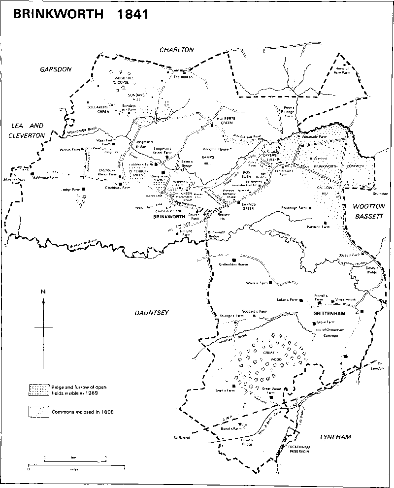
Brinkworth 1841
Brinkworth village is 8.5 km. ESE. of Malmesbury. (fn. 1) The parish, shaped like Africa, is one of the largest in north Wiltshire: it contains the village with several small outlying settlements nearby, Grittenham hamlet, and many scattered farmsteads. The north part of the parish was Brinkworth tithing, the south Grittenham tithing. (fn. 2) About 1320 c. 300 a. east of the village were apparently lost to the parish when the lord of Brinkworth manor allowed them to be inclosed in Vasterne park, and they became part of Wootton Bassett parish. (fn. 3) Brinkworth village was never in Braydon forest, but it was near its 13th-century boundaries, and from 1300, when the area of the forest was greatly reduced, to 1630, when it was inclosed, (fn. 4) part of the purlieus of the forest was called Brinkworth quarter: the parts of the purlieus claimed as Brinkworth's and Grittenham's were presumably defined, as other parts were. (fn. 5) When the purlieus were inclosed in the early 1630s much of Brinkworth quarter, possibly as much as 1,250 a., became part of Brinkworth parish. (fn. 6) Other parts of the quarter allotted to Milbourne in Malmesbury and to Little Somerford, a total of 309 a., were transferred to Brinkworth in 1884. (fn. 7) To the south-east 42 a., a detached part of Dauntsey, were transferred to Brinkworth in 1884 and, to the south, a total of 16 a. were transferred from Dauntsey and Lyneham between 1891 and 1901: Brinkworth parish thereafter measured 2,459 ha. (6,075 a.). (fn. 8)
Streams and roads mark much of the parish boundary. That with Dauntsey, the east—west part of which was marked by Brinkworth brook, had been fixed by the early 13th century; (fn. 9) that with Wootton Bassett, marked by a road and Lilly brook, is presumably of c. 1320. (fn. 10) In the 13th century the southern boundary of Braydon forest followed Grittenham brook on the east: (fn. 11) from the Brinkworth village, passed east of the village on a roughly north-west and south-east line, and followed Brinkworth brook on the east: (fn. 11) from the early 1630s the parish's northern boundary was marked by a road at its east and west ends, from 1884 for its whole length. Woodbridge brook also marked a small part of the parish's eastern boundary, and Lilly brook the south-east boundary with Tockenham and Lyneham.
Oxford Clay outcrops over the entire parish except in a small area of the south-east, where sand, silt, and clay of the Lower Corallian outcrop. Brinkworth, Woodbridge, and Lilly brooks have all deposited alluvium. (fn. 12) The whole parish drains westwards to the Bristol Avon and is crossed by east—west ridges and valleys. Brinkworth brook flows across the centre, and near Grittenham hamlet, where it divides Brinkworth and Grittenham tithings, it is called Grittenham brook. The south is drained by its feeders Thunder brook and Lilly brook and by Dauntsey brook, which rises near Grittenham hamlet. Woodbridge brook and its feeders drain the north. The highest land, over 130 m., is in the south-east and, over 120 m., in the north-east and north-west. Sundays Hill, Ramps Hill, and Callow Hill, all in the north, are over 110 m. The part of the parish which was in Braydon forest was well wooded, the south part contains ancient woodland, and the centre contained open arable, but most of the parish has long been grassland.
The main Swindon—Malmesbury road through Brinkworth village crosses the north part of the parish from east to west on high ground: it was turnpiked in 1809 and disturnpiked in 1876. (fn. 13) Parallel to it in the south the London and south Wales motorway was built on lower-lying land and opened in 1971. (fn. 14) Elsewhere the parish was served by lanes, the courses of some of which were altered at inclosure in the early 19th century and when the motorway was built. Baker's bridge and Longman's bridge over Woodbridge brook, and Brinkworth bridge and Dovey's bridge over Brinkworth brook, were so called in 1773. (fn. 15) The Wilts. & Berks. canal was constructed across the southern tip of the parish, where seven locks carried it over rising ground, and opened c. 1801. To feed it, a reservoir was made on the Brinkworth—Lyneham boundary. The canal was closed in 1914. (fn. 16) In 1989 the towpath and the remains of a lock were visible at Bowd's bridge and the reservoir was used for leisure. The G.W.R. London—Bristol line was built north of the canal and opened in 1841. (fn. 17) A line which branched from it at Wootton Bassett to provide a more direct link to south Wales was built south of Brinkworth village, where there was a station, and opened in 1903. (fn. 18) The station was closed in 1961. (fn. 19)
The sum at which Brinkworth and Grittenham together were assessed for taxation in 1334 was among the higher for Stanley hundred. There were 123 poll-tax payers in Brinkworth and 69 in Grittenham in 1377. (fn. 20) Assessments for taxation in the 16th and 17th centuries were consistently among the highest in Malmesbury hundred. (fn. 21) The population rose from 923 to 1,042 between 1801 and 1811 when 910 lived in Brinkworth and 132 in Grittenham. In 1841 the increase of Brinkworth's population to 1,307 and of Grittenham's to 387 was attributed to the presence of 235 G.W.R. labourers in the parish. After falling to 1,273 between 1841 and 1861 the population of the parish increased to 1,436 between 1861 and 1871 because newly built cottages attracted labourers. Thereafter, despite the transfer of 9 people to the parish in 1884, it declined, and had reached 850 by 1931. With the building of new houses in Brinkworth village from 1934 the population grew steadily, and was 1,173 in 1981. (fn. 22)
Brinkworth.
Its site, on the ridge between Brinkworth brook and Woodbridge brook used by the Swindon—Malmesbury road, suggests that the village is ancient. In Brinkworth tithing in 1773 small outlying settlements west of the village were at Clitchbury Green, Giles Green, and Causeway End, north of it at Dollakers Green and Woodbridge Green, later Hulberts Green, and east of it at Barnes Green and Box Bush, and there were many outlying farmsteads. (fn. 23) Since then Brinkworth village has spread west and east along the main road to take in Causeway End, Barnes Green, Box Bush, and more recent settlement east of Box Bush as part of the village, and a new settlement called Callow Hill has grown, but there is still much scattered settlement. The older houses in the tithing are built of a variety of materials.
Brinkworth, for which the Swindon—Malmesbury road made a street, may for long have been a small village grouped around its church with, also on the south side of the street, the demesne farmstead west of it and the rectory house east of it. The farmstead, Church Farm, includes a house of the 17th century which was extended south and east in the 19th. There was an inn in the village in 1654, (fn. 24) and the White Lion was open in 1719 and 1755. (fn. 25) The Waggon and Horses east of Church Farm had been opened by 1903 and was closed between 1956 and 1966. (fn. 26) The Three Crowns, between the church and the rectory house, was open in 1801 (fn. 27) and 1989. Street Farm, on the north side of the Street, was built in 1763 and extended in 1985. (fn. 28) Cottages for paupers and a workhouse stood near the church in the earlier 19th century. (fn. 29) A friendly society begun in 1834 did not prosper, but one based at Brinkworth Primitive Methodist chapel flourished 1866–87 and another, the Brinkworth Mutual Club and Institute, at the school 1899–1912. (fn. 30) A cemetery was opened c. 1886 north of the Street. (fn. 31) New cottages were built in the later 19th century and, north of Church Farm, two pairs of council houses in 1934 and two more pairs in 1938. (fn. 32) The south part of the village in 1773 consisted of buildings in Hill End Lane, so called c. 1808, (fn. 33) and in the mid 19th century a school was built south of the church in the lane afterwards called School Hill. Hill End Lane became the approach to Brinkworth station in 1903 when a stationmaster's house and three cottages, all red-brick, were built on it and a new lane was made south of the railway line. Also south of the line Brooklands, an estate of 35 council houses, was built c. 1953. (fn. 34)
The buildings at Causeway End in 1773 included a nonconformist chapel and possibly Causeway End House, which was built in the later 18th century. None of those at Barnes Green survives: Barnes Green Farm was rebuilt and a nonconformist chapel and cottages built in the earlier 19th century. Four farmhouses at Box Bush survive from 1773. (fn. 35) Farm Hill, possibly 17th-century, has two storeys and attics, Box Bush Farm was built in the early 18th century, and Lower Box Bush Farm retains some stone-rubble walling. Box Bush House was built of red brick in the early 18th century: in the early 19th a large two-storeyed range with a mansard roof and a three-bayed south entrance front, also of red brick, was built against the south side. Further east Fritterswell Farm was also built in the 18th century and extended in the 19th, and settlement extended along the main road after the common land was inclosed in 1808. (fn. 36) The Suffolk Arms on the north side was open from the earlier 20th century. (fn. 37) In 1989 there was a continuous line of settlement from Causeway End to the Suffolk Arms. Mostly since c. 1970 new private houses have been built at Causeway End, in the main part of Brinkworth village, and in small estates at Barnes Green, in York's Lane, west of Fritterswell Farm, and north of Fritterswell Farm in an area called Stoppers Hill. (fn. 38)
Callow Hill grew as a settlement in the earlier 19th century around the junction of the Swindon—Malmesbury road and a new lane made when Brinkworth common was inclosed. Several cottages had been built there by 1841. (fn. 39) The Royal George inn on the south side of the main road was open from 1884 or earlier to c. 1970 and East End Farm was built north of the junction in the early 20th century. In the later 19th century more houses were built in the lane south of the junction, and in the later 20th small groups of private houses in the south-west angle of the lane and the road. (fn. 40)
Of the buildings in 1773 around the green formed by the wide verges of the Swindon—Malmesbury road, together called Clitchbury Green, only Clitchbury Manor Farm, standing in 1763, survives. (fn. 41) All beside the main road, Clitchbury Farm was built to the south between c. 1808 and c. 1840, Brinkworth House to the east in stone between c. 1840 and 1884, (fn. 42) and Clitchbury Manor, a double-fronted red-brick house, to the west in the early 20th century.
The open fields of Brinkworth may have been worked from farmsteads in the village in the Middle Ages, the dispersal of farmsteads beginning only after the fields had been inclosed at some date before 1587. (fn. 43) In 1773 lanes parallel to the Swindon—Malmesbury road may have marked the north and south extent of the former open-field arable. (fn. 44) Upper Field Lane, so called c. 1808, ran from Causeway End south-west and north to a junction on the main road with Rook Hays Lane, which ran north to Longman's Street. (fn. 45) Coins and a tile kiln found nearby suggest that Longman's Street is of Romano-British origin. (fn. 46) Following Woodbridge brook, it was near the 13th-century boundary of Braydon forest. From c. 1808 or earlier its eastern end was called Slough Lane, and in 1989 it was a wide green road. Five lanes, Dead (so called in 1736), Narrow, Weeks, Almshouse (later Shoemaker), and York's, linked Longman's Street and Slough Lane with the Swindon—Malmesbury road. (fn. 47) About nine farmsteads have been built in those lanes and four are of the late 16th or early 17th century. Weeks Farm, mostly rebuilt in the 19th century, retains a plan of c. 1600 and a timber-framed wall; Whitehouse Farm, built c. 1700, was apparently preceded by a house called Gaggs Place c. 1581; (fn. 48) Giles Green Farm, much altered, was built in the early 17th century as a timber-framed house. Waldron's Farm is a cruciform stone house built c. 1600: it was presumably built for a Walrond and, because of its plan, possibly for a recusant. (fn. 49) The rooms were arranged round a central staircase, two service rooms and a hall respectively in the shorter north and south wings, and a kitchen and parlour in the longer west and east ones. There is a moat on the north side of the house. Of the other farmhouses Lodge Farm was built in the 18th century and enlarged c. 1909, Longman's Street Farm is a red-brick house of the mid 18th century, York's was rebuilt in 1873 for John Collingborn, (fn. 50) West End Farm was rebuilt in the 20th century, and Latimer's was demolished c. 1955. (fn. 51) Of other scattered settlement in Slough Lane in 1773 none survived in 1884. (fn. 52)
Four other farmsteads in the south part of Brinkworth tithing in 1773 were also on old inclosures. (fn. 53) Three stood, like Fritterswell Farm, beside the edge of Brinkworth common, formerly part of the purlieus of Braydon: both Elborough Farm and Pittsland Farm are red-brick and stone-slated houses of the 18th century extended in the 19th, and Dovey's Farm was rebuilt in the later 19th century. South-west of the village, Hill End Farm is a 17th-century house.
On the former purlieus of Braydon forest north of Woodbridge brook, inclosed land since c. 1631, (fn. 54) c. 15 scattered farmsteads have been built, 3 beside the road along the northern parish boundary, and c. 8 beside a lane, roughly parallel to that road and Woodbridge brook, across the middle of the purlieus. Part of the lane was called Braydon Side in 1787 or earlier. (fn. 55) No more than two 17th-century farmhouses survive: Sundays Hill Farm is a tall house with a one-room plan built of coursed rubble with a stone-slated roof in the later 17th century; Park, formerly Hundred Acre, Farm, possibly also built in the 17th century, was extended and altered in the 19th and 20th centuries. Most of the other farmsteads have been rebuilt on sites occupied in 1773. (fn. 56) Penn's Lodge is a substantial farmhouse of the later 19th century; Somerford, formerly Rookery, Farm was rebuilt in the earlier and enlarged in the later 19th century. The buildings at Dollakers Green have been demolished, and Hulberts Green Farm at Woodbridge Green was rebuilt in the 20th century.
Farmsteads were also built on new sites in the 19th century. To the east several were built on Brinkworth common, presumably after it was inclosed, and to the west Malthouse Farm was built beside the Swindon-Malmesbury road between c. 1808 and c. 1840. (fn. 57)
Grittenham.
may have been a small village in the early Middle Ages. If so, its site is unknown and it presumably became depopulated in the 16th century, when the lord of the manor apparently ejected copyholders at inclosure, or in the 17th, when the lord was said to have demolished cottages and to have forced the inhabitants to move to Brinkworth village. (fn. 58) Apparently in the later 16th century a manor house, Grittenham House, was built. (fn. 59) A new farmhouse was built near it in 1865 (fn. 60) and Grittenham House was ruinous c. 1895. (fn. 61) Nothing of Grittenham House survived in 1989 but a large pond near its site is possibly to be associated with it.
In 1773 and 1989 settlement in Grittenham tithing was in scattered farmsteads, (fn. 62) although a school, (fn. 63) a few cottages, and a chapel, (fn. 64) all built in the 19th century, form a group with Pinnell's Farm and Luker's Farm along an east—west lane in the north-east quarter of the tithing. The c. 12 farmsteads make a ring around woodland and former common pasture (fn. 65) in the centre of the tithing. Some were built in the later 16th or earlier 17th century, possibly to replace those in Grittenham village. Grove Farm, on the former common, was built as a timber-framed house of four bays, of which the westernmost was of one storey, and has a north lobby entrance. A red-brick extension was built on the east in the 19th century. On the north side of the common Vines House was built as a timber-framed east—west range in the earlier 17th century, possibly with a weatherboarded east wing of one storey and attics. (fn. 66) The central portion of the house was rebuilt in coursed rubble in the earlier 18th century, and early 17th-century panelling with a carved frieze depicting fabulous beasts was reset in a first-floor room. The east wing was rebuilt in brick in the later 19th century, and c. 1970 a two-storeyed red-brick north wing was built. Also on the north side Goddard's Farm is a timber-framed house built in three stages with a north entrance front c. 1600. The east end of the south front and the east gable are weatherboarded, and the roof was formerly thatched. West of it Strange's Farm was built in the 17th century of one storey and attics with a three-room plan and a thatched roof. On the south side of the wood Great Wood Farm in Trow Lane was built in the 16th century as a small timber-framed house of one storey and attics, in the early 17th century its south-east end was rebuilt as a cross wing, and in the 19th century a brick and slate house was added south-east of that. Bowd's Farm in Bowd's Lane, rebuilt in red brick in the 18th century, retains a 17th-century plan. The other farmhouses standing in 1773 (fn. 67) were rebuilt in the 19th or 20th century. Snell's Farm in Trow Lane was built in the earlier 19th century (fn. 68) and the farmhouse was rebuilt in Tudor style in the earlier 20th. Six estate cottages were built in 1862–3, (fn. 69) possibly those which attracted labourers to the parish between 1861 and 1871, (fn. 70) and in the earlier 20th century three pairs of red-brick gabled estate cottages were built in Tudor style. Little has been built in the tithing in the mid and later 20th century and the farmhouse of White's Farm, standing southeast of Grittenham House in 1773, (fn. 71) has been demolished.
Manors and other Estates.
A 5-hide estate that became BRINKWORTH manor was held in 1066 by Malmesbury abbey which claimed to have been given it by Leofsige, a nobleman. (fn. 72) The abbey held the manor until the Dissolution. (fn. 73)
The Crown granted Brinkworth manor in 1544 to William Stumpe (fn. 74) (d. 1552). Stumpe was succeeded by his son Sir James Stumpe (fn. 75) (d. 1563), from whom the manor passed to his wife Isabel (d. 1573), later wife of Thomas Stafford, and to his daughter Elizabeth. (fn. 76) Elizabeth (d. 1585) and her husband Sir Henry Knyvett in 1584 conveyed the manor to Thomas Howard (fn. 77) (cr. earl of Suffolk 1603, d. 1626), the husband of their daughter Catherine (d. 1638). (fn. 78) Before 1630 the manor passed from Catherine to her son Thomas Howard, earl of Berkshire (fn. 79) (d. 1669), and it descended like Charlton manor with the earldom of Berkshire and from 1745 with the earldom of Suffolk. (fn. 80) In 1840 Thomas Howard, earl of Suffolk and of Berkshire, owned 1,793 a. in the parish. (fn. 81) Thomas's son Charles (d. 1876) sold 1,117 a. in c. 10 farms in 1858: (fn. 82) the remainder, in the north-west part of the parish, passed like Charlton to Michael Howard, earl of Suffolk and of Berkshire, who sold it in 1960 to Southery Farms Ltd., controlled by A. H. Jarrard. Between 1963 and 1967 Southery Farms sold the land as three farms. (fn. 83) Each of the farms sold in 1858 and the 1960s has apparently descended separately.
In 1572 Henry and Elizabeth Knyvett sold White's place, later WEEKS farm, and other land to Thomas Davis or Taylor (fn. 84) (d. 1586). The farm passed to Thomas's son James (fn. 85) (d. by 1597), and to James's nephew Anthony Davis or Taylor. (fn. 86) Anthony sold the farm in 1632 to John Browning, (fn. 87) who sold it in 1657 to John Lyeford. (fn. 88) Lyeford sold it in 1665 to John Weeks (fn. 89) (d. 1678), who devised it, subject to rent charges for the poor of Brinkworth, to his grandson John Weeks, (fn. 90) perhaps the John Weeks holding land in Brinkworth in 1736. (fn. 91) Thomas, earl of Suffolk and of Berkshire, owned the 105-a. farm in 1834 or earlier. (fn. 92) Charles, earl of Suffolk and of Berkshire, sold it in 1858 to Nathaniel Young, (fn. 93) the owner in 1876. (fn. 94) Weeks farm was owned in 1905 by W. G. Faussett, (fn. 95) in 1910 by John Selwood, (fn. 96) 1927–65 by H. J. Selwood, (fn. 97) and in 1989 by Mr. M. A. Maslin. (fn. 98)
In 1066 Tochi held 5 hides in Brinkworth. Miles Crispin held them in 1086, and Humphrey held them of him. (fn. 99) Parts of the estate were possibly later held by Roger Charlton, Robert of Lea, Adam of Purton, John Mautravers, and John Mauduit, who each held land freely in Brinkworth in the later 13th century. (fn. 100) Only Mauduit's holding, which may have grown after the later 13th century, has been traced further.
Mauduit was presumably the Sir John Mauduit (d. 1302) who was succeeded by his nephew Sir John Mauduit (d. 1347). In 1340 Sir John conveyed his estate to his son-in-law John Moleyns, (fn. 101) who in that year was granted liberties there, including free warren in his demesne land of what was then called the manor of BRINKWORTH. (fn. 102) From John Moleyns (d. 1360) the manor descended in the direct male line to Sir William (d. 1381), Sir Richard (d. 1384), Sir William (d. 1425), and Sir William (d. 1439). The last William's heir was his daughter Eleanor (d. 1476), who married Sir Robert Hungerford, Lord Hungerford and Moleyns (attainted 1461, d. 1464), and secondly Sir Oliver Manningham (d. 1499). (fn. 103) Sir Oliver apparently held the manor until his death, (fn. 104) when it reverted to Eleanor's granddaughter Mary Hungerford, suo jure Baroness Botreaux, Hungerford, and Moleyns (d. c. 1533), who married first Edward Hastings, Lord Hastings (d. 1506), and secondly Sir Richard Sacheverell (d. 1534). Mary's heir was her son George Hastings, Lord Hastings (cr. earl of Huntingdon 1529, d. 1544), (fn. 105) from whom the estate passed to his son Francis, earl of Huntingdon (d. 1560), and grandson Henry Hastings, earl of Huntingdon. (fn. 106) Lord Huntingdon sold the manor, apparently in portions. (fn. 107)
An estate at CLITCHBURY, consisting of land which had almost certainly belonged to Lord Huntingdon, was accumulated by John Stratton (d. 1624) who bought 84 a. from Anthony Geering and his wife Martha, land from Robert Cripps, and in 1618 land from Edmund Estcourt and his wife Margaret. The estate passed to Stratton's son Edward. (fn. 108) In 1647 Edward conveyed it to Edward Ernle and his son Walter, who in 1648 together sold it to Edward Goddard. (fn. 109) Either that Edward Goddard or another sold it in 1700 to John Waldron (fl. 1726). (fn. 110) The estate, later Clitchbury Manor farm, passed to Waldron's son John, whose assigns sold it in 1763 to Henry Fox, Baron Holland. (fn. 111) It passed like Grittenham manor to Mary, Lady Holland, (fn. 112) and was owned in 1989 by Mr. W. Scott. (fn. 113)
Other land once Lord Huntingdon's was held in 1575 by Thomas Walrond and his wife Eleanor. (fn. 114). WALDRON'S farm passed to Edward Walrond (d. 1605), to his relict Dorothy (d. 1612), and to their sons Francis (d. 1613) and Richard (d. 1640). Richard was succeeded by his son Edward. (fn. 115) The farm was owned 1786–1831 by Maurice Bennett, in 1833 by a Mr. Green, (fn. 116) and c. 1840 by J. S. Buckland, who owned 51 a. in the parish. (fn. 117) In the 20th century Waldron's was a farm of less than 20 a.
Gaggs place, later WHITEHOUSE farm, was held by Henry Richman (d. 1581) and passed to his son John. (fn. 118) Members of the Baskett family owned the farm, 58 a. c. 1840, from 1781 to 1866; (fn. 119) V. Sheppard owned it in 1927, (fn. 120) Mr. J. Sheppard in 1989. (fn. 121)
Malmesbury abbey's claim to have held GRITTENHAM before the Conquest as part of its estate called Brokenborough is likely to have been justified. Between 1066 and 1086 the abbey may have granted it to one of its knights, and the hide held in 1086 by an Englishwoman was almost certainly Grittenham. (fn. 122) The abbey recovered the estate, (fn. 123) perhaps soon after 1086, and held it until the Dissolution. (fn. 124)
In 1541 the Crown granted the manor to John Ayliffe (knighted 1549, d. 1556) and his wife Elizabeth (fl. 1560). From the Ayliffes it passed in the direct male line to John (fn. 125) (d. 1579), John (fn. 126) (d. 1631), Sir George (fn. 127) (d. 1643), John (d. 1645), and George (fn. 128) (d. 1713). The manor passed with Foxley manor from George to his relict Judith (d. 1716), (fn. 129) to their son John (d. 1722), and to their daughter Judith (d. 1737), to Susanna Horner (d. 1758), and to Henry Fox. (fn. 130) From Henry Fox (cr. Baron Holland 1763, d. 1774) the manor passed from father to son with the Holland title to Stephen Fox (d. 1774), Henry Fox (d. 1840), who took the surname Vassall in 1800, and Henry Fox (d. 1859). The manor, c. 1,761 a. c. 1840, (fn. 131) passed with Foxley to Mary, Lady Holland (d. 1889), Leopold Fox-Powys (d. 1893), and Thomas Powys, Baron Lilford, (fn. 132) who sold it in 1895 to George Llewellen Palmer. (fn. 133) In the earlier 20th century Palmer sold the c. 11 farms of the manor separately, and each has descended separately. (fn. 134)
Economic History.
Of the two 5-hide estates at Brinkworth in 1086 one had 1 hide in demesne, the other 4: on Malmesbury abbey's demesne hide were 3 servi and 2 ploughteams, on Miles Crispin's 4, which may have been mostly woodland, was 1 team. A total of 9 villani, 8 bordars, 21 coscets, and 18 cottars had 7 teams on 4 hides. Grittenham was the tenth hide. (fn. 135)
Brinkworth
In the Middle Ages there was open arable at Brinkworth, presumably north and south of the Swindon—Malmesbury road, and a south field was mentioned in the later 13th century. In the 16th century fields were called East, West, Lye, and Windmill. (fn. 136) Sheep-and-corn husbandry was presumably practised, and until 1320 the manor had 300 a. of waste east of the village. (fn. 137) John Moleyns's estate included 51 a. of cultivated demesne arable c. 1340, (fn. 138) and in 1340 he was licensed to inclose a wood and impark 160 a.: (fn. 139) the estate contained c. 100 a. of inclosures in 1493. (fn. 140) In the earlier 16th century the demesne of Brinkworth manor, including four several pastures, was held in portions by lessees: of 40 customary holdings only 11 were measured in yardlands and most were apparently small inclosed pasture farms. (fn. 141) There was a grazier in the parish c. 1509. (fn. 142)
The open fields had been inclosed by 1587 when no corn was grown on Brinkworth manor. Some meadow may still have been used in common, Brinkworth marsh was a common pasture of 200 a. for sheep, and the men of Brinkworth were entitled to feed cattle in Braydon forest and its purlieus. The demesne farm was further broken up, possibly as inclosure of the arable progressed, and in 1587 the 333 a. of demesne were leased in 23 portions. There were then 33 copyholders, some of whom were apparently still required to make hay in the custom meadow, and 25 cottagers. Large numbers of sheep may have been grazed, and on the numerous small pasture farms butter and cheese were produced for the markets at Cirencester (Glos.) and Marlborough. (fn. 143) Further inclosure may have been carried out by the lord of the manor c. 1614, (fn. 144) and inhabitants of Brinkworth were accused in 1612 of grubbing up woodland to make pastures. (fn. 145) In the earlier 17th century c. 220 a. of Brinkworth manor were in 24 leaseholds. The largest farms were the remnant of the demesne with 55 a., Pittslands, so called, with 40 a., and one with 37 a. On three of the smaller holdings new houses had been built. The manor had 28 copyholds: the largest was 81 a., 3 had c. 45 a. each, 5 had 30–35 a., 5 had 20–30 a., and the rest fewer than 20 a. each. The fields were of 1–15 a., and one of 12 a. in Windmill field was described as a recent inclosure. (fn. 146)
Braydon forest was inclosed in 1630 (fn. 147) and the purlieus were inclosed soon afterwards. Of Brinkworth's part of the purlieus, the larger area, to the north and west and possibly as much as 1,000 a., much of which was probably wooded, was reserved by the lord of the manor and then or later converted to farmland. By agreement with the lord in 1631 the smaller area, to the east and south-east and apparently c. 250 a., was divided into Brinkworth common, for the tenants of Brinkworth manor, and a common of 50 a. for the cottagers of Brinkworth. Smaller common pastures also remained at Barnes Green, Clitchbury Green, Giles Green, Dollakers Green, Hulberts Green, Sundays Hill, and, still visible in 1989, beside roads in the north part of the parish. (fn. 148) New farms to the north included Hundred Acre, later Park, farm, and Penn's Lodge farm which contained 54 a. of former purlieus in the later 18th century. (fn. 149) To the south-east Dovey's farm, 80 a. in 1671, contained 14 a. of the former purlieus. (fn. 150) Except for woodland, the whole parish was still grassland c. 1680 when dairy farming was prevalent. (fn. 151)
That Brinkworth manor had 46 leaseholders and 43 copyholders in 1704 suggests that farms then were still very small, (fn. 152) but in 1800, when c. 1,000 a. of the manor were in 14 farms, they were apparently larger. An unlocated farm, Hammonds, was then 320 a., Penn's Lodge farm 177 a., and the former demesne, Church farm, 131 a.: none of the other 11 was over 60 a. (fn. 153) In 1808 the common pastures of Brinkworth were divided and allotted by Act. (fn. 154) About 1840 the average size of the 18 farms of Brinkworth manor was 100 a., the glebe farm was c. 150 a., and another c. 1,100 a. of Brinkworth tithing were in many farms of which only Lodge, 216 a., and Clitchbury, 110 a., were over 100 a. (fn. 155)
Grittenham.
In 1540 Grittenham manor consisted of demesne land leased in five portions and some copyholds. (fn. 156) The open field in the tithing may have been inclosed in the later 16th century when the demesne was in hand and the lords of the manor apparently ejected copyholders, added copyhold land to the demesne, and converted arable to meadow and pasture. (fn. 157) The men of Grittenham claimed the right to feed animals in Braydon forest and its purlieus and, after dispute c. 1631, c. 100 a. of the purlieus were allotted to the lord of the manor. The allotment, however, was in Minety and presumably of no benefit to the tenants of Grittenham. (fn. 158) About 1680 the demesne, 414 a. of grassland, remained in hand: 230 a. were meadow, 182 a. were pasture, and 44 cows, 36 other cattle, and 200 ewes were kept on it. The tenanted land was in 13 small farms and the tenants had a large common east of Great Wood. (fn. 159) The common had been inclosed by c. 1840 when there were 14 farms in the tithing. The former demesne was in Grittenham House farm, 174 a., White's, 104 a., and Snell's, 188 a.; six other farms were of 100–150 a.; and Grove or Common farm, 90 a., was on the former common. (fn. 160)
There was little arable in the parish c. 1840. (fn. 161) In 1867 grain was grown on a little over half the 530 a. of arable. Only 3 a. were arable in 1936, but during the Second World War c. 650 a. were ploughed. Only 222 a. were arable in 1966, but between 1976 and 1986 a further c. 180 a. were ploughed. Most of the parish was permanent grassland in 1867: nearly half was for hay 1876–1936. More temporary grass was grown after 1946, c. 293 a. in 1966, and 517 ha. in 1976. Between 1867 and 1985 c. 1,000 cows were usually in the parish and large herds of pigs were also kept. Sheep averaged 465 between 1867 and 1926, and 1,171 were kept in 1936. Few were kept after the Second World War. (fn. 162)
There were still c. 40 farms in the parish in 1989, but some of the smaller ones were not worked. Clitchbury Manor farm and West End farm were worked together as a 312-a. farm, Manor farm at Grittenham was 298 a., and c. 14 farms were of 100–250 a. Most were dairy farms, some, including Manor, were mixed, and on a few cattle were reared for beef. (fn. 163)
Brinkworth had woodland 1 furlong by 4 furlongs and 4 furlongs square in 1086. (fn. 164) Malmesbury abbey's Brinkworth manor was subject to forest law c. 1190, and the woodland was presumably north of the village and within the 13th-century boundaries of Braydon forest. Although Brinkworth's woods were apparently disafforested in 1300, (fn. 165) they remained part of the purlieus. After the Dissolution a dispute over them between the Crown and Sir James Stumpe and his wife Isabel, who claimed them as part of Brinkworth manor, was ended in 1587 when the Crown conveyed them to Sir Henry Knyvett for £50 yearly. (fn. 166) The woods, c. 800 a. in 1587, were in New park, Ox Thick, Wickhurst, Woodhill, and Blackmore. (fn. 167) As part of the purlieus they remained under some forest laws, and in the period 1595–1623 were tended by an underforester and by woodwards who attended Braydon swanimote courts. (fn. 168) After the purlieus were inclosed c. 1631 most of the woodland was apparently grubbed up. Outside the purlieus the only woodland in Brinkworth manor in 1544 was in hedges surrounding inclosures. (fn. 169) Wood Hill copse, planted before 1773, was 44 a. c. 1840: (fn. 170) it was grubbed up before c. 1875, (fn. 171) presumably to form Woodhill farm. In 1541 Grittenham manor contained Great Wood, 180 a., of which part may have been open to the tenants' animals. (fn. 172) There were service trees (pyrus sorbus) in it in the 17th century, (fn. 173) and in the 17th and 19th it was in coppices. (fn. 174) In 1989 it was still a wood of c. 180 a.
A watermill, possibly on Brinkworth brook, was part of Grittenham manor in the 16th century. (fn. 175) In the Middle Ages a windmill may have stood east of Ramps Hill where a field was later called Windmill piece. (fn. 176) Although most surrounding land was pasture a windmill for grinding corn was built between 1808 and 1828 on Brinkworth common, (fn. 177) apparently for Abraham Young, who owned it c. 1840. It had a stone tower hung with stone slates, a domed cap, six sails, and a fantail. It had additional steam power c. 1871, and from c. 1880 was powered entirely by a gas engine installed by Westport Ironworks, Malmesbury. The mill was still working c. 1939. Milling afterwards ceased, the mill became ruinous, and in 1980 only the foundations remained. (fn. 178)
There is evidence of clothmaking in Brinkworth: John Clarke had 24 yd. of fine woollen cloth and 7½ yd. of coarse cloth at Brinkworth in the earlier 16th century, (fn. 179) Robert Lewen (d. 1580), a Devizes woollen draper, bought land in Brinkworth, (fn. 180) William Trebett of Brinkworth was admitted a freeman of the Weavers' Company of London in 1653, (fn. 181) George Matthews was a weaver in 1688, (fn. 182) Thomas Mapson was a drugget maker and woolcomber 1722–5, (fn. 183) and in 1757 the stock of Joseph Stratton, a woolstapler, was destroyed in a fire at his house in Brinkworth. (fn. 184) Although in 1831 most men in the parish were employed in agriculture, 47 in Brinkworth and 3 in Grittenham were engaged in retail trades. (fn. 185) A stonemason was based in the parish c. 1903, and a basket maker 1923–39. Bricks were made in the parish 1927–31 by the Brinkworth Brick Co. (fn. 186) In 1957 Mr. A. Watson established a depot and offices in Brinkworth for oil and petrol distribution. In 1989 the firm had 250 employees of whom 14 worked in offices built at Causeway End c. 1980. (fn. 187) Two haulage contractors were based in the parish in 1989.
Local Government.
In 1289 the abbot of Malmesbury claimed as an ancient right gallows and view of frankpledge in Brinkworth. (fn. 188) Manor courts were held in 1473 or earlier. (fn. 189) Records of views and manorial courts survive for the period 1544–1778. The views and courts were held twice a year: their business was recorded separately, although they were held on the same day. From 1736 views were held yearly in autumn, manorial courts only when business required it. At later 16th-century views, pleas of debt were heard, common assault was punished, and infringements of the assize of bread and of ale were presented: at the courts, manorial officials were elected, heriots were paid, encroachments on the waste were presented, use of the common pastures was regulated, and licences to sublet were granted. In 1572 offences included brawling, breaking and entering, and the keeping of greyhounds; in 1575 a scold was sent to the stocks and a man of suspect character was reported for setting his neighbours a bad example. In 1576 15 men were presented for playing bowls. In 1660 an unlicensed and disorderly alehouse was reported and tenants were enjoined to make hedges and bridges between fields. (fn. 190)
In 1340 John Moleyns was granted extensive liberties over his manor of Brinkworth. (fn. 191) A tithingman and tenants attended views and courts held at Lea in 1487 and 1510–14. The Brinkworth homage presented flooded roads and ditches, the illegal felling of trees, and ruinous tenements. (fn. 192) Courts for Grittenham manor were held 1517–22 (fn. 193) and in 1550. (fn. 194)
At vestry meetings, recorded from 1746, separate officers were appointed for Brinkworth and for Grittenham, which were rated together. (fn. 195) In the later 18th century and earlier 19th Grittenham had four or five highway surveyors whose yearly expenditure 1761–1833 averaged £30. (fn. 196)
A house near Brinkworth church given to the parishioners by Malmesbury abbey in 1478 was used as a workhouse after the Reformation. The poor law was vigorously administered in the parish in the later 18th century. The workhouse, for which a master was appointed each spring, had 20 inmates in the summer of 1779, 30 in the winter of 1779–80, and in 1781–2 an average £30 was spent monthly on indoor relief. (fn. 197) In 1802–3 nearly half the inhabitants of the parish were paupers: £1,222 was spent on relieving 194 adults and 216 children continuously and another 20 people occasionally. (fn. 198) About a quarter of the inhabitants were paupers 1812–15: in 1812–13 £2,723 was spent on continuous relief for 153 adults, of whom 38 were in the workhouse, and occasional relief for another 50; and in 1814–15 £1,276 was spent on relieving 133 adults continuously and 81 occasionally. (fn. 199) Spending remained very high 1816–34 and was frequently the highest of any parish in the hundred, including Malmesbury. (fn. 200) The workhouse remained open until the parish joined Malmesbury poor-law union in 1835. (fn. 201) The vestry assisted a total of 110 people to emigrate to Quebec in 1842–3, 1847, and 1852. (fn. 202) The parish was included in North Wiltshire district in 1974. (fn. 203)
Church.
A church stood at Brinkworth in 1151. (fn. 204) It was served by a rector in the earlier 13th century and, despite papal and royal licences of 1248 and 1340 respectively for Malmesbury abbey to appropriate it, (fn. 205) the living remained a rectory and in 1961 was united with that of Dauntsey. (fn. 206)
Until the Dissolution Malmesbury abbey had the right to present the rector and usually did so. (fn. 207) The rectory was disputed between a nominee of the pope, who provided a rector in 1330, (fn. 208) and a nominee of the king: on the grounds that the king presented when the abbey was vacant his nominee was instituted in 1331. (fn. 209) In 1342 the abbey granted the advowson for three years to William de Bohun, earl of Northampton, who presented in 1344. The earl and the king disputed the advowson in 1346, when the king again claimed to present because the abbey was vacant, and the king's nominee was instituted. (fn. 210) Papal provisees continued to claim the benefice 1346–52, but none was apparently instituted and the king presented again in 1361. (fn. 211) Cecily, duchess of York, the mother of Edward IV, presented in 1462, presumably by grant of a turn, and in 1521 John and Thomas Huntbache did so by grant of a turn. (fn. 212) The advowson was granted in 1541 to John Ayliffe, and descended with Grittenham manor. (fn. 213) By grants of a turn Richard Tanner presented in 1567 and Rowland Wilson and Nicholas Crispe presented jointly in 1629. (fn. 214) Henry, Lord Holland, sold the advowson in 1830 to Pembroke College, Oxford. (fn. 215) The college transferred it in 1927 to the bishop of Bristol, who became patron of the united benefice in 1961. (fn. 216)
The benefice, the richest in Malmesbury deanery, was valued at £10 in 1291, (fn. 217) £200 in 1650, (fn. 218) and £873 c. 1830. (fn. 219) The rector took all tithes from the parish except the great tithes from the demesne of Malmesbury abbey. The excepted tithes were leased by the abbey to the rector 1222 X 1246 for a pension of 4s. The lease was for life but the payment of a pension to the abbey by the rector in 1265 and 1291 suggests that later rectors also held those tithes. (fn. 220) Later, however, the demesne was tithe free. In 1840 the rector's tithes were valued at £780 and commuted. (fn. 221)
After 1279 Malmesbury abbey gave land to the rector. (fn. 222) The glebe was 80 a. in 1671 and included a farmhouse called Dovey's. More land was afterwards acquired: in 1705 and 1783 the rector had 114 a., (fn. 223) and c. 1840 150 a. which included land allotted at inclosure in 1808. (fn. 224) The rector sold 7 a. in 1897, 124 a. including Dovey's farm in 1919, (fn. 225) the rectory house and 7 a. in 1955, and 2 a. in 1965: (fn. 226) 3 a. of glebe remained in 1989. (fn. 227)
The rectory house standing in 1671 (fn. 228) was replaced in the mid 18th century. The house is of stone and brick and, H-shaped with a long central east—west range between projecting north—south wings, possibly on the plan of the old house. There was originally a north entrance front, the west end contained two parlours, the east end contains service rooms, and the central range is a long hall passage (fn. 229) with a room south of it. The south parlour was extended south to create a large drawing room c. 1830, (fn. 230) the inside of the house was altered in the earlier 20th century, and in the later 20th north service rooms were built between the wings and the north parlour became an entrance hall with a west door. A new rectory house was built in 1955. (fn. 231)
The wealth of the living attracted able men. Guiscard de Pardies, a Frenchman instituted in 1312, had no English and was ordered to appoint a chaplain to serve Brinkworth. He was apparently a canon lawyer employed by Malmesbury abbey. (fn. 232) In 1335 a royal clerk, John of Badminton, rector 1331–44, was licensed to study for three years, (fn. 233) and in 1408 William Lombard, rector 1403–17, was licensed to take a year's leave. (fn. 234) Andrew Sparrow or Herbard, rector 1419–21, was also a canon of St. David's, (fn. 235) Richard Machon (d. c. 1492) was also rector of Crudwell and, from 1486, precentor of St. David's, and John Lichfield, rector 1493–1511, was also rector of St. Augustine's, Watling Street, London, and, from 1496, of Childrey (Berks.). (fn. 236) Thomas Head, rector 1511–21, was also rector of Milton (Kent), (fn. 237) and Edward Hutchins (d. 1629) was a canon of Salisbury. (fn. 238) Tobias Crispe, rector 1629–42, was a proponent of antinomianism. (fn. 239) William Dowdeswell, instituted in 1643, was deprived before 1650 and restored in 1660. (fn. 240) The intruded minister, John Harding, in 1650 paid a fifth of the benefice's income to Dowdeswell. (fn. 241) The laxity displayed towards the cure by Francis Cary, rector 1671–1711, prompted the bishop to dispatch to Brinkworth a curate, whom, on pain of sequestration, Cary was to employ at £30 yearly. (fn. 242) Curates often served the cure or assisted the rector in the 17th century and early 18th. One, Richard Copson, was instituted as rector in 1711. (fn. 243) In 1783 the rector held two Sunday services, and preached each Sunday morning, for a congregation which averaged 150–200 people. Communion was celebrated at Easter, Whitsun, Michaelmas, and Christmas for 12–20. The rector was also rector of Wellow (Hants), where he lived for part of the year, and employed a curate at Brinkworth. (fn. 244) Matthew Marsh, rector 1802–40, was a pluralist among whose preferments were the chancellorship and the subdeanery of Salisbury. (fn. 245) From 1804 his curate was Henry Wightwick, rector of Little Somerford. Wightwick lived in the rectory house at Brinkworth, held two Sunday services, and preached on Sunday mornings, Christmas day, and Good Friday. (fn. 246) Henry's brother Charles, at whose suggestion Pembroke College bought the advowson, (fn. 247) was presented by the college as rector in 1841, and until 1935 all the rectors were fellows of the college. (fn. 248) On Census Sunday in 1851 a congregation of 250 attended morning service, fewer afternoon service. (fn. 249) A curate assisted the rector 1884–92 (fn. 250) and in 1922 when services were sometimes held in Grittenham school. From 1936 to 1949 the living was held by R. E. Ramsay, the suffragan bishop of Malmesbury. (fn. 251)
Brinkworth shared with Brokenborough, Charlton, and Hankerton in Lady Frances Winchcombe's Bible charity established by deed of 1706. In 1834 Brinkworth's share, £1, was spent on Bibles and prayer books for children at Weeks's charity school. There was £10 of Brinkworth's share in hand in 1902, and in 1903 £2 was spent on books for nonconformists and £2 on books for churchgoers. (fn. 252)
The church of ST. MICHAEL, so called in 1763 (fn. 253) but St. Peter's in 1248 (fn. 254) and 1512, (fn. 255) is built of stone rubble with ashlar dressings and has a chancel, an aisled nave with south porch, and a west tower. (fn. 256) The church which stood in 1151 may have been rebuilt in the late 12th century or early 13th. The east wall of the south aisle, which contains part of a blocked lancet window, and that of the north aisle are of that period and suggest that the church was cruciform. The chancel and chancel arch were rebuilt in the 14th century, and in the 15th the tower was built, possibly to replace a central tower. The south aisle, standing in the 15th century, and the nave were rebuilt, and the north aisle and the porch built, in the early 16th century. In the early 18th a west gallery was built (fn. 257) and, possibly then, the nave was fitted with box pews. (fn. 258) In 1879 the chancel was rebuilt in 14th-century style. (fn. 259) The entire church was restored, and the area below the gallery enclosed to form a baptistery, under the direction of C. E. Ponting in 1902–3. The pulpit, altar table, and font cover were placed in the church in the 1630s. (fn. 260)
Brinkworth was rich in plate in the 16th century. In 1553 the king's commissioners took 32 oz. and left 9½ oz. In 1989 the parish owned a chalice hallmarked for 1631, a flagon hallmarked for 1637, and a paten hallmarked for 1718. (fn. 261) There were four bells in 1553. In 1925 a new treble cast by Mears & Stainbank was added to the ring of five cast by William and Roger Purdue in 1663. (fn. 262) Registers of marriages, baptisms, and burials begin in 1653 and are complete. (fn. 263)
Nonconformity.
Two parishioners declined to receive Easter communion in 1584. (fn. 264) There were 35 nonconformists in the parish in 1676. (fn. 265) Several who refused to attend church, have their children baptized, or pay church rates in the period 1662–83 (fn. 266) were Quakers. Their society, consisting chiefly of members of the Edwards, Reynolds, Scull, and Young families 1662–1752, (fn. 267) was at first associated with that of Lea. (fn. 268) In 1674 it met in Anthony Edwards's barn. (fn. 269) Two Quakers emigrated to Philadelphia c. 1683. (fn. 270) The group certified a meeting house in 1690 (fn. 271) and may have had a burial ground at Brinkworth until 1734 or later. (fn. 272) Its numbers declined in the mid 18th century and in 1752 it ceased to attend the Chippenham monthly meeting. (fn. 273)
Presbyterians or Independents met in a house at Brinkworth in 1689. (fn. 274) Independency was promoted in the parish c. 1740 by John Cennick, (fn. 275) and a chapel at Causeway End was built in 1741. (fn. 276) Another group, possibly also of Independents, met in Brinkworth in 1742, and in 1743 Presbyterians also held services there. (fn. 277) Some Independents joined the Moravian church after 1745 (fn. 278) and met in the later 18th century and early 19th in Vines House at Grittenham. (fn. 279) In 1783 Causeway End chapel and a Moravian meeting house, presumably Vines House, were both served by ministers but apparently little used. (fn. 280) Independents met at Bowd's Farm, Grittenham, in 1798. (fn. 281) An average congregation of 150 attended each of the two Sunday services held in Causeway End chapel in 1850– 1. (fn. 282) That chapel was closed between 1939 and 1954. (fn. 283)
Primitive Methodism was brought to Brinkworth in 1824 by Samuel Heath. Brinkworth became the centre of a circuit in 1826–7, (fn. 284) from which much of southern England was evangelized. Meetings were held in houses until a chapel was built at Barnes Green in 1828. (fn. 285) A new chapel, medium sized and of stone, was built in 1860, (fn. 286) in 1907 was attended by 42 adults, (fn. 287) and was still used for services in 1989. Registrations of births and baptisms survive for 1829–37. (fn. 288)
Primitive Methodists met in a house at Grittenham from 1835. (fn. 289) A congregation of 48 attended each of two services held on Census Sunday in 1851. (fn. 290) A small iron chapel was opened in 1894, attended in 1907 by 22 adults, (fn. 291) and closed c. 1975. (fn. 292) A chapel for Primitive Methodists (fn. 293) was built at Callow Hill in 1889. The Salvation Army held weekday services in it in 1896. (fn. 294) It was closed between 1955 and 1971. (fn. 295)
Education.
John Weeks (d. 1678) bequeathed a rent charge of £5 for teaching 10 poor children of Brinkworth tithing to read. (fn. 296) Children were taught in 1778 and 1859 in a cottage on the north side of the Swindon-Malmesbury road. (fn. 297) In 1783 the rector and the parishioners were each giving £5 5s. for more children to be taught, (fn. 298) and in 1808 the lords of Brinkworth and Grittenham manors also contributed. (fn. 299) The school had c. 40 pupils in 1818, (fn. 300) 60–70 in 1833. (fn. 301) A new school was built in 1868 and enlarged c. 1870, and c. 1887 a school board for Brinkworth tithing was formed. (fn. 302) Average attendance was 130 in 1906–11, 95 in 1926–7, and 107 in 1937–8. (fn. 303) The rent charge was extinguished in 1957. Weeks's educational charity and the Winchcombe Bible charity were merged to become an educational trust for the school and parish. (fn. 304) In 1989 the school had 82 children and 4 teachers. (fn. 305)
A school at Grittenham was opened in 1864. (fn. 306) It had 39 pupils on return day in 1871 (fn. 307) and an average of 39 in 1906. (fn. 308) Numbers had declined to 20 by 1927 when the school was closed. (fn. 309)
Other schools were held in the parish in the 19th century. Girls were taught in a charity school c. 1808, (fn. 310) in 1818 a school for 15–20 children was supported by subscription, (fn. 311) and in 1833 schools were attended by c. 45 and by 20–30. (fn. 312) In 1859 Primitive Methodists supported a school attached to their chapel. (fn. 313) It was perhaps the school attended by 102 children on return day in 1871. (fn. 314)
Charities for the Poor.
John Weeks (d. 1678) bequeathed £10 a year to the poor of Brinkworth and stipulated that no family was to receive more than 2s. 6d. or less than 6d. (fn. 315) In 1834, 1904 (when 116 people received a gift), (fn. 316) and 1952 (when 82 did so) the £10 was distributed as the donor intended. (fn. 317)
By will proved 1815 Hannah Nichols gave £200 for blankets for old people at Christmas. The capital was afterwards augmented, and in the 1830s, when the income was £10, blankets were given to each poor family every four years. Blankets were given in alternate years to all paupers in the parish c. 1905, (fn. 318) and in 1952 £8 was spent on blankets for 10 people. (fn. 319)
Weeks's eleemosynary charity and Nichols's charity were amalgamated in 1957 and most of the income was afterwards distributed at Christmas. Payments were made to 24 people in 1988. (fn. 320) From 1967 Brinkworth parishioners were entitled to be admitted to an almshouse in Dauntsey. (fn. 321)