A History of the County of Wiltshire: Volume 14, Malmesbury Hundred. Originally published by Victoria County History, London, 1991.
This free content was digitised by double rekeying. All rights reserved.
'Parishes: Brokenborough', in A History of the County of Wiltshire: Volume 14, Malmesbury Hundred, (London, 1991) pp. 25-35. British History Online https://www.british-history.ac.uk/vch/wilts/vol14/pp25-35 [accessed 24 April 2024]
In this section
BROKENBOROUGH
Brokenborough village is 2.5 km. north-west of Malmesbury abbev. (fn. 1) In 1086 Malmesbury abbey's large estate called Brokenborough included Corston and other land near Malmesbury, and in title deeds the abbey gave an even larger estate the name Brokenborough. (fn. 2) In the 11th century and earlier Brokenborough was almost certainly a village with its own lands; later a manor and a tithing were called Brokenborough, but the church was not a parish church and until 1984 was dependent on, successively, Westport and Charlton churches. (fn. 3) Brokenborough relieved its own poor (fn. 4) and in the 19th and 20th centuries was a civil parish. (fn. 5)
The Romano-British settlement now called White Walls stood where the Roman Foss Way crossed the Sherston branch of the Bristol Avon on the edge of Brokenborough parish, (fn. 6) but no earlier remains have been discovered in the parish. A monk of Malmesbury wrote in the later 14th century that a royal residence and its manor of both heathens and Christians was at 'Kairdureburgh which is now called Brukeburgh or Brokenbern', (fn. 7) and words were later intruded to imply that a castle had stood at Brokenborough. (fn. 8) The statement perpetuated a tradition that King Athelstan (d. 939) had a palace at Brokenborough. The monk's apparent claim that earlier kings of Wessex lived at Brokenborough is implausible, and the notion that demolished buildings, which may have been some of Malmesbury abbey's demesne farm, had been a royal palace (fn. 9) has not been substantiated. The Celtic name Kairdureburgh, not recorded until the 14th century, possibly refers to a fortified camp, of which there is no evidence, and may be spurious. Although it appears in a charter reputed to be of 956 the name Brokenborough is not known to have been used before the 11th century. It may refer to a broken barrow, but no nearby barrow is known; it is more likely to refer to a broken hill, (fn. 10) perhaps to the steep sided valley beside which the village stands. Although the evidence that early Saxon kings had a fortified palace on the site of a Celtic stronghold which was renamed Brokenborough may be discounted, the village, on an elevated site near a stream, may nevertheless have been an early Saxon settlement. In the early Middle Ages it seems to have been well populated, economically prosperous, and prominent among Malmesbury abbey's estates, (fn. 11) and that may be why the abbey called a very large estate Brokenborough and associated Brokenborough with its supposed patrons. (fn. 12)
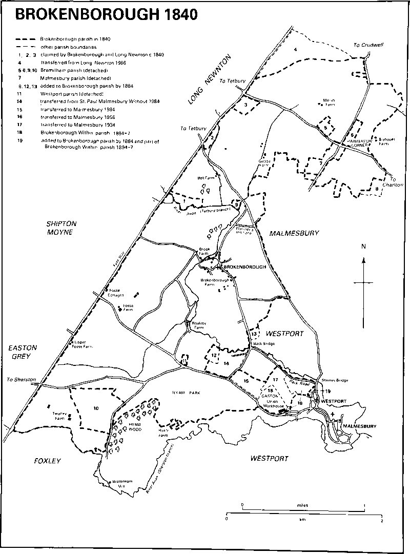
Brokenbrough 1840
Boundaries of what the abbey claimed had been its Brokenborough estate in 956 were drawn up in the 11th or 12th century and took in, among others, lands later in the parishes of Ashley and Long Newnton (both now Glos.), Crudwell, Malmesbury, and Westport. The only parts to have been later boundaries of Brokenborough parish were the Sherston Avon and, between that and the Tetbury (Glos.) branch of the Avon, the Foss Way. (fn. 13) The rest of the parish boundaries are irregular and marked by prominent features only in short stretches. Until the 19th century they were ill defined and uncertain, presumably because in the Middle Ages the tithes from Brokenborough and nearly all its neighbours were due to Malmesbury abbey, and after the Dissolution many were in lay hands and merged. (fn. 14) The parish lies north east and south-west and is separated from Malmesbury by Westport parish. (fn. 15) It encompassed several islands of neighbouring parishes, (fn. 16) presumably because those lands and their tithes had been acquired by the lords of neighbouring manors. The lord of Bremilham manor held land in the open field of Brokenborough in the earlier 13th century: (fn. 17) in 1731 his successor owned 97 a. of Bremilham parish in three pieces surrounded or almost surrounded by Brokenborough, (fn. 18) and c. 99 a. in four pieces in 1840. (fn. 19) The lords of Whitchurch and Milbourne manor in Malmesbury and of Thornhill manor in Westport held land or tithes in Brokenborough in the 16th century, (fn. 20) and detached portions of both parishes, c. 30 a. in all, were encompassed by Brokenborough in 1840. (fn. 21) In 1371 and 1534 a field called Worthy, sometimes said to be in Brokenborough, Westport, and Malmesbury, (fn. 22) in 1478 land on the north side of the Tetbury Avon near Malmesbury, (fn. 23) and in 1577 Bremilham Mill on the Sherston Avon (fn. 24) were ascribed to Brokenborough: none was later. In the later 16th century land called Wakely Hill was disputed between Brokenborough and Milbourne; (fn. 25) mounds marked off Brokenborough from Long Newnton in 1584, (fn. 26) suggesting that part of the boundary was not then the Foss Way; and in 1649 and 1785 Hyam park was said to be partly in Brokenborough and partly in Westport. (fn. 27) The boundary between the two parishes was drawn across Hyam park in 1838: Hyam Farm and Hyam wood were assigned to Westport, a field called the Gaston, c. 25 a. near Malmesbury on which the union workhouse was built in 1838, was assigned to Brokenborough. (fn. 28)
In 1840 the parish was bounded on the south by the Sherston Avon and the new boundary of 1838, already slightly amended, and on the north-west by the Foss Way: watercourses and roads also marked some of the northern and eastern boundaries. At its south-east corner the parish adjoined the built-up area of Malmesbury and Westport. (fn. 29) Between 1840 and 1884 several fields on Brokenborough's irregular eastern boundary, of which one was the site of Malmesbury fever (isolation) hospital between the 1890s and 1933 and others took Brokenborough's boundary eastwards along Burnham Road and to the north-west side of Shipton Hill in Westport, a total of c. 13 a., were transferred to Brokenborough from Westport, and a detached ½ a. of Brokenborough beside Park Road surrounded by Westport was transferred to Westport; and in 1884 the islands of Malmesbury, Westport, and Bremilham, a total of c. 130 a., were transferred to Brokenborough. (fn. 30) Three fields adjoining the east side of the Foss Way but not each other, a total of 32 a. belonging to the lord of Long Newnton manor, were claimed by both Brokenborough and Long Newnton c. 1840. (fn. 31) They were ascribed to Long Newnton in 1881, and in 1889 Brokenborough measured 2,634 a. (fn. 32) From 1872 two parts of the south-east corner of the parish, c. 19 a., were in Malmesbury urban sanitary district, from 1886 Malmesbury municipal borough. (fn. 33) In 1894 they and the lands between Foundry Road and Burnham Road and on the north-west side of Shipton Hill became a separate parish called Brokenborough Within, and from then the remainder of Brokenborough parish was called Brokenborough Without. In 1897 Brokenborough Within was merged with Westport St. Mary Within, and Brokenborough Without was again called Brokenborough. (fn. 34) A further 25 a. at the south-east corner were transferred to Malmesbury municipal borough in 1934, (fn. 35) and a further 25 a., the Gaston, on which the workhouse stood, in 1956. (fn. 36) The three fields ascribed to Long Newnton in 1881, a further 76 a. of Long Newnton adjoining the Foss Way to the west and Brokenborough to the south, and the width of the Foss Way itself were transferred to Brokenborough in 1966. (fn. 37) After that Brokenborough measured 1,085 ha. (2,681 a.). (fn. 38) In 1984 a further 9 ha. at the south-east corner were transferred to Malmesbury and 12 ha. of St. Paul Malmesbury Without parish were transferred to Brokenborough. (fn. 39)
The land is undulating, highest at over 110 m. in the north, lowest at below 76 m. in the south-east. It drains mainly to the Tetbury Avon which flows from north-west to south-east across it. There is flat land in the north and west crossed by the Foss Way, and the site of an airfield on the watershed of the Thames and the Bristol Avon is in the north. To the south and east the Tetbury Avon, called the Ingelbourne in the 11th or 12th century, (fn. 40) has cut the steep sided valley to which the parish name may refer. To the north and west the outcrops are mainly limestone and clay of the Forest Marble, to the south mainly Kellaways Clay and Cornbrash. Sand and gravel lie in various parts and the streams have deposited alluvium. There are several geological faults. (fn. 41) Nearly all the land is suitable for either tillage or pasture with, especially in the south, meadow land beside the streams. (fn. 42)
The principal roads through the parish, converging on Malmesbury from Sherston and Tetbury, were turnpiked in 1756. (fn. 43) Until c. 1778 the Tetbury road was part of the route between Cirencester (Glos.) and Malmesbury. (fn. 44) The Sherston road and a road which branched from it to Shipton Moyne (Glos.) were possibly made on their present routes at inclosure c. 1640. (fn. 45) Across the north end of the parish the Charlton—Tetbury road, called New Leaze Lane in 1639, (fn. 46) was turnpiked in 1798; (fn. 47) where it enters Brokenborough from the east the land was called Hankerton Corner from c. 1613 (fn. 48) or earlier. The Malmesbury—Tetbury road was disturnpiked in 1874, the other roads in 1876. (fn. 49) Brokenborough village is served by a road which links it to the Tetbury road and to Malmesbury: to the south the road crosses the Tetbury Avon and the parish boundary at Back bridge, and where it marked the parish boundary nearer Malmesbury is called Park Road. Of other roads in 1773 two, that linking the north part of Brokenborough village with the Shipton Moyne road, and Warmer's Inn Lane north of Brokenborough village, remain tracks; a road across the north end of the parish from the west end of Crudwell parish to Malmesbury, and a road from the Back bridge road to the Tetbury road went out of use between 1840 and the early 1880s. (fn. 50)
Brokenborough's assessment for taxation is likely to have been low in 1334 when it was returned with Burton Hill in Malmesbury, (fn. 51) but at 120 the number of poll-tax payers in 1377 was high. (fn. 52) The parish was of average wealth in the 16th century (fn. 53) and was later not densely populated: 75 adults lived in it in 1676. (fn. 54) In 1801 the population was 211: it had risen to 283 by 1831. Of 429 inhabitants 131 lived in the union workhouse in 1841, 160 of 443 in 1851. A decrease in the population from 503 in 1861 to 444 in 1871 was attributed to emigration. The population was 381 in 1891. In the three years of its existence Brokenborough Within had c. 60 inhabitants. Brokenborough's population was 317 in 1901 and 1951: a sharp rise to 388 between 1901 and 1911 was possibly caused by increased use of the workhouse or the isolation hospital. The land transferred to Malmesbury in 1934 had a population of 5 in 1931. (fn. 55) New building west of Malmesbury after the Second World War was partly in Brokenborough, and the land transferred to Malmesbury in 1956 had a population of 80 in 1951. Further building for Malmesbury in Brokenborough's south-east corner caused Brokenborough's population to reach 413 in 1961 and 556 in 1971. In 1981 it was 532: (fn. 56) away from Malmesbury the parish was sparsely populated.
Brokenborough village is on high ground near the Tetbury Avon roughly in the middle of the parish. To the south the farmsteads called Twatley in 1640 (fn. 57) and Boakley in 1678, (fn. 58) each beside a branch of the Avon, may be on old sites, but in the Middle Ages there seems to have been little settlement outside the village. Following inclosure five new farmsteads were built in the west and north in the 18th century or early 19th and it is very likely that house sites in the village were given up then. (fn. 59) In 1989 the village remained small.
In the village, centred on the church, most of the older buildings are of local stone. In the Middle Ages extensive demesne farm buildings belonging to Malmesbury abbey stood to the south slightly away from the village. A late-medieval barn of 10 bays with 2 east transeptal entrances, 9 raised cruck trusses, and walls with plain buttresses survives. A larger and possibly earlier barn and a farmhouse stood on a moated site south of it until demolished in the mid 17th century. (fn. 60) The demesne land was later worked from Brokenborough Farm at the south end of the village street. (fn. 61) The farmhouse has an apparently 17th-century north range of two storeys and attics to which a south wing was added in the 18th century. Respectively north-west and west of the church, Brook Farm and another house are 18th-century farmhouses extended in the 19th century. In the street are a house apparently of the 17th or 18th century and two small farmhouses and a cottage apparently of the 18th. North of the church a small farmhouse was much enlarged and altered in the later 20th century. South of the church the Rose and Crown is a small 18th-century house extended in the 19th century: it was called the Crown in 1731, (fn. 62) the Rose and Crown in 1740. (fn. 63) In the street 11 houses are 20th-century: they include 4 council houses built in 1954, (fn. 64) a large house of the 1960s, and 2 stone houses built as a pair c. 1980. (fn. 65) Along the street sites from which buildings have been removed are evident.
Outside the village Boakley is the oldest farmhouse. (fn. 66) It was built in the later 17th century with a staircase in a semicircular rear projection, and a rear wing was added in the 19th century. From 1773 or earlier some of the farm buildings have been on a higher site further south (fn. 67) where an apparently 18th-century barn survives, and a new house was built further south in 1961. (fn. 68) Upper Fosse Farm is a small early 18th-century house, extended in the early 19th century westwards and by the addition of a rear north wing. Fosse Farm is an L-shaped house of the early or mid 18th century extended to form a square in the 20th: its symmetrical south front has a stone doorcase and rusticated quoins. Gilboa Farm is also 18th century, Bell Farm is of c. 1800, Marsh Farm is of the early 19th century, and Boakley Cliff Farm is mid 19th-century. Beside the Foss Way an apparently 18th-century house, possibly that called Red Lion House in 1773, (fn. 69) later Fosse Cottages, (fn. 70) was rebuilt in 1938. (fn. 71) At the junction of the road through the village and the Tetbury road, an area called Sunset Hill in 1919, (fn. 72) are a 19th century house and a pair of cottages of the early 20th. Beside the Sherston road a row of 10 estate cottages was built in vernacular style with gabled stone roofs mainly in the period 1919–40, (fn. 73) and beside each of the Tetbury road, the Charlton— Tetbury road, and the Sherston road a pair of estate cottages was built c. 1900. A public house beside the Sherston road was called the Bull in the early 1880s, the Red Bull in 1899 (fn. 74) and 1987.
The workhouse was the only building in the south-east corner of the parish in 1840, (fn. 75) but others may have been erected by 1872 when Malmesbury urban sanitary district took in two pieces of land. In 1884 those lands had on them a bacon curing factory beside Park Road and buildings in Burnham Road, at the north-west end of Foundry Road, and at the south end of Bremilham Road. The land on the north-west side of Shipton Hill and between Foundry Road and Burnham Road transferred to Brokenborough by 1884 then had on it houses, cottages, and industrial buildings in Foundry Road and Shipton Hill and the police station in Burnham Road. A large house, Burnham House, was built in Burnham Road between 1884 and 1899. (fn. 76) Other houses to be built on what was Brokenborough Within include cottages in Burnham Road, council houses at the east end of Athelstan Road, at the east end of Pool Gastons Road, and in Hobbes Close, an estate of private houses on the site of the bacon factory near Staines bridge, and private houses in St. Aldhelm's Road and at the east end of Old Alexander Road.
On the 25 a. transferred to Malmesbury in 1934 eight council houses were built in Pool Gastons Road in 1932. (fn. 77) Other council houses were later built in the same road, at the west end of Athelstan Road, in Avon Road, Alexander Road, Newnton Grove, and near the swimming pool built in 1961. (fn. 78) To the north, part of the housing estate called White Lion Park was built. (fn. 79) On the 25 a. transferred to Malmesbury in 1956 the workhouse, closed in 1933, (fn. 80) was converted in 1937 and 1938 to 20 houses called Bremilham Terrace, (fn. 81) a total of 58 council houses was built in Corn Gastons in 1954 and 1956, (fn. 82) Malmesbury secondary modern school was built in 1954, (fn. 83) and council houses in Bremilham Rise later replaced Bremilham Terrace. (fn. 84) On the 9 ha. transferred to Malmesbury in 1984 the Parklands estate of 34 council houses and 21 old people's bungalows was built in 1958, (fn. 85) c. 30 sheltered homes for old people were built in 1965, (fn. 86) and 26 council houses and 28 old people's bungalows were built in 1968. (fn. 87)
Long Newnton airfield, half in Brokenborough, was laid out as a decoy for Kemble airfield in 1940, and almost immediately began to be used to train for night flying. In 1941 it had two runways, a perimeter track, and four hangars, and more hangars were built in 1942. The airfield was used only for storage after 1945: most later reverted to agriculture but a few buildings, including the control tower, survived in 1987. (fn. 88)
Manor and other Estates.
In 1086 Malmesbury abbey held a 50-hide estate called Brokenborough. The abbey later claimed that an estate of 100 mansae called Brokenborough was granted to it by King Edwy in 956 and that in 1065 King Edward confirmed to it a 50-hide estate called Brokenborough. The estate in 1086 included Corston in Malmesbury, is likely to have included Bremilham, Cowfold in Malmesbury, and Grittenham in Brinkworth, and possibly included Rodbourne in Malmesbury, Sutton Benger, and lands later in Westport parish: of all those only Corston was mentioned in Domesday Book. The abbey claimed that the estate in 1065 included Bremilham, Corston, Cowfold, Grittenham, Rodbourne, and Sutton Benger; the boundaries appended to what it claimed was a copy of Edwy's grant of 956 took in much more of its 13th century Wiltshire estate, but omitted part of it alienated in the late 11 th century. It is doubtful that Edwy and Edward made grants in the terms cited by the abbey, (fn. 89) and very likely that the abbey held Brokenborough village, its land, and other nearby land from or soon after the abbey's foundation. In 1086 the places included in the large estate called Brokenborough may have been separate entities, as they all were later. The manor of BROKENBOROUGH was held by the abbey until the Dissolution. (fn. 90) In 1552 the king gave the manor, except a meadow and some woodland, to John Dudley, duke of Northumberland, in an exchange, (fn. 91) and in 1553 Northumberland sold it to Sir James Stumpe, (fn. 92) the owner of Charlton manor and other of Malmesbury abbey's estates. The Crown granted the excepted lands to Stumpe through an agent in 1559. Stumpe (d. 1563) settled Brokenborough on his wife Isabel (fn. 93) (d. 1573), later wife of Thomas Stafford: (fn. 94) the conveyance was found to be imperfect and in 1565 his trustees leased the manor to the Staffords. Stumpe had a daughter Elizabeth (d. 1585), wife of Henry Knyvett (knighted 1574, d. 1598), and in 1566 the trustees conveyed the manor to the Knyvetts. (fn. 95) From 1598 to 1987 Brokenborough descended with Charlton manor in the Howard family and with the earldoms of Suffolk and Berkshire. (fn. 96) The manor included c. 2,200 a. c. 1840; (fn. 97) 155 a. of Twatley farm were sold in 1857, (fn. 98) c. 220 a. of Hyam farm were sold between 1912 and 1927, (fn. 99) and Marsh farm, c. 260 a., was sold c. 1985. In 1987 the Charlton Park estate owned 1,548 a. in Brokenborough parish. (fn. 100)
In the late 12th or early 13th century Malmesbury abbey granted 1 yardland in Brokenborough to be held freely by Wibert son of William. (fn. 101) In 1242–3 William le Theyn held an estate there assessed as 1/10 knight's fee. (fn. 102) William apparently had a son Miles whose son Geoffrey le Theyn claimed land in Brokenborough against relatives in 1249. (fn. 103) Other members of the Theyn family held land in Brokenborough in the 1260s but apparently not after 1268 when William Theyn conveyed an estate there and in Charlton to Roger Charlton. (fn. 104) The land in Brokenborough descended with that in Charlton in the Charlton family, of which Wibert son of William may have been a member. (fn. 105) It belonged to Robert Charlton (fl. 1387), (fn. 106) Walter Charlton (d. by 1444), (fn. 107) Wibert Charlton (fl. 1454), (fn. 108) and John Charlton. In 1478 John sold it to Sir Roger Tocotes (fn. 109) (d. 1492). (fn. 110) Tocotes may have settled it on his wife's son Sir Richard Beauchamp, Lord St. Amand, whose son Anthony St. Amand (fn. 111) may have held it in 1526. (fn. 112) About 24 a. of it apparently passed with the Charlton land to the Long family of Draycot Cerne and was merged with Brokenborough manor in the early 17th century. (fn. 113) The rest of the estate was apparently bought in 1535 by William Stumpe from another Roger Tocotes. (fn. 114) Stumpe (d. 1552) was succeeded by his son Sir James Stumpe (fn. 115) (d. 1563), and his part of the estate, 88 a. in 1558, (fn. 116) passed with Brokenborough manor to Henry and Elizabeth Knyvett, (fn. 117) who conveyed it to Sir James's brother John in 1564. (fn. 118) John Stumpe (d. 1600) held other lands in Brokenborough. (fn. 119) What had been Sir Roger Tocotes's was apparently what became FOSSE, (fn. 120) later Upper Fosse, farm. It passed to Stumpe's son James (d. 1602) and to James's son William, a minor in 1602, (fn. 121) who was presumably the William Stumpe who held the land in 1644. (fn. 122) Thomas Stumpe held it in 1671 (fn. 123) and 1680. (fn. 124) Fosse farm belonged to William Robins in 1737. In 1760 Anne Robins, a widow, sold it to Mary Pitt (fn. 125) (d. by 1829), a widow, later wife of Stiles Rich. It passed to Mary Pitt's grandson Alfred Pitt who sold the farm, 60 a., to Thomas, earl of Suffolk and of Berkshire, in 1837. (fn. 126) It was absorbed by Brokenborough manor.
In 1242–3 John Mautravers held land in Brokenborough assessed as ¼ knight's fee. (fn. 127) An estate, assessed as ¼ knight's fee in 1428 (fn. 128) and possibly the same, was conveyed in 1340 by Sir John Mauduit to his son-in-law John Moleyns (d. 1360), (fn. 129) who in the same year was granted free warren in the demesne lands. (fn. 130) The estate descended in the Moleyns, Hungerford, and Hastings families with Lea manor to Henry Hastings, earl of Huntingdon, (fn. 131) who sold it to Anthony Webb in 1571. (fn. 132) Webb apparently sold the estate, c. 42 a., to William Bailey in 1593. (fn. 133) Bailey (d. 1621) had a son Giles (fn. 134) (d. 1645 or 1646) who devised land in Brokenborough to his grandsons Giles Bailey and Anthony Bailey. (fn. 135) In 1655 Anthony Bailey held the land later called BOAKLEY farm, c. 88 a. (fn. 136) Later owners of the farm were said to be Giles Bailey, Daniel Bennett (fl. c. 1758), Daniel's son Giles (fl. 1780), Giles Bailey Bennett (fl. 1810), and Daniel's grandson Daniel Bennett of Faringdon House (Berks., now Oxon.). (fn. 137) The farm, 90 a., was for sale in 1816. (fn. 138) Sarah Godwin owned it in 1839, (fn. 139) H. F. Gibson in 1910, (fn. 140) and the Misses Geneste in 1928. (fn. 141) In 1934 it was bought from the Genestes by J. E. Baldwin (d. 1982), members of whose family, including his son Mr. E. J. Baldwin, owned the farm, c. 130 a., in 1987. (fn. 142)
In the early 15th century John West, a prominent local official, may have held land freely in Brokenborough, (fn. 143) as another John West did in the early 16th century. The later John's son Henry held c. 180 a. which he sold to William Stumpe (d. 1552) in 1551–2. Stumpe's son Sir James (fn. 144) (d. 1563), the owner of Brokenborough manor from 1553, leased WEST'S to West (d. c. 1557) and his wife Anne (fl. 1570) for life. In 1564 Anne and her husband Thomas Feltham disputed the freehold with Sir James's daughter Elizabeth and her husband Henry Knyvett. (fn. 145) The Knyvetts apparently held it in 1581, (fn. 146) and in 1622 John Morley, Henry West's grandson, quitclaimed to their grandson Thomas, Lord Howard. (fn. 147) The estate, which may have included the site of Twatley Farm, was absorbed by Brokenborough manor. (fn. 148)
Several small estates in Brokenborough held freely in the Middle Ages included one conveyed by Thomas of Purton to Adam Sturmy (fn. 149) who apparently held it in 1236. (fn. 150) Purton gave a rent of 2s. from it to Bradenstoke priory. (fn. 151) Robert Sturmy of Seagry, who had a son Adam, conveyed 1 yardland in Brokenborough, possibly the same land, to Thomas Goter in 1311. (fn. 152) Possibly in the early 13th century, certainly from the late 13th, land in Brokenborough was part of an estate centred on Purton: (fn. 153) in 1421 some was part of a manor called Gascrick, (fn. 154) and in 1476 some, with land in Purton, was given to endow the Wootton and York chantry in Ramsbury church. The chantry was apparently dissolved c. 1539. (fn. 155) Another estate was held by John Malliard (d. 1534) whose son Thomas (fn. 156) in 1546 sold it to Matthew King (fn. 157) (fl. 1570). (fn. 158) Land belonged to St. Mary's chantry in Westport church in 1478: (fn. 159) what was said to be that land was acquired by King from Henry and Elizabeth Knyvett in 1564. (fn. 160) King's land was acquired by his son-in-law John Stumpe in 1571 (fn. 161) and passed with Stumpe's other land. (fn. 162)
From 1249 or earlier to 1928 land in Brokenborough was part of Bremilham manor, as were the detached parts of Bremilham parish encompassed by Brokenborough until 1884. In 1249 the lord of Bremilham held 36 a. in the open fields, (fn. 163) a total of 51 a. c. 1600 (fn. 164) and of 64 a. in 1897. (fn. 165) In the 16th century and early 17th other freeholds in Brokenborough parish included a total of c. 85 a. (fn. 166) Some of that descended with Foxley manor, (fn. 167) some with Whitchurch and Milbourne manor in Malmesbury. (fn. 168)
TWATLEY farm was bought in 1857 by T. G. Smith (fn. 169) (d. 1908), from 1871 the lord of Easton Grey manor. Smith's heir was his sister Honora (d. 1916), wife of the Revd. George Wilder, and members of the Wilder family owned the farm in 1910. It was bought c. 1925, possibly from Honora's son and heir Graham Wilder, by H. C. Cox (d. c. 1945). (fn. 170) Cox, a Canadian, deputy master of the Beaufort hunt, until 1939 lived at Twatley mainly in the winter: he used the estate as a base from which to hunt and added more land to it. (fn. 171) The farmhouse, later called Whatley Manor, was apparently rebuilt in the 18th century. Presumably between 1857 and 1871 it was enlarged by incorporating or replacing a range of outbuildings to the north-west. (fn. 172) R. R. Neeld lived in the house in the period 1899–1924 or longer. (fn. 173) Cox altered the inside and added a west wing. He greatly extended the stable court, built other stables and coach houses, and laid out ornamental gardens and a small park. On the Sherston road Smith built the east lodge, Cox the west lodge. (fn. 174) Cox's executors sold the estate to H. I. Coriat and his wife Priscilla, who owned it until c. 1957. (fn. 175) It later belonged to R. J. Rennie who c. 1961 divided it. In 1987 Whatley Manor was a hotel and Twatley Manor farm, with buildings converted from some of Cox's stables and coach houses, belonged to Mr. J.E. Willis. (fn. 176)
Malmesbury abbey owned the tithes from Brokenborough, (fn. 177) and after the Dissolution they were part of Brokenborough manor. (fn. 178) When the tithes were commuted in 1840 Thomas, earl of Suffolk and of Berkshire, owned nearly all the land and great tithes of the parish. Great tithes on their own land, a total of 23 a., were owned by John Hill and George Woodruffe. Great tithes owned by the rector of Bremilham from 117 a. and by Thomas and Mary Anne Gaby from 12 a. were commuted. (fn. 179)
Economic History.
Malmesbury abbey's large estate called Brokenborough was assessed at 50 hides in 1086; what became Brokenborough parish may have been 14. With 64 ploughteams on land for 60 the estate was fully exploited, mostly by villani, and there was a small proportion of demesne. There were 8 mills, 50 a. of meadow, 30 a. of pasture, and woodland 3 leagues by 2, but Brokenborough village is likely to have had a small proportion of them. (fn. 180) In 1210 its Brokenborough estate was the abbey's most valuable, and, with 64 oxen, was stocked for arable farming: the very high value suggests that land elsewhere was accounted for with Brokenborough's. (fn. 181)
In the early 13th century Brokenborough's arable and pastures were clearly open, and between then and the earlier 18th century they were inclosed by stages. Between 1222 and 1246 inhooks were proposed and probably made, with corn sown on temporarily inclosed fallow which would otherwise have been common pasture for sheep. The lord and tenants of Bremilham then had land and pasture rights in the open field. (fn. 182) In the late 14th century the land of Brokenborough remained open. (fn. 183) Although there was a Little field in 1369, (fn. 184) most arable was in two apparently roughly equal fields, called West and North in 1249. (fn. 185) There were common pastures, and both meadow land and woodland were apparently commonable. Malmesbury abbey's demesne was the largest holding (fn. 186) but between them the customary tenants, c. 27 in 1284, may have held much more land. The customary works by tenants may have been enough to cultivate the demesne (fn. 187) which in 1396 included 180 a. of arable and 15 a. of meadow and had on it 4 avers, 24 oxen, 2 cows, and 200 sheep. (fn. 188) Later evidence shows that the customary tenants of Brokenborough had to provide 21 mowers and 21 haymakers for each of two demesne meadows, a total of 28 a., and 4 of each for a third, 3 a. Customary tenants from Sutton Benger helped to mow the two meadows. (fn. 189) A large barn was built on the demesne in the late 13th century, (fn. 190) another in the late Middle Ages, (fn. 191) and a farmhouse called the place house was referred to c. 1600. (fn. 192) In 1478 the arable strips of the demesne, customary tenants, and freeholders were apparently intermingled, and by then the demesne had apparently been leased. (fn. 193) In the early 16th century most of it was leased as a single farm; some meadow lands and the woodland and warren of Hyam which may have been in Westport parish, were leased separately. In 1539–40 the c. 20 customary holdings, some of 2 or more yardlands, totalled c. 20 yardlands (fn. 194) and the c. 6 freeholds possibly totalled c. 10 yardlands. (fn. 195)
The common pastures of Brokenborough were possibly in the extreme north and extreme south-east. They had been inclosed by the mid 16th century. (fn. 196) That in the south-east, Gaston, may have been c. 75 a.; (fn. 197) evidence of c. 1613 shows that in the north, called New leaze after inclosure, to have been 150–200 a. (fn. 198) At inclosure New leaze was divided, and allotments, mainly of between 5 a. and 15 a., were added to most holdings. (fn. 199) Other land, especially parts of the demesne and freeholds, was in closes in the 16th century; (fn. 200) in the 1570s Hyam park, partly in Brokenborough, was enlarged, (fn. 201) and c. 1600 formerly common meadows were apparently several. (fn. 202) Most arable, however, remained open and in West and North fields. There was still a small third field, called South in 1558 and later, but few held land in it. Cultivation in West and North fields was apparently in small strips, (fn. 203) and in the 16th century small parts of both fields were used as meadow. (fn. 204) Other parts, in which the demesne lay, may have been inclosed in the later 16th century. (fn. 205) Feeding in the fields was supervised by the manor court, and in 1580 the homage met to consider a proposal to inclose West field. Sheep were usually stinted at two for each acre held. (fn. 206) About 1613 West field and North field were each c. 425 a.; a further 116 a. of West and 25 a. of North were said to have been inclosed. (fn. 207) Nearly all of both fields was inclosed between then and c. 1700. Newly inclosed lands and the inclosure process were frequently mentioned in the mid 17th century, (fn. 208) but there is no evidence of formal agreement. In the 1660s John Aubrey referred to much recent, and continuing, inclosure at Brokenborough, a new preference for wheat to barley, and conversion of arable to pasture. (fn. 209) There were 200 a. or more of open field in 1672, (fn. 210) but after c. 1700 apparently only a small and fragmented residue survived. (fn. 211) From then until the later 20th century nearly all the parish was a patchwork of closes averaging c. 10 a. (fn. 212)
Although Brokenborough was outside Braydon forest at every perambulation, (fn. 213) rights to wood and pasture in the forest or its purlieus were claimed in 1570 or earlier by the tenants of Brokenborough manor: (fn. 214) the claims possibly originated in some by Malmesbury abbey for its whole estate. Cattle were driven from Brokenborough to be turned into the purlieus at Stonehill in Charlton. They were not restricted to any part of the forest or purlieus and were not stinted. (fn. 215) In 1576 the manor court ordered the tenants to appoint a herdsman to keep their cattle in the forest for a fortnight in September. (fn. 216) In Charlton quarter Brokenborough manor was said to have woodland within a 2-mile perimeter, in 1590 said to be 100 a., and 4 a. of heath, presumably a clearing. (fn. 217) Braydon was disafforested in 1630, and in 1631 Thomas, earl of Berkshire, lord of Brokenborough manor and other manors nearer the forest, inclosed parts of the purlieus in respect of all those manors, (fn. 218) but apparently none was added to any farm in Brokenborough.
Until the 18th century it seems that nearly all the farms in the parish were based in Brokenborough village: Twatley and Boakley were the exceptions. (fn. 219) The demesne, which in 1556 included a total of 280 a. in West and North fields, had been leased in portions by 1590. The largest portion, Brokenborough farm, was c. 290 a. c. 1600 when it included only 33 a. of open field. Hyam park, c. 201 a. in Brokenborough and Westport in 1649, was still leased separately, and by 1590 farms of 80 a. and 50 a., mainly in the open fields, had apparently been made from the demesne. In 1590 most of the c. 23 copyholds and c. 6 freeholds included land in each main open field and an allotment of New leaze. (fn. 220) A total of c. 990 a. was copyhold c. 1613, of c. 310 a. freehold. Apart from Brokenborough farm there were some 25 farms in the parish averaging c. 50 a. with only one exceeding 100 a., (fn. 221) and that was the pattern of tenure throughout the 17th century and in the early 18th. (fn. 222)
In the 18th century new farmsteads were built on inclosures outside the village. Those called Fosse, Upper Fosse, and Gilboa were built between 1700 and 1773, and those called Marsh and Bell between 1773 and 1820. (fn. 223) In the later 18th century the farms were reorganized and made fewer. (fn. 224) As part of an attempt to improve the Charlton Park estate John, earl of Suffolk and of Berkshire, in 1809 advertised, apparently in vain, for tenants from Northumberland and Scotland for seven farms in Brokenborough: it was intended to increase arable and introduce mechanical threshing. (fn. 225) About 1840 there were 817 a. of arable and 1,772 a. of grassland in the parish in 10 main farms. Based in the village Brokenborough farm, 530 a., was half arable and half pasture, and Brook farm, 52 a., was mostly pasture. Twatley farm, 302 a., was also half arable and half pasture, but Boakley, c. 100 a., Bell, 140 a., Gilboa, 269 a., and Marsh, 263 a., were predominantly pasture. Upper Fosse farm, then called Butts, and Fosse farm, a total of c. 220 a., were worked together. In the north-east 162 a., more arable than pasture, were in Bishoper farm based in Hankerton; in the south 240 a., mostly pasture, were in Hyam farm based in Westport. (fn. 226)
More of the parish was converted to grassland between the mid 19th century and the early 20th. The farms based in the parish included c. 650 a. of arable in 1887, only c. 350 a. in 1937. In 1887 they had on them 147 cows, 257 other cattle, 581 sheep, and 143 pigs; 315 cows, 168 other cattle, 432 sheep, and 74 pigs in 1937. (fn. 227) By 1910 land had been taken from Brokenborough farm, then 254 a., to enlarge Brook, then 281 a. Fosse farm was then 238 a., Upper Fosse 163 a., Bell 121 a., Marsh 263 a., Gilboa 236 a., and Boakley c. 100 a. Between 1857, when it was 153 a., and the mid 1920s Twatley farm may have been used as much for sport as agriculture. In 1910 Bishoper farm and Hyam farm still included a total of c. 400 a. in the parish, and Cowage (Bremilham) farm 64 a. (fn. 228) In 1920 Boakley Cliff was a small dairy farm. (fn. 229)
The pattern changed again in the 1960s and 1970s. Much land was taken in hand as part of the Charlton Park estate, much pasture was ploughed, and the average size of the fields was greatly increased. In 1987 c. 1,350 a. of Brokenborough parish were worked with land in Charlton by that estate from Brokenborough Farm and buildings near Charlton Park: a large new grain store stood at the junction of the road through the village and the Tetbury road. There was pasture in the east and a dairy at Brokenborough Farm, but in most of the west and north cereals were grown. Bishoper farm included c. 200 a., mostly arable, in the parish, (fn. 230) and Marsh farm, c. 260 a., was also mainly arable. Boakley was a mainly dairy farm of c. 130 a., (fn. 231) and Hyam still included c. 200 a., mainly pasture, in the parish. (fn. 232) The Twatley estate was used mainly to feed horses from c. 1925 to c. 1945. In the later 20th century Twatley Manor farm was worked from converted stables and coach houses of Whatley Manor and included land in Easton Grey. (fn. 233)
Brokenborough parish never seems to have contained much woodland. Hyam and Twatley were woods in the early 13th century (fn. 234) and the 16th. (fn. 235) Later the woods of Hyam park were assigned to Westport parish (fn. 236) and Twatley farm contained no woodland. (fn. 237) In 1840 there were 4 a. of woodland in the parish, (fn. 238) and in the later 20th century several small plantations were made. (fn. 239)
In the later 13th century three mills may have been part of Brokenborough manor. (fn. 240) One, still held freely as part of the manor in the 16th and 17th centuries, was Bremilham Mill in Westport. (fn. 241) A water mill was held by copy in the 16th century, (fn. 242) by lease in the 17th: (fn. 243) it may have been near Back bridge, (fn. 244) either in Brokenborough parish or Westport. No certain site of a mill in Brokenborough parish is known.
It is unlikely that Brokenborough shared much in the Malmesbury cloth industry, but a weaver and a wool spinner were mentioned in 1349, (fn. 245) a broad weaver in the 1660s, (fn. 246) and a clothier in 1680. (fn. 247) A bacon factory, a slaughterhouse, and the Westport ironworks were on the land which was for three years Brokenborough Within parish. (fn. 248) In the late 1920s and the 1930s, and in the 1980s when it was an hotel, Whatley Manor provided employment in the parish. (fn. 249)
Local Government.
Malmesbury abbey had regalian rights in Brokenborough and in the later 14th century or earlier held view of frankpledge there. (fn. 250) In 1340 John Moleyns was granted liberties which included view of frankpledge, (fn. 251) but neither he nor his descendants seems to have exercised them in respect of their Brokenborough estate. In the early 16th century the abbey held view of frankpledge with a manor court twice a year at Brokenborough: (fn. 252) in 1549 it was claimed that before the Dissolution it was attended by the men of Lea and Cleverton because no court was held at Lea. (fn. 253) No Lea business was done at Brokenborough after the Dissolution.
Court records from the mid 16th century to the early 19th survive for Brokenborough manor. (fn. 254) For most of that period courts called view of frankpledge with the court of the manor were held twice yearly, in spring and autumn. In the early part of the period the distinction between the two types of court was observed: a jury affirmed the tithingman's presentments and the homage presented manorial business. Later a single panel acted as jurors and homage. In the later 16th century and earlier 17th the taking of strays and of excess tolls by millers were frequently presented under leet jurisdiction. Less frequently unsworn males over 12 were ordered to take an oath of allegiance, participants in affrays and unlawful games were punished, and tapsters were amerced. Failures to practice archery and to keep bows and arrows were presented in the earlier 17th century, (fn. 255) as was misuse of greyhounds. (fn. 256) The homage presented deaths of tenants and surrenders of copyholds, misuse of common pastures, and buildings out of repair: the court made rules for common pasturage and fixed penalties for infringements, ordered repairs to boundaries, gates, and watercourses, dealt with other copyhold and agrarian business, and elected officers. In 1579 a court punished a suitor for refusing to doff his cap and for other contumacy, (fn. 257) in 1625 an overseer of highways for neglect, (fn. 258) and in 1631 an inhabitant for idleness. (fn. 259) Open-field husbandry still gave rise to business in the courts in the later 17th century, as did the condition of hedges, ditches, and roads; but the business was becoming stereotyped and in the 18th century most business concerned copyhold tenure and the appointment of officers. Throughout the period courts baron in addition to the biannual court were occasionally held for copyhold business.
Brokenborough relieved its own poor. (fn. 260) The cost was £61 in 1775–6. It rose from £55 in the early 1780s to £282 in 1802–3, a rate of increase above average. Continuous relief was given to 26 adults, and occasional relief to 59, in 1802–3, to 21 and 12 respectively in 1812–13. The cost of poor relief was usually between £200 and £300 a year in the early 19th century but above £300 from 1816–17 to 1821–2 and in 1829–30 and 1830–1. Although the annual changes were smaller than in some parishes the cost of poor relief in Brokenborough was usually about average for a parish of its size. (fn. 261) The parish became part of Malmesbury poor-law union in 1835 (fn. 262) and of North Wiltshire district in 1974. (fn. 263)
Church.
Brokenborough church had apparently been built by the 12th century. (fn. 264) In 1248 it may have been served by Malmesbury abbey (fn. 265) which took the tithes of Brokenborough. (fn. 266) From 1341 or earlier to 1879 it was a chapel of Westport church, and from 1879 to 1984 a chapel of Charlton church. (fn. 267) In the early 16th century, because Brokenborough village was sometimes separated by flood water from Westport church, the bishop consecrated Brokenborough church for christenings and marriages and authorized burials. (fn. 268) Corpses were buried at Brokenborough in the 17th century and later. Marriages were apparently solemnized at Brokenborough in the 17th century and early 18th, but from c. 1744 only at Westport or Charlton. (fn. 269) Brokenborough church was licensed for marriages in 1933. (fn. 270) In 1984 a benefice, in the gift of the Church Trust Fund, and a parish of Brokenborough were created and united with those of Malmesbury with Westport: Malmesbury became the parish church. (fn. 271)
The vicar of Westport received moduses in respect of demesne land and of the part of Hyam park in Brokenborough. In 1784–5 he successfully claimed the full value of the small tithes from all the rest of the parish. The tithes were commuted in 1840. (fn. 272) There was no glebe in Brokenborough parish.
Until the Reformation the church contained a wheel of 18 small bells rung at the Elevation of the Host. (fn. 273) In 1380 the rector of Kellaways may have served Brokenborough, (fn. 274) and from the 16th century a curate served apparently more often than the vicar of Westport. (fn. 275) In the early 16th century the inhabitants of Brokenborough provided a lodging for a curate and agreed to add 33s. 4d. a year to the curate's stipend when one lived in Brokenborough, but there is evidence that none did for long. (fn. 276) The church lacked the Paraphrases of Erasmus in 1553 (fn. 277) and the parishioners implied in 1556 that their expectation of two Sunday services was not being met. (fn. 278) The early 17th-century curate Thomas Hobbes, father of the philosopher Thomas Hobbes, was not resident and the parishioners complained that too few sermons were preached. (fn. 279) In 1650 they again protested that the church was not well served, (fn. 280) and it was claimed in 1665 that no service was held on 12 consecutive Sundays. (fn. 281) In 1783 the vicar held a service on alternate Sundays, celebrated communion four times with c. 12 communicants, and catechized. (fn. 282) On Census Sunday in 1851 the afternoon service was attended by 61. (fn. 283) In the earlier 20th century a service was held every Sunday: communion was celebrated 16 times in 1910 and in 1953, 30 times in 1939. (fn. 284) From 1706 Brokenborough received £1 a year from the Lady Frances Winchcombe charity to buy Bibles and prayer books; in 1904 some of the income was spent on books for the Sunday school. (fn. 285)
The church of ST. JOHN THE BAPTIST, so called in 1763, (fn. 286) is of coursed rubble with limestone ashlar dressings and consists of a chancel with north vestry and a nave with north aisle and porch and east belfry. The nave, small and with thick walls, and the chancel, almost square, were apparently built in the 12th century or earlier. The aisle, with a four-bay arcade, was built c. 1200, and, possibly about then, the chancel arch was rebuilt. In the 14th century new windows were made in the east and south walls of the chancel and the south doorway of the nave was renewed. Apparently in the early 16th century, the date of its doorway and windows, the aisle was rebuilt, probably to a greater width. In the late 16th century or early 17th the only window in the south wall of the nave was heightened and given a dormer roof. The south doorway had been blocked and its porch demolished by the early 19th century. About 1800 the tall window was removed and a wooden belfry replaced or encased a stone bellcot. (fn. 287) The church was restored in 1883 (fn. 288) when much of the exterior stonework was renewed, the north porch was rebuilt, the vestry was added, and the roofs were renewed. An early 17th-century pulpit survives.
The church had 3½ oz. of plate in 1553. In 1987 it had a chalice hallmarked for 1651, a silver paten, and a silver-plated paten. (fn. 289) There were two bells and a sanctus bell in 1553. The single bell, cast by John Rudhall in 1801, was rehung in 1977 when the belfry was repaired. (fn. 290) The registers of baptisms and burials are complete from 1697: (fn. 291) marriages are recorded for the period 1709–44. (fn. 292)
Nonconformity.
In 1674 two men were presented for not attending church, (fn. 293) and a papist and a protestant dissenter lived in the parish in 1676. (fn. 294) Meeting houses for Independents were certified in 1815 and 1816. (fn. 295) A small chapel for Primitive Methodists was built in 1873 (fn. 296) and used until c. 1963. (fn. 297)
Education.
A day school was started in 1825 and was attended by 17 boys and 5 girls in 1833. Each year the Elizabeth Hodges educational charity gave £2 for three boys to be taught. (fn. 298) The school, attended by 20–30, was held in a cottage in 1858, (fn. 299) and in 1871 was attended by 12 boys and 21 girls. (fn. 300) Two buildings were used by schools in 1881, (fn. 301) and later a dame school for small children, to which the charity still paid £2, was held until the 1920s in a room adjoining the post office. (fn. 302) In the mid 19th century a school was held in the union workhouse in the south-east corner of the parish. (fn. 303)
Charity for the Poor.
None known.