A History of the County of Wiltshire: Volume 14, Malmesbury Hundred. Originally published by Victoria County History, London, 1991.
This free content was digitised by double rekeying. All rights reserved.
'Parishes: Crudwell', in A History of the County of Wiltshire: Volume 14, Malmesbury Hundred, (London, 1991) pp. 51-65. British History Online https://www.british-history.ac.uk/vch/wilts/vol14/pp51-65 [accessed 20 April 2024]
In this section
CRUDWELL
Crudwell village (fn. 1) is 6 km. north-east of Malmesbury. (fn. 2) It took its name either from the stream flowing through it or from the mineral spring south-east of the church. (fn. 3) Besides Crudwell village the large triangular parish, 1,983 ha. (4,899 a.), contains Eastcourt village and Chelworth, Murcott, Chedglow, and West Crudwell hamlets.
The boundaries of Malmesbury abbey's large estate called Brokenborough, which included Crudwell village and other parts of the parish, were described in the later 11th century or early 12th, but none has been convincingly identified with the later boundaries of Crudwell parish. (fn. 4) The boundaries of Chelworth, Murcott, and Eastcourt were described separately about the same time. Those of Murcott and Eastcourt included watercourses which may have been those later dividing Crudwell parish from Hankerton. Eastcourt's south-eastern boundary, Braydon or Swill brook, (fn. 5) was a boundary of Braydon forest in the 13th century and of its purlieus from 1300 until the forest was inclosed in 1630. In the early 1630s the purlieus were divided among the lords of manors adjoining them: c. 300 a. south-east of Braydon brook were allotted to the lords of Crudwell and Eastcourt manors and became part of the parish. (fn. 6) The parish's western boundary followed the Foss Way under an agreement of 1208 x 1222. (fn. 7) The eastern boundary with Oaksey, on its present course in 1591, follows a stream in the south and Quallstocks Lane in the north. (fn. 8) The southern boundary on Windmill Hill, earlier common to men of Crudwell and Hankerton, was defined only at the parliamentary inclosure of Hankerton in 1809. (fn. 9) In 1896 the north-eastern boundary with Kemble, and in 1930 the western one with Long Newnton and Ashley, became county boundaries when those parishes were transferred to Gloucestershire. (fn. 10)
Crudwell lies in the valley of the Upper Thames. (fn. 11) A feeder of Braydon brook flows southeastwards across the parish and two more rise south-west of Crudwell village. The highest land, at 135 m., is in the north, the lowest, below 90 m., in the south-east. Clay and limestone of the Forest Marble outcrop in most parts, Cornbrash around Eastcourt; nearly all the parish is suitable for both arable and pasture. Kellaways Clay and Oxford Clay outcrop in the south-east corner, where there is woodland, and there was formerly woodland further north-west around Chelworth. Across the north part of the parish oolite outcrops in a dry east—west valley and its three northern tributaries: it has been quarried in several places. (fn. 12) Alluvium has been deposited by Braydon brook and its feeders, extensively along the south-east boundary. The relief is gentle, and high ground in the north and south-west has been used for airfields.
The Foss Way along the western boundary remained the main Bath—Cirencester road until a more westerly road through Tetbury (Glos.) was turnpiked in 1743. (fn. 13) The Crudwell section of the Foss Way may have continued to take traffic from Cirencester to Malmesbury and Chippenham until 1778 when a new road was built to link Crudwell village and Five Lanes junction in Charlton as part of a Cirencester—Malmesbury turnpike road. That road was disturnpiked in 1874. (fn. 14) Only a very small part of the Crudwell section of the Foss Way has been made up. The Crudwell—Minety road was called London Way at Eastcourt in the mid 17th century, (fn. 15) and in 1773 as in 1989 crossed Braydon brook at Pill bridge. (fn. 16) It was turnpiked in 1810 and disturnpiked in 1864. (fn. 17) Until 1778 Malmesbury was reached from Crudwell village by Crudwell or Tetbury Lane leading west to the Foss Way or by a road leading through Murcott and Hankerton: both survive, but from c. 1825 the Murcott road has led from the Malmesbury road south of the village and not from the village itself. (fn. 18) A lane also links Crudwell to Ashley, and Tetbury Lane and Crudwell Lane lead on to Long Newnton and Tetbury. North of Crudwell village an eastwest road in the dry valley crosses the parish from Oaksey to Culkerton in Ashley: Tuners Lane links it to the west part of Crudwell village. In the east Quallstocks Lane, on its present course in 1591 (fn. 19) and only a path in 1989, and other lanes and footpaths have linked Eastcourt, Oaksey, Chelworth, and Kemble. The road between Crudwell and Kemble was improved c. 1937 when the Cirencester-Malmesbury road was diverted through Kemble to avoid a runway.
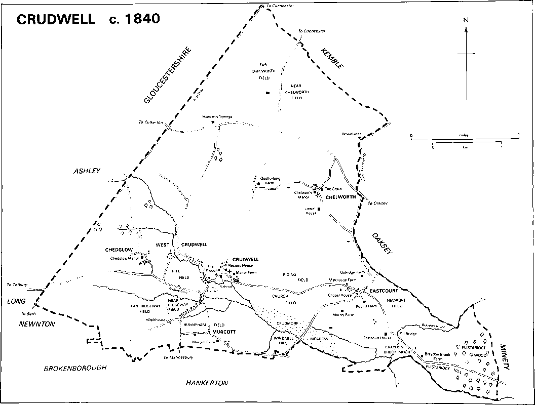
Crudwell c. 1840
Neolithic artifacts have been found in the parish, and a Bronze-Age bowl barrow may have been at Chedglow. Romano-British remains, including skeletons and coins at Murcott, have also been found. (fn. 20) No township in the parish was highly assessed for taxation in 1334. In 1377 the parish was apparently one of the most populous in the hundred: of 151 taxpayers 60 lived at Crudwell, 57 at Eastcourt, 20 at Chedglow, and 14 at Chelworth. (fn. 21) In the 16th century and earlier 17th Crudwell's assessments for taxation were among the highest in Malmesbury hundred. (fn. 22) The population fell from 512 in 1801 to 467 in 1811, but rose thereafter. Of the 681 inhabitants in 1841, 358 lived at Crudwell, 156 at Eastcourt, 58 at Chelworth, 55 at Chedglow, and 54 at Murcott. The population had risen to 799 by 1861, fluctuated in the period 1871–91, and fell to 574 in 1931. With the building of new houses after c. 1936 it rose again and was 924 in 1981. (fn. 23)
Crudwell church stands on a knoll, with the demesne farmstead east of it around the mineral spring and the rectory house west of it: Crudwell was an early endowment of Malmesbury abbey (fn. 24) and those sites were presumably used from the early Middle Ages. In 1230 the demesne farmstead included a hall, a large fishpond, and a chapel dedicated to St. Laurence. In the period 1260–96 the chancel of the chapel was reconstructed, the hall and fishpond were repaired, and new buildings, including a large stone-slated barn, two thatched barns, and two houses, were constructed. The farmstead was surrounded by a wall, the main gate of which still stood c. 1670. (fn. 25) It was apparently replaced in the 18th century or earlier by Manor Farm, in 1773 and 1820 called Paradise Farm, (fn. 26) a small farmhouse of stone rubble. A staircase was afterwards constructed in Manor Farm at the north end of its west side, and in the early 19th century the house was extended to the south-west by an L-shaped range with a symmetrical south front. The fishpond survived in 1989 when a large medieval barn was being made into a house. A church house may have stood near the church in 1597 and c. 1670, (fn. 27) and a school was built west of the church in the 17th century. (fn. 28)
Later settlement in the village was all west of the church, (fn. 29) where the older buildings are of stone, some with stone-slated roofs. In 1773 there were buildings in the Street and Tuners Lane but no more than one of those standing then survives. From 1778 the Street was part of the CirencesterMalmesbury road, more houses were built beside it, including a toll house at the junction with Tetbury Lane, (fn. 30) and the village was extended southwards. On the east side a terrace of cottages was built in the later 18th century and a terrace of neo-Gothic cottages in 1847. (fn. 31) On the west side the Plough inn, open in 1841, was built in the later 18th century and extended in the 19th; north of it Crudwell House, built in the earlier 19th century, (fn. 32) is of three storeys with an ashlared south front of three bays with a central Doric porch. Where a feeder of Braydon brook is forded at the junction of the Street and Tuners Lane is a small green, the cottages on the north and west sides of which in 1773 (fn. 33) were rebuilt in the 19th century. To the south Town Farmhouse was built in the early 19th century, (fn. 34) and the Wheatsheaf inn, open in 1859, (fn. 35) a nonconformist chapel, (fn. 36) and estate and other cottages were also built in the 19th century. The straightening of the road between c. 1960 and c. 1980 created a small green at the junction with the lane to Chedglow, (fn. 37) and more houses have been built there.
On the east side of Tuners Lane 4 pairs of council houses were built in 1936, 4 pairs in 1938, (fn. 38) and 12 houses c. 1950. Private houses built in the village from c. 1980 include a total of c. 75 in estates on the east side of Tuners Lane called Day's Court and Brookside, and north and south of Tetbury Lane called the Dawnays and the Butts. The village became a conservation area in 1975. (fn. 39)
West Crudwell was a hamlet in 1268. (fn. 40) There was settlement in 1696 and 1773 east and west of a lane which connected Tetbury Lane and Tuners Lane. (fn. 41) On the east side of the lane were three farmhouses in 1805, (fn. 42) two c. 1840. (fn. 43) Only West Crudwell Farm stood in 1879, and the lane was its drive. (fn. 44) West Crudwell Farm was rebuilt in the earlier, and extended in the later, 19th century.
Chedglow, so called by the 12th century, (fn. 45) gave its name to the hundred which presumably met there in the early Middle Ages, (fn. 46) and was a small village in 1377. (fn. 47) It was called Church Leaze in 1773 and 1820, (fn. 48) possibly by mistake. Settlement c. 1840 was on either side of a lane linking Tetbury Lane and the Foss Way, with Chedglow Manor and Oliver House on the west side and Manor Farmhouse and cottages on the east. (fn. 49) Oliver House was built as a long east—west range, possibly in the 18th century, and a south wing at the west end was added in the early 19th century: other additions are of the later 19th century and the 20th. Manor Farmhouse is a small 17th-century house and the cottages north of it are also 17th century.
Chelworth, less populous than Chedglow in 1377, remained a small settlement c. 1840. (fn. 50) It lies along three lanes with its centre at their junction. (fn. 51) South-west of the junction Chelworth Manor was built to an L-shaped plan in the 18th century. Its short south wing was extended southwards to make a new entrance front in the mid 19th century, and c. 1920 the house was extended westwards and altered in Cotswold vernacular style. The Grove, in 1989 called Chelworth Farmhouse, is a small, gabled, 17th-century house enlarged in the 19th century. A circular well house on a small green was built at the junction in the early 19th century, and a range of 17th-century cottages, a three-storeyed house of the early 19th century, and a pair of estate cottages of 1881 are nearby. (fn. 52) Lower House was built south of Chelworth Manor in the 18th century. To the west, beside land called Church Green in 1879, (fn. 53) cottages were built c. 1800. The easternmost was greatly enlarged and called Chelworth House c. 1936 when many pieces of mainly 19th-century carved stonework were built into its walls. (fn. 54) About 1980 an estate of 29 houses was built north-east of the Grove. (fn. 55) West of the hamlet Quelfurlong Farm, called Aubrey's House in 1696, (fn. 56) Quelverland in 1773, (fn. 57) Quelverlong c. 1840, (fn. 58) was rebuilt, and cottages were erected north of it, in the later 19th century.
Eastcourt was almost as populous as Crudwell in 1377, (fn. 59) and in the Middle Ages had a chapel of ease. (fn. 60) In 1696 and 1773 settlement was around the junction of the Crudwell—Minety and OakseyHankerton roads. (fn. 61) To remove a stagger from the crossroads, where a toll house was built, the Minety road was remade on a more easterly course between the junction and Pill bridge when it was turnpiked in 1810. (fn. 62) Near the junction in the Crudwell road, called Eastcourt Lane, a large farmhouse of the 17th century or earlier 18th was called Malthouse Farm; (fn. 63) opposite, on the south side, are a former malthouse, possibly 18th-century, and a kiln. A school was built in Eastcourt Lane in the mid 19th century. (fn. 64) South-east of the junction a line of houses marks the old course of the Minety road. The northernmost is Pound Farm, an L-shaped 17th-century house with an asymmetrical north-east entrance front. Eastcourt House is the southernmost. (fn. 65) Other farmsteads were built away from the village in all four directions. To the north Oatridge Farm was built in the mid 17th century. It comprised three rooms and had a south-west entrance front, mullioned and transomed windows, and a newel staircase near the north-west chimney stack. Later in the 17th century a staircase with turned balusters was built in a short wing which projected from the east end of the north-east side of the house. The easternmost room, which retains a transverse beam decorated with mid 17th-century plasterwork, was fitted with two bolection-moulded doors c. 1700. In the 18th century the staircase was incorporated in a larger wing. To the south Morley Farm was built on a three-room plan with a cross passage in the 16th century, and rebuilt in the earlier 17th. Additions were built on the west in the 19th and 20th centuries. A dry moat south of the house may mark the site of a medieval house. To the southeast Braydon Brook Farm was among several houses standing in the mid 17th century and presumably built after Braydon was disafforested c. 1630: (fn. 66) the south entrance front of Braydon Brook Farm was rebuilt in the 18th century, much of the interior was refitted in the 19th, and the south front was again rebuilt c. 1930. To the west Eastcourt, formerly Eastcourt Field, Farm was built north of Eastcourt Lane in the period 1840–79. (fn. 67) Of cottages built on the waste c. 1597 at Eastcourt, and near Braydon brook and Flisteridge wood, none survives. (fn. 68)
Murcott consisted of a farmstead and a few other buildings on the south side of the Hankerton road in 1696 and 1773. (fn. 69) Murcott Farm was rebuilt c. 1710 (fn. 70) as a long north—south range, and has a seven-bayed east entrance front with mullioned and transomed windows and a central doorway. The interior was refitted and a long west wing was built at the south end in the 19th century. In the early 20th, a short west wing and a corridor connecting it to the long wing were built. On the north side of the lane cottages were built c. 1800, on the south side a house called Murcott Park was built in the earlier 19th century, (fn. 71) and Murcott remained a hamlet in 1989. A parish revel was held in the 17th century, possibly, as c. 1862, in August at Murcott. (fn. 72)
Outside the village and hamlets there was little settlement before the 19th century, although a house at Woodlands, rebuilt in the 19th century, stood in 1696. (fn. 73) On the north side of the OakseyCulkerton road two farmsteads were built in the 19th century, Gipsy's Lodge near the boundary with Oaksey between 1840 and 1879, and Morgan's Tynings, including a farmhouse, a pair of cottages, and later a bungalow, before c. 1840: (fn. 74) a third farmstead and a factory, the Pinnegar works, were built in the 20th century. Further north two other farmsteads originated in the 19th century and a pair of estate cottages was built beside the Cirencester—Malmesbury road in 1878. (fn. 75) In the west corner of the parish Chedglow barn was being made into a house in 1989.
R.A.F. Kemble was established from 1937 in the north corner of the parish and opened in 1938. The station was part of Maintenance Command and chiefly used for aircraft storage; several large hangars were built. In the period 1969–83 the Red Arrows, a permanent team which performed flying displays, was based there. In 1983 the station became part of Logistics Command, and servicing and repair work was undertaken, mainly for the United States Air Force. (fn. 76) The airfield buildings include a headquarters and a housing estate called the Firs. A small part of Long Newnton airfield is in the west corner of the parish. (fn. 77)
Manors and other Estates.
Although Malmesbury abbey's claim to have received 10 hides at Crudwell in 854 from King Ethelwulf may have been without foundation, long before the Conquest it is likely to have held a large estate there to which other land was added. In the period 871–99 King Alfred gave 4 hides at Chelworth, then part of an estate in Kemble, to a thegn, Dudig, for lives, with reversion to the abbey. Dudig sold his interest to Ordlaf, who in 901 exchanged the lands with Malmesbury abbey. At Eastcourt 10 manentes were held by the abbey, alienated, and restored by King Edgar in 974. The abbey claimed that in 1065 its Crudwell estate, 40 hides, also included land at Murcott and Hankerton and, since both were later part of that estate, the claim may be true. (fn. 78) A tenant held the Chelworth land in 1066 and William held it in 1086: (fn. 79) it was possibly the estate of 5 hides later held bv Simon St. Owen. The assertion by Simon's son Ernulf that his grandfather had received it by royal grant suggests that it had been resumed, possibly by William II. Ernulf gave Chelworth to the abbey in the period 1141–59. (fn. 80) Andrew of Murcott (d. c. 1202) held freely of the abbey 1 hide at Murcott but no later freeholder is recorded. (fn. 81) The abbey retained its Crudwell estate until the Dissolution, (fn. 82) after which Hankerton and Cloatley in Hankerton became separate estates. (fn. 83)
In 1544 the Crown granted CRUDWELL manor, including land at Chelworth, Eastcourt, and Murcott, and later called the manor of Crudwell with Eastcourt, to John de Vere, earl of Oxford, and his wife Dorothy. (fn. 84) The earl sold it in 1552 to John Lucas (fn. 85) (d. 1556) from whom it passed to his son Thomas (fn. 86) (knighted 1571, (fn. 87) d. 1611). Sir Thomas was succeeded by his relict Mary (d. 1613) and son Thomas (fn. 88) (d. 1625). From Thomas the manor passed to his son John (fn. 89) (knighted 1638, (fn. 90) cr. Baron Lucas of Shenfield 1645, d. 1671). Lord Lucas was succeeded by his daughter Mary (cr. Baroness Lucas of Crudwell 1663, d. 1702), wife of Anthony Grey, earl of Kent. Thereafter the manor passed with the barony (fn. 91) to Mary's son Henry Grey (cr. marquess of Kent 1706, duke of Kent 1710, and Marquess Grey 1740; d. 1740), and to Henry's granddaughter Jemima Campbell, suo jure Marchioness Grey (d. 1797), wife of Philip Yorke, earl of Hardwicke. Jemima's heir, her daughter Amabel Yorke, (fn. 92) Baroness Lucas (cr. Countess de Grey 1816, d. s.p. 1833), relict of Alexander HumeCampbell, styled Lord Polwarth, in 1810 sold 892 a. at Eastcourt, including Braydon Brook, Malthouse, Oatridge, and Pound farms, to Joseph Pitt: (fn. 93) that land afterwards descended with Eastcourt manor. (fn. 94) From Amabel, the manor, earldom, and barony passed to her nephew Thomas Weddell, formerly Robinson, Baron Grantham (d. 1859), who in 1833 took the name de Grey instead of Weddell. Earl de Grey owned c. 3,257 a. in Crudwell c. 1841 (fn. 95) and was succeeded in the manor and barony of Lucas by his daughter Anne (d. 1880), relict of George Cowper, Earl Cowper. (fn. 96) The manor and barony descended to Anne's son Francis Cowper, Earl Cowper (d. s.p. 1905), and successively to Francis's nephew Auberon Herbert (d. s.p. 1916) (fn. 97) and niece Nan (d. 1958), from 1917 the wife of H. L. Cooper. (fn. 98) Between 1919 and 1923 Nan, Lady Lucas, sold the manor in portions. In 1919 T. W. Ferris (d. 1925) bought Manor farm, c. 350 a., in 1927 his trustees sold it to W. W. Saunders, and in 1935 Saunders sold it to Gonville and Caius College, Cambridge. In 1967 the college sold it to Mr. J. J. Blanch, the owner in 1989. (fn. 99) Lady Lucas sold c. 668 a. at Chelworth, possibly to T. H. Sampson, the owner in 1927. In 1943 that estate was bought for Mr. A. B. Blanch, the owner in 1989. (fn. 100) Murcott farm, c. 190 a., belonged to W. Payne in 1927: (fn. 101) in 1989, when it was 210 a., it belonged to Mr. N. G. Hughes. (fn. 102) Other farms, including Quelfurlong, 617 a. in 1919, West Crudwell, 231 a., Field Barn, 232 a., Odd, 200 a., Morgan's Tynings, 183 a., (fn. 103) and Woodlands, have also descended separately.
In 1066 Ulwi held 1 hide and 1½ yardland at CHEDGLOW. Ernulf of Hesdin held the estate in 1086 (fn. 104) and it passed to his daughter Maud, wife of Patrick of Chaworth. (fn. 105) The overlordship of the estate, ½ knight's fee in 1242–3, was later held by another Patrick of Chaworth (d. 1257) and by his sons Pain of Chaworth (d. 1278) and Sir Patrick of Chaworth (d. 1315). Sir Patrick's heir, his daughter Maud, (fn. 106) married Henry, earl of Lancaster (d. 1345), and was succeeded by her son Henry (cr. duke of Lancaster 1351, d. 1361). The heirs of Henry, duke of Lancaster, were his daughters Maud (d. s.p. 1362), wife of William, duke of Bavaria, and Blanche (d. 1369), wife of John of Gaunt (cr. duke of Lancaster 1362, d. 1399). The overlordship was assigned to Maud and from her passed to Blanche. From Blanche it descended to her son Henry of Lancaster, whose estates were annexed to the Crown on his accession as Henry IV in 1399. (fn. 107) The overlordship of the duchy of Lancaster was last mentioned in 1626. (fn. 108)
Before 1202 the ½ knight's fee was held successively by Adam of Standen and his son Godfrey of Standen or St. Martin. In 1203 it was held by Godfrey's relict Alice and her husband Walter de la Hay, (fn. 109) and in 1242–3 by Hugh of Standen. (fn. 110) The mesne lordship was not mentioned again.
What was later called Chedglow manor was held of Standen by Walter Pendock in 1242–3. (fn. 111) Hugh Pendock held it c. 1258, (fn. 112) and in 1281 Hugh's daughters and coheirs, Beatrice, Maud, Josiana, and Agnes, held it. (fn. 113) Henry of Rodbourne, who held the estate in 1361, may have been a descendant of Walter Pendock. (fn. 114) The same estate was held by Thomas Packer (d. 1554), from whom it descended in the direct line to John Packer (fn. 115) (d. 1607), Thomas Packer (fn. 116) (d. 1623), and John Packer. (fn. 117) From that John (d. 1664) Chedglow manor passed to his relict Anne and, after her death c. 1670, to her executors. John Packer, grandnephew of John Packer (d. 1664), apparently held the manor in 1712 (fn. 118) and was possibly the John Packer who sold it in 1722 to Richard Gastrell (fn. 119) (d. 1739). Gastrell was succeeded by his son John, who in 1754 sold the manor to James Clutterbuck. (fn. 120) In 1759 Clutterbuck sold it to William Earle (fn. 121) (d. 1774), whose son Giles sold it to John Freeman in 1785. (fn. 122) From 1795 to 1803 the manor was held in moieties by Elizabeth Freeman and Thomas Baldwin. William Peacey (d. 1815) bought it c. 1803 and was succeeded by his son Robert, who held c. 547 a. in the parish c. 1840. (fn. 123) William Peacey, the owner in 1865, (fn. 124) sold the estate in 1900 to Hugh Baker (d. 1960), who was succeeded by his niece, Mrs. B. Capper (d. 1973). Her son, Mr. C. Capper, was the owner in 1989. (fn. 125)
Chedglow Manor was built to an L-shaped plan in the 18th century and incorporated re-used 16thcentury beams. In 1761 there was a long avenue west of the house. (fn. 126) The south front of the eastwest range was rebuilt and the north end of the north—south range was extended in the earlier 19th century, and in the later 19th the south front was heightened. A new north-west entrance front was built in the angle of the ranges in the 20th century.
In 1086 Alfred of Marlborough held 1 hide and 1 yardland in Chedglow with half a house in Malmesbury. The overlordship of the estate, 1/5 knight's fee, passed like the honor of Ewyas and manor of Teffont Evias to Robert Tregoze (d. 1265). It was last mentioned in 1242–3. Edward held the land of Alfred in 1086. In 1242–3 Henry of Chelworth held it of Robert Tregoze, and William Foliot and Ralph of Startley held it of Henry. (fn. 127) Ralph's daughter Maud settled land in Chedglow on Simon of Ford, his wife Ellen, and his daughters Alice and Margery in 1317. (fn. 128) The land was possibly that held in 1464–5 by John Moody. (fn. 129) Moody's Chedglow land passed like Foxley manor to his son Edmund (d. 1509), and in turn to Edmund's relict Elizabeth and son John (fn. 130) (d. 1549). That John's son John (fn. 131) owned it in 1586: he possibly sold it about then to John Packer, (fn. 132) the owner of Chedglow manor, and it was later part of the manor.
Two thegns holding 1 hide and 1½ yardland at Chedglow in 1066 could choose their overlord. Miles Crispin was overlord in 1086, and the overlordship descended with the honor of Wallingford (Berks., late Oxon.) to 1300 or later. A thegn, Siward, held the land of Miles in 1086. (fn. 133) In 1242–3 Adam of Purton and Hugh Peverell held 5½ yardlands in Chedglow. (fn. 134) Adam later held the entire estate but before 1293 conveyed it for a mass for his soul in Ashton Keynes church. (fn. 135) In 1549 the Crown, through agents, sold it to Thomas Walton, (fn. 136) the owner in 1586. (fn. 137) The estate was possibly that owned in 1647 by Edmund Estcourt (fn. 138) which Giles Estcourt sold to Richard Alexander in 1699. Richard Alexander, perhaps the same, and William Alexander sold it in 1729 to Richard Gastrell, (fn. 139) and it was added to Chedglow manor.
In 1066 Edward and Siward each held ½ yardland in Chedglow. Almeric de Drewes dispossessed them and Durand of Gloucester held the estates in 1086. (fn. 140) Neither estate has been traced further.
In 1086 Tovi held 2 hides and 1 yardland in Chelworth of Malmesbury abbey. (fn. 141) That was possibly the estate held in 1314 by John, later Sir John, Bradenstoke and his wife Elizabeth. (fn. 142) They conveyed their estate, later called CHELWORTH manor or Bradenstoke's, in 1358 to Gilbert of Berwick (fn. 143) (d. 1361) and it descended to Gilbert's daughter Agnes, the wife of John Roches. (fn. 144) From John's and Agnes's son Sir John Roches (fn. 145) (d. 1400) (fn. 146) the manor passed to his relict William (d. 1410), and in 1411 was apparently allotted to John's and William's daughter Elizabeth, the wife of Sir Walter Beauchamp (d. 1430). It passed to Elizabeth's son Sir William Beauchamp (from 1449 Lord St. Amand, d. 1457) (fn. 147) and to his relict Elizabeth, who married Sir Roger Tocotes. In 1477 Elizabeth and Sir Roger assigned Chelworth manor to Elizabeth's son Sir Richard Beauchamp (from 1491 Lord St. Amand, d. 1508). Lord St. Amand was succeeded by John Baynton (d. 1516), the great-grandson of Elizabeth, wife of Sir Walter Beauchamp, and John by his son Sir Edward Baynton (d. 1544) and grandson Andrew Baynton. (fn. 148) Andrew Baynton sold the manor in 1547 to Nicholas Snell, who sold it in 1553 to William Earle (fn. 149) (d. 1586). Earle devised it to his son Thomas (fn. 150) (d. 1618), and it passed to Thomas's son Thomas (fn. 151) (will proved 1638) and daughter Margaret, the wife of John Partridge. John and his and Margaret's son Thomas owned it c. 1649. (fn. 152) Margaret Glanvill's estate, which she owned in 1684–5, (fn. 153) was apparently Chelworth manor and was later called the Grove. Thomas Snell owned it in 1696. (fn. 154) William Mill (will proved 1765) devised the estate, 105 a. in 1785, to his daughter Elizabeth (d. 1825). It was held by her husband, Toby Walker Sturge (d. 1841), and passed to their sons William, Samuel, Daniel, and Toby Walker as tenants in common. William sold his share to his brothers c. 1841 and the estate may have been sold c. 1843. (fn. 155) Thomas Buckland owned it 1865–80. (fn. 156) Grove farm, 82 a., was bought, possibly c. 1883, (fn. 157) by John Sampson, who owned it 1885–9. Jane Sampson, who may have sold some of the land, owned it 1895–1915, (fn. 158) A. J. Telling 1927–31, (fn. 159) a Mrs. Jackson-Freeman in 1946, (fn. 160) and S. Kekewich (d. 1980) in 1956. (fn. 161) In 1978 Kekewich sold the 20-a. estate to J. C. Brownlow, who owned only 10 a. in 1989. (fn. 162)
Malmesbury abbey granted 3 yardlands in Eastcourt to Miles Kecy, to whose son Miles the land was confirmed in the early 12th or early 13th century. (fn. 163) That estate was possibly the origin of EASTCOURT manor, which belonged in 1533 to Sir Edward Baynton (d. 1544). His son Andrew sold it in 1555 to Henry Sharington, who sold it in 1556 to Thomas Walton (will proved 1593) and Thomas's wife Margaret. (fn. 164) The manor was later owned by Sir Henry Poole (d. 1632), whose son Sir Nevill (fn. 165) sold it before 1658 to Giles Earle (will proved 1677). Earle devised it to his nephew Thomas Earle (fn. 166) (knighted 1681, d. 1696): it passed in turn to Thomas's son Giles (fn. 167) (d. 1758), Giles's son William (d. 1774), William's wife Susanna (d. 1796 or 1797), and William's son Giles. (fn. 168) About 1807 Giles sold it to Joseph Pitt (fn. 169) (d. 1842), M.P. for Cricklade, who in 1810 added to it the Eastcourt land of Crudwell manor. (fn. 170) In 1844 Pitt's Eastcourt estate was sold to J. R. Mullings (fn. 171) (d. 1859). From Mullings it passed in turn to his sons Joseph Mullings (d. 1860) and A. R. Mullings (d. 1885). A. R. Mullings took the name Randolph in place of Mullings in 1877 and was succeeded by his son J. R. Randolph (fn. 172) (d. 1936), (fn. 173) who in the period 1910–27 sold Eastcourt Field, Malthouse, Oatridge, and Pound farms, a total of c. 670 a. (fn. 174) Randolph's executors sold the rest of the estate c. 1937 to C. E. D. Cooper, who in 1945 sold Eastcourt House and 480 a. to Maj., later Lt.-Col., S. A. Pitman, the owner in 1989. (fn. 175)
Eastcourt House was built in the years 1658–62 for Giles Earle. He, his nephew Thomas Earle, Thomas's family, and the south front of the house are depicted on a carved wooden overmantel in the drawing room. The carving shows a six-bayed house with an asymmetrically placed porch and, on the north side of the house at the east end, a turret sumounted by a cupola with a weathervane. (fn. 176) The house may have been L-shaped, with a service wing at the east end on the north side. The dining room retains a contemporary fireplace, panelling, and doorcases, and on the two floors above it a 17th-century staircase has been reset. A room west of the dining room was fitted with bolection-moulded panelling in the early 18th century. A large block incorporating a staircase hall to the north was built on the west side of the house in the mid 18th century: it too retains contemporary fittings. In 1773 the house stood in a small park with a lake to the south. (fn. 177) In the 19th century the centre of the south front was extended and the south porch, dated 1658, was reset in the north front at the centre of a two-storeyed corridor built between the staircase hall and the service wing. Mahogany doors in the house may have been brought from Norfolk House, London. (fn. 178)
In the earlier 13th century Malmesbury abbey held land called Morley as part of its Kemble estate, and was overlord of the Morley land in 1361 or later. (fn. 179) Miles held MORLEY in the earlier 12th century, and his estate descended to his daughter Millicent and was claimed in 1200 by his grandson Miles of Morley. (fn. 180) In 1221 Miles of Morley established his right to ¼ knight's fee in Kemble and Morley. (fn. 181) Miles of Morley and Ralph of Hurley held that estate in 1242–3. (fn. 182) Geoffrey of Morley held it in 1283–4, (fn. 183) and in 1325 Geoffrey of Morley (fl. 1333) and his wife Felice settled the estate on themselves and Roger Norman, (fn. 184) who was granted free warren in his demesne lands in 1337. (fn. 185) Roger (d. 1349) was succeeded by his grandson Giles Norman (fn. 186) (d. 1361), who held a house and c. 108 a. From Giles, Morley passed to his cousin Margaret, the wife of John Chamberlain. (fn. 187) In 1363 Richard Cavendish and his wife Gillian, John Glemsford and his wife Beatrice, and William Chamberlain and his wife Christine, possibly Margaret's daughters and their husbands, conveyed the estate to Sir Gilbert Despenser and James de Lacy. (fn. 188) Despenser (d. 1382) sold his interest to Lacy, (fn. 189) and in 1384 Lacy's feoffees sold Morley to Robert Charlton and Robert's wife Catherine. (fn. 190) Robert, then Sir Robert, Charlton held it in 1391, (fn. 191) Sir Robert's son Walter in 1412, (fn. 192) and Walter's relict Joan Charlton in 1428. (fn. 193) In 1696 Morley farm was owned by Giles Earle. (fn. 194) It passed like Eastcourt manor to J. R. Randolph. (fn. 195) In 1927 G. H. Godwin owned Morley farm, 204 a., (fn. 196) A. D. Godwin owned it in 1946, (fn. 197) E. F. Crocker in 1956, (fn. 198) and Mr. A. H. Brassey in 1988. (fn. 199)
In 1066 Guerlin held by lease 3 hides in Crudwell of Malmesbury abbey. Ebrard held the estate of the abbey in 1086. (fn. 200) It was possibly the estate, then 4 hides, which the abbey granted to Andrew of Stanton c. 1181. (fn. 201) Andrew's estate, which was possibly at West Crudwell, was held in the 13th century for ¼ knight's fee by four or five tenants, one of whom in 1283–4 was the sacrist of Malmesbury abbey. (fn. 202)
In 1304–5 Reynold of Bradfield conveyed 6¾ a., which may formerly have been part of Stanton's estate, to his sister Margery and her husband Richard of Crudwell. The land descended to Richard's grandson John Chedglow, who in 1368 granted it and the reversion of 1 yardland in West Crudwell to Malmesbury abbey. (fn. 203)
In 1222 Malmesbury abbey appropriated all the great tithes of Crudwell except those from Chedglow manor. (fn. 204) They were granted in 1544 to John, earl of Oxford, (fn. 205) and descended with Crudwell manor. In 1842, by which time those from 2, 197 a. had been merged, tithes owned by Thomas, Lord de Grey, from 1, 306 a., were valued at £316 and commuted, and tithes owned by Joseph Pitt, from 30 a., were valued at £7 13s. and commuted. (fn. 206)
Economic History.
In 1086 Malmesbury abbey's 40-hide Crudwell estate, almost certainly including land at Eastcourt, Murcott, and Hankerton, could support 25 ploughteams and did so. On the 18 demesne hides were 5 servi with 4 teams, and 48 villani, 24 bordars, 10 cottars, and 7 coliberts had a total of 18 teams. There were 24 a. of meadow. Three of the 40 hides were held by Ebrard and included demesne on which were 5 servi and 3 ploughteams, and 7 villani and 1 bordar had only 1 team between them. There were 9 a. of meadow. The land at Chelworth added to Crudwell manor in the mid 12th century had 2 teams, 6 servi, 6 bordars, and 8 a. of meadow in 1086. (fn. 207)
Crudwell manor had on it 40 oxen and 2 draught animals in 1210. (fn. 208) A large pasture astride the Foss Way, presumably west of Crudwell village, was common to the men of Crudwell, Chedglow, Ashley, and Long Newnton until 1208 X 1222 when that part east of the Foss Way was allotted to Crudwell. (fn. 209) In the later 14th century Crudmore was a common meadow in the south part of the parish. (fn. 210) In 1283–4 Crudwell manor had 17 tenants at Crudwell, 12 at Chelworth, 30 at Eastcourt, 6 at West Crudwell, and 10 at Murcott. (fn. 211) The demesne was presumably in hand when extensive new buildings were erected between 1260 and 1296. (fn. 212) In 1396 the manor had land in open fields around Chelworth, west and south of Crudwell village, and at Eastcourt. The demesne, on which were 5 bondmen, included 200 a. of that land, 20 a. in common in Crudmore, and common of pasture for 200 sheep and 38 other animals, mainly oxen. (fn. 213) Some Eastcourt tenants apparently worked each Monday for the lord. (fn. 214) There is no evidence that men of Hankerton, tenants of Crudwell manor, had much land in Crudwell parish in the Middle Ages, but in the 16th century they claimed right of common on Windmill Hill, apparently successfully. (fn. 215) In 1532 the demesne, including pasture called Woodlands, was leased to members of the Poole family. Other pasture called Woodlands was leased in 1511. In 1540–1 c. 55 yardlands were in only 24 copyholds of which half were at Eastcourt. The largest copyhold, 8 yardlands, included land at Murcott, and there were others of 5 yardlands and 4 yardlands at Crudwell or Chelworth: those at Eastcourt, where 6 were of 1 yardland, were on average smaller. (fn. 216) In 1597 former copyholds were held on lease, 7 in Crudwell village, 3 at Chelworth, 2 at West Crudwell, 4 at Murcott, and 21 at Eastcourt: the largest were at Murcott, most of the smaller ones still at Eastcourt. (fn. 217)
The owners of land in Crudwell parish had rights to feed animals in Braydon forest and its purlieus until c. 1630. Of the c. 250 a. of the purlieus south-east of Braydon brook then allotted to the lord of Crudwell manor c. 27 a., Braydon Brook moor, remained common pasture. The rest, divided, inclosed, and improved, was added to farms in the parish and some was ploughed. The c. 50 a. allotted to the lord of Eastcourt manor was added to the adjoining Oaksey park which he also owned. In 1649 the arrangements made c. 1630 were disputed by the lord of Chelworth manor, apparently unsuccessfully. (fn. 218)
Throughout the 18th century c. 1,000 a. of open field and common pasture lay around Crudwell, Chelworth, Murcott, and Eastcourt, but most of Crudwell manor was inclosed land. Morgan's Tynings farm, c. 175 a., was formed between 1724 and 1755, on new inclosures to judge from its name. Quelfurlong farm, 454 a. c. 1755, was mainly a dairy farm; Oatridge farm, held 1734–9 by Daniel Oatridge, a Tetbury cheese factor, may also have been a dairy farm. Six other farms were of more than 200 a. c. 1755, two based in Crudwell village, two at Chelworth, one of 383 a. at Eastcourt, and Woodlands farm, 265 a. Other farms included Murcott, 180 a., one of 119 a. at West Crudwell, one of 142 a. at Eastcourt, and 11 of less than 100 a. (fn. 219)
In 1805 the open arable around Chelworth was in Far and Near Chelworth fields, west and south of Crudwell village in Hill, Hunnyham, and Far and Near Ridgeway fields, and around Eastcourt in Newport, Church, and Riding fields. There were small common pastures including one of 13 a. on Windmill Hill and others totalling 4 a. at Chelworth Lane and Chelworth Green. Braydon Brook moor was then several. (fn. 220) In 1815 it was agreed to inclose the open arable and common pastures and to re-allot old inclosures, and an Act was passed in 1816: the land was presumably inclosed soon afterwards but an award was not made until 1841. (fn. 221)
The four small estates at Chedglow in 1086, a total of c. 4 hides and ½ yardland, could support 2 ploughteams and 6 oxen and included small amounts of demesne and of meadow land; one had an exceptionally large pasture of 1½ yardland. (fn. 222) Later in the Middle Ages Chedglow possibly had its own open fields, North and West. The lord of Chedglow manor held land in the open fields of Crudwell and in Crudmore meadow, (fn. 223) for which 18 a. were allotted at inclosure, (fn. 224) but the land of Chedglow had all been inclosed by 1761. (fn. 225)
There was c. 1840 marginally more arable, 2,280 a. in the north, west, and south-east parts of the parish, than pasture, 2,251 a. Both arable and pasture fields were large, 20–30 a., but tended to be smaller near the settlements. In the north only Quelfurlong farm, 260 a., and a 206-a. farm at Chelworth were entirely pasture. Farms of 375 a., 221 a., and 94 a. at Chelworth, and Morgan's Tynings, 185 a., were all arable: at Chelworth only Grove farm, 128 a., had both arable and pasture. Three farms based in Crudwell village, Manor, 268 a., and others of 35 a. and 16 a., were entirely pasture. South of the village Murcott farm, 134 a., included only one field of arable, 26 a.; west of the village West Crudwell farm, 45 a., was entirely pasture, and a 113-a. farm at West Crudwell and Chedglow Manor farm, 547 a., contained both arable and pasture. All the farms in the south-east were in the Eastcourt estate: a 309-a. farm with farmsteads at Malthouse and Pound Farms, Oatridge, 230 a., Morley, 200 a., and farms of 87 a. and 59 a. all contained arable and pasture; only Eastcourt Manor farm, 115 a., contained no arable. In 1863 c. 45 a. were still in Oaksey park. A new farm, Eastcourt Field, later Eastcourt, 165 a., was formed between c. 1840 and 1879 with a new farmstead between Eastcourt and Crudwell villages. (fn. 226)
Later in the 19th century less land was ploughed, and in 1936 only about a sixth of the parish was arable. (fn. 227) In the period 1936–66 arable increased to half the parish. Wheat was the chief cereal crop 1867–1936, and turnips and swedes were grown on nearly half the c. 500 a. under root crops 1867–1916. Barley replaced wheat as the main cereal 1946–76. Until c. 1956 about three quarters of the grassland was permanent pasture, more thereafter. In 1937 the c. 260 a. of R.A.F. Kemble ceased to be used for agriculture. (fn. 228) Most of the new grassland in the parish in the later 19th century and earlier 20th was used for cattle rearing and dairy farming: there were usually over 1,000 cattle in the parish in the period 1867–1926, more after the Second World War. Sheep farming, however, declined only after c. 1930: there were usually over 2,500 sheep in the parish 1867–1926, and the land was sometimes used for large flocks later. Pigs were also numerous 1867–1976. There were c. 25 farms in the parish 1906–16, of which the largest were Chelworth, 668 a., Quelfurlong, 594 a., Chedglow, 577 a., and Crudwell Manor, 547 a. including Morgan's Tynings. (fn. 229) Odd and Lower Odd farms at Chelworth were formed in the early 20th century. (fn. 230) In 1966 four of the 25 farms were 1,000 a. or more.
In 1985 the farmland was again half pasture and half arable. Wheat was again the chief cereal crop, and 1,150 cows and 3,150 sheep were kept. (fn. 231) The north and west parts of the parish were mainly arable, the east mainly grassland, in 1989. Of c. 20 farms Chelworth Manor, 650 a., Chedglow Manor, 610 a., Crudwell Manor, 350 a., Lower Odd, 238 a. including Odd, and Quelfurlong, 210 a., were all mainly arable. Cattle for beef were also reared on Lower Odd farm, and Morgan's Tynings, c. 200 a., was a mixed farm. Eastcourt House farm, 480 a., Murcott farm, 210 a., and Oatridge farm, 200 a., were all grassland, Murcott for sheep, Oatridge for beef cattle. Eastcourt, 350 a., was an arable and dairy farm with a pedigree herd of Holstein Friesian cattle. Smaller farms included Crudwell Court, 107 a. on which wheat and potatoes were grown and cattle reared for beef, and West Crudwell, 100 a., a sheep farm. (fn. 232) Horses were trained at Oliver House Stud in 1984 (fn. 233) and 1989.
There was woodland 2 leagues square in Malmesbury abbey's Crudwell estate in 1086, when three estates at Chedglow each had 1 a. of wood. (fn. 234) In the early Middle Ages there was also woodland near Chelworth hamlet: some, possibly to the north-east where Woodlands was a large pasture in 1540–1, was assarted before c. 1150. (fn. 235) A wood called Flisteridge, which Malmesbury abbey claimed c. 1257 had been included in Braydon forest between 1199 and 1216, was used for pasture by the tenants of Crudwell and other manors as part of the purlieus of the forest, but in 1278 the abbey successfully excluded from the wood between 29 September and 11 November tenants of Oaksey manor who claimed pannage in it for the whole year. (fn. 236) Very little of the c. 300 a. of the purlieus allotted for Crudwell and Eastcourt manors c. 1630 was woodland in the later 18th century. Flisteridge wood was planted on 112 a. of that land between 1773 and c. 1840 and remained a wood of that size in 1989. About 1840 there were also 12 a. of plantation and coppices at Chedglow. (fn. 237)
An inhabitant of Crudwell bought wool at Cirencester c. 1615 to sell speculatively, (fn. 238) and a weaver lived in the parish in 1736. (fn. 239) Limestone has been quarried in the north part of the parish from the 18th century or earlier. There was a quarry at Chedglow in 1774, and quarries, one with a lime kiln, were worked on the north side of the Oaksey—Culkerton road in the 19th and 20th centuries. (fn. 240) A public stone pit on Windmill Hill was allotted to the inhabitants of Crudwell parish in 1841. (fn. 241) Masons were based in the parish from the 18th century to the 1930s. (fn. 242) There was a chandler's shop at Crudwell in 1773. (fn. 243) From c. 1867 to 1964 manufacturers of veterinary chemicals and medicines, Thomas Pettifer & Son, from 1883 Stephen Pettifer & Sons Ltd., were based in Crudwell, from c. 1889 at Mayfield House, and held 1911–15 a royal warrant for Santovin, a worm drench for sheep. (fn. 244)
A factory for the manufacture of agricultural machinery was opened on c. 4 a. south of Kemble airfield by Mr. A. B. Blanch c. 1943 and called the Pinnegar works. About 1947 A. B. Blanch & Co. Ltd., from 1952 the Alvan Blanch Development Co. Ltd., moved to Chelworth Manor, and in 1989 still made agricultural machinery, chiefly for export. Agricultural machinery continued to be made at the Pinnegar works under the management of Blanch-Lely until 1969, when the factory was bought by Rigid Containers Ltd., manufacturers of corrugated paper and fibreboard cases. The factory was on a 7-a. site in 1989 and 100 people were employed in it. (fn. 245) J. T. Carpenter & Sons, a firm of haulage contractors, had a depot in Crudwell village in 1989.
Mayfield House was a hotel from c. 1965, (fn. 246) and Crudwell Court, formerly the Rectory, was one from 1986. (fn. 247)
The only mill on Malmesbury abbey's Crudwell estates in 1086 was at Chelworth. (fn. 248) Men of Crudwell may also have ground corn at the abbey's mill at Charlton 1246–60. (fn. 249) A mill at Crudwell in the later 13th century and earlier 14th may have been the windmill which was ruinous in 1396 or earlier (fn. 250) and presumably stood on Windmill Hill. There may have been a watermill on Braydon brook south-east of Eastcourt village before 1696. (fn. 251)
Local Government.
Records of courts called view of frankpledge with court of the manor for Crudwell manor are extant for 1562–1602, 1617–26, 1671–84, and 1710. (fn. 252) By 1815 no court had been held for many years. (fn. 253) A court leet and court baron was revived in 1830, held only when business required it, and discontinued in 1917. Courts were held twice yearly in the 16th and 17th centuries. The business of the view was recorded in Latin, that of the manor court separately in English. At the views a tithingman each for Crudwell and Eastcourt was elected, cert money was paid, and bakers and brewers were presented for giving short measure. The manor court appointed a reeve and a hayward each autumn and sheeptellers from 1673, regulated common husbandry, was told of stray animals which had been impounded, and ordered roads, ditches, ponds, and boundary stones to be maintained. Members of the Wygold family, bondmen of the manor, were licensed to live outside it in 1562 and 1570 but in 1576 and 1617 were said to do so without permission. In 1623 fines of 10s. were imposed for playing skittles. In the 15th and 16th centuries a tithingman from Chedglow attended courts held for the honor of Wallingford, paid cert money, and invariably had nothing to present. (fn. 254)
About a quarter of the parishioners received poor relief in 1803: 10 were in the workhouse south-west of the village and about a third of the £577 raised by the poor rate was spent on them. Work was also provided for those relieved outside the workhouse. (fn. 255) In the years 1813–15 about a quarter were still relieved, but then at an average cost of £735: 11 were in the workhouse, and outside it 35 were relieved continuously, 56 occasionally. (fn. 256) In 1816 only £392 was spent on the poor, but in the years 1817–34 the average £632 spent yearly was surpassed among the parishes of the area only by Brinkworth and Malmesbury. (fn. 257) Crudwell became part of Malmesbury poor-law union in 1835. (fn. 258) Vestries, which were meeting by 1775, (fn. 259) were, like the courts, held in the workhouse in the earlier 19th century. (fn. 260) Crudwell became part of North Wiltshire district in 1974. (fn. 261)
Church.
Crudwell church, apparently standing in the 10th or 11th century, (fn. 262) belonged to Malmesbury abbey in 1151 when Hankerton church was dependent on it. The abbey later presented a rector, apparently between 1151 and 1191. (fn. 263) Hankerton became a separate parish in 1445. (fn. 264) Crudwell rectory was united with Ashley rectory in 1955, and in 1987 Crudwell and Ashley became part of a new benefice with Oaksey, Hankerton, and Long Newnton. (fn. 265)
The abbot of Malmesbury presented rectors until the Dissolution, except in 1361 and 1510 when the king presented because the abbey was vacant, and in 1392 when, presumably with the abbot's consent, the king presented one of his clerks. (fn. 266) The Crown granted the advowson to John, earl of Oxford, in 1544 (fn. 267) and it descended with Crudwell manor. In 1552 John Lucas leased it for 60 years to Thomas Walton, whose assigns John White and Robert Earle presented in 1554 and 1580 respectively. The lords thereafter presented, except in 1763 when Reginald Lygon did so, presumably by grant of a turn. (fn. 268) In 1834 Thomas, Earl de Grey, sold the advowson to William Maskelyne (fn. 269) (d. 1840), who presented his son William Maskelyne (d. 1866) as rector. (fn. 270) That rector inherited the advowson and devised it to his wife Sarah, who in 1867 presented Oswald Smith. Afterwards Smith bought the advowson and in 1888 his trustee Jason Smith presented W. A. Sole (d. 1898), who himself afterwards bought the advowson. Sole's trustees remained patrons (fn. 271) and in 1955 became entitled to present alternately and in 1987 jointly at three of four turns. (fn. 272)
In 1291 the rectory was valued at £6 13s. 4d. (fn. 273) It was worth £18 in 1535, (fn. 274) £96 in 1650. (fn. 275) Its average income of £487 in the years 1829–31 made the benefice one of the richer in Malmesbury deanery. (fn. 276)
Until 1222 rectors were apparently entitled to the whole income of the church, paying a pension of £2 to Malmesbury abbey. In 1222, under arrangements to become effective on the death of the incumbent rector, the abbey appropriated most of the great tithes, extinguished the pension, and allotted to the rector the great tithes from Chedglow manor, the hay tithes from the abbey's demesne in the parish, and all the small tithes. (fn. 277) The new rector challenged those arrangements c. 1230 but in 1231 they were confirmed by the pope. (fn. 278) The rector's tithes were valued at £589 in 1842 and commuted. (fn. 279)
In 1222 the rector retained all the glebe, which included land in Hankerton. (fn. 280) He had a house, 1 carucate, and 5 a. of meadow in 1341. (fn. 281) The glebe, including 1 yardland in Hankerton, was c. 113 a. in the 17th century and early 18th. The Hankerton land was transferred after 1704 to the vicar of Hankerton, and in the 19th century the rector had 72 a. (fn. 282) The glebe house and c. 33 a. were sold in 1929, 17 a. in the years 1949–51, and in 1989 there were c. 13 a. In 1932–3 a new house was built of stone with a stone-slated roof. (fn. 283) That was sold in 1976 (fn. 284) and replaced by the Butts, which was sold in 1985. The house sold in 1929, Crudwell Court, is an early 18th-century L-shaped house with a long north-south range. At the west end of the south wing, beyond which it projected to the south, a second north—south range with a west entrance front was built parallel to the first before c. 1805. It was heightened and extended west by a shorter range in the later 19th century. Northwest of the house a circular stone pigeon house, possibly also 18th-century, formerly had a conical roof of stone slates. (fn. 285)
St. John's chapel at Eastcourt, dependent on Crudwell church in the 12th century, (fn. 286) stood on Eastcourt Lane near the junction with the OakseyHankerton road. (fn. 287) It was not used after the Reformation and nothing of it survived in 1989. Few medieval rectors are likely to have been resident. John of Abingdon, rector in 1230, was cardinal priest of the church of St. Praxedes, Rome. (fn. 288) Henry Mauley, also rector of Tyringham (Bucks.), was in 1253 licensed to hold a third benefice. (fn. 289) William Lawton, apparently in minor orders when he was instituted c. 1299, was licensed in 1300 to study abroad for two years, and was ordained priest on his return. A chaplain served Crudwell during his absence. (fn. 290) Richard Machon, rector from 1479 to c. 1492, was a pluralist whose other preferments included the rectory of Brinkworth and, from 1486, the precentorship of St. David's. (fn. 291) Furnishings stolen from the church before 1550 (fn. 292) had not been replaced by 1556. (fn. 293) The Paraphrases of Erasmus was lacking in 1550, and in 1553 communion was celebrated infrequently because few parishioners attended. (fn. 294) Samuel Alsop, instituted in 1645, was ejected before 1650. (fn. 295) The ministers who served the cure during the Interregnum may have been negligent, for in 1662 the church lacked a surplice, an altar cloth, a dish for the communion bread, and the Book of Homilies. (fn. 296) In the 17th century most rectors, including Daniel Harford, rector 1670–9 and a fellow of Magdalen College, Oxford, 1664–77, seem to have resided. (fn. 297) The rectors were patrons of Hankerton, although their patronage was sometimes challenged, and in the years 1699–1782, 1785–1855, and 1903–9 were also vicars of Hankerton. (fn. 298) George Ingram, from 1761 Viscount Irvine, rector 1719–63, was a canon of Westminster Abbey and chaplain to the House of Commons from 1724; (fn. 299) he employed a curate at Crudwell. (fn. 300) James Wiggett, rector from 1782 to 1839, (fn. 301) served Hankerton as curate before presenting himself as vicar in 1785. He held a Sunday service at Crudwell and another at Hankerton, alternately in the morning and afternoon, and other services at Crudwell on great festivals and fast days. The sacrament, administered four or more times a year c. 1783, was sometimes received by many communicants. (fn. 302) At Crudwell in 1850–1 average congregations of 300 attended morning services, of 400 afternoon services. (fn. 303) A priest-incharge served Crudwell 1982–7, (fn. 304) and in 1989 the rector lived in Oaksey.
The church of ALL SAIXTS was so called in 1763. (fn. 305) It is of rubble and ashlar and comprises a chancel with north chapel, an aisled and clerestoried nave with south porch, and an aisled west tower. (fn. 306) The proportions of the narrow, thinwalled nave suggest that the church may have been built in the nth century. The tower was probably built after the nave but before the two-bayed north nave aisle which was built c. 1200. In the early 13th century a south transept was built. The chancel was rebuilt in the later 13th century, and soon afterwards the north aisle was extended east to form the chapel. The south aisle, divided from the nave by a two-bayed arcade and incorporating the transept, of which the east wall survives, was built in the 14th century. At the same time the tower was altered and the clerestory built. In the 15th century the south aisle was extended westwards and partly rebuilt, the porch, two-storeyed and embattled, was built, a wooden screen was erected in the north aisle, and the nave, tower, and tower aisles were refenestrated. The centre and west arch of the south aisle were apparently renewed in the early 20th century. Glass depicting the seven sacraments and given by John Dow and his wife Joan in the mid 15th century is in a window in the north aisle. Carved bench ends incorporate the royal arms of 1509–47: they may be of that date but were possibly given later by Thomas Walton (will proved 1593). (fn. 307) The 15th-century wood en rood screen was moved to the north chapel in the later 20th century. (fn. 308)
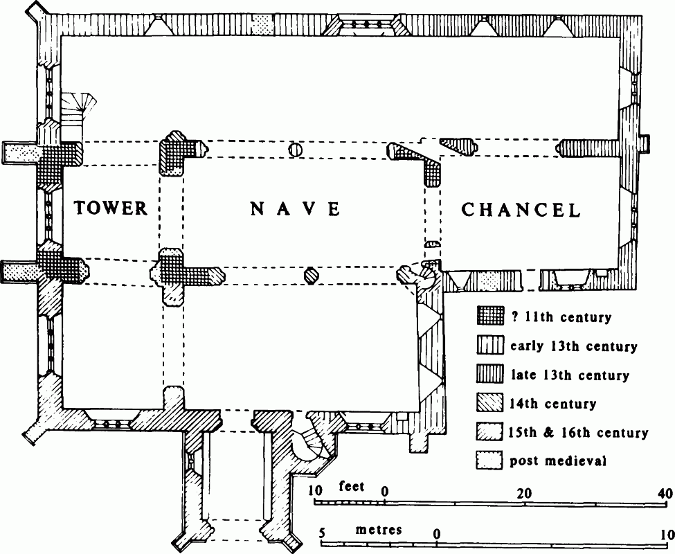
Plan of All Saints' church
Plate was apparently among property stolen from the church before 1550 since the church had none in 1553. In 1988 a chalice given in 1628 and two patens, one hallmarked for 1687, one for 1732, were held. (fn. 309) Three medieval bells, of which the second and third were cast in Gloucester, hung in the church. In 1821 there was a peal of five bells: the first and second were cast in 1633, the other three may have been the medieval bells recast. The entire ring was recast in 1858 by C. & G. Mears. (fn. 310) Registrations of baptisms and burials begin in 1659, those of marriages in 1663. No burial is recorded in the period 1680–94. (fn. 311)
Nonconformity.
That two parishioners were excommunicate and two others failed to attend church in 1674 suggests dissent. (fn. 312) One of the excommunicates failed to attend church in 1683 (fn. 313) but his religious affiliation is unknown.
In 1773, 1800, and 1818 meeting houses for Independents were certified, (fn. 314) and an Independent meeting still flourished in 1833. (fn. 315) A chapel for Particular Baptists open beside the Cirencester-Malmesbury road c. 1840 was attended on Census Sunday in 1851 by 70 in the morning and 100 in the afternoon. (fn. 316) It closed between 1915 and 1920. (fn. 317)
Primitive Methodists, evangelized by William Sanger, certified a house in 1811. (fn. 318) A chapel was opened in Tetbury Lane between 1865 and 1867 and closed between 1939 and 1945. (fn. 319)
Education.
A free school at Crudwell was founded by John, Lord Lucas (d. 1671), possibly between 1630 and 1649. The lords of Crudwell manor appointed the teacher. The school was endowed with 5 a., and the school buildings comprised a stone schoolroom and two adjoining cottages. (fn. 320) It may have been the school of industry in which six children were taught in 1803. (fn. 321) In 1818 the small number of pupils was given as the reason for not opening the school on weekdays: it was claimed, perhaps without justification, that attendance had been better between 1803 and 1818. (fn. 322) By 1833, when c. 18 attended, the school had become a day school, and it was then partly supported by the rector and some parents. (fn. 323) In 1846–7 a woman taught 30 children. (fn. 324) By a Scheme of 1856 the school's management was transferred to a board of trustees, and in 1857 a new school was built beside the old, (fn. 325) which was leased out. In 1859 average attendance was c. 60. (fn. 326) The school was affiliated to the National Society, and in 1871 was attended by 49 children on return day. (fn. 327) The average attendance, 107 in 1905–6, had declined to 73 by 1937–8. (fn. 328) New classrooms were built in the 20th century. In 1985 the income of Crudwell Free School Foundation was £1,679 from the leasing of the land and cottages. (fn. 329) The 108 children on roll in 1989 were taught by six teachers. (fn. 330)
A school supported by J. R. Mullings was opened at Eastcourt in 1858. (fn. 331) It was a National school at which 30 children were taught in 1859 and 1871. (fn. 332) Average attendance declined from 36 in 1906–7 to 21 in 1921–2, and in 1923 the school was closed. (fn. 333)
Charities for the Poor.
Numerous small benefactions were made for the poor, mainly in the 17th century (fn. 334) and most by members of the Earle family. (fn. 335) Giles Earle (will proved 1677) gave £100, and a Thomas Earle £50, to buy bread. In 1775 £582 was invested. In the earlier 19th century the income of £19 was distributed yearly in spring to all the poor. There was no distribution 1832–4 because the aged rector refused to make one. In 1905 £19 was spent on coal, and in 1954 coal for 51 old people was bought with £23. (fn. 336) Coal was last given in 1965, and in 1966 tea for pensioners was bought with £9 of the yearly income of £25. In 1972 a small part of the income was spent on tea, and in 1989 none. The income, £47 in 1989, was allowed to accumulate. (fn. 337)