A History of the County of Stafford: Volume 9, Burton-Upon-Trent. Originally published by Victoria County History, London, 2003.
This free content was digitised by double rekeying. All rights reserved.
'Horninglow: Economic history', in A History of the County of Stafford: Volume 9, Burton-Upon-Trent, (London, 2003) pp. 181-184. British History Online https://www.british-history.ac.uk/vch/staffs/vol9/pp181-184 [accessed 11 April 2024]
In this section
AGRICULTURE
In 1086 there was land at Wetmore for 7 ploughteams, but only 4 teams were actually being worked, of which 2 were on the demesne and 2 were worked by 6 villani. There was 4 a. of meadow, and woodland measured 1 league in length and breadth. The value of the manor had been £4 in 1066 and later £1, but was £2 10s. in 1086. (fn. 11) In the early 12th century there was enough demesne land in Wetmore and Horninglow for three, or two 'very strong', ploughteams, together with some livestock. Almost a third of the tenanted land was then held by villeins who owed fixed labour services and two-thirds by rent-payers. The villeins included a cowherd who presumably grazed the abbey's cattle on the riverside meadows. A reeve named Leofric probably managed a grange there. (fn. 12)
Medieval Grange In the early 13th century a grange (or home farm) at Wetmore was let by Abbot Nicholas of Wallingford to his chamberlain, Ralph of Wetmore. (fn. 13) Its later history is unknown, but the farm was held by lessees in 1534. (fn. 14)
A house evidently dating from the late 15th century or earlier was demolished in the later 18th century, when it was replaced by a smaller house which retained a stone bearing the name of Abbot Thomas Feld (d. 1493). (fn. 15)
Open Fields and Common Land Wetmore field was mentioned in 1395 and 1441, (fn. 16) and in 1498 there was arable in 'Staniholme' field, along the west side of Burton meadow, the island between the river Trent and its western arm. (fn. 17) The main area of arable, however, was at Horninglow. There was an open field in the later 13th century north-west of Horninglow village, probably straddling the Tutbury road and stretching up Beam hill. (fn. 18) Another open field may have lain to the west, where closes named after Hill field survived in the later 18th century along the south side of Kitling Greaves Lane. A third field, probably called Dallow field, evidently lay to the south of the village. (fn. 1)
What was called the 'moor of Burton' in 1298 was almost certainly the great expanse of waste that stretched along the entire east side of Horninglow township, mostly between the village and the line of Ryknild Street. It covered 130 a. in the mid 18th century, when it was called Horninglow Great Moor. (fn. 2)
In 1598 the tenants in Horninglow and Wetmore also had common rights in Burton meadow, after the corn and hay had been cut. (fn. 3)
Inclosure Piecemeal inclosure of the open fields was taking place by the early 18th century, (fn. 4) leaving 95 a. in Beamhill field and 6 a. in Hill field to be inclosed in 1773 under an Act of 1771. (fn. 5) Nearly all of Horninglow Great Moor was also inclosed in 1773 under the 1771 Act, along with 17 a. of open meadow at its north end. (fn. 6) There remained 20 a. belonging to the freeholders of Burton borough at its southern end bounded by the modern Casey Lane. That area was inclosed in 1823 under the Burton inclosure Act of 1812, and the land was allotted to the trustees of the poor of Burton and Burton Extra townships. (fn. 7)
Modern Farms Much of the open land inclosed in 1773 became attached to a small number of farms in the 19th century, even on the former Outwoods common much of which was at first parcelled up among numerous smallholders. (fn. 8)
In 1918 the farmland was devoted to dairying, and the largest farm on the marquess of Anglesey's estate was Chestnuts (129 a.) in Horninglow village, with three others of between 100 a. and 92 a. (fn. 9) Of the 179.4 ha. (443 a.) of farmland returned for Outwoods civil parish in 1988, grassland covered 126 ha. (311 a.). The main crops were wheat and barley (47 ha.; 117 a.). Dairying was important, and there were 197 head of cattle, along with 39 sheep and lambs. Of the six farms returned, only one was over 50 ha.; four were between 10 and 40 ha., and one between 5 and 10 ha. (fn. 10)
RABBIT WARRENS
A rabbit warren called Hunter's warren in 1580 was probably at the southern edge of Outwood, where there was an enclosure called Hunter's copy in the early 18th century. (fn. 11a) In the early 17th century and again in 1636 the manor let a rabbit warren at Outwood, possibly in the same area, together with a lodge. (fn. 12a) A new house for the warrener was built c. 1700. (fn. 13a)
WOODLAND
What in 1324 was called the 'forensic wood', meaning that outside Burton, and in 1372 called the Outwood, covered the western part of Horninglow township. A warden named William in 1324 was styled a woodward in 1333, and he was possibly also responsible for Sinai park, in Branston. (fn. 14a) In the earlier 1540s the warden was paid £1 a year by the manor, a fee still being paid in 1585. (fn. 15a)
According to a verdict of 1407, whose text was seen by a jury in 1598, the inhabitants of Burton township had right of free pasture in Outwood except between Michaelmas (29 September) and Martinmas (11 November), when pannage had to be paid for grazing pigs. (fn. 16a) By the mid 1540s the inhabitants of Horninglow paid 2s. a year to pasture their animals, possibly during pannage time. The fee was known as woodsilver in 1585, when Outwood was also common to the people of Rolleston, Anslow, and Stretton. (fn. 17a) The men of Horninglow were still paying the 2s. fee in 1597, when those of Anslow paid 3s. 4d. (fn. 18a)
When Sir William Paget acquired Burton manor in 1546, the timber in Outwood, along with that in Henhurst on its south-western edge, and also that in Rough hay, in Branston, was thinly-spread and of poor quality. In 1550 Paget ordered its improvement: no timber was to be felled without licence, and then only in designated coppices and only between 2 March and 30 November; and firewood was to be sold only to his tenants, who each year at the Michaelmas great court were to negotiate the quantity of wood needed and the payment for it. (fn. 19) In 1585 the 400-a. Outwood was described as being well-wooded with oak. (fn. 20)
In 1587, after Thomas, Lord Paget, had been attainted and lost his estates, the queen let what was then called Horninglow Outwoods for 31 years to Sir Fulke Greville. In 1589 Greville also acquired a lease of woodland in Cannock Chase, which he despoiled in order to fuel iron furnaces and forges included in that lease. (fn. 1a) Greville also despoiled Outwood: it was estimated in 1595 that nearly 4,800 trees had been felled, and the area of woodland was given as only 80 a. in 1598. (fn. 2a) When William Paget regained the manor in 1597, he too felled timber for building work at his house in Burton, and by 1619 the timber was so meagre that no value could be set. (fn. 3a)
In the late 17th century and early 18th century Lord Paget tried to improve the woodland, by inclosing Henhurst and by trying to restrict the common pasture rights of people in Rolleston and Anslow. (fn. 4a) Outwood common, which covered 574 a. in the late 1750s, was inclosed in 1773 under an Act of 1771. Of the 555 a. inclosed, Lord Paget was awarded 30 a. as lord of the manor and 42 a. in lieu of tithes; a further 57 a. was awarded to him in respect of his freehold land. Twenty-three Horninglow leaseholders each received 2 or 3 a., and the rest of the land was allotted in small parcels to over 100 others, many of them Rolleston people. (fn. 5a)
The Henhurst part of Outwood was recorded as a separate area of woodland in 1327. (fn. 6a) It covered 50 a. in 1585, when it was described as well-wooded with oaks of between 80 and 100 years old. (fn. 7a) It was evidently included in the 1587 lease of Horninglow Outwoods to Sir Fulke Greville, and was despoiled: the area of woodland was given as only 12 a. in 1598. (fn. 8a) About 1670 Lord Paget inclosed Henhurst in order to protect the timber. After nine years he allowed his tenants in Horninglow and Branston, but not people from Rolleston, to resume their common rights; with their consent, however, Henhurst was inclosed again a few years later. A hedge was constructed in 1699, and the wood remained in severalty. (fn. 9a) It covered 68 a. in the late 1750s. (fn. 10a) Some felling took place in 1772, 1823, and 1837, but there was still 77 a. of wood in Henhurst in 1918. (fn. 11b) Only 1.2 ha. (3 a.) of woodland, however, was returned for Outwoods civil parish in 1988. (fn. 12b)
INDUSTRY
Alabaster from a gypsum deposit in Horninglow was supplied in 1546 for a chimney-piece to be installed in Sir William Paget's house, probably at Burton. (fn. 13b) It was still being dug north of Horninglow village in the late 18th century. (fn. 14b)
A steam mill evidently built in 1805 beside the Trent and Mersey canal was later run, probably as a saw mill, by Michael Bass and William Carter, who by 1818 had a timber yard there. (fn. 15b) In 1857 the yard, which lay on the north side of the main road, was managed by a partnership named Bass and Smith, probably the William Bass and Henry Smith recorded as partners in 1869. The yard was closed in the mid 1890s. (fn. 16b)
A brewery in Horninglow run by a partnership headed by E. Coats was sold in 1806, following a bankruptcy. (fn. 17b) It may have been the brewery which by 1839 was run by John Marston, probably at the east end of Dover Road, its site in 1851. (fn. 18b) Marston died in 1846, and the brewery was continued by his sons, who employed 70 men in 1861. (fn. 19a) By 1879 a new brewery had been erected at the corner of Horninglow Road North and Rolleston Road. (fn. 20a) In 1898 the firm of John Marston and Sons Ltd. merged with the Burton brewing firm of John Thompson and Sons Ltd., and the combined firm moved to Albion brewery in Shobnall Road, in Burton. (fn. 21) By 1903 the Horninglow Road building was used by William Wardle & Co. to manufacture cattle food from spent hops acquired from local breweries. Still there in 1906, the manufactory had been moved to Cross Street, in Burton, by 1908, possibly because of complaints from residents. (fn. 22) The Horninglow Road building was still in commercial use in 1999.
An iron and steel works was opened in the mid 1870s by B. F. Peacock & Co. on the north side of Dallow Lane (later Belvedere Road) near the canal. Production seems to have stopped by 1877, when the works was offered for sale. (fn. 23) In the early 20th century the site was occupied by the brewing firm of Truman, Hanbury and Buxton of Derby Street, in Burton. (fn. 1b)
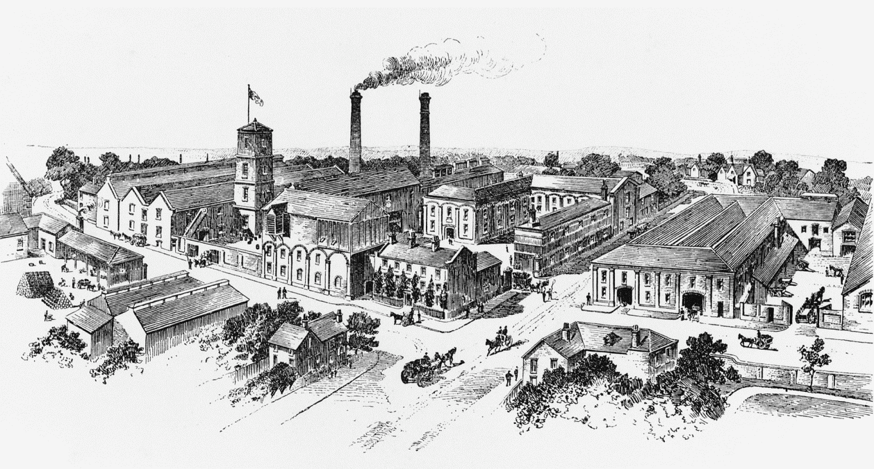
John Marston and Sons Ltd. brewery from the east in the late 1880s
Two rubber factories were opened in Horninglow in 1916: (fn. 2b) one, a branch of Messrs. Werneth, stood on the east side of Derby Road, (fn. 3b) and the other, a branch of the India Rubber, Gutta Percha and Telegraph Works Co. of Silvertown, in West Ham (Essex), on the north side of Horninglow Road North. (fn. 4b) Production at the Horninglow Road site ceased in 1931, but it was restarted in 1933 by the British Goodrich Rubber Co., by then the owners of the Derby Road factory. The Horninglow Road works concentrated on the manufacture of car and cycle tyres and the Derby Road works on footwear. In 1957 the parent company (by then the British Tyre and Rubber Co.) ceased making tyres and concentrated on other rubber-to-metal products under the name of BTR Industries Ltd. The company managing the Horninglow Road and Derby Road works became BTR Silvertown Ltd. in 1965, after the closure of the Silvertown factory, and production at Horninglow Road was extended to include the application of chemically-resistant plastics to metal fittings. The manufacture of moulded rubber products at the Horninglow Road factory was further increased after the closure of the Derby Road works in 1972 and the closure in the 1980s of factories elsewhere in the country by the parent company. When BTR plc decided in 1996 to concentrate on its engineering interests, the rubber and plastics division was bought by a consortium of managers, and the Horninglow works was renamed Silvertown UK Ltd.
By 1916 Burton Constructional Engineering Co. Ltd. had built a factory for the manufacture of steel building frames on the east side of the railway line off Wetmore Road. (fn. 5b)
Plasplugs Ltd. opened a factory in the angle of Derby Road and Wetmore Road in 1986. Established originally in 1970 with a small factory in Shobnall Road in Burton, the company makes a wide range of tools and fixings mainly for amateur home decorators. (fn. 6b)