A History of the County of Essex: Volume 10, Lexden Hundred (Part) Including Dedham, Earls Colne and Wivenhoe. Originally published by Victoria County History, London, 2001.
This free content was digitised by double rekeying. All rights reserved.
'Chappel: Introduction', in A History of the County of Essex: Volume 10, Lexden Hundred (Part) Including Dedham, Earls Colne and Wivenhoe, (London, 2001) pp. 76-80. British History Online https://www.british-history.ac.uk/vch/essex/vol10/pp76-80 [accessed 24 April 2024]
CHAPPEL
THE small parish of Chappel, earlier Pontisbright, lies c. 7 miles west of Colchester, in the Colne valley. (fn. 1) Although the part of the parish north of the Colne was until 1889 intermixed with Wakes Colne and Mount Bures (fn. 2) and remains intermixed with Wakes Colne, in the Middle Ages Chappel was part of Great Tey parish. It was occasionally called a parish from 1483, but it was not separately taxed until the mid 16th century, and its status was still disputed in 1628. (fn. 3) The ties with Wakes Colne and Great Tey were strengthened by the manorial structure, the western half of the parish being in Great Tey manor, most of the eastern half being in Crepping manor which was centred on Crepping Hall in Wakes Colne. (fn. 4)
The parish, as surveyed in the 19th century and probably as in 1628, comprised 1,176 a., including three detached areas (48 a., 23 a., and 8 a.) in Wakes Colne and Mount Bures; within it were three detached areas of Wakes Colne (1/2; a., 2 1/2; a., and 3 a.) and two of Mount Bures (9 a. and 17 a.). In 1888 and 1889, under the Divided Parishes Act, 8 a. was transferred from Chappel to Mount Bures, and a total of 71 a. from Chappel to Wakes Colne, while totals of 6 a. and 26 a. were transferred from Wakes Colne and Mount Bures to Chappel. (fn. 5) The 20th- century parish contained 1,148 a. or 466 ha.
The north-western boundary followed the Colne, although in 1810 Wakes Colne claimed part of a meadow on the south bank; on the west and south the boundary with Great Tey followed field boundaries and lanes, except for a short distance where it crossed 19th-century fields. On the south-east the boundary with Aldham ignored some field boundaries and ran through a farmhouse; on the east it ran straight across the 19th-century fields to the Colne. North of the Colne, the boundary with Wakes Colne and Mount Bures mainly followed field boundaries, but in places ran across the 19th- century fields. The bounds were perambulated until 1828 or later. (fn. 6)
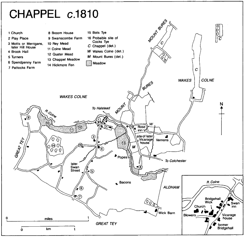
Chappel c. 1810
The land slopes from over 61 m. near the southern boundary, and from 46 m. at Spring Gardens Road in the north, down to c. 23 m. at the Colne. The higher land, including about half the area south of the Colne, is boulder clay, but along the Colne are bands of river terrace deposits, London clay, and Kesgrave sand and gravel; a wide stretch of alluvium along the southern bank provides ample meadow. (fn. 7)
The parish took its medieval name from the bridge, recorded from the 1140s, by which the Great Tey to Mount Bures road crosses the Colne. In the 13th century it was Britric's bridge, presumably from its pre-Conquest holder, and the name was Latinised as Pontisbright. (fn. 8) Bridgehallwick, probably from a meadow ('halh') rather than a hall, seems to have been an alternative name for all or part of the parish in the 14th century. That name, first used for a pasture in 1328, suggests that the settlement may have started as an outlying dairy farm of Crepping manor in which Bridgehall field lay. (fn. 9) The modern name, used from the 16th century, is from the medieval chapel near the bridge. (fn. 10)
The Colchester-Halstead road crosses the northern part of the parish, and the road to Great Tey runs south from it, over the bridge, to the southern parish boundary. Lanes or tracks lead to the outlying farms, Fen Hill, which earlier led to Swanscombe farm, curving to skirt a once wooded area of which only Hickmore Fen survived in 1999.
In 1272 the lord of Crepping manor and the rector of Great Tey were ordered to repair Chappel bridge. In 1441 and 1509 the lord of Crepping alone was liable for its repair, (fn. 11) and between 1616 and 1622 he was several times ordered to repair the dangerous structure. (fn. 12) By 1810 Bridge meadow (1/4; a.), north of the bridge, belonged to Chappel parish to maintain the bridge, (fn. 13) but in 1855 responsibility for the bridge devolved onto the owner of the major portion of the Crepping Hall estate. (fn. 14) The sur- viving steel bridge was built by the Rural District council in 1907. (fn. 15)
Small bridge in Rey meadow in the north- west corner of the parish, recorded in 1444 and the responsibility of the bailiff of Great Tey manor in 1512, was presumably a footbridge over the Colne. (fn. 16) Rombridge lane, the modern Oak Road, so called c. 1480, in 1593, and c. 1613, (fn. 17) presumably started at a bridge or causeway over the brook which crosses the Tey road at the modern Brook Hall. (fn. 18)
The Colchester, Stour Valley, Sudbury, and Halstead Railway company built its line through Chappel between 1847 and 1849. The railway crosses the Colne valley by a brick viaduct, 1,136 ft. long with 32 arches, designed by the engineer Peter Bruff; (fn. 19) it has since dominated the parish. The station, although called Chappel, is in Wakes Colne. (fn. 20) The line remained open in 1999. Chappel was served by a carrier and a horse- drawn omnibus from Wakes Colne to Colchester in 1848. Arthur Hutley of Coggeshall started a motor bus service through Chappel to Col- chester in 1914, and from the 1930s to the 1950s S. Blackwell of Earls Colne ran an express coach from Chappel to London. (fn. 21)
Apart from an unconfirmed report of a mosaic pavement on Viaduct farm, possibly on the east side of the Tey road near the church, (fn. 22) there is no evidence for prehistoric or Roman settlement in the parish. There was probably a small settle- ment at the bridge by 1285, as well as scattered farmhouses, (fn. 23) but since Chappel was not separately assessed for taxation until the mid 16th century, no estimates can be made of its early population. Forty-six households, 22 of them exempt, were assessed for hearth tax in 1671, and 128 adults were reported in 1676. (fn. 24) There were c. 40 families in the parish in 1723. (fn. 25) The population increased to 269 in 1801 and 452 in 1851, fell to 353 (in a slightly smaller parish) in 1891, then rose to 422 in 1951. It declined again in the 1950s and 1960s, to 342 in 1971, rose to 492 in 1981, and fell again to 463 in 1991. (fn. 26) By c. 1810 there was a second small hamlet, at the junction of the Tey road and Bacons Lane; it was called Swan Street by 1851. (fn. 27)
The earliest surviving houses lie close to the bridge. (fn. 28) Raynhams has a north wing of c. 1350, though it is otherwise of c. 1600, while the nearby Swan inn has a late 14th-century hall attached to a slightly earlier cross wing. The north cross wings at both Raynhams and The Swan were jettied but have been curtailed, poss- ibly because of an increase in traffic using the bridge. Both buildings have smoke-blackened kitchens, that at Raynhams being detached to the north and dating from the 15th century; the kitchen at the Swan was attached to the cross wing in the late 16th century when the hall was floored. Bridgewick Cottages, called part of Bridgehall in 1735, (fn. 29) has an earlier 16th-century hall and cross wing. Bridgewick Hall, formerly Bridgehall Wick and earlier Havens from its early 15th-century tenant, (fn. 30) lies immediately east of the church. The surviving house may have originated as a hall with a two-storeyed end in line to the west. (fn. 31) It was enlarged in the later 16th or the early 17th century, when the hall was floored and the west end was extended northwards. West of the church, Viaduct Farm, recorded as Blowers in 1593, (fn. 32) also contains 16th-century fabric.
Further south, on the main road, is Hill House, earlier Motts from John Mott (d. 1401), (fn. 33) which retains a 15th- or early 16th- century cross wing. At the nearby Brook Hall, only the 15th-century cross wings survive, the three-bayed hall having been rebuilt in brick in the 1890s. Turners, which may be named for its mid 16th-century owner, John Turner, later of Crepping Hall, (fn. 34) is the oldest house at Swan Street, probably mid 16th-century with a hall and storeyed end in line under a wind-braced side-purlin roof. The core of Pattocks, still further south, is roughly contemporary with Turners. South-east of the bridge is Popes, the centre of a freehold estate held in 1284 by Richard Pope. (fn. 35) The house was built by the Creffields in the later 15th century; it has a three-bayed hall and two cross wings, the wings originally jettied to the east at first-floor and tie- beam level.
North of the Colne, (fn. 36) Vernons, on the site of a freehold held by John Vernon (d. 1334), (fn. 37) incorporates in its north wing, two two-bayed, early 17th-century blocks set one behind the other. The southern, which had an external west stack and a large south window, may have been a parlour cross wing to a main range on its east side; the northern block may have been a second parlour. Broom House was built c. 1550 (fn. 38) with a main range and two cross wings.
Surviving 17th-and 18th-century houses are simple lobby-entrance dwellings. They include Viaduct Cottages in Chappel Street, which was extended in the 18th century, Martyns Croft, opposite Hill House, which was extended after 1810, and Spendpenny Farm. (fn. 39) Most of Hill House was rebuilt as a three-bayed two-storeyed range in the earlier 17th century, probably by the Creffields, (fn. 40) and late in the 17th century Bridgewick Hall was remodelled and enlarged as a fashionable gentleman's residence, presum- ably by Solomon Grimston, who owned it from 1680 to 1747. (fn. 41) The house was extended eastwards and raised to give taller first-floor rooms and attics, and a staircase tower was built on the north side; the interior was refitted. About that time a generous staircase projection was added at Popes, and c. 50 years later at Bridgewick Cottages, a similar staircase, and probably the south wing with fashionable fittings, was built. Vernons was enlarged in the 18th century and again in the 20th. A 17th-century barn to the north of the house was greatly extended in the 19th century when part of it was used as stables, and was reconstructed as a house in the later 20th century.
Modernization continued into the early 19th century. Bridgewick Hall was refronted, probably in the 1820s, to create a symmetrical facade; the surviving plaster panels of neoclassical subjects were presumably added then. (fn. 42) Hill House was remodelled c. 1830 with ornamental plasterwork, a new staircase, and sash windows. At Pattocks a new brick front range, with delicate neoclassical doorcase, was built in the 1810s. (fn. 43) At Popes a new entrance block was built between 1810 and 1876, and Viaduct Farm was given a remarkable external appearance with a casing of gault brick and ornamental chimney stack, perhaps by W. M. Farrow (d. 1847). (fn. 44) Broom House was enlarged and refronted in brick in the later 19th century. A single-storeyed outbuilding, probably a 17th-century stable, to the east, was enlarged by the addition of an upper floor for a granary. At Rose Green (earlier Bots Tye), on the Colchester road, where there had been houses from the 14th century or earlier, (fn. 45) timber- framed labourers' cottages were built between 1810 and 1839, encroaching on the south- western side of the green. On the north two detached villas, Rose Cottage (Merry Hill in 1999) and the Elms, were built c. 1839, and the nearby Alma Cottage (Abbots Manor in 1999) before 1876. (fn. 46) A few brick cottages, including Myrtle Cottages dated 1883, were built late in the century at Swan Street.
In the early 20th century Colchester Road was further developed, the houses including Peace Villas dated 1902. In the 1920s and 1930s a pair of semi-detached villas and a larger house, all of brick, were built on the south side of Bacons Lane. Later 20th-century development enlarged the hamlet at Swan Street. Swanscombe Farm, by the Colne in the north-west corner of the parish, recorded from 1421 and probably named for John Swanscombe (fl. 1279), (fn. 47) was rebuilt in the late 20th century. Council houses were built in Spring Gardens in 1954, and 3 old people's bungalows at the southern end of the Street in 1966. In 1972 Swan Gardens, an estate of 34 houses, was built behind the bungalows. (fn. 48) Low- cost houses were built north of Rose Green in 1998.
There was a post office by 1866. (fn. 49) Electricity was supplied by Colchester borough from 1933, (fn. 50) mains water by Lexden and Winstree Rural District Council c. 1954, and main drainage by the same council in 1964. (fn. 51)
Two inns were licensed in 1580, one perhaps at the later Bridgewick Hall, which was almost certainly an alehouse between 1606 and 1619. (fn. 52) By 1754 the two inns were the Swan, by the bridge, and the Rose, which gave its name to Rose Green. (fn. 53) The Swan, an old-established village inn in 1905, (fn. 54) was still open in 1999. A friendly society was registered there in 1844. (fn. 55)
The Rose, the Rose and Crown in 1753 and c. 1810, closed c. 1960, (fn. 56) becoming the Viaduct café until c. 1989.
There was a playing place near Chappel bridge in 1596. (fn. 57) In 1879 the attempt by the landowner, Golden Goodey, to inclose part of the land provoked violent protests, and in 1880 Playing Place was confirmed as a recreation ground. (fn. 58) It remained an open space and children's playground in 1999. The nearby pond was known in 1997 for its great crested newts. (fn. 59)
The novelist Margery Allingham visited Chappel as a child when her aunt, Grace Chef- fins, lived at Popes Hall, and lived there herself, at Viaduct Farm, from 1931 to 1935. (fn. 60)