A History of the County of Cambridge and the Isle of Ely: Volume 9, Chesterton, Northstowe, and Papworth Hundreds. Originally published by Victoria County History, London, 1989.
This free content was digitised by double rekeying. All rights reserved.
'Cottenham: Introduction', in A History of the County of Cambridge and the Isle of Ely: Volume 9, Chesterton, Northstowe, and Papworth Hundreds, (London, 1989) pp. 48-54. British History Online https://www.british-history.ac.uk/vch/cambs/vol9/pp48-54 [accessed 19 April 2024]
Cottenham
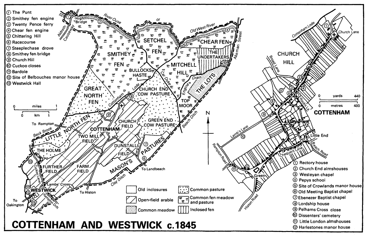
The parish of Cottenham, (fn. 1) covering 2,924 ha. (7,224 a.) until 1985 and 2,927 ha. (7,231 a.) afterwards, (fn. 2) comprises a wedge of land with a wide base on the river Ouse or Old West River, tapering to a flattened point along Rampton Drift 9 km. (5½; miles) to the south. The village lies in the southern part of the parish on a shallow ridge of Lower Greensand 7.5-9 m. (25-30 ft.) above sea level. Extending northeastwards from Rampton Drift for 4 km. (2½ miles), the ridge rises above clay and gravel deposits along the parish boundaries to the north-west and south-east. The northern part of the parish lies below 4.5 m. (15 ft.). (fn. 3) Peat beds in the north-east corner of the parish have almost been worked out. (fn. 4) The soil of the ridge is fertile red loam; part of the fens was described in the 1790s as having a strong black loamy mould, but nearer the river the soils are lighter. (fn. 5) No ancient woodland was recorded in 1086 (fn. 6) and in the late 16th and the 17th century willows, osiers, and hedgerow trees were conserved. (fn. 7) The ridge and the lower-lying land correspond respectively to the former arable fields and to the extensive meadows, pastures, and fens on which the inhabitants were largely dependent before the mid 19th century. Some common pastures were inclosed in the 16th century and the remaining commons and the open fields in 1847. (fn. 8)
The parish boundaries in the fens were mostly fixed only in the 13th century. Intercommonable pastures between Cottenham and Landbeach were divided in 1235 when the straight Beach Ditch was dug, (fn. 9) though the boundary with Waterbeach is evidently older, following the Roman Akeman Street. (fn. 10) The boundary with Histon was defined in 1273 when Great and Little Moor were apportioned between the parishes, (fn. 11) and that with Rampton and Willingham follows a watercourse which is partly artificial. Rampton Drift has entirely formed the boundary with Westwick since 1985, when c. 3 ha. (7 a.) belonging to Westwick east of the lane were transferred to Cottenham. (fn. 12)
The drainage of the parish has been much altered. (fn. 13) The natural watercourses were Beck brook, which still forms part of the Rampton boundary and probably once continued northwards in a meandering course, and a brook on the south-east side of the parish. The medieval Clay Ditch between Histon and Cottenham was part of the southern brook, whose course to the north is partly represented by the line of Steeplechase drove and part of Engine drain.
The Roman Car Dyke, formerly called the Old Tillage and probably constructed in the early 2nd century A.D. to link the Cam with the Ouse at Earith, cut across the natural drainage of Cottenham. The present river Ouse west of its junction with the dyke was part of the Roman canal. In the 3rd century freshwater flooding breached Car Dyke at that point to create the eastward meanders of the Ouse from the junction to the Cam. Car Dyke probably fell into disuse for transport in the 4th century. (fn. 14) Cottenham lode between the village and the dyke may also have been dug by the Romans. (fn. 15)
In 1279 the marsh of Cottenham was bounded by Clay bridge, which perhaps lay near the modern Smithey fen bridge just north of the church, the great bridge on Aldreth causeway, Chear fen, and the Old Tillage, presumably at its junction with Beach Ditch, (fn. 16) thus taking in all the fens north of the village but not the later pastures and meadows east and west of the ridge. Those areas may have become wetter in the early 14th century, when arable was flooded. (fn. 17) Conversely, improvement of grass land in the western part of the marsh is suggested by the replacement in the mid 14th century of the name Frith fen, which referred to the roughest sort of fen, by the name Smithey fen, (fn. 18) probably alluding to cleared land. (fn. 19) The other main divisions of the fens then and later were Setchel fen in the centre and Chear fen on the east. (fn. 20) By the early 16th century the fens were protected by banks, the most important evidently being Grekenhill fen bank. (fn. 21) By 1600 there were others in Top Moor and between Twenty Pence and Chittering along the river. (fn. 22) They did not prevent winter flooding, (fn. 23) but kept the fens open for grazing longer than would otherwise have been possible. In 1604 the banks and drains were thought better than those of neighbouring parishes, though Chear fen was under water longer each year than the rest, (fn. 24) probably because the ground surface had been lowered by the removal of peat. (fn. 25)
Schemes put forward in the 1610s to improve the general drainage of the area by increasing the flow of the Ouse (fn. 26) were opposed by Cottenham because the parish's own drains were considered effective. (fn. 27) In 1618 there had been recent improvements to banks and ditches in the parish, though they were thought to have reduced the lushness of the fen pastures, which depended on regular inundations. The farmers were therefore damming the river with barn doors to irrigate their land. (fn. 28)
Opposition to the drainage of the South Level in the 1630s and 1650s included a riot in Cottenham fen in 1637. (fn. 29) The main work completed there was the barrier bank all along the south side of the Ouse. An area of 239 a. in the northeast corner of the parish was allotted to the Bedford Level Corporation in 1663, and was afterwards known as the Undertakers. (fn. 30) The barrier bank did not always keep out floods. About 1737 the section in Chear fen needed repair, (fn. 31) and c. 1806 an area of 1,000 a. was said to be constantly under water in winter. (fn. 32)
The fens were finally drained under an Act of 1842, (fn. 33) placing 4,840 a. in Cottenham under the authority of a drainage commission which erected steam pumping engines in Smithey fen and Chear fen and dug the necessary ditches. (fn. 34) An oil-burning engine was added at Smithey fen in 1915 and diesel engines at both in 1942, when the steam engines were removed. From 1986 the west part of the district was drained by electric pumps. (fn. 35)
River transport was probably important to the village throughout the Middle Ages. (fn. 36) Cottenham lode led to the Ouse by two branches, joining the river near Twenty Pence and east of Chear fen. In the early 17th century the eastern branch was called Cottenham lode while the western, to which that name was later transferred, was Robbin's lode. (fn. 37) In 1430 the lode had insufficient water for regular use by laden boats in summer. (fn. 38) A small basin behind the rectory was filled in only in the 20th century. (fn. 39) In 1847 the towpath along the lode from a landing place by Smithey fen bridge to the Ouse was made public, though a stretch south from the landing place was closed. (fn. 40)
Cottenham and Westwick c. 1845
Aldreth causeway, the medieval road from Cambridge to Ely, crosses the north-west tip of the parish, where Aldreth High Bridge took it over the Ouse. Rampton Drift was part of the same route, which declined greatly in importance in the 18th century, the bridge becoming unusable in the late 19th. (fn. 41) The main road out of Cottenham has always been that leading south to Histon and Cambridge. From the green at the south end of the village a side road leads to Rampton and Willingham, with a branch to Westwick and Oakington. Beach Road leads south-east from the village to Landbeach. The main ways into the fens were along the road to Twenty Pence, over Smithey fen bridge into the western fens, and along Broad Lane to North fen on the Rampton boundary. In the 16th century money was frequently left for the repair of the main street, the highway to Histon, and Smithey fen causeway. (fn. 42) From 1543 the Church and Causeway estate regularly repaired 'the stone causeway' (evidently High Street) and Smithey fen causeway. (fn. 43) High Street was well maintained in the late 18th and early 19th century, being paved probably from c. 1809. (fn. 44)
The roads to Histon, Landbeach, Rampton, and Westwick were straightened at inclosure in 1847, (fn. 45) when c. 10 roads and footpaths across the fens and many around the village and over the fields were closed. (fn. 46) Straight drove roads across the fens were laid out instead, including Twenty Pence Road linking the north end of High Street and Twenty Pence ferry, and Long Drove leading through the eastern part of the fens. (fn. 47) Local demands in 1842 for Twenty Pence Road to be made a public road (fn. 48) and c. 1910 for a bridge to replace the ferry (fn. 49) were unheeded, though by 1901 there was a private toll house on the road and a floating bridge over the Ouse. (fn. 50) In 1929 the road was adopted by the county council, which metalled it and built a bridge at Twenty Pence. (fn. 51) Traffic through Cottenham between south Cambridgeshire and the Isle of Ely thereafter increased. The nearest railway station to Cottenham was at Oakington. (fn. 52) A projected light railway from the village for market garden produce and bricks was not built. (fn. 53)
Cottenham has been among the largest villages in Cambridgeshire since the 11th century. It had 60 tenants in 1086, (fn. 54) and in 1279 more than twice that number of landholders, 134 apart from the lords. (fn. 55) A similar number, 132 persons, paid taxes in Cottenham and Westwick in 1327. (fn. 56) The holders of at least 33 of the 58 holdings on Crowlands manor died during the Black Death, (fn. 57) but the population recovered and stood at 121 families in 1563. (fn. 58) Later growth brought it to 560 adults in 1676 (fn. 59) and a little under 1,100 inhabitants in 245 families in 1801. The population grew quickly until the mid 19th century, more than doubling to c. 2,300 in 1851, then fluctuated at almost the same level until the 1960s, never rising much above 2,500 or falling below 2,300 at a time when most Cambridgeshire parishes underwent great changes. The county council's policy from the late 1960s of encouraging new building increased the population very rapidly from 2,400 in 1961 to 4, 125 in 1981, most of the growth taking place in the 1960s. (fn. 60)
Between the 2nd and 4th centuries A.D. the fen edge north of Cottenham contained numerous farms and perhaps a minor commercial and religious centre. (fn. 61) The settlements were presumably abandoned in the period of falling population and a wetter climate from the 4th century onwards, (fn. 62) and from the Middle Ages to the 19th century settlement was almost exclusively on the dry ridge in the south part of the parish.
The main village street stretches from the church for 1.75 km. (over 1 mile) SSW. to a large triangular green which had a pond until 1928. (fn. 63) The full length of the street, with two sharp bends, was occupied by the late 13th century, earning the name Wrongstreet in reference to its crookedness. (fn. 64) The name was still in use in the late 16th century. (fn. 65)
In the 11th century the settlements at the church and at Crowlands manor house near the northern bend may have been separate, one for each of the two 11th-century manors, corresponding to the two Cottenhams which were perhaps distinguished in 1086. (fn. 66) In the 17th century copyhold houses belonging to the Crowland and Ely fees were scattered throughout the village, (fn. 67) resulting from a reorganization when the Ely fee was divided or from the laying out of new tofts. High Street between the church and Crowlands manor house included at least four distinct blocks of tofts, (fn. 68) possibly the result of piecemeal development between the 11th and the 13th century. The stretch south of the southern bend has a regular plan, probably between two triangular greens, but by the late 13th century the local surname 'at green' (fn. 69) implies that only one remained, the surviving southern green. Other regular tofts, presumably medieval in origin, line Church Lane, east of the church, and a lane between the former northern green and Little End, perhaps a third focus of early settlement. Once called Chequers Lane, from the alehouse at the High Street end, (fn. 70) it was renamed Denmark Road after a visit to Cottenham races in 1870 by the Princess of Wales, Alexandra of Denmark. (fn. 71)
In the early 14th century there were ruinous houses in Cottenham, (fn. 72) presumably due to depopulation, but although some empty tofts were recorded in the 16th century, (fn. 73) the village probably suffered no overall shrinkage. Three cottages built on the commons were ordered to be demolished in 1596, when no more were allowed there apart from a shed for the fen keeper. (fn. 74) Another bylaw prevented householders from encroaching on High Street. (fn. 75) In the 1660s and 1670s the village contained c. 220 houses, over two fifths of which had only one hearth, and almost another two fifths two hearths. Of the larger houses there were c. 10 with five or more hearths. (fn. 76) The compactness of the houses led one 17th-century observer to describe Cottenham as the equal of many eminent towns, but it facilitated the spread of a fire in 1676, which destroyed half the village. (fn. 77) Two surviving houses, both timber-framed, may date from before the fire, the Old House (no. 11 High Street), which has a large hall range and two substantial cross wings, of two storeys with attics throughout, and no. 279 High Street, a two-storeyed lobby-entry house with one cross wing. (fn. 78) At least 20 timberframed houses and cottages survive from the late 17th or early 18th century, mainly along the entire length of High Street. The typical plan is of three bays with a lobby entry, a few having a cross wing also. Two storeys and one storey with attics are equally common.
In the 17th and 18th centuries the village expanded into a network of lanes east of High Street. By 1700 there were houses in Corbett Street, which runs roughly parallel to Denmark Road from the central portion of High Street; two of them survived in 1987. By the early 19th century numerous dwellings, mainly cottages, had been built in both those streets and also on the north side of a street linking them (later Telegraph Street) and at the west end of two lanes joining High Street with Corbett Street, later called Rooks Street and Margett Street. (fn. 79)
The number of houses did not again reach the level attained just before the 1676 fire until the 1820s, though by 1851 there were almost 500 dwellings in Cottenham, to which a further 100 were added by the end of the century. (fn. 80) The farmhouses were concentrated in High Street; in 1833 it was said that almost every house there had a farmstead behind it. (fn. 81) Many were rebuilt in the early 19th century, usually as substantial three-bayed double-pile villas in local gault brick and slate. About 60 of them survive in High Street, (fn. 82) with a few more in the back lanes; most are of two storeys. The earliest may date from c. 1815. Some 17th-century houses were refronted and reroofed in the early 19th century to give a similar appearance. Most new building, however, was of cottages, mainly in the back lanes and in the yards of farmhouses fronting High Street. Rows of cottages in farmyards were recorded in the mid 19th century and later (fn. 83) but none from before c. 1850 survived in the 1980s.
Fires in 1827, 1847, and 1852 each consumed at least 10 houses, and one in 1850 destroyed 35 houses, 26 farms, and 7 shops. (fn. 84) Cottage building continued in the 1840s and later. In 1841 there were 407 dwellings in the village, of which 276 were in High Street, Church Lane, and the yards, 120 in the lanes east of High Street, and only 11 in lanes west of the street. (fn. 85) The total increased by 40 per cent in the 40 years after 1841, the fastest rate being in the 1840s. (fn. 86) Building land was commanding a high price in 1852. (fn. 87) High Street was already almost entirely built up, and of over 150 new houses c. 100 went up in the lanes east and west, mainly in Broad Lane and Rooks Lane. (fn. 88) The only completely new street was Ivatt Street west of High Street towards its north end, where 12 cottages were built in 1865. (fn. 89) By 1881 building had extended beyond the old village and there were 31 houses in Histon Road, built gradually since the 1840s, and 26 in the fens, most of which were put up by 1851. Those in the fens were mainly ourroomed labourers' cottages, a few of which survived in 1987, but included six licensed houses, cottages at both pumping engines, and at least two farms.
The number of houses increased by only c. 25 between 1881 and 1901 (fn. 90) and overcrowding was reported in 1909. (fn. 91) From c. 600 houses in 1901, the village grew to almost 900 in 1961 and nearly 1,500 in 1981. (fn. 92) Most of those built before 1939 were along the roads to Histon and Rampton. Gaps continued to be filled after the Second World War, and by 1986 there were c. 100 houses in Histon Road and c. 140 in Rampton Road, besides c. 20 in Beach Road. Council houses were built on the outskirts of the village and mainly in large estates: the Victory Way estate north-east of Lamb's Lane had c. 90 houses, Oakington Road c. 65, and Coolidge Gardens off Beach Road c. 140. An old people's home at Little End was opened in 1965. (fn. 93) Largescale private building began in 1964 and continued into the 1980s. (fn. 94) It was concentrated in the rectangle of land, formerly orchards and market gardens, bounded by High Street, Lamb's Lane, and Rampton Road, all of which were already built up. Almost 250 houses were built there, mainly between the mid 1960s and late 1970s. (fn. 95) Other private estates contained c. 80 houses, besides individual houses and small groups in gaps along High Street. The demolition of older cottages and increased use for shops and offices, however, meant that High Street in 1986 had no more occupied dwellings than a century earlier. Infilling had a greater effect on the lanes east and west of High Street, which by 1986 had few gaps. A site for permanent caravans off Broad Lane had c. 70 dwellings in 1986.
In 1686 Cottenham's inns provided beds for 6 guests and stabling for 8 horses. (fn. 96) The village men in the mid 18th century were reputed great drinkers and were called the Cottenham gulpers, though the name had evidently passed out of use a century later, perhaps due to the sobering influence of nonconformity. (fn. 97) Five licensed houses were recorded from 1765, (fn. 98) of which the White Horse and the Chequers (fn. 99) survived in 1987. Three more were licensed by c. 1825. (fn. 100) By 1847 there were 12 public houses, and more were opened in the mid 19th century to reach a peak of c. 20 by 1875, (fn. 101) besides numerous beerhouses. (fn. 102) The most prominent in the village were the White Horse, which styled itself a hotel c. 1908 and later, and the Hop Bind, open under that name from c. 1852, both of which housed auctions and public meetings. (fn. 103) The number of licensed houses fell after c. 1900. (fn. 104) In the fens, only four remained in 1910, (fn. 105) and in 1987 only the former Jolly Waterman at Smithey fen bridge, renamed the Hunter's Fen and enhanced by a restaurant. The number in the village declined to 8 or 9 between the 1930s and c. 1960 (fn. 106) and only 5 in 1987.
Before the Second World War the residents of Church End and Green End were seen as forming distinct communities, and before 1914 Church End held its own annual Feast on Shrove Tuesday. (fn. 107) Later there was only the main Cottenham Feast, traditionally held on the Sunday after old Michaelmas. (fn. 108) From the mid 19th century the village had an active social life of lectures, concerts, sports, and societies. (fn. 109) Cottenham's pretensions to urbanity are shown by the foundation in 1853 of a reading room, the Philo-Union, modelled on a society of the same name in Cambridge. Despite early difficulties it continued to function much as planned (fn. 110) until replaced in 1904 by the Victoria Institute, a private club at the northern bend of High Street. Financially unsuccessful, it became a Conservative club in 1911 (fn. 111) and remained so in 1987. Choral society concerts were recorded from 1858. (fn. 112) After 1880 the former Pepys school was often used for meetings. (fn. 113) An annual ploughing match established in 1843 (fn. 114) was described in 1965 as one of the most important in eastern England (fn. 115) and continued in the 1980s. (fn. 116) Annual shows of root crops, flowers, and horses were founded in the 1880s. (fn. 117)
A cricket club was started in 1852. (fn. 118) By 1908 there were also two football clubs, perhaps denominational rivals, and a cycling club, (fn. 119) and there is supposed to have been a bandy team in the late 19th century. (fn. 120) Team games were played on a 5-a. recreation ground set out in 1847 north of Broad Lane. (fn. 121) By 1883 there was a pavilion and the ground could be flooded for winter skating. (fn. 122) A new recreation ground off Lamb's Lane was opened in 1939 (fn. 123) and a sports and social club was formed in 1965 to manage it; it had a new pavilion in 1974, and the ground was extended in 1980. (fn. 124) Newcomers created a demand from the mid 1960s for new facilities: by 1980 a great variety of sports could be played, mainly at the village college, whose swimming pool was available for public use. (fn. 125)
In the 19th century the fens attracted nonresidents to outdoor pursuits in Cottenham. Undergraduates skated in winter, (fn. 126) and in the early 20th century the Trinity Foot Beagles hunted in the north part of the parish and held 'riotous beagling teas' in the Jolly Waterman. (fn. 127) Horse-racing in Mason's Pastures is said to have been started by undergraduates in the late 18th or early 19th century. (fn. 128) A permanent course was established in the 1880s (fn. 129) and bought in 1918. A 19th-century grandstand was rebuilt in 1923, and from that time three annual point-to-point meetings were held. (fn. 130) In the 1980s the March meeting was still a major event in the university's sporting calendar. (fn. 131)
Friendly societies had 41 members in Cottenham in the 1810s. (fn. 132) Membership increased greatly later in the century, to well over 900 c. 1910, (fn. 133) when the Shepherds, Oddfellows, and Foresters between them owned 71 a. of smallholdings. (fn. 134) Local stock clubs flourished in the late 19th century. (fn. 135)
A large political meeting of dissenters was held in 1834, (fn. 136) but a Chartist who tried to call a meeting in 1848 was set upon by the inhabitants. (fn. 137) A total abstinence society was begun in 1876 and within five years there were two temperance coffee houses. (fn. 138) Temperance remained strong in the 1890s. (fn. 139) Despite the parish's reputed Liberalism a successful branch of the Primrose League was founded in 1886. (fn. 140)
Many of the newcomers from the mid 1960s found it difficult to integrate with a thriving village, though it was perhaps largely through them that the Feast and beating the bounds were revived in 1968. (fn. 141) The Cottenham Village Society, founded in 1970, (fn. 142) catered for the newcomers' interest in conservation and local history; although some long-established residents became involved with it, there were occasional conflicts of opinion over local amenities between the Village Society and the parish council, representing the old order. (fn. 143)
Cottenham's large population and tradition of self-help meant that public services were introduced earlier than in neighbouring villages. There was a resident police constable from 1841 (fn. 144) and a post office opened in 1843. (fn. 145) Two street lamps were erected by Green End pond in 1849, (fn. 146) and a gas works, opened off Lamb's Lane in 1866, (fn. 147) provided lighting in High Street in 1868. (fn. 148) Typhoid outbreaks in the 1850s and later led to efforts to improve the water supply in 1885, successful only in 1898 when the New Cottenham Gas and Water Co. was formed. A deep well was sunk and the windmill off Rampton Road converted into a water tower. Piped water was available from 1903 and supplied 500 of 630 houses in 1914. The rural district council and the Cambridge Gas Co. took over the waterworks and the gas supply respectively in 1933. (fn. 149) New mains sewerage operated from 1963. (fn. 150)
The Pepys family of Cottenham, from the late 16th century resident at Impington Hall, had many distinguished members, among whom Sir Richard Pepys (d. 1659), lord chief justice of Ireland, was born at Cottenham. (fn. 151) C. C. Pepys (d. 1851), Lord Chancellor, took the titles of Baron Cottenham and later early of Cottenham. (fn. 152)