A History of the County of York East Riding: Volume 7, Holderness Wapentake, Middle and North Divisions. Originally published by Victoria County History, London, 2002.
This free content was digitised by double rekeying. All rights reserved.
'Middle division: Burton Pidsea', in A History of the County of York East Riding: Volume 7, Holderness Wapentake, Middle and North Divisions, (London, 2002) pp. 27-40. British History Online https://www.british-history.ac.uk/vch/yorks/east/vol7/pp27-40 [accessed 19 April 2024]
In this section
BURTON PIDSEA
THE small commuter village of Burton Pidsea stands in the north-western corner of its parish, some 9 km. east of Hull and 5 km. south-west of the North Sea at Grimston, in Garton. (fn. 1) The area of the parish was 2,303 a. (932 ha.) in 1852 and has not been changed. (fn. 2)
The common Anglian name Burton, or settlement, was used without qualification in 1086 and later, but the personal name Gamel occurs as a suffix in the 12th century and Pidsea has been used since the 13th, both before and after Burton. (fn. 3) Gamel was presumably the name of a local landowner. (fn. 4) Pidsea is a compound Anglian word referring to a mere which in 1260 belonged jointly to the lord of Burton Pidsea and the Ros family, lords of the adjoining parish of Roos. (fn. 5) Pidsea mere was thus on the boundary between the two parishes, possibly in the later Ing carr; (fn. 6) it seems to have disappeared after the early 17th century, and the name Pidsea was later applied to the east end of the village. (fn. 7) The church belonged to York minster and, perhaps for that reason, or in reference to its dedication, the village has occasionally been called Burton St. Peter. (fn. 8)
There were 238 poll-tax payers at Burton Pidsea in 1377, (fn. 9) and 56 houses were assessed for hearth tax and 9 discharged in 1672. (fn. 10) About 44 families were said to live in the parish in 1743 and 47 in 1764. (fn. 11) From 272 in 1801 and 299 in 1811, the population rose sharply to 378 in 1821, then flutuated upwards to 394 in 1851 and 408 in 1861. Thereafter numbers fell, particularly in the 1890s, to 285 in 1901. (fn. 12) The population had increased to 326 by 1911 but then fell back to 299 in 1931. There were still only 336 inhabitants in 1951, but numbers increased markedly from the 1960s with the growth of the village, to 430 in 1971 and 925 in 1981. Of 968 usually resident, 933 were counted in 1991. (fn. 13)
In the north and centre of the parish the gently undulating land lies mostly between 8 and 15 m. above sea level, but alongside the main drains, and notably in the southern half of the parish, there are extensive areas of lower ground, falling to c. 5 m. in the south-western corner of Burton Pidsea. Except for alluvium, chiefly in the valleys of the drains, and small deposits of gravel in and to the south of the village, the parish is on boulder clay. (fn. 14) The lower, alluvial land was used as grassland and the higher ground for the open fields. The commonable lands were inclosed in 1762. (fn. 15)
The parish boundaries were formed very largely by streams flowing southwards towards the river Humber. The north-western boundary drain, then called Burton foss, was defective in 1367, as were those running along the western, southern, and south-eastern boundaries. (fn. 16) A newly-made dike in Roos and Burton Pidsea said in 1387 to be blocking existing watercourses and causing flooding in Burton Pidsea was perhaps a realignment of the eastern boundary stream. (fn. 17) Regulation of some drains in the parish later belonged to Burstwick manor court. (fn. 18) Much of the water draining from the parish found its way into the Humber through Keyingham fleet. (fn. 19) In the early 17th century, when the insufficiency of the fleet was complained of by Burton Pidsea and other townships in the level, (fn. 20) 440 a. in the parish was found to depend for its drainage on that stream. (fn. 21) The poorly-drained nature of parts of Burton Pidsea is perhaps reflected by reference to a boat-stake there in 1650, and boats had to be used to survey the flooded carrs for inclosure in the early 1760s. (fn. 22) The drainage of Keyingham level was made more effective under Acts of 1772 and later, (fn. 23) nearly 600 a. of low grounds in Burton Pidsea being assessed to the work of the drainage board after 1845. (fn. 24) In Burton Pidsea the eastern boundary drain, which carried water to Stone Creek, in Paull, was evidently improved as Owstwick and Halsham drains, and those running along the northwestern and western sides of the parish, towards Hedon haven, as Burton Pidsea, Burton West, and Burstwick drains. Besides by a drain, a stretch of the southern boundary was also marked by an embankment, called Black bank. (fn. 25)
The main road is that running east-west between Roos and Lelley, in Preston, which passes along the northern edge of Burton Pidsea village. At the western boundary, West, (fn. 26) or Burton, bridge, which was out of repair in 1367, (fn. 27) carries the road over the drain. The only other road leading beyond the parish boundary is that which runs south from the village to Burstwick. It was made, or more likely straightened, at inclosure in 1762 (fn. 28) and was called Greens Lane by the 1820s. (fn. 29) Another road from the village, possibly once part of its back lane, (fn. 30) leads south-eastwards, and a field road also gives access to the south of the parish. The latter was made at inclosure in 1762, probably by extending an existing short lane between the village and its windmill; it led to land called Holme flatt and was called Holme Lane in 1829 (fn. 31) and Mucky Lane by the 1850s. (fn. 32) Other roads made at inclosure included that leading northwards from the main road to the north-eastern corner of the parish, which survives as part of a footpath to Owstwick. (fn. 33)
BURTON PIDSEA village was a long, loosely built settlement, extending diagonally across the parish from north-west to south-east, in the 18th century. (fn. 34) Its garths separated the two open fields and at the southern end a street led into the common pasture. The church was in the north of the village. Its position suggests that the early chief street may have been that leading along the northern and eastern sides of the garths. That street was, moreover, awarded as a road in 1762, whereas a parallel way bordering the south and west of the village, presumably the back lane, was then confirmed merely as a private road. The latter street, formerly Townside Road (fn. 35) but now known as Back Lane and Carr Road, later became the more important of the two, and the northern and eastern street mostly interrupted fieldroads and paths. (fn. 36) The two streets, and the extension of one of them, now part of the main road, were linked by several side lanes. One of them, formerly called Kirkholme (fn. 37) and now Church Street, was given a new, northern stretch at inclosure in 1762. The westernmost lane, then, and probably also in 1367, (fn. 38) called West Lane, was Buck Lane in the 19th and earlier 20th century and later Jubilee Lane, after a cottage there. (fn. 39)
Since the 18th century building has mostly taken place in the north of the village, close to the main road, with the result that the southern farms now have the air of outlying houses. Apart from the medieval church and a few boundary walls, which are of boulders, the village is brickbuilt. What was probably once a small green near the church had evidently been encroached upon before inclosure in 1762, and other buildings were probably added there later in the cent ury. That later used as the Nancy inn, possibly once two houses and partly of one storey with attics, is believed to date from the 18th century, as is the single-storeyed Cross Keys Cottage, Church Street, formerly three dwellings. At the north end of the street poorhouses were put up, perhaps on waste ground. (fn. 40)
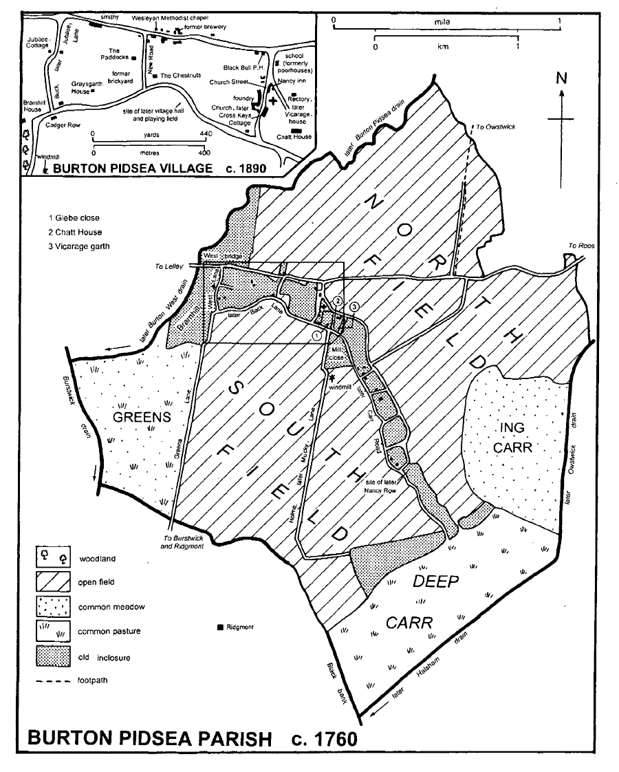
Burton Pidsea parish c.1760
The development of the northern part of the village, which was recognised as enjoying a good 'prospect', (fn. 41) continued in the earlier 19th century, with the building, or rebuilding, of several houses there. (fn. 42) Isaac Raines, surgeon and apothecary of Burton Pidsea, probably lived in the house he bought in 1806, before building Graysgarth House in 1818 on the site of another house and parcels of land amounting to 2 a. which he purchased in that year and in 1819. The house, of grey brick with a slate roof, has a porch supported by two pairs of Tuscan columns and flanked by bows rising through both storeys, and stone, heraldic shields at first-floor level. Called Burton Hall in 1852, (fn. 43) the house was extended to the west in red brick in the later 20th century. Isaac Raines's son-in-law William Clapham (d. 1860) was responsible for Chatt House, an extensive enlargement, probably of c. 1840. (fn. 44) Evidently also about 1840 Edward Baxter, farmer of c. 1,500 a. and racehorse breeder, and his neighbour William Harland, another of the larger farmers, remodelled their houses, later called the Paddocks and the Chestnuts respectively. (fn. 45) As part of their improvements, both men obtained the replacement of one of the side lanes by New Road, c. 200 m. further west, in 1843, (fn. 46) when Baxter built and dated a brick and boulder wall along his side of New Road. Harland presumably then made the undated, lower, boulder wall opposite. (fn. 47) The Paddocks, a red-brick house with a stuccoed parapet, bow windows, and a large porch supported by square pillars, was enlarged with a side wing in the 20th century. Its outbuildings have tie beams with Baxter's initials and the date 1829. The more modest Chestnuts is an 18th-century house refronted and reroofed in slate; the facade is of rendered brick with quoins and has a porch supported by fluted wooden pillars with foliated capitals. The only one of the larger houses certainly built on a new site was Bramhill House. Thomas Ford, farmer, mortgaged its site, Bramer Hill close, and other lands in 1844 for £3,000, and the house was evidently built soon afterwards. (fn. 48) That part of Burton Pidsea had been called 'Bramhulle' in the 13th century and 'Braimehills' in the 17th. (fn. 49) The large house, of grey brick with a slate roof, faces south to take advantage of the view across the falling ground in the south of the parish and beyond. The south facade has a heavy stone porch with square pillars which leads from the house into the remains of a small, well treed park. (fn. 50) Other work of the mid 19th century included the rebuilding by Edward Baxter of a house on Carr Road as five cottages for old people; the terrace, now occupied as one house, was named Nancy Row after Baxter's racehorse. (fn. 51)
There was also a little building north of the main road, now Main Street, a Wesleyan chapel being put up there in 1847 and a brewery by the 1850s, (fn. 52) but the village remained small until the mid 20th century. The rural district council then built c. 20 houses, Bengey Cottages, on the north side of Main Street, (fn. 53) and later, c. 1970, laid out the Glebelands estate, comprising some 70 bungalows, on the opposite side of the road. (fn. 54) Many private houses were also added then and later. Piecemeal 'ribbon' development occurred along both sides of Main Street, but more typical were the small estates made off Main Street, Jubilee Lane, and Back Lane. The earlier buildings were mostly modest, but in the late 20th century many so called executive-style houses were put up in the former grounds of the 19thcentury houses: c. 45 houses were built on land belonging to the Chestnuts; about the same number of larger, mock-Georgian houses in Barley Garth, in the former grounds of the Paddocks; six in Gray's Croft, alongside Graysgarth House, and about 25 in and off Jubilee Lane, among them a row of half-timbered detached houses on part of Graysgarth farm. (fn. 55) The increased size of the village led to the provision of a sewage works beside Burton Pidsea drain in the 1960s, (fn. 56) and by the 1970s electricity and gas stations and a telephone exchange had also been built in Burton Pidsea. (fn. 57)
In the later 18th century there were up to four alehouses in the village. The Black Bull was named in the 1820s, rebuilt in or shortly before 1845, and still traded in 1999. (fn. 58) Cross Keys Cottage is believed to have operated as an alehouse until its closure as a disorderly house in the mid 19th century. (fn. 59) Drink was also served at the blacksmith's, whose house was named by 1852 the Nancy inn, after the renowned racehorse of that name which Edward Baxter bred in Burton Pidsea in the late 1840s. The Nancy inn remained in 1999. (fn. 60) A lodge of the United Ancient Order of Druids, founded in Burton Pidsea in 1863 and recorded until 1938, met at the Black Bull. (fn. 61) A village fair held on the 12th of July seems to have been discontinued in the 1850s (fn. 62) but then revived, extended to include the 11th July, and combined with the annual feast day of the friendly society branch. The latter celebrations included a parade through Burton Pidsea with the village brass band. Other social events in the 19th century included ploughing matches and a weekly game of football, which began at the church door immediately after Sunday morning service. (fn. 63) A village or Church hall, with reading and billiard rooms, was proposed in 1910, (fn. 64) and a 'memorial hall' c. 1920; neither was built then and Burton Pidsea continued to rely for a meeting place on the school until the Memorial Hall was finally put up beside Back Lane in or soon after 1954 on part of a 3-a. site. The rest of the ground has been used for a playing field and a children's playground. Principal users of the hall have included the Women's Institute and of the field the local football and cricket clubs. (fn. 65) In the 1960s a youth club was also held in the village. (fn. 66)
OUTLYING HOUSES. Houses built away from the old village garths on former commonable land included Thimble Hall in North field, put up by 1829 and perhaps renamed, or replaced soon afterwards by, Buzzard Nest. One or two houses, called Greens Farm in 1829 and Salmond Cottage in the 1850s, were similarly put up in the south of the parish. (fn. 67)
MANORS AND OTHER ESTATES.
In 1066 Morkar's manor of Withernsea included 7 carucates of sokeland at Burton Pidsea; they had passed to Drew de Bevrère by 1086 (fn. 68) and were later part of the Aumale fee. (fn. 69) The estate, sometimes called BURTON PIDSEA manor, was a member of Burstwick, the chief manor of the fee in Holderness. (fn. 70) With Burstwick manor, it descended from the counts of Aumale to the Crown and its grantees, reverted to the Crown in 1521 on the execution of Edward Stafford, duke of Buckingham, and then passed by grant to Henry Neville, earl of Westmorland, in 1558 and sale in 1560 to Sir John Constable. The Constables, later viscounts Dunbar, and their successors retained the estate. (fn. 71) In the mid 15th century the estate at Burton Pidsea comprised, besides freeholdings, 72 houses, 5 carucates and 1 bovate, and 287 a. (fn. 72) Little or none of the land was held in demesne from the 13th century, (fn. 73) and the only allotment made to William Constable at inclosure in 1762 was of a few perches, presumably for his consent as lord of the manor. (fn. 74) The rest of his estate then comprised some 1,210 a. of copyhold of Burstwick manor. (fn. 75) The land was enfranchised at various dates, 210 a. being freed in 1857 and 124 a. in 1904, for instance. (fn. 76) The nearness of Burstwick and apparent lack of demesne land in Burton Pidsea probably account for there being no manor house on the Aumale estate there.
A reputed manor of BURTON PIDSEA, with free fishing in Pidsea mere, was bought from Richard Bean and his wife Elizabeth by George South in 1550. (fn. 77) South (d. by 1575) devised his land in Burton Pidsea to his son John. (fn. 78) He had evidently been succeeded by his son, Sir Francis South, by 1606, and in 1610 the latter sold the so-called manor to Walter Aire. (fn. 79)
After the ordination of a vicarage, (fn. 80) the RECTORY belonged to the dean and chapter of York minster. In 1650, during its confiscation by the Commonwealth, the rectory was valued at £108 net, most of the income coming from the tithes and Easter offerings. (fn. 81) At inclosure in 1762 the tithes were commuted for rents totalling some £143 a year, and 168 a. was then awarded for the 4 bovates of glebe land. (fn. 82) The dean and chapter let the rectory for terms of three lives from the 17th century. James Clapham of Hull, mathematician, was involved in the renewal of the lease to Isabella Hutchinson in 1713, possibly for William Clapham, an officer of the Church court at York, who is said to have obtained the lease about that date. The rectory thereafter descended in the Claphams or their relatives (fn. 83) to another William Clapham, who in 1854 bought the freehold of the land from the Ecclesiastical Commissioners, in whom the dean and chapter's estate had been vested in 1852. (fn. 84) It later descended with Clapham's other land. (fn. 85)
The rectory house comprised five low rooms and a large chamber in 1650 and had 2 hearths in 1672. (fn. 86) It was recorded again in 1743 (fn. 87) and, as the 'glebe homestead', c. 1760, when it stood south of the church beside the later Carr Road. (fn. 88) By the 1830s the house had been demolished and two cottages built adjoining its site. (fn. 89)
A small freeholding in Burton Pidsea belonged to Brian Routh (d. 1483), (fn. 90) and later descended like Tansterne, in Aldbrough, to the Cutts (fn. 91) and the Michelbournes. (fn. 92) It was sold to Thomas Chatt in 1647, (fn. 93) and probably passed later to Philip Chatt. (fn. 94) William Clapham seems to have succeeded him by the 1690s. (fn. 95) Besides a house, 'late Chatt's', the Claphams assembled a small estate in Burton Pidsea, largely of copyhold, by piecemeal purchases. At inclosure in 1762 William Clapham's son George was awarded 6 a. and his son George 82 a. (fn. 96) By 1785, when the latter George conveyed the estate to his son William, the copyhold had been enlarged to c. 170 a. (fn. 97) William (d. 1835) left most of the holding to his son Leonard (d. 1839), and the rest to his other son William, who succeeded his brother. (fn. 98) In 1854 William Clapham bought the rectorial estate, of c. 170 a., which had long been held by his family as lessees. (fn. 99) Clapham (d. 1860) was succeeded by his son W. S. Clapham, who in 1872 sold Chatt House with 171 a. of copyhold and 194 a. of freehold to his relative Henry Cautley, a Leeds worsted manufacturer. (fn. 100) Cautley (d. 1897) left the estate in undivided half shares to his sons Edmund (d. 1944) and H. S. Cautley, later Baron Cautley. (fn. 101) In 1946 Lord Cautley and another sold the 368-a. Chatt House farm to Thomas Harrison. (fn. 102) Harrison already had Manor farm and c. 250 a. in the parish, (fn. 103) and about 200 a. was added by other purchases c. 1950. (fn. 104) In 1969 he sold Manor farm with 620 a. in Burton Pidsea to the Equitable Life Assurance Society. (fn. 105) In 1997 R. C. Lewis, Mr. Harrison's step-son, re-purchased the land in Burton Pidsea, which is farmed by T. Harrison (Farmers) Ltd. Chatt House and c. 20 a. were held separately by the family in 1999. (fn. 106)
Philip Chatt had two houses in Burton Pidsea in 1672, neither apparently large, (fn. 107) and a house 'late Chatt's' but then belonging to George Clapham stood south-east of the church in the 1760s. (fn. 108) The Claphams' house was described in the 1780s as 'lately rebuilt', (fn. 109) and it was later extensively enlarged, it is said in 1839 by William Clapham. (fn. 110) Clapham's enlargement comprises a square block in grey brick with stone dressings under a slate roof. The south front has a prominent, semicircular, stone porch with Doric pilasters and entablature, and to the rear part of the older, red-brick house remains. A stable block, now converted into living accommodation, extends east from the house, and further away stands a square, red-brick dovecot, of two storeys with a pyramidal, louvred roof; both are contemporary with the remodelling of the house.
At inclosure in 1762 there were eight proprietors with over 100 a. each in Burton Pidsea, (fn. 111) and some of those holdings were later enlarged by purchase to form sizeable estates. Richard Howard, a Hull merchant, was awarded 172 a. in 1762, and in 1812 his daughter Ann sold an estate by then enlarged to c. 275 a. to Charles Howard and Marmaduke Prickett. The purchasers then also bought 60 a. from another proprietor. (fn. 112) Howard conveyed his half shares in the purchases to Prickett between 1816 and 1837. (fn. 113) Transactions in the 1820s added c. 60 a. to the estate, (fn. 114) and Prickett (d. 1860 or 1861) was succeeded in nearly 400 a. by the Revd. Thomas Prickett (d. 1902). (fn. 115) The estate was sold by the Pricketts in 1912, Charles Wray buying Red House farm, of 231 a., and V. H. Lear 158 a. (fn. 116) In 1913 Red House, later Manor, farm was re-sold to William Thompson (d. 1943), who was succeeded by his great-nephew, Thomas Harrison. Manor farm later descended with Harrison's other land in the parish. (fn. 117)
A manor house, presumably the chief house of one of the freeholdings, (fn. 118) is believed to have stood south of the village, on or near a site which may formerly have been moated, and a farmhouse there was called Red House in the mid 19th century and later, for an unknown reason, Manor Farm. (fn. 119) Manor Farm is an 18th-century house; its outbuildings include a two-storeyed dovecote, also of the 18th century, with a pyramidal roof. (fn. 120)
Another of the larger holdings was based on the estate of the Burtons. Richard Burton who was awarded 145 a. at inclosure in 1762 (fn. 121) may have been Richard Burton (d. 1765), and Richard Burton (d. 1784), who was succeeded in 156 a. in Burton Pidsea by his sister Mary and her husband Napier Christie Burton, his great-nephew. (fn. 122) In the mid 1790s the estate was evidently sold to Thomas and John Turner, from whom Abraham Dunn bought it in 1799. (fn. 123) It was sold to Robert Sayle in 1806. (fn. 124) Sayle (d. by 1832) left the estate, together with c. 50 a. of copyhold, to his nephew Edward Baxter, (fn. 125) who already had a farm of some 30 a. in Burton Pidsea (fn. 126) and added c. 40 a. by purchase in the 1830s. (fn. 127) Baxter (d. 1855) was succeeded by his son William (fn. 128) and he (d. 1877) by his nephews Hugh (d. 1879), Edward, and William Baxter, as tenants in common. In 1892 William and Edward Baxter conveyed the 282-a. estate to F. R. Pease, (fn. 129) who sold it, as Paddocks farm, to Thomas and James Robinson in 1904. (fn. 130) Charles Wray bought the farm in 1911, and sold 158 a. in 1933, Paddocks farmhouse with 117 a. to R. C. Connor in 1944, and The Paddocks with 4 a. of grounds to C. H. Ross, a Hull butcher, in 1945. (fn. 131) The farm was divided and sold, mostly in 1953, 75 a. being bought by Thomas Harrison. (fn. 132) The Paddocks was bought by the present owner, Raymond Beal, in 1971. (fn. 133)
Land in Burton Pidsea and Roos was held by the St. Quintins, and of them by the Ros family in the 13th century. In 1202 Herbert de St. Quintin's tenant, Robert de Ros, occupied the whole 6-carucate holding, of which 2 carucates were evidently in Burton Pidsea. (fn. 134)
Another early estate in Burton Pidsea was that of 1 carucate which William le Gros, count of Aumale (d. 1179), granted to Richard son of Seberin. (fn. 135)
A count of Aumale granted Gamel of Burton, his son Robert, and their heirs an estate in Burton Pidsea, including ½ carucate. (fn. 136) The same or another Robert of Burton was the tenant in 1260, (fn. 137) and it was evidently the same holding which descended from Nicholas Ward (d. by 1323) in turn to his sons Robert (fn. 138) and Henry of Burton. (fn. 139) Henry (d. by 1343) left a daughter Beatrice, (fn. 140) on whose death in 1349 Adam or Henry Ward's daughter Maud was her heir. (fn. 141) The estate was perhaps recorded again in 1377 and c. 1390. (fn. 142)
Two bovates of the Aumale fee in Burton Pidsea were held in the 13th and 14th centuries in return for service as an officer of the lord's court at Barrow-on-Humber (Lincs.). Another tenure by serjeanty involved 1 bovate held for keeping South park, in Burstwick. (fn. 143)
Thornton abbey (Lincs.) had 5 bovates in Burton Pidsea in the early 16th century. (fn. 144) After the abbey's dissolution, the land passed briefly to Thornton college by Crown grant of 1542 and then reverted to the Crown, which sold it in fee farm to John Eldred and William Whitmore in 1611. (fn. 145) Thornton abbey's tenant at Burton Pidsea was William Buckton (d. 1506), of Hackness (Yorks. N.R.), who settled his interest in the land on his sons, Robert and Ralph. (fn. 146) No more is known of the estate. At their suppression in 1540, the Knights Hospitaller had ½ carucate and other land in Burton Pidsea, then occupied by a freeholder. (fn. 147)
ECONOMIC HISTORY.
COMMON LANDS AND INCLOSURE. The open fields lay on either side of the village in North and South fields, which were named in 1610. (fn. 148) Reference to 'forland' in the 13th century may indicate an earlier expansion of the tillage by the taking in of waste land. (fn. 149) An area called the Greens was possibly also part of the tillage, but by the 17th century it seems to have been used primarily as common meadowland and pasture: selions of arable land, meadow, and pasture in the Greens were conveyed in 1649, but other land there was then described as 'meadow or pasture in the far land', and the following year six tenants were appointed to measure and divide meadowland in the Greens. (fn. 150) In 1690 a stint agreed in Fitling manor court, which participated in the agricultural regulation of Burton Pidsea, allowed one pasture gate in winter for each 3 a. held in South field and the Greens, and the same stint was to be applied in South field the following summer, while the Greens was being 'aired'. (fn. 151) It was perhaps, too, the Greens which was called Pasture field in 1728. (fn. 152) Other common meadowland lay in Ing carr, where '½ bovate of meadow' was recorded in 1503, and in Lambert dikes, Southdales, and Turf carr, the last presumably at some time having also been used as a turbary. (fn. 153) The chief common pasture was Deep carr, which was stinted in 1381. (fn. 154) On the eve of inclosure in the mid 18th century Deep carr contained 197 beast gates. (fn. 155) The stint there then seems to have been three cattle, or half that number of horses, for each bovate held. (fn. 156)
Under an agreement of 1760 and Act of 1761, the commonable lands were inclosed by award of 1762. (fn. 157) Allotments made totalled 1,994 a., of which 775 a. came from North field, 597 a. from South field, 235 a. from Ing carr, 199 a. from Deep carr, and 189 a. from the Greens. (fn. 158) There were 43 proprietors, eight of whom received over 100 a. each; they included only three 'local' owners, William Mair of Burton Pidsea, Francis Farrah of Fitling in Humbleton, and John Storr of Hilston. Richard Howard, a Hull merchant, received 172 a., the dean and chapter of York 168 a. for the rectorial glebe and rents of £143 a year for the tithes, Mair 156 a., Richard Burton of Hull Bank in Cottingham, 145 a., Farrah 140 a., Storr 125 a., James Pearson 118 a., and the Mottram family 116 a. There were also six allotments of 50-99 a., ten of 20-49 a., fourteen of 5-19 a., and five of under 5 a.
THE DEMESNE AND TENURES The Aumale estate at Burton Pidsea seems to have produced c. £45 a year in the mid 13th and early 14th centuries. (fn. 159) The assized rents of the free and bond tenants and the cottars were apparently worth £23 in 1269-70, and in 1304-5 they were charged at £37. (fn. 160) The bondmen were said to have held 5 carucates in Burton Pidsea in 1260. (fn. 161) Both they and the cottars were obliged to work on the demesne, and hens and geese were also owed, but those duties may have been commuted for cash payments by the later 13th century. (fn. 162) The unfree tenants also owed tallage, valued at £4 a year c. 1270, merchet, (fn. 163) chevage, (fn. 164) and entry fines. (fn. 165) In the early 17th century, apparently after some dispute and the ruling that the fines were uncertain, some copyholders paid the lord of Burstwick manor sums for confirmation of their estates and a statement of their obligations and rights: the entry fine payable on a change of tenant was declared to be a year's rent; leases for less than two years did not require the lord's licence and no fine was payable; leases for terms above two years or for life were charged at the rate of ½ year's rent. Those tenancies were perhaps distinguished later as 'copyhold freed', as opposed to the majority which were 'copyhold in bondage'. Of the 1,994 a. allotted at inclosure in 1762, 40 a. was copyhold freed of Burstwick manor and 1,170 a. copyhold in bondage; the remaining 784 a. was freehold. (fn. 166).
The demesne land farmed as part of Burton Pidsea in the mid 13th century, and later leased to tenants there, seems to have been mostly at Ridgmont, in Burstwick parish. Demesne lands called 'Bramhulle' and 'Holm', perhaps those later described as 'demesne lands called forland', were probably in Burton Pidsea, but they had already been let for 14s. a year by 1268. (fn. 167) At Ridgmont the demesne belonging to Burstwick manor was said to comprise 240 a. of arable land and just over 100 a. of meadow in 1260, (fn. 168) c. 700 a. in 1340, (fn. 169) 10½ bovates and 200 a. in the 15th century, (fn. 170) and 800 a. extending into Burton Pidsea in the later 16th century. (fn. 171) In the mid 13th century the demesne was being exploited directly, and corn sales contributed to the cash income of Burton Pidsea, just over £11 being charged in 1269-70, for instance. The grazing of the stubble at Ridgmont was sold in 1268, but other pasture there and at 'Estholm' was then being used for the countess's sheep. (fn. 172) Some 150 a. of demesne land was sown and about 40 a. of meadow mown in 1267-8. (fn. 173) Permanent staff on the demesne included two ploughmen and a harrower, but most of the work was apparently done by hired labourers. (fn. 174) Direct exploitation of the estates based on Burstwick manor was being reduced or given up by the 1280s, and in 1287 Burton Pidsea tenants occupied 230 a. of arable land, 117 a. of meadow, and 99 a. of pasture at Ridgmont for rents of c. £21 a year. (fn. 175) In the 15th century the land held by Burton Pidsea men was put at 234 a. of arable land, 28 a. of meadow, and 99 a. of pasture. (fn. 176) The former demesne lands in Ridgmont were conveyed in the Burstwick court rolls, mostly as Burton Pidsea lands. The transfers involved bovates, and Ridgmont field was referred to in 1548. Meadow in 'Hestham', perhaps the earlier 'Estholm', was recorded in 1551, and there seems to have been a stinted pasture in Ridgmont called Rush carr. (fn. 177)
FISHERIES.In 1260 the two halves of Pidsea mere belonged respectively to the count of Aumale, lord of Burton Pidsea, and to (Sir) William de Ros, lord of Roos, but both lords enjoyed the fishing of the whole mere. The count's eel fishery, then said to be worth 5s. a year, was presumably in the mere. (fn. 178) Pidsea mere fishery was let, apparently for 10s. a year about 1270, for 15s. in 1318-19, and for £1 before 1471, when the rent had to be reduced for lack of takers to 10s. (fn. 179) The fishery, then belonging to the Crown as successor to the count of Aumale, had allegedly been fished illegally c. 1300. (fn. 180) In 1335 William de Ros, Lord Ros, was licensed to inclose his half of Pidsea mere, but in 1344 his widow complained that the bondmen of Burton Pidsea had recently made ditches from the mere and were drawing water and fish from it. (fn. 181) Further destruction of the fishing led to tenants of Roos manor being forbidden in 1403 from keeping their ducks on the mere. (fn. 182) A reputed manor of Burton Pidsea included free fishing in the 'water of Pidsey' in 1550, (fn. 183) but that description, and the mere itself, seems to have been lost in the 17th century. (fn. 184) Fishing, presumably in other waters, and fowling in Burton Pidsea were held by a lessee of the lord of the manor in the early 18th century. (fn. 185)
LATER AGRICULTURE.There was said to be c. 695 a. under crops in 1801, and 1,121 a. of arable land and 1,018 a. of grassland were returned in 1905. (fn. 186) Most of the parish was given over to crops in the 1930s, when the grassland was concentrated close to the village and in the south-east of the parish. (fn. 187) In 1987 the area returned for the civil parish, 961.6 ha. (2,376 a.), evidently included some land elsewhere; there were then 927.9 ha. (2,293 a.) of arable land and only 26.3 ha. (65 a.) of grassland. Livestock included nearly 12,600 pigs, almost 500 poultry, and 180 sheep. (fn. 188) In the 19th century and earlier 20th there were usually about ten farms in Burton Pidsea, of which seven in 1851 and three to five in the 1920s and 1930s were of 150 a. or more. (fn. 189) A cowkeeper was recorded in 1851, and from the late 19th century there were up to four in Burton Pidsea. There has also been some market gardening since the 1930s, and about 60 a. bought for that purpose in the 1950s (fn. 190) was still so used in 1999. There was a poultry farm by 1929 and four of them were recorded in 1937, when Burton Pidsea also included two smallholdings. Nine holdings were recorded in 1987, of which one was of 500-699 ha. (1,236-1,727 a.), one of 100-199 ha. (247-492 a.), one of 50- 99 ha. (124-245 a.), three of 10-49 ha. (25-121 a.), and three of less than 10 ha. (fn. 191)
INDUSTRY AND TRADE.The number and type of tradesmen working in Burton Pidsea in the 19th and 20th centuries were typical of a largely agricultural village. Edward Baxter, the largest farmer and proprietor of the village mill in the mid 19th century, was, however, also a brick and tile maker, and a renowned breeder of horses. (fn. 192) The last activity is perhaps reflected in a saddler being employed c. 1850 and in the early 20th century, when there was also a horse breaker in the village. (fn. 193) As a brick and tile maker, Baxter was recorded from 1840 until 1858. His works were close to the Paddocks, the house he is believed to have rebuilt for himself c. 1840, and they may have been established primarily to supply materials for that house, although the yard presumably also provided bricks and tiles for other building operations then under way in the village. (fn. 194) The site of the brick and tile works was evident as a low-lying field in 1999. In 1840 Peter Drew, a beer-house keeper in Burton Pidsea, was also brewing, and he had established Providence Brewery, on the north side of Main Street, by 1852. The business seems to have been given up in the 1870s. As the Old Brewhouse, the building remained in 1999. (fn. 195) William Stamford, wheelwright, had an iron foundry by 1846, and his successor, John Stamford, employed six men in 1851, and was also casting brass and making agricultural machines by 1872. Edward Stamford sold the concern in 1919 to the Holderness Plough Co. Ltd., (fn. 196) which was succeeded by Seward Agricultural Machinery Ltd. The business was sold in 1998, and the premises stood empty and unused in 1999. (fn. 197) One or two other agricultural engineering concerns seem to have worked in the village. Edward Caley, engineer to an Owstwick steam threshing company in 1892, was later recorded simply as an agricultural engineer under Burton Pidsea; in 1921 he was managing the Holderness Plough Co. Ltd., but Caley & Ayre were then separately listed as agricultural engineers. The latter concern had been renamed Caley & Townsend by 1933, and another agricultural engineer, William Stephenson, hitherto a cycle agent, was recorded from 1929. Commerce was largely the concern of one or two shopkeepers, and of the carriers to Hull, one of whom dealt in coal c. 1900. (fn. 198) In 1999 a garage and shop was operated in Main Street, and an automobile engineer, a joiner, and a plumber and heating engineer worked from other premises there; another shop and Post Office traded in Church Street.
MILLS.There was a windmill at Burton Pidsea from the 1260s. (fn. 199) It was perhaps the same windmill which stood in South field in 1616 (fn. 200) and the later 18th century. (fn. 201) It had been demolished by 1852, but its hill was still evident in 1999. The old mill was evidently replaced in 1834 by a tower mill and mill house on a new site beside Greens Lane. (fn. 202) The mill was assisted by steam power by 1889 but it ceased to grind in or shortly before 1901, when its machinery was dismantled. The miller, nevertheless, remained in business, dealing in roller-ground flour supplied from mills in Hull. (fn. 203) The mill was later disused (fn. 204) but the five-storeyed tower remained in the garden of Mill House in 1999.
LOCAL GOVERNMENT.
Burton Pidsea business was conducted in Burstwick manor court, rolls of which survive for 1368-1925. (fn. 205) Besides the conveyancing of copyhold in Burton Pidsea and of former demesne land in Ridgmont, the court dealt with debt pleas, affrays, and breaches of the ale assize in Burton Pidsea. (fn. 206) Officers appointed in the court between the 14th and 18th centuries included 2 constables, 2 aletasters, 2 mill-reeves, 1-4 reeves, or pennygraves, and a pinder, all for Burton Pidsea. Bylawmen at Ridgmont were also mentioned in 1547, and 4 were regularly elected for Burton Pidsea in the 17th and 18th centuries. (fn. 207)
The manor of Fitling, formerly belonging to the Hospitallers, extended into Burton Pidsea, (fn. 208) and agriculture, drainage, and the testamentary affairs of its tenants there were regulated by the court at Fitling. Three bylawmen and a pinder appointed in 1690 at a court held in Burton Pidsea were probably for that village, (fn. 209) and two bylawmen for Burton Pidsea were sworne in 1700. (fn. 210)
Account books of the parish overseers of the poor survive from 1786. (fn. 211) Burton Pidsea built and maintained poorhouses; they were repaired for £35 in 1830 and a datestone of that year, bearing the initials of Edward Baxter and Robert Clapham, the overseers, survives in the wall of the successor building, the school. (fn. 212) In the early 19th century 12-15 people there were on permanent out-relief; 18 in 1802-3 and 5-7 between 1812 and 1815 were also helped occasionally. (fn. 213) Burton Pidsea township, later civil parish, evidently joined Patrington poor-law union in 1836 (fn. 214) and remained in Patrington rural district until 1935, when it was incorporated into the new rural district of Holderness. The civil parish became part of the Holderness district of Humberside in 1974 (fn. 215) and, in 1996, of a new East Riding unitary area. (fn. 216)
Ridgmont, in Burstwick parish, was closely connected with Burton Pidsea in the Middle Ages, (fn. 217) and in the 19th century it lay within the constablewick of Burton Pidsea. (fn. 218)
CHURCH.
A church at Burton Pidsea was recorded, as that of Burton Gamel, c. 1160. By then William le Gros, count of Aumale, or one of his ancestors, had given it to Aumale abbey (Seine Maritime). (fn. 219) In 1228 the abbey ceded the church to the archbishop of York, who assigned it to York minster in 1230. (fn. 220) Burton Pidsea was thereafter in the patronage and peculiar jurisdiction of the dean and chapter of York. (fn. 221) A vicarage was ordained, perhaps twice, apparently in or before 1291 and certainly in 1301. (fn. 222) Following its augmentation in the 1860s with tithe rents formerly belonging to the rectory, the living was sometimes called a rectory. (fn. 223) In 1961 Burton Pidsea vicarage was united with that of Humbleton with Elstronwick, but the two parishes remained distinct. The dean and chapter of York and the Crown, as patron of Humbleton, present alternately to the united benefice. (fn. 224)
In 1291 the vicar was said to have all the oblations, mortuaries, and personal tithes, and some other tithes. (fn. 225) Under the ordination of 1301 he was assigned the whole altarage, or £4 a year from the lessee of the rectory or the dean and chapter, (fn. 226) and for long afterwards almost all of the vicar's income came from a salary paid out of the rectory. It was £6 a year in 1535, (fn. 227) £15 in 1650, (fn. 228) and £25 from the 1660s. (fn. 229) In 1743 the living was said to be worth only £26 10s. a year in all. (fn. 230) In 1809 the dean and chapter augmented the vicarage with the grazing of the churchyard, and from 1818 the curate serving Burton Pidsea also received £10 a year from the parish for providing another Sunday service. (fn. 231) The living was augmented with a parliamentary grant of £200 in 1810 and in 1818 and 1838 with sums of £200 from Queen Anne's Bounty. (fn. 232) Some of the money was used to buy nearly 5 a. in Aldbrough in 1812 and 3 a. in Burton Pidsea in 1822, (fn. 233) and between 1829 and 1831 the income averaged £42 a year net. (fn. 234) In 1868 the rectorial tithe rents, amounting to nearly £143 a year, were annexed to the living by the dean and chapter's successors, the Ecclesiastical Commissioners, who later that year gave £64 a year from the Common Fund. (fn. 235) The rental of the glebe land bought in Aldbrough and Burton Pidsea was £13 a year in 1871, (fn. 236) and the total net income in 1883 was £215. (fn. 237) Some 2½ a. in Burton Pidsea was sold for redevelopment with houses between 1965 and 1967, (fn. 238) and the land at Aldbrough had also been disposed of by 1970. (fn. 239)
At ordination in 1301 the vicar was given ½ a. of the glebe on which to build a house at his own cost. (fn. 240) The vicarage house, then comprising three low rooms, was demolished in the 1650s, apparently by the lessee of the rectorial tithes. (fn. 241) Its garth, extending between the two streets on the east side of the later Chatt House, was the only vicarial glebe until the 19th century. The land was let for 10s. a year in 1716, 15s. in 1777, and £1 in 1809. (fn. 242) In 1868 the Ecclesiastical Commissioners granted £1,400 towards the building of a new house, and in 1869 a 4-a. site between the main road and the church was bought from William Clapham's trustees and the 1/2-a. site of the former house was exchanged with them for an equivalent strip of ground alongside the new site. (fn. 243) The house was built largely in 1869; the stable was added and lesser works of completion done to designs by William Botterill of Hull in or soon after 1871. (fn. 244) The tall, Gothic-influenced house is of red brick with crested slate roofs and heavy, stone, bay windows. From 1948 Burton Pidsea was served from Sproatley and later from Humbleton, whose vicarage house was designated the residence of the united benefice in 1961. (fn. 245) That house was replaced by a new vicarage built in Gray's Croft, Burton Pidsea, in 1980-1. (fn. 246) The redundant vicarage house at Burton Pidsea and its 4 a. of grounds were sold to T. N. Stephenson in 1950. (fn. 247)
Land called 'Gildehustede' was recorded in the mid 13th century, (fn. 248) in the mid 16th the ten ants of Burton Pidsea had a guild house there, and later that house and 1 a. were let by the Crown; (fn. 249) the 'guildhall' and an adjoining croft had evidently passed to Sir Henry Constable, viscount Dunbar, by the earlier 17th century, when he sold them to Richard Wadworth. (fn. 250) The church had lights in honour of St. Mary and St. Zita in 1465, (fn. 251) and an image of St. Mary may have been the object of local pilgrimage in the earlier 16th century. There was also an obit endowed with a house, 2 bovates, and other land. (fn. 252)
Five vicars were inducted between 1412 and 1426, two of them explicitly by exchange, (fn. 253) and the living was being served by a curate c. 1530. (fn. 254) In 1567 Burton Pidsea church still had Roman Catholic fittings and paraphernalia, (fn. 255) and c. 1600 few sermons were preached there. (fn. 256) Ralph Cornwall, vicar of Burton Pidsea from 1662 and also vicar or curate of Skipsea, was accused of drunkeness, brawling, and profanity c. 1665. (fn. 257) The charge in 1663 that a man acted as parish clerk without licence, took away the church keys, and offended the vicar, was presumably part of the same controversy. (fn. 258) Cornwall was still in office in 1671 but had evidently resigned or been removed by 1679. (fn. 259) The lack of a house and poverty of the living (fn. 260) led to vicars' often holding other preferments, living elsewhere, and employing curates in the 18th and earlier 19th century. In 1764 the vicar lived at Burton Agnes, where he was curate, and Burton Pidsea was served for him by the curate at Aldbrough. (fn. 261) A service was held at Burton Pidsea on two Sundays out of three in the mid 18th century; Holy Communion was then administered three or four times a year, with an average of c. 25 receiving at Easter. (fn. 262) Jonathan Dixon, curate from 1781 and vicar from 1786 until his death in 1831, also served Humbleton, Garton, Tunstall, and Elstronwick churches. (fn. 263) Service at Burton Pidsea became weekly in 1818, when the church was once again in the charge of a curate. (fn. 264) One of the curates employed at Burton Pidsea c. 1850 obtained a library of 136 volumes for the parish, but it had been dispersed by the early 20th century. (fn. 265) George Trevor, canon of York minster, chaplain of Sheffield parish church, and from 1868 rector of Burton Pidsea, increased the Sunday services to two. Celebrations of communion, still only quarterly in 1865, soon afterwards became monthly; communion was fortnightly c. 1920, and weekly by 1931. The number of communicants rarely exceeded 12 and on non-festal Sundays in 1931 averaged 5. The congregation in general was said to be growing 'rapidly' in 1868 and 'slightly' in 1877, but in 1931 it averaged only 25. A children's service had been adopted by 1900, but then and later the parish was felt to suffer from its lack of a hall or reading room. In 1931 special services were held on St. Peter's day and for the parades of the friendly society and the golfers of Withernsea Golf Club. (fn. 266) Burton Pidsea was served with Sproatley, Humbleton, and Elstronwick between 1948 and 1953, and thereafter with Humbleton and Elstronwick, with which churches it was united in 1961. (fn. 267) In 1999 a service and a celebration of Holy Communion were provided alternately in Burton Pidsea church on Sundays. (fn. 268) R. M. Lamb, vicar 1886-1921, was an authority on bee-keeping, (fn. 269) and Deryck Goodwin, physicist and vicar from 1986 to 1990, served as the diocesan advisor on church lighting. (fn. 270)
The church's dedication to ST. PETER AND ST. PAUL was recorded in 1542, (fn. 271) but in 1465 and frequently thereafter it was named in honour of ST. PETER alone. (fn. 272) The building, which is set on a mound above the street, is mostly of boulders with ashlar dressings. The original plan of chancel, nave, and west tower has been enlarged to form a near rectangle by the addition of four-bayed north and south aisles embracing the tower, a south chapel alongside the chancel, and a second chapel, or room, now a vestry, on the north side of the chancel. The nave and the core of the tower are probably 12th-century, and an early 13th-century lancet with dogtooth ornament is reset in the east wall of the vestry. (fn. 273) The chancel has an early 14thcentury, two-light window with geometric tracery and a square head. The south chapel, apparently dedicated to the Virgin and presumably housing her image and light, (fn. 274) was added in the mid 14th century; its east window is of three lights with flowing tracery and the two-bayed arcade to the chancel has double-chamfered arches with an octagonal, central pier and simple chamfered capitals. The south aisle was probably built with the south chapel, the eastern respond of the aisle's arcade being identical in design to that of the chapel. The rest of the south arcade was rebuilt, that aisle widened, the north aisle added, and the chancel arch reconstructed as part of a large-scale renovation completed by 1442, when a commission was issued for the re-consecration of the 'newly built' church. (fn. 275) All the arches have two chamfered orders with a hood mould on polygonal piers with moulded capitals. The aisles extend alongside the tower, whose walls have been pierced to provide north and south tower arches; the eastern tower arch was rebuilt last, its capitals varying slightly from those of the arcades. The 15th-century aisle windows are of three super-mullioned lights with two-centred heads; the west windows, which have two lights with reticulated tracery, are probably reset, perhaps from the nave. The south door also has a two-centred head with traceried spandrels in a square frame; the north door, now blocked, is plain.
In or about the earlier 16th century a clerestory was made in the south wall of the nave; a third, upper stage was added to the tower; the south side of the church and the tower were embattled, and the south chapel was given new, three-light windows with depressed heads. The chancel was decayed c. 1600, (fn. 276) and soon afterwards the east window of the north aisle and the tower window were given straight mullions, presumably replacing older tracery, and the former was partly filled with early brickwork. Early brick is also present in the south porch, of uncertain, presumably 15th-century, origin but rebuilt in brick in the 18th or early 19th century, (fn. 277) and in the north 'chapel', also of unknown date. Other changes made by 1831 included the blocking up of the south chapel arches to form a schoolroom, the removal of the battlements from the nave, the replacement of the pinnacles on the south aisle buttresses, and the installation of a west gallery. In 1838 William Clapham, lessee of the rectory, repaired and ceiled the chancel, and rebuilt its east wall in brick incorporating a new three-light window, possibly replacing a trefoiled window of the late 13th or early 14th century. His work evidently also included the rebuilding of the east wall of the nave and at least part of the north chapel. (fn. 278) The church was restored to designs by R. S. Smith of Hull from 1866. The building was refloored, reseated, and refitted; the ceiling of the chancel was taken down and the chancel arch, which it had cut across, repaired; the porch was renewed, and the north chapel remodelled as a vestry. Other work probably included the opening up of the south chapel and the removal of the gallery. Much of the work had been done by 1868, but in 1871 the sanctuary was being floored with encaustic tiles and the chancel roof was still unfinished. (fn. 279) The south chapel was repaired by Joseph Raines in memory of his wife in 1884, (fn. 280) further work done in the chancel in 1892 by Henry Cautley, owner of the former rectorial estate, (fn. 281) and the tower repaired and re-roofed in 1930. (fn. 282) The church was repaired again by Community Rural Aid Ltd. under the auspices of the Manpower Services Commission and rededicated in 1987, (fn. 283) and the nave was re-roofed in 1998.
At inclosure in 1762 the churchwardens were allotted just over 1 a. for church repairs. In 1871 rent of £3 10s. a year was received for the land, (fn. 284) which was sold in 1969. (fn. 285)
A small extension to the churchyard was consecrated in 1907. (fn. 286)
The church has a late-medieval, octagonal font, and a pulpit, partly of alabaster and marble, which was installed at the restoration of the church c. 1870. (fn. 287) Wooden boards displaying the Lord's Prayer, the Creed, and the Ten Commandments, possibly those ordered to be set up in 1663, (fn. 288) were returned to the church in 1987 and 1988 from Chatt House and a local workshop. (fn. 289) The south aisle and south chapel contain several memorials in stained glass and stone to the Raines family, the most notable being a Gothic wall memorial by W. D. Keyworth of Hull to Isaac Raines (d. 1846) and his wife Ann (d. 1853). In the north aisle a matching pair of marble tablets by Bailey & Furness and G. Bailey, both of Hull, commemorate William Harland (d. 1862) and others of his family (d. 1843 and 1859), and in the chancel there are floorstones, stained-glass windows, and mural memorials to the Clapham family, rectorial lessees, and their successors, the Cautleys. (fn. 290) There were three bells in 1552 and later; new or recast bells were obtained in 1677, and two of that peal were recast in 1891. (fn. 291) The plate includes a cup and paten cover, made in Hull in 1638, and other pieces given to the church by the dean of York in 1868, evidently to mark the restoration. (fn. 292) The registers of baptisms, marriages, and burials begin c. 1715 and are practically complete. (fn. 293) Transcripts from 1600 also survive. (fn. 294)
In the 18th and 19th centuries the parish clerk also served as sexton. Besides his fees, the clerk received each year 10d. from every house, 5d. from each cottage, and a corn render from each bovate. The last due was commuted into money rents at the rate of 1s. 9d. a bovate and amounting in all to £5 5s. 8d. at inclosure in 1762. (fn. 295)
NONCONFORMITY.
As was commonly the case in Holderness, Roman Catholic fittings and furnishings were found in the church at Burton Pidsea in 1567, and Michael Bolton, vicar, is said to have resigned or been deprived in 1579 and later to have died a Catholic in Hull. There seem, nevertheless, to have been few Roman Catholics in the parish, c. 10 people or one or two families being so recorded in the early and mid 18th century. Nevertheless they probably included Leonard Sisson, 'gentleman' and lessee of the rectory, and his family, recorded as noncommunicants c. 1600, (fn. 296) and c. 1720 Cuthbert Constable, lord of Burton Pidsea, and three other proprietors there were Roman Catholic. (fn. 297)
Twelve Quakers were presented for nonattendance at church in 1663, among them Philip Chatt, his wife, and a servant, (fn. 298) and the Holderness monthly meeting was held at Burton Pidsea in 1669. (fn. 299) In 1764 there was said to be only one Quaker family in the parish; (fn. 300) it was perhaps a branch of the Stickneys, prominent Friends who lived just outside Burton Pidsea at Ridgmont. (fn. 301)
Thomas Thompson, a leading local Methodist, secured the registration for dissenting worship of Richard Hastings's house in the west end of the village in 1784, and that or other houses, also in the occupation of Hastings, were licensed in 1790 and 1791. (fn. 302) The same or another Richard Hastings obtained the registration of a Wesleyan chapel in 1820. (fn. 303) It was replaced by a new chapel built on the north side of Main Street in 1847. (fn. 304) That building was extended about 1859 (fn. 305) and restored in 1909. The chapel was closed in 1970 and the building demolished after 1980. (fn. 306)
It was perhaps another Richard Hastings who was a prominent member of the Primitive Methodists at Burton Pidsea in the mid 19th century. He fitted up a room for worship by the congregation in the 1840s and was the 'chapel' steward in 1851. (fn. 307) The room had evidently been closed by 1859, when its fittings were being distributed. (fn. 308) The congregation later met in a cottage, but services had apparently ceased by 1893. (fn. 309)
EDUCATION.
Parents sent c. 50 children to day schools in Burton Pidsea in 1818, (fn. 310) and in 1833 there were three schools there, attended by 25 boys and 34 girls. (fn. 311) Former poorhouses in Church Street were remodelled or rebuilt as a school and master's house (fn. 312) in 1860. The parish school, which opened that year, was supported largely by school pence, but the parish subscribed £20 a year and provided the house in return for the master keeping its accounts, and his fees as a land surveyor were also used for the school. Average attendance at the mixed school was 30 in 1866. (fn. 313) The school was run according to the National plan by 1872, when the site and buildings were conveyed to the vicar and churchwardens; that year has since been regarded mistakenly as the building date. (fn. 314) An annual government grant was first received in 1869. (fn. 315) In 1877 the school also accommodated infants and had an average attendance of 60. (fn. 316) It was transferred in 1909 to the county council, which in 1910 enlarged the site, remodelled the school, and improved the house. (fn. 317) Average attendance was usually c. 70 between 1906 and the 1930s but stood at 82 in 1913-14 and 55 in 1937-8. (fn. 318) The senior pupils were transferred to Withernsea High School at its opening in 1955. (fn. 319) Burton Pidsea primary school was enlarged and altered to provide three classrooms in the early 1960s, (fn. 320) a playing field was laid out in 1964, (fn. 321) and in 1975 classrooms for 75 infants were built. (fn. 322) There were 101 on the roll in 1990 and 69 in 1998. (fn. 323)
CHARITIES FOR THE POOR.
None known.