A History of the County of York East Riding: Volume 7, Holderness Wapentake, Middle and North Divisions. Originally published by Victoria County History, London, 2002.
This free content was digitised by double rekeying. All rights reserved.
'North division: Skipsea', in A History of the County of York East Riding: Volume 7, Holderness Wapentake, Middle and North Divisions, (London, 2002) pp. 374-405. British History Online https://www.british-history.ac.uk/vch/yorks/east/vol7/pp374-405 [accessed 25 April 2024]
In this section
SKIPSEA
THE large, coastal parish of Skipsea comprises, besides Skipsea village, known for the extensive earthworks of its 11th-century castle, the village of Ulrome and the hamlets of Bonwick, Dringhoe, Skipsea Brough, and Upton. (fn. 1) There is a church at Ulrome, which is now a separate parish (fn. 2) but in the mid 19th century belonged mostly to the ecclesiastical parish of Skipsea (fn. 3) and is therefore treated here. Two other settlements, Cleeton and Newhithe, have been lost to the sea, (fn. 4) which has continued to reduce the area of the parish. (fn. 5)
In 1852 the ecclesiastical parish of Skipsea contained 5,118 a. (2,071.3 ha.), of which Skipsea township, later civil parish, comprised 1,593 a. (644.7 ha.), that of Dringhoe, Upton, and Brough 1,705 a. (690 ha.), and Bonwick township 774 a. (313.2 ha.). The rest of the parish was in Ulrome township, where 1,046 a. (423.3 ha.) belonged to Skipsea and 548 a. (221.8 ha.) to Barmston parish. (fn. 6) By 1891 erosion had reduced the area of Skipsea to 1,566 a. (633.8 ha.) and of Ulrome to 1,589 a. (643 ha.). (fn. 7) In 1935 Skipsea civil parish, then further reduced to 1,524 a. (616.8 ha.), and that of Dringhoe, Upton, and Brough were combined as the new civil parish of Skipsea. Its area had decreased to 1,279 ha. (3,160 a.) by 1991. A new parish of Ulrome was formed in 1935 from the existing civil parish, then of 1,576 a. (637.8 ha.), the 1,152-a. (466.2-ha.) Lissett civil parish, in Beeford, and 99 a. (40 ha.) of Barmston civil parish. Land was later lost and in 1991 Ulrome contained 1,129 ha. (2,790 a.). Bonwick civil parish was added to those of Bewholme and Nunkeeling and Dunnington, in Beeford, to form the new parish of Bewholme in 1935. (fn. 8) In this article Dringhoe, Upton, and Brough, the boundaries between which are unknown, will sometimes be referred to shortly as Dringhoe, and, unless otherwise said, the name Ulrome will mean the township, chapelry, or ecclesiastical parish, rather than the enlarged civil parish.
Skipsea village is situated 7 km. NNW. of Hornsea, 14 km. ESE. of Driffield, and 1 km. west from the North Sea, which forms the eastern boundary of much of the parish. Ulrome village is 2 km. north of that of Skipsea but has been extended southwards by recent cliff-top development. Evenly strung along a road leading west from Skipsea village to the parish boundary 3 km. away are successively the ham lets of Skipsea Brough, Dringhoe, and Upton, and c. 2 km. south of the village is the shrunken settlement of Bonwick.
The chief settlement in the parish in 1086 was Cleeton. (fn. 9) The name, meaning 'clay farm' or 'clay village', was Anglian. (fn. 10) Cleeton became less important after the development of a new settlement at Skipsea. (fn. 11) From the late 13th century it was Skipsea, not Cleeton, which was named in taxation and other government records, (fn. 12) although the name Cleeton continued to be used for the manor. (fn. 13) Cleeton is supposed to have stood a little more than a mile ESE. from Skipsea village, on land lost to the sea c. 1800. (fn. 14) The position of Clayton Hill Farm, now Far Grange, (fn. 15) supports that location, but the name Cleeton, borne since the the 19th century or earlier by a lane leading north-eastwards from Skipsea village, suggests that the traditional site is incorrect. (fn. 16)
The name Skipsea occurs from the 12th century and is a Scandinavian or Anglo-Scandinavian description of the former mere there, meaning literally a lake navigible by ships. The mere and the sea were probably, then as later, connected by a drain. (fn. 17) Evidence of early habitation in or near the mere includes platforms for huts constructed it is believed in the Stone and Bronze Ages and discovered beside the western boundary drain of Ulrome in the 19th century. (fn. 18) A castle and a church had been built in the mere by the end of the 11th century, (fn. 19) and then or later a village grew up there. The relationship of Skipsea village to the unsuccessful town of Skipsea Brough, or borough, is obscure. The borough of Skipsea castle, recorded between 1160 and 1175, (fn. 20) was perhaps founded by William le Gros, count of Aumale (d. 1179). It was presumably laid out south of the castle precinct, where the defensive bank is interrupted by the beginning of Skipsea Brough's street. No charter is known. Markets and fairs granted in the 13th and 14th centuries were variously for Skipsea town, Skipsea manor, and Skipsea Brough manor, presumably all the same and possibly by then meaning Skipsea village. (fn. 21)
Ulrome was recorded as Ulfram or Ulreham in 1086 and is believed to be an Anglian name altered by Scandinavian influence meaning 'Wulfhere's or Wulfwaru's homestead'. Dringhoe, in 1086 Dringolme, would seem to be a Scandinavian name denoting a hillock occupied by one or more young men or free tenants known as 'drengs'. Upton and Bonwick are Anglian names meaning respectively the 'upper farm' and either 'Buna's dairy farm' or the 'dairy farm near the reeds'. (fn. 22)
Newhithe, or New Hide, whose Anglian name meant the 'new landing place', may have been intended as the port of Skipsea, and Skipsea and 'Hyda' were assessed together in 1334. (fn. 23) Comprising 10 tofts in 1260, Newhithe was losing land to the sea by the 1330s and by the early 15th century much or all of the settlement had been carried away. (fn. 24)
In 1377 there were 95 poll-tax payers at Skipsea and Brough, 42 houses were recorded at Skipsea in 1439, (fn. 25) and in 1672 Skipsea had 43 houses assessed for hearth tax and 26 discharged. At Dringhoe and Upton there were 74 poll-tax payers, and 27 houses were recorded at Upton, which probably also comprised Brough and Dringhoe, in 1672. (fn. 26) Bonwick was combined with Dunnington, in Beeford, the two settlements having a total of 83 payers in 1377 and 12 houses in 1672. (fn. 27) Skipsea parish as a whole was said to have 80 families in 1743 and 67 in 1764. (fn. 28) The population of Skipsea township rose from 220 in 1801 to 290 in 1811, 386 in 1831, and 435 in 1851, but then declined to 394 in 1871, 341 in 1891, and 288 in 1901. Numbers fluctuated in the early 20th century and in 1931 stood at 295. Dringhoe, Upton, and Brough township had 122 inhabitants in 1801; numbers rose to 190 in 1841 but then fell, to 163 in 1851 and 113 in 1911. There were 128 inhabitants in 1931. After the union of Skipsea and Dringhoe, Upton, and Brough in 1935 the population of the new civil parish of Skipsea increased to 472 in 1951, then fell to 396 in 1971 before rising again. There were 515 usually resident in 1981 and 647 in 1991, visitors inflating the numbers counted to 548 and 649 respectively. (fn. 29)
The population of Bonwick township was 31 in 1801 and 1861 but then fell to 20 in 1871 and 14 in 1901. There were 26 there in 1921 and 24 in 1931. (fn. 30)
At Ulrome there were 63 poll-tax payers in 1377, and 32 houses there were assessed for hearth tax and 14 discharged in 1672. (fn. 31) By 1743 Ulrome chapelry apparently had 29 families, 6 of them living in the part of Ulrome which belonged to Barmston parish. (fn. 32) Thirty-five families were recorded at Ulrome in 1764 (fn. 33) and 143 people in 1801. The population rose, notably in the 1830s, to stand at 220 in 1841 but later fell, to 194 in 1881 and 157 in 1911. In 1931 the population was 153. The area comprised in the new civil parish of Ulrome had 254 inhabitants in 1931, including 6 in Barmston. Numbers grew to 383 in 1961 but then fell. There were usually 249 residents in 1981 and 254 in 1991 but visitors resulted in 263 and 286 respectively being counted. (fn. 34)
Skipsea and Ulrome lie mostly on boulder clay, with alluvium alongside the main streams and deposits of sand and gravel which produce small hills, notably to the south of Skipsea village. (fn. 35) From less than 8 m. above sea level beside the main drains in Ulrome, Dringhoe, and Skipsea, the land rises to c. 25 m. in the southern half of Skipsea. The rolling ground ends in the east in a virtually uninterrupted line of crumbling cliffs and its rises and hilltops were used as the sites of most of the settlements and farms.
For most of their drainage Skipsea and Ulrome depend on Barmston Main drain which carries water into the North Sea. The drain was made from ancient streams flowing along the northern and western boundaries of Ulrome and the northern limit of Dringhoe; they carried some of the water into the sea, as now, but the rest formerly drained westwards and southwards into the valley of the river Hull. (fn. 36) The stream between Barmston and Ulrome and its continuations across the north-west corner of Ulrome and down the boundary between Lissett and Ulrome and Dringhoe were all mentioned as insufficient in 1367. (fn. 37) That drainage pattern was changed radically c. 1800 by the Beverley and Barmston Drainage commissioners, appointed under an Act of 1798; they improved the streams as the Barmston Main drain and diverted all of the water into the sea at Barmston. According to the drainage award of 1811, the improvements benefited 249 a. in Skipsea and Dringhoe and 120 a. in Ulrome. (fn. 38)
Barmston Main drain is fed by Skipsea drain, part of a lengthy watercourse called Stream ditch or dike which formed the boundary between Dringhoe and Ulrome and further south between Bonwick and Skipsea. As well as draining much of the parish, Stream dike also collected water from the higher grounds to its south. Stream dike has also been known as the Scurf in Ulrome, which is separated from Skipsea by a tributary stream called Sewer dike. (fn. 39) Sewer dike was recorded in the later 16th century as Ulrome or New dike, which then flowed between Ulrome and Skipsea from the mere to the sea. (fn. 40) Stream dike, which evidently also fed the mere around the castle, was insufficient in 1367, especially to the south of Skipsea village. (fn. 41) It was mentioned again as the ditch or 'little river' flowing east of the castle site in 1546. (fn. 42) The course of Stream dike across the low grounds near the village was later embanked, perhaps either about the date of inclosure in 1765, when drains awarded included a new one south of the village, or c. 1800 by the Beverley and Barmston Drainage commissioners. (fn. 43) Skipsea mere evidently disappeared during the Middle Ages, but another mere remained beside Stream dike in the south-western corner of Skipsea in the 1760s. (fn. 44)
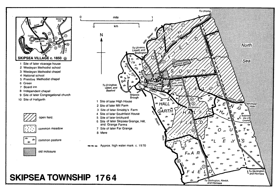
Skipsea township 1764
The chief roads in Skipsea and Ulrome connect those villages to the road from Beverley and Hull to Bridlington which is carried over the main drain in the north-western corner of Ulrome by Lissett New bridge. (fn. 45) One road leads westwards from Skipsea through Dringhoe and Upton to join the Bridlington road at Beeford, the other north-westwards by way of Ulrome to meet the main road near Lissett. The stretch from Ulrome included a part called Allison Lane, named in 1760, and the junction there is known as Allison Lane End. (fn. 46) The road through Ulrome was widened in the mid 20th century. (fn. 47) From Allison Lane End a minor road, formerly part of the main road, continues to Lissett. (fn. 48) Another road, Hornsea Road, leads east from Skipsea and then south to Atwick and Hornsea, lesser roads run south from Skipsea Brough to Bonwick, Bewholme, and Dunnington, and eastern lanes connect both villages to the sea and to each other. The Skipsea to Atwick road was one of several in Skipsea and Ulrome which were made, or given straighter courses, at inclosure in the 1760s, and one of the eastern lanes, Mill Road, later Lane, was then given a new entry into Ulrome, further inland. A coastal road made then later comprised Cliff and Green Lanes. (fn. 49) Apart from the route by Allison Lane End, Ulrome village has been connected to Barmston by one or two field roads since the 18th century. (fn. 50) In the 1870s omnibus services ran to Bridlington, Driffield, and Hornsea, and there were carriers to those towns and Hull and Beverley. (fn. 51)
SKIPSEA village was built c. 300 m. east of the castle, with which it was connected by a causeway across the mere. (fn. 52) From the church at its western end, the main street leads eastwards, probably in the Middle Ages into a funnel shaped green used for the village's markets and fairs. (fn. 53) The green had been reduced by building before 1471, (fn. 54) and by the 18th century most of that space was occupied by an island of houses and garths, separating the street from a northern back lane. It may have been the back lane which was recorded in 1577 as Finkle Street. (fn. 55) The small green which remains formerly included a pond called the Weir. (fn. 56) Side lanes from the street lead north to Ulrome and south, one formerly giving access to the village's meadows, and the other crossing low ground by another causeway to Brough and Beeford. (fn. 57) The village seems to have had an east end, an isolated group of old inclosures a short distance from the village being known as Eastend garths. They stood south of a lane which formerly ran along the northern edge of the village, possibly joining at its western end the causeway road from the castle; in 1997 the lane was represented by Cleeton Lane and a disused, sunken course to the west of Mill Lane. In the 20th century the village has been extended eastwards by the building of houses on Hornsea Road and along Cleeton Lane, (fn. 58) much piecemeal infilling of the older streets has taken place, and small, private housing estates have been developed behind Main Street and Hornsea Road.
The village buildings include several farmhouses. There are about ten boulder-built cottages (fn. 59) and cobble walling is also found in the outbuildings of the farms and around gardens but otherwise the village is of brick. The older buildings mostly date from the 19th century, and the newer include c. 30 council houses.
In the later 18th century up to four houses were licensed at Skipsea, but there was only one there by the 1820s, the Board, which still traded in 1997. (fn. 60) There were several friendly-society branches at Skipsea. The Independent Order of Rechabites' Teetotalers Victory Tent, founded in 1838, had closed or left the order by 1851, and an Oddfellows' lodge established in 1839 was dissolved in 1848. Skipsea Benevolent Friendly Society, also called the Poor Man's Friendly Society, was begun in 1865 or 1866. It met at the Board inn, (fn. 61) and held an annual feast day in the village, before being wound up c. 1950. (fn. 62) The Rechabites seem to have used part of the Independent chapel in Leys Lane, apparently added for them and the Sunday school in 1839. (fn. 63) After the chapel's replacement, the whole building evidently came to be called the schoolroom or the Tent. (fn. 64) It was used in the late 19th century as a reading room and later by a youth club, the W.I., and other groups; it was demolished after 1952 and houses have been built on the site. (fn. 65) A house and shop at the west end of the green bought in 1904 and neighbouring properties acquired in 1915 and 1920 were evidently rebuilt or remodelled to serve as a reading and recreation room. (fn. 66) The room fell into disrepair but was restored and in 1991 re-opened as a village meeting hall. (fn. 67) Another meeting place is the pre-fabricated building put up beside Cleeton Lane by Skipsea Arts Group in the 1950s and sold in 1960 for use as the village hall. (fn. 68) In the mid 20th century the county council provided a library in the reading room and the village hall, then called Windsor Hall, and the former was also used by a bank. (fn. 69) Two acres on the north side of Cleeton Lane, awarded to the lord of the manor at inclosure for the pasture rights enjoyed by his pennygrave, or rent-collector, were used with 9 a. south of the lane as allotment gardens from the late 19th century until c. 1940. Their common use probably accounts for the larger plot, later used for council housing, being called Pennygraves and the smaller the Half Pennygraves. (fn. 70)
OUTLYING BUILDINGS. Away from the village, farmhouses were built on the former commonable lands after inclosure in 1765; High, or Cliff, House, Mill Farm, Smiddy's Farm, Southfield House, Skipsea Grange, Hill Farm, Grange Farm, and Far Grange, or Clayton Hill Farm, had all been put up by the 1820s. (fn. 71) Recent additions include a group of farms just over the boundary with Ulrome. (fn. 72)
Skipsea began to be developed as a seaside village in the 1930s, when many shacks were put up along Cliff and Green Lanes, and tea rooms and a cliff-top café were opened. (fn. 73) The more intensive development of the cliff in Ulrome extends into the north-east of Skipsea, (fn. 74) while near the southern boundary a large caravan park, a leisure centre, and a 9-hole golf course had also been established by 1997. Far Grange caravan park could then accommodate almost 1,000 static and touring caravans. (fn. 75)
Three beacons stood in Skipsea and Ulrome in the 16th century, (fn. 76) and South beacon at Skipsea was mentioned in 1594. (fn. 77) An aerial firing and bombing range at Skipsea, established by the Air Council in the late 1920s, was sold in 1961. (fn. 78)
ULROME village has a plan typical of Holderness, being built along a single street which extends east-west for over 1 km. From its western end, side lanes leading to Lissett and Skipsea now form part of the Bridlington-Hornsea road, isolating the end of the street which is known as Bugg Lane. The village's buildings were grouped at either end of the street, possibly reflecting the early division of Ulrome between two manors. Those at West End include the church, the former vicarage house, (fn. 79) Manor House, (fn. 80) and Ulrome Hall. West End was evidently built around a green, one part of which remains next to the village pond, and others perhaps in the grass verges of Bugg Lane. There was probably also a green at East End, where a tiny triangle of grass survives at the junction of the main street and a side lane. Mention of former garths and crofts in 1793 suggest that the village had declined by that date. (fn. 81) Until its inclosure in 1767 the southern open field extended up to the village street, (fn. 82) and the south side remains relatively unbuilt.
Most of the buildings are of brick and date from the 19th and 20th centuries. Besides the church, older buildings may include a singlestoreyed cottage and the outbuildings of several farms, all boulder-built. The Old Joiner's Shop, comprising a house and converted barn, is mostly of brick and pantiles with some cobble walling to the barn; it may date from the mid 18th century. (fn. 83) Prefabricated houses put up by the rural district council c. 1950 were demolished about 1985, and in 1997 the site was being used for private houses. The council also built eight other houses, which remain, (fn. 84) besides making the usual improvements to the sewage system. (fn. 85)
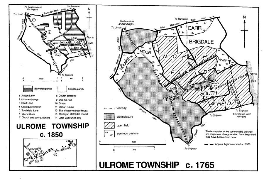
Ulrome township c. 1765 and c. 1850
One or two alehouses had been licensed at Ulrome in the later 18th century, (fn. 86) but none were mentioned later. Allotment gardens made from land belonging to the poor and the church by the late 19th century were used until the mid 20th. (fn. 87) Other land, adjoining the village pond and possibly taken in from the green, was similarly used in the mid 20th century under the name Wyre gardens. (fn. 88) A village hall for Ulrome, called Rickaby Hall, was built in 1952. (fn. 89)
OUTLYING BUILDINGS. After inclosure in 1767 former open-field land was used for the sites of Ulrome Grange and one or two houses beside Southfield Lane, all apparently built c. 1840. (fn. 90)
In the mid 20th century caravan parks were laid out at the east end of the village, and by 1997 the cliff-top parks and buildings serving them stretched southwards more or less without a break along both sides of Southfield Lane into Skipsea. (fn. 91) The facilities of the largest concern there, Skipsea Sands Holiday Village, then included swimming pools and a licensed house, the Sportsman, which, together with the nearby Skipsea Beach social club, was opened c. 1940. (fn. 92) The parks in Ulrome and Mill Lane, Skipsea, had room for c. 1,890 static and mobile caravans in 1997. (fn. 93)
A coastguard station had been built at the end of Sand Lane, which continued the village street to the sea, by 1829. After 1890 it was rebuilt further inland, at the junction of Sand Lane and Southfield Lane, the cliff road, together with 4 cottages. (fn. 94) Five coastguards were employed in the mid 19th century, three or four c. 1900, but later only one or two, and the station was evidently closed about 1930. The cottages remained in 1997. There was also a rocket life-saving apparatus at Ulrome manned by volunteers c. 1900. (fn. 95) Troops were stationed in Ulrome in the First World War, (fn. 96) and buildings put up by the military authorities c. 1940 remain near the cliff in both Ulrome and Skipsea.
SKIPSEA BROUGH,DRINGHOE,AND UPTON. The alignment of Skipsea Brough's street with an entrance into the bailey of Skipsea castle and two long, narrow garths on the street's east side substantiate its probable origin as a 12thcentury planned town. (fn. 97) Dringhoe and Upton were probably also built along single streets. The line of house sites and closes following the higher ground was broken in Dringhoe and between that settlement and Upton by the shallow valleys of streams, and some of the lower ground formed a green at the east end of Dringhoe. Upton lay on either side of the Skipsea-Beeford road in Forker garths and east of Low Upton Farm but those sites were largely abandoned after inclosure. In 1997 earthworks marked the sites of some of the former buildings. (fn. 98) The streets of all three hamlets may together have formed the early road between Skipsea and Beeford, but by the mid 18th century Dringhoe's street had evidently been superseded by a more direct road further south connecting Brough to Upton, and at inclosure in 1763 two lanes running between the garths at Dringhoe from the northern to the southern field were also stopped up. A footpath from Upton to Dringhoe awarded at inclosure may have followed the line of the old road. (fn. 99) Crow Garth, or Grange, Dringhoe Hall, Dringhoe Manor House, Dringhoe Grange, Happy Lands, and Low Upton all occupied garths in 1762, but Field House Farm, then shown on commonable land in South field, was almost certainly a recent addition. By 1829 Upton House, or Park Farm, and Tithe Farm, later Low Fields, had also been built on land inclosed in 1763. (fn. 100) Happy Lands Farm was re-fronted by Jeremiah Lamplugh in 1810; (fn. 101) he also built a windmill and probably the mill house, now Southfield House. (fn. 102) Manor Farm, Dringhoe, was added in 1882. (fn. 103) Field House Farm, Low Upton Farm, Low Fields, and Dringhoe Grange had all been rebuilt by 1997, when the rebuilding of Dringhoe Manor House was almost complete; older outbuildings remained on the farms. More recent houses include two council houses, built on the Beeford road at Dringhoe in the mid 20th century. (fn. 104) In contast to the scattered farms of Dringhoe and Upton, Skipsea Brough comprises a dozen closely-built houses. They are of brick and mostly date from the 19th and 20th centuries.
There was an unlicensed alehouse at Dringhoe in 1756. At Skipsea Brough there was usually one licensed house in the later 18th century, and the Ship was recorded in the 1820s; (fn. 105) it was perhaps the same house which later traded mostly as the Buck inn until its closure c. 1910. (fn. 106) Unused parts of a plot of land at Skipsea Brough acquired for a burial ground have been let as allotment gardens since the 1920s; in 1997 there were 16 gardens and a small field rented to a farmer. (fn. 107)
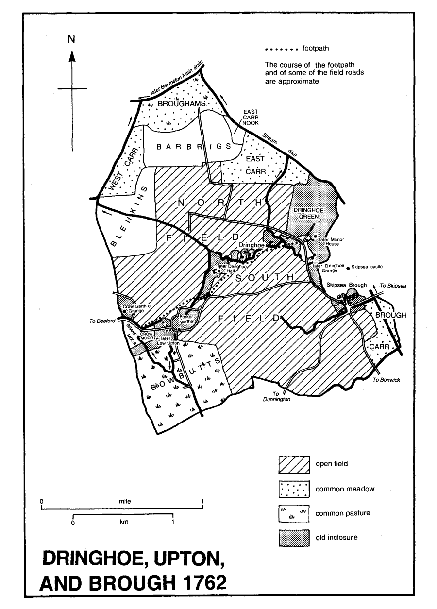
Dringhoe, Upton and Brough 1762
MANORS AND OTHER ESTATES
In 1066 Earl Harold had the manor of CLEETON, comprising 28 carucates and 1½ bovate there, 5½ carucates of sokeland at Dringhoe and Upton, and a berewick of 2 carucates at Wilsthorpe, in Bridlington. By 1086 Drew de Bevrere held the manor. (fn. 108) Cleeton evidently descended like Burstwick, of which it was accounted a member by the 14th century. (fn. 109) It thus passed from Drew de Bevrere in turn to the counts of Aumale, (fn. 110) the Crown, (fn. 111) and its grantees. The last included Geoffrey le Scrope who briefly held Cleeton manor by grant of 1335. (fn. 112) By the attainder in 1521 of Edward Stafford, duke of Buckingham, heir to one of the 14th-century grantees, the former Aumale fee in the parish, with the rest of the lordship of Holderness, was forfeited to the Crown, which granted Cleeton manor to Sir Anthony Browne in 1530. (fn. 113) It was bought back in 1537 (fn. 114) but in 1544 was sold to Robert Raynolde, Robert Whetstone, and other citizens of London. (fn. 115) In 1546 the other purchasers quitclaimed the manor, held of the Crown as 1/20 knight's fee, (fn. 116) to Whetstone, (fn. 117) who also purchased land at Dringhoe and Skipsea. He (d. 1557) was succeeded by his son Robert, (fn. 118) who sold Cleeton manor with appurtenances in Dringhoe, Upton, and Brough to Ralph Bosville and his son Henry in 1565–6. (fn. 119) Henry Bosville had succeeded his father by 1581, and in 1589 he sold the manor to Tristram Conyers. Conyers (d. 1619) (fn. 120) was evidently followed by his widow Elizabeth, and by 1623 his nephew William Conyers had Cleeton manor. In 1628 he sold it to John Wright for Henry Constable, viscount Dunbar, and the manor later descended, with Skipsea manor, in the Constables. (fn. 121) Courts were, nevertheless, held by the Wrights until 1662, and between 1674 and 1694 by Sir Ralph Warton and Vincent Grantham, presumably also Constable trustees. (fn. 122)
SKIPSEA manor was evidently at first merely part of Cleeton manor. It was called a manor in 1276 (fn. 123) but its relationship to Cleeton manor was still uncertain in the 1330s. (fn. 124) Soon afterwards Skipsea was again recorded as a separate manor, (fn. 125) and the manor of Skipsea Brough, mentioned in 1343, was presumably the same. (fn. 126) By the late 14th century Skipsea was clearly the more important of the two manors, Cleeton sometimes being regarded as a mere appurtenance of Skipsea manor, rather than a separate manor. (fn. 127) Skipsea castle was the head of the honour of Aumale in Holderness (fn. 128) before the 13th century, when it was succeeded as the administrative centre of Holderness by Burstwick. (fn. 129) Skipsea descended with Cleeton, its fellow member of Burstwick. (fn. 130) Arnulf de Montgomery (deprived 1102) apparently held Skipsea castle, (fn. 131) and in 1316 Margaret de Gavaston, countess of Cornwall, probably held Cleeton manor as well as its members of Skipsea and Newhithe, of which she was then recorded as lady. (fn. 132) When the Crown alienated Cleeton manor in 1530, (fn. 133) it retained Skipsea manor and its appurtenances in Ulrome and Dringhoe, and they continued to descend with the lordship of Holderness, passing by Crown grant in 1558 to Henry Neville, earl of Westmorland, (fn. 134) by sale of 1560 to his son-in-law Sir John Constable, (fn. 135) and thereafter in Constable's successors, of whom Henry Constable, viscount Dunbar, re-united Cleeton manor with the rest of the fee by purchase in 1628. (fn. 136)
It was claimed that Cleeton manor was wholly or largely occupied as demesne until the mid 15th century; the copyholders at Skipsea were then said to have leased the demesne, adding it to their bond holdings and, in the 16th century, taking advantage of stranger lords to secure admissions to the former demesne land as copyhold. John Wright's claim c. 1630 to the land at Cleeton as his freehold seems to have been unsuccessful, (fn. 137) and later the only land held by the Constables and their heirs, lords of Skipsea and Cleeton manors, was the 2-a. allotment awarded to William Constable at the inclosure of Skipsea in 1765 for the pasture rights of his pennygrave, or rent-collector. Copyhold allotments in Skipsea belonging to Cleeton manor then totalled 770 a. and those of Skipsea manor 612 a., (fn. 138) and the latter manor included c. 18 a. more of copyhold at Brough. (fn. 139) Some 200 a. was enfranchised in Skipsea c. 1780, (fn. 140) about 60 a. in 1890, (fn. 141) and 153 a. in 1908. (fn. 142) The rest of the land was freed in the 1920s and 1930s. (fn. 143)
Skipsea Castle Earthworks
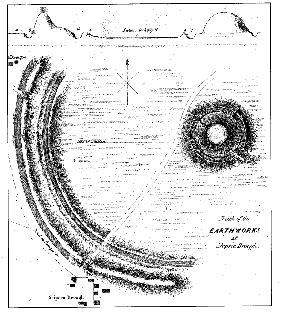
A motte and bailey castle was built at Skipsea soon after the Conquest, it is said by Drew de Bevrere. (fn. 144) It was recorded but not named c. 1100 with its church. (fn. 145) Military tenants on the Aumale fee held land by the service of guarding the castle (fn. 146) but that obligation was later commuted to a money rent. (fn. 147) Skipsea castle is believed to have been disused by the early 13th century, (fn. 148) and in 1221 it was ordered to be destroyed because of William de Forz's rebellion. (fn. 149) Presumably anachronistically, the castle continued to be recorded into the 15th century. (fn. 150) Wapentake courts may have been held occasionally at Skipsea castle until the mid 13th century, and the sheriff's tourn for the North division of Holderness was held at Skipsea or Skipsea Brough c. 1600. (fn. 151) After the demolition of the castle, its site of nearly 20 a. was used for pasture. (fn. 152) It seems to have been encroached upon, and in 1397 the 'castle' was said to be waste and of no net value. (fn. 153) The surviving earthworks comprise the motte, a conical mound c. 90 m. in diameter at the base and c. 12 m. high with a ditch around it, and lower banks enclosing a crescent-shaped bailey on higher ground to the west of the motte. (fn. 154) A bank also remains on the east side of the castle site but otherwise the complex was evidently protected by the mere, fed by streams flowing close to the motte and along the western side of the bailey. (fn. 155) The only evidence of building is a stretch of cobble walling on the side of the motte.
After the demolition of the castle, the counts of Aumale may have lived in Cleeton manor house, (fn. 156) and during the Crown's possession of Holderness the king evidently stayed there. (fn. 157) The manor house was presumably Hallgarth, situated on a small hill just south of Skipsea village. The site may have been moated. (fn. 158) The chapel, hall, and great or high chamber of the house were mentioned in the 13th and 14th centuries, (fn. 159) but by the 16th only the brick foundations remained. (fn. 160)
One of the larger copyhold estates in Skipsea belonged to the Johnsons. Francis Johnson (d. by 1658) was succeeded by his son James in 1 carucate and 1½ bovate and several houses. (fn. 161) James Johnson, who also held land in Ulrome, and his wife Mary sold a house and 1 carucate and 5 bovates to John Pockley in 1673. (fn. 162) Pockley (d. 1679 or 1680) was succeeded in 1680 by his nephew, George Pockley, but in 1682 John's widow Mary (prob. d. c. 1710) was also admitted. Robert Pockley, probably the son of John Pockley's nephew Thomas, had the estate from 1712 until 1743, when he sold it to his brotherin-law Fountayne Osbaldeston. Osbaldeston bought other land in 1758, (fn. 163) and at inclosure in 1765 he was awarded 240 a. (fn. 164) The estate descended under the will of Osbaldeston (d. 1770) in turn to his great-nephew Humphrey Brooke, later Humphrey Osbaldeston (d. 1835), Bertram Mitford, later Bertram Osbaldeston-Mitford (d. 1842), great-grandson of Fountayne Osbaldeston's sister Mary Mitford, and then to Bertram's brother Robert Mitford. (fn. 165) Under the Mitford Estate Act of 1854, (fn. 166) Skipsea Grange farm with 151 a. and an 83-a. farm were sold in 1855 to William Hornby (fn. 167) (d. 1871). In 1889 Hornby's heirs released the estate to the trustees of the mortgagee, Sir James Walker, Bt. (d. 1883). (fn. 168) The farms were enfranchised in 1908. (fn. 169) In 1912 Sir Robert Walker, Bt., divided and sold the estate at Skipsea, Mary Simpson buying Skipsea Grange farm with 179 a. (fn. 170) Mrs. Simpson (d. 1919) was evidently succeeded by Susannah Nattriss (d. 1926) and Susannah's brother J. H. Nattriss. The Air Council bought 122 a. in 1928, and John Rafton the farmhouse and 52 a. in 1929. Skipsea Grange farm descended to Mary Rafton (d. 1967), whose successor was Joan Wray; it still belonged to the Wrays in 1997. (fn. 171)
Land at Skipsea Brough belonging to the Aumale fee was held in the 14th century by the Lorrimer family in return for their service at the wapentake court. (fn. 172)
In 1066 Thorkil and Thorsten held two manors of ULROME with 2½ carucates. They passed to Drew de Bevrère (fn. 173) and were later part of the Aumale fee. Ulrome was later reckoned to contain 4 carucates. (fn. 174)
In 1086 Drew's estate at Ulrome was held by Erenbald. (fn. 175) Most of the Aumale fee there was later held by a family named from the place. Its members may have included an abbot of Meaux and the 14th-century artist-monk John of Ulrome. (fn. 176) The first-known tenant of the 3carucate holding at Ulrome was Adelin, who was succeeded by his son Ralph of Ulrome between 1150 and 1170; a rent of 30s. a year payable to the count of Aumale from the estate was assigned by the count to Bridlington priory soon afterwards, when the count of Bridlington priory soon afterwards, when the tenant was named as Robert of Ulrome, perhaps Ralph's son. (fn. 177) Robert's son Ralph occurred in the late 12th century, (fn. 178) and another (Sir) Robert of Ulrome had the estate in the mid 13th. (fn. 179) The 3 carucates may have been partitioned in the 13th century for the rent owed to Bridlington priory from the Ulrome family's part was later only 15s. (fn. 180) About 1260 Adam of Hornsea held 1½ carucate and William of Buckton the same. (fn. 181) (Sir) Adam of Ulrome, perhaps the same as Adam of Hornsea, was, nevertheless, given as the tenant of all 3 carucates in 1284–5, (fn. 182) but in 1302–3 the holding was shared between (Sir) William of Buckton and John of Ulrome, probably in succession to his father, Hugh of Carlisle. (fn. 183) John of Ulrome was recorded as one of the two lords of Ulrome in 1316, and in 1322 after his death he was found to have held ULROME manor of William de Ros, Lord Ros, and Bridlington priory. His son Hugh inherited the manor. (fn. 184) Part of the land was settled for life on John of Ulrome, another of John's sons. Hugh (d. 1352) was succeeded in almost 2 carucates at Ulrome by his son William, (fn. 185) who further divided the holding by grant of a moiety to Geoffrey St. Quintin and his wife Constance. The part remaining to William of Ulrome's son William in 1367 comprised four houses, a mill, 1 carucate and 3½ bovates, and pasture land. (fn. 186) Land of the Ros fee, and possibly other land, passed from the Ulromes to the Grimston family, tenants at Ulrome in the 1530s, (fn. 187) and later to six freeholders of Roos manor. (fn. 188) Their holdings have not been traced.
The Bucktons' share of Ulrome evidently descended to Constance de Shulton (d. 1349). It then comprised 1 carucate and 2 bovates and ten tofts, held of the Crown as successor to the counts of Aumale as 1/40 knight's fee and by payment of 15s. a year to Bridlington priory, 3 bovates held of the Roses, and the same of the Greystokes. Her son Sir Richard de Shulton (fn. 189) and William of Buckton's son John settled it on Shulton for life in 1356, and in 1359 John of Buckton granted the reversion to John of Wallewyk, his wife Margaret, and their heirs. (fn. 190) It was apparently that estate which the Goxhills had in the 16th century. Comprising 1 carucate and 2 bovates, houses, and meadow land held under the Crown's manor of Burstwick as 1/45 knight's fee and a house and 2 bovates belonging to the Ros fee, it descended from Robert Goxhill (d. 1529) to his son Henry (d. 1550), who left two infant daughters Joan and Gertrude. (fn. 191) The Goxhills' estate was said to have passed to Leonard Robinson (fn. 192) and presumably descended with his other land in Ulrome. (fn. 193)
The Fauconbergs held 1 carucate at Ulrome. Walter de Fauconberg endowed Nunkeeling priory with land there c. 1200. (fn. 194) W. de Fauconberg, recorded as the tenant in the mid 13th century, (fn. 195) was perhaps Walter de Fauconberg, later baron Fauconberg, who held the estate at Ulrome by the 1280s. (fn. 196) The land later descended with the Fauconbergs' estate at Dringhoe and with Rise manor to Ralph Neville (d. 1425), earl of Westmorland, and his successors. (fn. 197) In 1624 three freeholders, including Leonard Robinson's heirs and Christopher Hartas, held 4 houses, 6 bovates, and other land as appurtenances of Rise manor. (fn. 198)
Land in Ulrome held by the Brus family may have passed to the Roses as coheirs. (fn. 199) William de Ros, later Lord Ros of Helmsley (Yorks. N.R.), held 1 carucate of the Aumale fee there in 1287. (fn. 200) The estate descended as a member of Roos manor in the Roses, Lords Ros, (fn. 201) and their successors, the Manners family, earls of Rutland, and the Cecils, earls of Exeter. (fn. 202) A rental of Roos manor dated 1558 almost certainly includes later details and exaggerates the size of the Ros fee there. (fn. 203)
The relationship of William de Wyvill, named as the second lord of Ulrome in 1316, with the preceding estates is unknown. (fn. 204)
Thomas Lacy (d. 1525) held part of the Ros fee as a manor of ULROME. He was succeeded in turn by his son Robert (d. 1556) and grandson Brian (d. 1579). Brian's widow Elizabeth and sons William and Robert (fn. 205) sold the manor, together with the advowson of Ulrome chapel, to Leonard Robinson the elder in 1582–3. (fn. 206) Robinson's estate at Ulrome evidently included other land. (fn. 207) When Leonard Robinson, perhaps the purchaser, died in 1600, he was said, probably inaccurately, to have held the manor with nearly 4 carucates under Rise manor as 1/20 knight's fee. Ulrome manor later evidently descended from father to son in Leonard Robinsons of Newton Garth (fn. 208) until 1657, when it and the advowson were said to have been bought by George Hartas. (fn. 209) John and William Hartas had, however, been dealing with part of the estate, and the advowson, as early as 1600–01, (fn. 210) and George's father, Christopher Hartas (d. 1626), had held a free rent, the advowson of Ulrome chapel, eight houses, over 1 carucate of open-field land, and many closes in the township. (fn. 211) George Hartas (fl. 1663) (fn. 212) was probably succeeded by his son Joseph. By the marriage of Joseph's sister Alathea to Thomas Shipton, or by a sale of 1699, the Ulrome estate passed to Shipton. (fn. 213) After his death the manor was sold in 1717 to Giles Rickaby, a Bridlington merchant. It then comprised a farm with 3½ bovates, and other houses and closes. (fn. 214) Rickaby (d. 1729) and his son John enlarged the estate by piecemeal purchases, one, of 1762, including 4 bovates. (fn. 215) John Rickaby (d. 1785) was succeeded by his nephew John Rickaby (d. 1813), (fn. 216) and he by his brother Charles (d. 1838) and Charles's son John. The estate comprised c. 460 a. at Ulrome in 1843. (fn. 217) From John Rickaby (d. 1860) it descended to his son, also John, who in 1925 conveyed c. 540 a., mostly in Manor and two other farms, to two sisters, Catherine and Charlotte Rickaby, as common tenants. After Charlotte's death in 1931, Catherine was the sole owner. (fn. 218) Many small sales were made in the earlier 20th century, reducing the estate (fn. 219) to c. 490 a. by 1954. (fn. 220) Catherine Rickaby died in 1964, and in 1966 her executors vested the estate in William Isherwood and his wife Grace. (fn. 221) In 1967 Manor House, the farmhouse of Manor farm, was sold to Robert Punt, and the farmland added to Ulrome Grange farm, which Robert Watson bought c. 1980. That farm had been divided and sold by 1997. (fn. 222)
The manor house was said to have been rebuilt in the mid 17th century by George Hartas, who had a house with five hearths in 1672, and again in 1785. (fn. 223) It is built on a lobbyentry plan, with brown brick walls and a pantiled roof. (fn. 224)
James Johnson evidently sold land in Ulrome, with his estate in Skipsea, to John Pockley in 1673, (fn. 225) and both later descended in turn to George and Robert Pockley. The latter (d. 1744) was succeeded in Ulrome by his daughter Theodosia, her husband Gabriel Brooke (d. 1781), and their son Humphrey. (fn. 226) At inclosure in 1767 Gabriel and Humphrey Brooke received 220 a. for their commonable land. (fn. 227) Humphrey Brooke duly succeeded also to the Skipsea estate, and took the name Osbaldeston instead of Brooke. (fn. 228) He died in 1835 and was succeeded in Ulrome by his daughter Theodosia Osbaldeston, later Theodosia Brooke (d. 1850), (fn. 229) and then by his granddaughter Jane Robson, later Jane Brooke (d. 1871). A grandson of Humphrey Osbaldeston's sister Mary Firman, Humphrey Brooke Firman (d. 1868), had an interest in the estate from 1856, however, and his son, also Humphrey Brooke Firman, is said to have succeeded Jane Brooke in 1871. In 1880 Firman had two farms in Ulrome with 362 a. (fn. 230) In 1919 Old Hall farm with 205 a. was sold to Maria Watson, and East End farm, of 153 a., to Charles Washington. (fn. 231) In 1942 Old Hall farm was vested in Mrs. Watson's children, Francis, Tom, and Mary Watson, and it remained with the family, trading as F. S. Watson & Sons, which in 1970 bought the 102-a. Heron's farm in Skipsea and Ulrome and 51 a. in Dringhoe. (fn. 232) In 1997 the farmland of Hall farm belonged to Francis Watson's grandson Geoffrey Watson, and the outbuildings to Geoffrey's cousin Derrick Watson; the farmhouse had by then been sold. (fn. 233)
In 1672 James Johnson had a house with 10 hearths at Ulrome, presumably that later called Ulrome Hall. The house may have been rebuilt by the Pockleys, and comprised a house with two wings until, before 1840, the centre block was demolished and the west and east wings left as the farmhouse and a barn respectively. (fn. 234)
The trustees of Timothy Woolfe's charity benefiting the poor of Bridlington had 31 a. at Ulrome from 1760. (fn. 235)
Peter de Brus (d. 1272) held 5 carucates of the Aumale fee in Dringhoe and Ulrome. (fn. 236) His heirs included his sisters Margaret de Ros and Agnes, wife of Walter de Fauconberg, later baron Fauconberg. (fn. 237) The Fauconbergs inherited land at Dringhoe, where their son, Walter de Fauconberg, baron Fauconberg (d. 1318), was recorded as one of the two lords in 1316. (fn. 238) His son, John de Fauconberg (d. 1349), baron Fauconberg, held 2 carucates and 3 bovates in Dringhoe. As a member of the Fauconbergs' manor of Rise, the estate descended to Ralph Neville, earl of Westmorland (d. 1425). (fn. 239)
The estate at Dringhoe and Ulrome was probably held of the Bruses by the Stutvilles as an appurtenance of their manor of Burton Agnes, before passing to the Merlays by the marriage of Alice de Stutville (d. 1219) and Roger de Merlay. (fn. 240) Their grandson Roger de Merlay (d. 1265) certainly held it with Burton Agnes of Peter de Brus. The Merlays' estate at Dringhoe and Ulrome was evidently subinfeudated, like Mappleton, to Alice de Merlay's sister Agnes de Stutville and her husband Herbert de St. Quintin (d. by 1223), and in 1279 the tenant was given as their grandson Herbert de St. Quintin. Other tenants had, however, been named at Dringhoe in 1266, and no more is heard of the St. Quintins' interest. Roger de Merlay's daughter Mary, wife of William de Greystoke, (fn. 241) evidently succeeded to Dringhoe and Ulrome on the partition of her father's lands, and the 5 carucates were later held by her son, Sir John de Greystoke, baron Greystoke (d. 1306), (fn. 242) before passing to his cousin, Sir Ralph FitzWilliam. He was returned as the other lord of Dringhoe in 1316, (fn. 243) and in 1317 the estate at Dringhoe and Ulrome was held of his son, Robert FitzRalph, as 1/9 knight's fee. (fn. 244) The estate, said to have been enlarged by purchase in the early 14th century, (fn. 245) later descended in Robert's heirs, the Greystokes, barons Greystoke. (fn. 246) By the marriage of Elizabeth Greystoke, Lady Greystoke, and Thomas Dacre, Lord Dacre of Gilsland, the estate passed to the Dacres, (fn. 247) and then to Elizabeth, sister and co-heir of George Dacre, Lord Dacre and Greystoke (d. 1569), and her husband William Howard, Lord Howard. Comprising three farms in the 16th century (fn. 248) and then and later called DRINGHOE manor, it was sold by the Howards, with appurtenances in Ulrome, to William Shawe in 1608. (fn. 249) In 1618 Shawe, Robert Booth, and their wives sold the manor to Thomas and John Pearson, and another part of the estate at Dringhoe was then sold by the Shawes alone to William Lister. (fn. 250) Thomas and John Pearson added to their holding in Dringhoe by purchase. (fn. 251) Thomas Pearson alone was lord in 1637. (fn. 252) John Pearson (d. by 1718) had Dringhoe manor before his son, also John, who sold it in 1743 to Hugh Bethell. The estate, which extended into Upton and Brough, then included 2 carucates and 2½ bovates, (fn. 253) and at inclosure in 1763 Bethell's son, also Hugh, was awarded 326 a. (fn. 254) Comprising c. 385 a. in all, Dringhoe manor later descended in the Bethells with Rise manor. (fn. 255) In 1882 a new farmhouse, later Manor Farm, Dringhoe, was built c. ¾ km. west of the manor house. (fn. 256) The estate, then of 401 a., was sold in 1891 to Christopher Pickering (d. 1920), who devised it to Edward Cartwright (d. 1937). (fn. 257) Cartwright's representative sold 121 a. in 1946, and in 1947 vested the rest of Manor farm, then of 250 a., in Elsie Watson (d. 1957). (fn. 258) In the 1980s the farm was sold to N. D. Robinson, who added some of the land to Happy Lands farm; the rest was mostly sold soon afterwards to another farmer, and the farmhouse and a little land to R. N. and S. Kirke. (fn. 259)
The old manor house of Dringhoe was being rebuilt in 1997 but its outbuildings remained then. The site may once have been moated. (fn. 260)
About 1165 William le Gros, count of Aumale, gave Giles the falconer, nephew of Geoffrey de Cauz, 2 carucates at Dringhoe in tail by the service of being his falconer; Giles was to provide a second man and three horses but would receive an allowance from the count. (fn. 261) Giles was probably succeeded in the estate by Robert de Cauz, benefactor of Meaux abbey in the late 12th century, (fn. 262) in the later 13th century by Robert son of Gilbert de Cauz, (fn. 263) and in the early 14th century by one or two Robert Cauces. (fn. 264) Robert Cauce (d. by 1342) held part of the Aumale fee in Dringhoe, including a house and ½ carucate, by knight service and the falconry duty, then involving the keeping of two falcons at Cleeton manor during the king's visits, taking 3s. a day in allowances. He also held nearly 1 carucate more there, mostly of William de Greystoke, baron Greystoke. His son Edmund (d. 1348) was succeeded by a daughter Isabel (d. 1349), whose heir was her uncle John Cauce. (fn. 265) No more is known of the estate.
A large estate at Dringhoe and Ulrome was held by Thomas of Dringhoe, who gave over 1 carucate of it to Meaux abbey c. 1200. (fn. 266) The rest of his holding, together with the rent owed by the abbey, descended to his daughter Mazelina, wife of Thomas of Meaux, and then to their son John, as John of Dringhoe recorded as the tenant there in 1284–5. (fn. 267) John's estate was partitioned between his daughters, Maud, wife of John de Stutville's son William, and Mazelina, probably the wife of John of Paull. In 1317 William de Stutville and John of Paull held 1/9 knight's fee at Dringhoe and Ulrome of Robert FitzRalph. (fn. 268) Between 1318 and 1320 the Stutvilles sold Maud's share, including almost 1 carucate in Dringhoe, Ulrome, and Lissett, together with her half of the rent owed by Meaux abbey. (fn. 269) Mazelina and her then husband, John son of John of Ulrome, sold almost ½ carucate and other land in Dringhoe and Ulrome in 1325. (fn. 270) Her share of the abbey's rent was said to have been sold to the overlord, possibly with other land, and it was perhaps that estate of the Greystokes and their successors which came to be called the manor of Dringhoe. (fn. 271)
Margaret de Ros (d. July 1349) held 1 carucate and 1 bovate at Dringhoe of the Crown as successor to the counts of Aumale as 1/48 knight's fee, perhaps as heir to the Goxhills or to Peter de Brus. As at Little Cowden, in Colden Parva, her estate descended in the Despensers and Wentworths. (fn. 272) In 1555 Thomas Wentworth, Lord Wentworth, sold lands in Dringhoe and Upton to John Holme and John Goldwell. (fn. 273)
Later, the larger estates included that of a branch of the Acklam family. One or more Thomas Acklams held land at Dringhoe in the earlier 17th century. Another Thomas Acklam (probably d. by 1721) was succeeded in Dring hoe and Upton by his son, also Thomas. In 1724 the estate comprised, besides Acklam's house and three others, 1 carucate and 1 bovate, closes, and 6 bovates more in Crow Grange farm. (fn. 274) It evidently descended, like Beeford manor, to Peter Acklam, (fn. 275) who in 1785 and 1786 sold nearly 450 a. in Dringhoe, Upton, Brough, and Beeford in lots. Jeremiah Lamplugh (Lamplough) bought a 98-a. farm in 1785, (fn. 276) and in 1805 he or a namesake purchased Dringhoe Hall and c. 115 a. from Peter Acklam's son, also Peter. (fn. 277) Lamplugh, whose estate extended into Skipsea, Brough, and Bonwick, died in or shortly before 1835. He devised Dringhoe Hall and c. 120 a., with other land, to his son Jeremiah (d. 1857), who was succeeded by his son George. (fn. 278) George Lamplugh bought c. 50 a. in Upton in 1878, and after 1892 William Lamplugh, probably George's son, inherited some 165 a. (fn. 279) William Whitlam Lamplugh, who had the estate at Dringhoe and Upton by 1921, sold Dringhoe Hall with 189 a. to Charles Reed in 1940. (fn. 280) Like Beeford Grange farm, Dringhoe Hall farm later descended to the Blanchards. (fn. 281)
Dringhoe Hall may once have been moated. (fn. 282) The present house, of red brick with a pantiled roof, is thought to date from the 17th century but has been much altered. (fn. 283) It was named as Dringhoe Hall in 1779, when it was used as a farmhouse. (fn. 284) The house was sold to C. G. Kirkwood, the present owner, in 1983. (fn. 285)
For unknown reason, North Frodingham manor included nearly 40 a. of copyhold in Dringhoe, Upton, and Brough and 16 a. at Ulrome in the mid 18th century. (fn. 286)
The Aumale fee included land at Bonwick, where William le Gros (d. 1179), count of Aumale, gave 6 carucates as ½ knight's fee to Thomas son of Uvieht; he is perhaps to be identified with Thomas son of Ulviet, a York alderman and moneyer, whose work in Yorkshire may have included the coins issued from the count's new town of Hedon. (fn. 287) The Bonwick estate was held with land in Moreby, in Stillingfleet, throughout the Middle Ages. In 1205 or 1206 Agnes, widow of Thomas beyond the Ouse, claimed dower in both places against Thomas's son William. (fn. 288) Thomas of Merston held the estate at Bonwick (fn. 289) before 1268, when his son William subinfeudated it to John of Carlton; apart from 62/3 bovates, most of the land was then held by Thomas of Merston's widow and another woman, presumably also a dowager, for life and had thus to be granted to Carlton in reversion. It was presumably in connexion with Carlton's acquisition of Bonwick that a rent there was released to him the next year. (fn. 290) It was perhaps another John of Carlton who had 2 carucates and 2 bovates at Bonwick in demesne in 1287, and whose tenants then occupied 3 carucates and 4 bovates more. (fn. 291) He settled Bonwick on Alexander of Carlton in 1302, (fn. 292) and Alexander was one of the two lords of Bonwick and its members in 1316. (fn. 293) In or soon after 1323 he granted almost all his estate, comprising a house, 6 tofts, 2½ carucates, and rents in Bonwick, to Robert of Moreby and his heirs. (fn. 294) The Morebys had had an interest in Bonwick as early as 1269. (fn. 295) In 1333 free warren at Bonwick was granted to Moreby and his son William, who as Sir William of Moreby had inherited by 1367. (fn. 296) In 1378 Sir William settled 3 carucates and 6 bovates and 22 houses at Bonwick on his sister Mary, relict of Sir William Acklam and then wife of Sir William Percy, (fn. 297) and BONWICK manor later passed, like Moreby, to the Acklams. (fn. 298) John Acklam (d. 1551) was succeeded in Bonwick by his grandson William (d. 1567), and William by his son John (fn. 299) (d. 1611) and grandson Sir William Acklam. (fn. 300) Sir William evidently enlarged his estate by purchase from Sir Richard Michelbourne in 1616. (fn. 301) Sir William (d. 1637) was succeeded by his son John (d. 1644), and he by his daughter Elizabeth, (fn. 302) who married Sir Mark Milbanke, Bt. (d. 1680). (fn. 303) Bonwick manor descended in turn to Elizabeth Acklam's son Sir Mark Milbanke, Bt. (d. 1698) and grandsons Sir Mark Milbanke, Bt. (d. 1705) and Sir Ralph Milbanke, Bt., who sold it and land in Dunnington, in Beeford, to Dr. Henry Johnson in 1722. (fn. 304) Johnson was succeeded by his daughters, Judith, Martha, Frances, and Elizabeth, Elizabeth selling her undivided ¼ share to her sisters in 1751. Martha, Frances, and Judith (d. by 1782) Johnson bought c. 80 a. in Bonwick from Robert Grimston in 1771. The reversion of the whole estate was settled on the Revd. Major Dawson, son of Mary Dawson, in 1782. (fn. 305) Inheriting c. 1790, Dawson (d. 1829 or 1830) (fn. 306) was evidently succeeded by another Major Dawson, who had the manor and nearly 700 a. in High and Low Bonwick farms in 1862. (fn. 307) Edmund Dawson, recorded as the owner from 1870, had apparently been succeeded by 1892 by a Mrs. Dawson, (fn. 308) and by 1895 by Mary Johnston (d. by 1910), whose trustees later held the farms. (fn. 309) In 1921 High Bonwick farm, with 395 a., was sold to William Rafton, and the 318-a. Low Bonwick farm to Frederick and John Towse. In 1937 George Wreathall bought High Bonwick from the mortgagee. (fn. 310) Wreathall (d. 1970) was succeeded by Robert Wreathall, who gave High Bonwick farm to his wife Suzanne in 1973. (fn. 311) The Wreathall family still had the farm in 1997. (fn. 312)
The manor house was alternatively called a farmhouse in 1722. (fn. 313)
The other lord of Bonwick and its members in 1316 was William de Ros's son John, (fn. 314) but no more is known of that estate.
Tenants at Bonwick have also included the Cauce family, which held a small part of the Aumale fee there by knight service in the mid 14th century. (fn. 315)
Brian Routh (d. 1483) held 40 a. in Bonwick of the Knights Hospitaller. The land descended mostly like Tansterne manor, in Aldbrough. At partition in 1614 between Sir Richard Michelbourne and Thomas Michelbourne who had half shares in a considerable estate in Holderness, the land at Bonwick fell to Sir Richard. (fn. 316) He evidently sold it to Sir William Acklam in 1616. (fn. 317)
Skipsea RECTORY belonged to Meaux abbey, which in the earlier 14th century was apparently successful in claiming withheld fish tithes from the lord of Cleeton manor, and wool and lamb tithes. (fn. 318) Part of the glebe, comprising tofts and crofts in Skipsea and Newhithe, and in Ulrome 1 bovate and the small tithes, was let to tenants in the late 14th century. (fn. 319) In 1535 the rectory was valued at £31 14s. 4d. gross. The glebe then comprised 1 carucate, two closes, pasture gates, and a cottage, valued at £6 a year; the rest of the value came from tithes and oblations, evidently including some at Ulrome. (fn. 320) The rest of the rectorial tithes at Ulrome belonged to the rector of Barmston. (fn. 321) In 1545, after the Dissolution, the Crown granted the rectory to the archbishop of York, (fn. 322) who temporarily lost it during the Interregnum. In 1650, when the impropriator was Sydenham Lukins, probably the archbishop's lessee, the gross, annual value was £199, of which £36 came from tithes in Ulrome. (fn. 323) Most of the tithes were commuted at the mid 18th-century inclosures: the archbishop received 92 a. and £37 10s. a year for those in Dringhoe, Upton, and Brough in 1763, 90 a. and £50 a year at Skipsea in 1765, and 57 a. and £25 a year for his share in the tithes of corn, wool, and lambs at Ulrome in 1767. (fn. 324) The tithes of Bonwick township, apparently worth only £1 6s. 8d. in 1832, (fn. 325) were commuted in 1842 for a rent charge of £25 5s. 3d. (fn. 326) At the inclosure of Skipsea in 1765 allotments totalling 114 a. were also made to the archbishop for his carucate of glebe land there. (fn. 327) Lessees of the rectory included the Acklam family in the 18th century, and in the early 19th John Gilby, curate of Ulrome. (fn. 328) In 1861 the archbishop's estate in the parish comprised a 186-a. farm and garths at Skipsea, 90 a. at Dringhoe, and 57 a. at Ulrome. (fn. 329) Nearly 70 a. at Skipsea were sold in the 1920s and 1930s (fn. 330) and the 113-a. farm to W. H. Watts in 1958. Church, or Glebe, farm was divided and sold in 1963, the farmhouse and 83 a. being bought by Charles Warkup. The Warkup family still owned the farm in 1997. (fn. 331) The estate at Ulrome, then comprising 61 a., was sold to Robert and Louisa Watson in 1951. (fn. 332) Ernest Smith bought the Dringhoe farm, then of 95 a., in 1949. (fn. 333) In the 1980s the farm, variously known as Tithe, Low Fields, or Goose Island farm, was bought by the present owners, Mr. and Mrs. N. D. Robinson, who sold the farmhouse and added the land to Happy Lands farm. (fn. 334)
The rectory house at Skipsea, later Glebe or Church Farm, was mentioned from the 16th century. (fn. 335)
Between 1182 and 1197 Robert de Cauz gave Meaux abbey two tofts and 6 bovates at Dringhoe, and Simon of Wainfleet then added other land there. (fn. 336) It was perhaps Cauz's gift which was later incorporated in the abbey's Crow grange; the farm extended into Beeford parish and is treated there. (fn. 337) Thomas of Dringhoe (d. by 1223), son of Gualo, gave the abbey 1 carucate and two tofts in Dringhoe, with his tenants there, and Thomas's nephew Simon added 1 bovate and another two tofts. The lordship of Thomas's estate was later partitioned between two heirs, and in the earlier 14th century Robert Tothe released to Meaux his half share in the rent owed by the abbey. (fn. 338) Meaux abbey's estate at Dringhoe was enlarged by other gifts of land and rent, including one from Thomas of Dringhoe's son-in-law, Thomas of Meaux. (fn. 339) A grant of free warren there was received in 1293. (fn. 340) In the later 16th century Meaux's successor, the Crown, let a 4-bovate farm for £1 5s. 6d. a year and 3 bovates for 18s., both at Dringhoe, another farm with 3 bovates at Upton for £1 2s., and 1 bovate and other land there for 9s. (fn. 341) Part of the estate belonged to Samuel Burrill c. 1750; it has not been traced further. (fn. 342)
Meaux abbey also had 1 a. at Skipsea, by grant of Edward I in 1293, (fn. 343) and a farm at Ulrome with 4½ bovates. (fn. 344) Most of the land at Ulrome was included in Christopher Hartas's estate in 1626. (fn. 345)
Bridlington priory was given land at Skipsea Brough by Odo Friboys between 1160 and 1175, and more land and a rent there by the Dunsley family in the late 13th century. (fn. 346) A cottage at Skipsea formerly belonging to the priory was let by the Crown in the later 16th century. (fn. 347) In Ulrome the priory was given a rent of £1 10s. a year by William le Gros, count of Aumale, c. 1170, (fn. 348) and land there by Henry de Lascy in the 12th or 13th century. (fn. 349)
Nunkeeling priory was given 2 bovates in Ulrome by Walter de Fauconberg c. 1200, 1 bovate and a tenant at Bonwick by Hawise, countess of Aumale, shortly before her death in 1214, and 1 bovate and a toft in Dringhoe by Robert of Arundel. (fn. 350) In 1535 the estate at Bonwick was valued at £1 11s. a year, and land at Upton, perhaps part of that earlier recorded under Dringhoe, at less than 2s. (fn. 351) The 2 bovates with tofts at Ulrome were let by the Crown for £1 4s. a year in the later 16th century. (fn. 352)
Hawise, countess of Aumale, also gave St. Sepulchre's hospital, Preston, a toft and 1 bovate at Bonwick, together with a tenant there. (fn. 353) The land at Bonwick was worth 6s. a year in 1535, when the hospital also had less valuable holdings in Ulrome and Upton. (fn. 354) The land at Upton was said to have been given by Thomas Castle in the late 12th century. (fn. 355) All passed with the suppressed hospital to Sir Michael Stanhope in 1547, and to Ralph Constable in 1553. (fn. 356)
Watton priory was given ½ carucate at Dringhoe by Simon of Wainfleet, probably in the late 12th century, and 1 bovate by Robert de Chant. (fn. 357) In the 1270s the priory was said to hold 1 carucate and 5 bovates of the Brus fee there. (fn. 358) Following the priory's dissolution, Robert Holgate, archbishop of York, held the land at Dringhoe by grant of the Crown from 1540 until his death in 1555. (fn. 359) In 1581 the former priory and its lands were let by the Crown to Sir Thomas Heneage, who in 1582 sub-let the estate in Skipsea, comprising a house and 7 bovates in Dringhoe or Upton, to Matthew Grimston. (fn. 360) As two tenements in Upton and Dringhoe, the premises were included in Charles I's alienation of 1628 to the Ditchfield grantees as security for the city of London's loan, were sold by them to Thomas Heneage and others in 1629, and in 1650 came to Heneage Finch, earl of Winchilsea, from whom Marmaduke and Francis Grimston bought the estate in 1652. (fn. 361) The former Watton priory estate may have continued to descend in the Grimstons. Land at Dringhoe and Upton, together with property at Brough and Bonwick, was settled by John Grimston on his nephew Robert Grimston, both then of Bridlington, in 1741. (fn. 362) Robert Grimston (d. 1756) left a son Robert, (fn. 363) who in 1772 bought John Hudson's estate in Dringhoe, comprising c. 330 a., and in 1775 had c. 650 a. in Dringhoe and Upton in three farms. (fn. 364) In 1785 the estate was sold, Henry Booth buying c. 400 a. and Francis Taylor a farm of nearly 250 a. (fn. 365) Booth also bought 103 a. of the Acklam estate in 1786. (fn. 366) Ann Booth (d. 1827 or 1828) devised a 246-a. farm at Upton to Thomas Beilby and his wife Jane; including land probably once part of Meaux abbey's Crow grange, the farm descended to Jane Beilby's five daughters, the survivors of whom sold it, then of c. 200 a., to George Hopper in 1878. (fn. 367) The farm was later held by Hopper's executors, probably for his brother Thomas, who occupied Upton House farm in 1892. (fn. 368) In 1912 the executors sold the farm to F. R. Wharram (d. 1928) and R. S. Wharram, who bought 121 a. of Dringhoe Manor farm in 1946. After R. S. Wharram's death in 1961, the enlarged farm, by then called Park farm, passed to his daughter Mary Curtis. (fn. 369) It still belonged to the Curtis family in 1997.
Ann Booth left the other part of her estate in Dringhoe and Upton to John Frost and his wife Mary, and it later descended in the Frosts. (fn. 370) Comprising c. 340 a. in 1910, (fn. 371) the estate has not been traced further.
Thornton abbey (Lincs.) had a bovate at Ulrome in 1353, (fn. 372) and its successor, Thornton college, held land in Dringhoe. (fn. 373)
At their suppression the Knights Hospitaller had an estate in Ulrome, which was briefly returned to the restored order in 1558. (fn. 374) In 1560 it comprised or included a close occupied by Brian Lacy. (fn. 375)
ECONOMIC HISTORY
CLEETON AND SKIPSEA.
COMMON LANDS AND INCLOSURE. Post-medieval evidence shows that the grounds of Cleeton, as opposed to those which had become attached to Skipsea, were mostly in the south of the township, in areas later called Hallgarth, after the presumed manor house there, Half field, Far field, and Out leys; the only other land was the castle site, known as the Bail. All or most of the tillage at Cleeton was probably in Half field. (fn. 376) Ploughing in 'Hawe' field was presented as a misdemeanor in 1555, perhaps because the field was then fallow, and it was probably the same which was later variously called Hall field, Haufield, and Half field. (fn. 377) Several areas of ridge and furrow survived later from the former Half field. (fn. 378) Part of 'Hall field' was also used as meadow, and in 1681 'Half field' included meadows on its boundary with Far field. (fn. 379) Far field was a stinted pasture in 1588, and references to pasture and overcharging in the Bail, Out leys, and Hallgarth in the 16th and 17th centuries suggest that those grounds, too, were then used wholly or frequently as common pastures. By the 1760s Half field also seems to have been under grass. (fn. 380)
Cleeton manor also comprised lands at Skipsea and Newhithe. (fn. 381) The lands of Skipsea were organized and managed separately from those of Cleeton, and ditches divided the two systems physically. (fn. 382) Skipsea's open-field land lay in North and South fields. (fn. 383) The fields had been enlarged by the late 13th century, when rents for forland were being charged. (fn. 384) The arable land evidently lay in the broad and narrow strips found elsewhere in the area. (fn. 385) As usual, the fields also included areas of meadowland, like that lying beside the boundary dike in North field at Sowmer, later Soumers. (fn. 386) Another meadow named was West leys, presumably the later Town leys, immediately south of the village. (fn. 387) The largest of the village's common pastures was that at Steng hill. (fn. 388) Steng hill was stinted by the 1590s, when the lessee of the rectory was said to have eight beast gates there in lieu of agistment tithes in Skipsea and Cleeton. (fn. 389) There was also pasture land at Sowmer and, close to the village, in Undrum, West leys, and North carr. Grazing at 'mere side' may have been in North carr or perhaps in the carrlands south of the village which were presumably also used mainly as pasture land. (fn. 390) The grazing of pastures by beasts from outside the parish, evident earlier at Cleeton, (fn. 391) continued in both Skipsea and Cleeton in the 16th (fn. 392) and 17th centuries, when attempts were made to restrict the letting of pasture gates to outsiders and otherwise conserve the grazing. (fn. 393) Overcharging of the commonable lands seems, however, to have been common. (fn. 394) Besides grazing, Steng hill provided crops of furze, (fn. 395) and turves were evidently dug from Turf moor, presumably the later Turf carr. (fn. 396)
Both Skipsea and Cleeton were inclosed by award of 1765 under Act of 1764, (fn. 397) allotments totalling 1,591 a. being made from c. 15 loca tions. Allotments from more than one area were common, making it impossible to state precisely the size of the various grounds. Of the larger areas, North field was of more than 312 a. and South field of over 148 a., while Out leys and Far field included at least 206 a. and 120 a. respectively. Fountayne Osbaldeston received 240 a., the archbishop of York as rector 204 a., John Hobman 133 a., Jonathan Acklam 104 a., and Sarah Acklam 66 a. There were also six allotments of 50–99 a., fourteen of 10–49 a., and twelve of less than 9 a.
CLEETON MANOR AND OTHER HOLDINGS. In 1086 there were 28 ploughlands at Cleeton but only three ploughs were then used, two on Drew's demesne and a third worked by six villeins, and the value of the manor, including its soke, was said to have fallen from £32 before the Conquest to £6. Grassland on the manor then included 100 a. of meadow land. (fn. 398) Much of the land at Cleeton was occupied as demesne. (fn. 399) About 1260 the demesne of Cleeton manor was said to comprise c. 350 a. of arable land, some 85 a. of meadow, and pasture worth £2 a year, (fn. 400) but the area of tillage given then may have excluded fallow and ley land. (fn. 401) In 1330–1 there were 646 a. of arable land, 110 a. of meadow, and 61 a. of pasture, but only 137 a. was then sown and much of the land was let for grazing. Livestock feeding on the demesne in 1330–1 included a flock of c. 340 sheep, and in 1347–8 Bridlington priory kept a flock at Cleeton and nearly 390 a. in Cleeton leys was let as sheep pasture. Other pastures mentioned in the mid 14th century were Withowcarrside, Hall carr, Manor close, Red carr leys, of c. 30 a., and the 18-a. castle site. Over 40 a. of meadow land then lay in Cleeton holmes; other parcels were in Red carr and Whitemoor, presumably the later Whitemarr. (fn. 402) The demesne farm was worked in the later 13th and earlier 14th century by 4–8 ploughmen, 1–2 carters, 1–2 shepherds, and a hayward; it seems also to have included a rabbit warren in the charge of a warrener. The services of the bond tenants (fn. 403) had evidently by then been commuted for money rents, and agricultural work on the demesne was done by the permanent staff assisted by hired labourers. Over 200 sheep were kept in 1343–4, but the dairy herd was then let. By 1397 direct exploitation of the demesne had been abandoned altogether, and the land and stock were then let to a tenant for £32 10s. a year. (fn. 404)
Besides the demesne, Cleeton manor comprised land occupied by tenants at Skipsea and Newhithe. In Skipsea 5 carucates were held by 25 bondmen of Cleeton c. 1260, 15 of the holdings being of 2 bovates and 10 of 1 bovate each. The bondmen held each bovate by payment of 1s. 6½d. a year, by doing works, including maltmaking, and by rendering hens at Christmas and merchet and tallage. Thirteen or fourteen cottars occupied tofts there in return for agricultural services, or money rents in lieu, and eight other holdings were perhaps freely held and also at Skipsea. Newhithe evidently then comprised only 10 tofts rented to customary tenants of Skipsea for 2s. each. (fn. 405)
The 14th-century lessee of the Cleeton demesne may have been the nominee of the tenants at Skipsea, who in the 15th century were said to have been granted the lease of the manor, the castle site, and a windmill partly to compensate them for the wasting of their lands by the sea. (fn. 406) The copyholders later succeeded in merging the demesne in their bond holdings. By the 1630s, when the lord of Cleeton manor attempted to reclaim the former demesne, some land had been lost by erosion; it was presumably the remainder of the demesne tillage, comprising c. 1 carucate at Cleeton, which ten copyholders then shared. (fn. 407)
FISHERIES. Much of the fishing of Skipsea and Cleeton belonged to the counts of Aumale and their successors as lords of Cleeton manor and Holderness. Their chief fisheries were in Skipsea mere and Withow mere or carr, which seem also to have been called the castle fishery and Turfhall carr respectively. (fn. 408) Withow dike and Withow hole, later shown south-east of Skipsea village, indicate the location of Withow carr. (fn. 409) A third fishery lay near Bonwick, apparently in Stream dike. Most of the catch of eels and fish seems to have been sold, nearly £10 10s. being produced by such sales in 1296–7. (fn. 410) Unlicensed fishing was alleged in the earlier 14th century, (fn. 411) when Meaux abbey also complained of the breach of its fisheries in Skipsea. (fn. 412) In 1343–4 the eels were let for 13s. 4d. a year and fish sales were worth less than £3, (fn. 413) and in 1470–1 the fishing and fowling, said formerly to have been worth £3, were let to the tenants at Skipsea for under £1. (fn. 414)
DRINGHOE, UPTON, AND BROUGH.
COMMON LANDS AND INCLOSURE.Dringhoe, Upton, and Brough were evidently sharing open fields and other commonable lands by the early 17th century. (fn. 415) North and South fields, and the broad and narrow lands into which they were divided, had been recorded in the mid 16th century. (fn. 416) Ridge and furrow evidence makes it clear that some or all of Barbriggs was also used as arable, perhaps as part of the adjoining North field, and that land along the eastern boundary, later taken into the closes, was also tilled, perhaps as part of South field. (fn. 417) The common meadowland of the hamlets then lay in Burgham, Wye Peto, Wandams, and West carr meadows, and in the 'short meadow called East carr' in North field. They were apportioned in 15ft.long 'gadds', two gadds being allotted for each broad land held in the fields and one for a narrow land. The stint in the fields and meadows was 10 sheep for each bovate held, and for 4 bovates 5 cattle. In the 18th century meadow dales were mentioned in Brough carr and Brougham close, presumably the earlier Burgham or Brougholme; Bow Butts, and perhaps also Brougham, were used as pasture. (fn. 418)
The commonable lands of Dringhoe, Upton, and Brough were inclosed by award of 1763 under Act of 1762. (fn. 419) They then comprised 1,484 a. lying in 13 locations, including North and South fields; the other grounds, some of which were small, were probably all under grass. Allotments from more than one area make it impossible to calculate the size of most of the grounds. Hugh Bethell, lord of Dringhoe, received 326 a., and Thomas Acklam, Thomas Hudson, and Robert Grimston were also awarded over 300 a. each. There were also two allotments of 50–99 a., two of 15–19 a., and five of less than 9 a.
MEDIEVAL TENURES AND FARMS Part of the 5½ ploughlands at Dringhoe and Upton in 1086 was presumably used by the villein with two oxen then also recorded there. (fn. 420) Meaux abbey farmed some of its land in Dringhoe and Upton from Crow grange in Beeford; (fn. 421) the rest, including 10½ bovates and a windmill, was occupied in 1396 by eight tenants for rents of just over £4 a year in all. (fn. 422)
BOROUGH AND MARKET Cleeton manor included land at Skipsea Brough. (fn. 423) References to the borough in the 13th-century surveys (fn. 424) and in ministers' accounts do not show whether the term was then attached to Skipsea Brough or Skipsea village. In 1296–7 the rents of the borough and of Newhithe were charged separately from the customary rents of Skipsea, (fn. 425) but in 1343–4 there was one consolidated entry, apparently for the 'borough of Skipsea and Newhithe'. (fn. 426) Three or four burgage plots were recorded on the manor in 1260, (fn. 427) and about that date the 'borough' was let for 8s. 4d. a year. A market to be held on Skipsea manor each Wednesday was granted in 1272, (fn. 428) and the borough's tolls were valued at £1 13s. 4d. in the later 13th century. (fn. 429) In 1338 a grant in favour of 'Skipsea town' altered the market day to Thursday, and added two fairs, one to be held on All Saints Day and the three days following (1–4 November) and the other on the Translation of St. Thomas the Martyr and the next three days (7–10 July). (fn. 430) The Wednesday market was restored and the fair days were altered to the eve and feast day of All Saints (31 October1 November) and the four days after Whitsunday by a grant for Skipsea Brough manor made in 1343. (fn. 431) The tolls, charged at £2 10s. in 1347–8, (fn. 432) were let for £2 in 1470–1 but were then worth only £1, it was said because of the exemption of tenants of the Hospitallers at Beeford and of Thornton abbey at Emmotland, in North Frodingham. (fn. 433) It is not known when markets and fairs ceased at Skipsea, but tolls on traffic through the village were collected into the 19th century. (fn. 434)
SKIPSEA, DRINGHOE, UPTON, AND BROUGH.
LATER AGRICULTURE. In 1801 Skipsea parish was said to have 1,290 a. under crops. (fn. 435) At Skipsea and Dringhoe there were 1,935 a. of arable land and 967 a. under grass in 1905. (fn. 436) The predominance of arable over grassland was less pronounced by the 1930s, when the grassland included the site of the former mere adjoining Skipsea village and, in the south of Skipsea alongside the coast, the bombing range. (fn. 437) In 1987 of the 951.2 ha. (2,350 a.) returned for Skipsea civil parish, 818.9 ha. (2,024 a.) were arable land and 126.7 ha. (313 a.) grassland. Livestock kept then included nearly 6,300 pigs and 500–600 each of cattle and sheep. (fn. 438)
Skipsea and Dringhoe, Upton, and Brough had twenty to thirty farms in the 19th and earlier 20th century. (fn. 439) Nine were of 150 a. or more in 1851, and about five in the 1920s and 1930s; the larger holdings were mostly at Dringhoe and Upton. There were several smallholdings at Skipsea by the late 19th century, (fn. 440) and nine more were provided by the county council on c. 150 a. there, mostly on Clement's farm, bought in 1920. A cowkeeper had been recorded in 1851 and six in 1892, and some of the smallholdings, which remained with the county council in 1997, have been used for dairying. (fn. 441) Twenty-one holdings were returned for Skipsea in 1987; three were of 100–199 ha. (247–492 a.), two of 50–99 ha. (124–245 a.), ten of 10–49 ha. (25–121 a.), and six of under 10 ha. (fn. 442)
MILLS. Cleeton manor included a windmill c. 1260 and later. (fn. 443) The medieval mill seems to have been replaced c. 1550 by a mill built in North field, (fn. 444) presumably on the site beside Mill Lane later occupied by Skipsea mill. (fn. 445) The mill was closed c. 1895, and demolished soon afterwards. (fn. 446) The names Watermill holme and Old Windmillhill dale, recorded in the earlier 14th century, presumably commemorate other mills at Cleeton. (fn. 447)
Meaux abbey had a water mill at Crow grange, (fn. 448) and a windmill which it moved from Beeford to Dringhoe in the late 14th century, in part to gain the tithes for its church of Skipsea. (fn. 449) Another mill stood on the Cauce estate at Dringhoe in 1325, (fn. 450) and the Whetstones and their successors, the Bosvilles, had a windmill at Dringhoe in the 16th century. (fn. 451) Jeremiah Lamplugh built a windmill north of the Beeford road at Dringhoe c. 1800; (fn. 452) it was given up soon after 1905, (fn. 453) and has been demolished. A second windmill stood near Park Farm, Upton, in the 1820s. (fn. 454)
ULROME
COMMON LANDS AND INCLOSURE.There is little evidence about the settlement's commonable lands in the Middle Ages. The tillage would seem to have been divided between two open fields, East field (fn. 455) and West field. Bovates in West field were recorded until the mid 17th century, (fn. 456) but the field was evidently inclosed soon after: in the 1760s a bovate in Ulrome was said to have been inclosed many years before and converted to grassland, the western half of the township was by then almost entirely in closes, and several of the bovaters had continuing common rights in 'West field'. (fn. 457) Areas of ridge and furrow which survived west and south of the village had presumably once been parts of West field. (fn. 458) By the 18th century the remaining tillage was usually described as lying in North and South fields. (fn. 459) The common meadow land was evidently in the open fields. Stinted pasture was provided by the moor, the carr, and an area called Holmes, or Westholmes, as well as in Criftings, where Spring gates were recorded. (fn. 460)
Ulrome comprised 6 carucates of open-field land before inclosure in 1767 under Act of 1765. (fn. 461) John Rickaby, lord of the manor, had 1 carucate and 7 bovates, and Gabriel Brooke and his son Humphrey 1 carucate and 5 bovates; there was another holding of 5 bovates, six of 2 bovates each, and four of ½–1 bovate. Seven tenants had no open-field land. Rickaby received 256 a. and the Brookes 220 a. Three other allotments were of 50–99 a., eight of 10–49 a., and eleven of less than 9 a. The allotments totalled 945 a., and were made from North and South fields and five other locations. Mixed allotments prevent the calculation of the full extent of the individual grounds: South field had been of more than 216 a., North field of at least 149 a., and the moor of more than 28 a. Ridge and furrow of the former South field survived beside Sand Lane in 1997.
MEDIEVAL TENURES AND FARMS At Ulrome there were 2 ploughlands in 1086, but only one plough was then used. Two bordars and 22 a. of meadow land were also recorded on the estate, whose value had been reduced from £2 to 10s. since the Conquest. (fn. 462)
LATER AGRICULTURE Ulrome was reckoned to have 597 a. under crops in 1801, (fn. 463) and in 1905 there were 1,122 a. of arable land and 352 a. under grass. (fn. 464) There seems to have been more grassland by the 1930s, when, besides the land close to the village, much of the west of Ulrome was under grass. (fn. 465) The area returned in 1987 under Ulrome, 1,276.8 ha. (3,155 a.), evidently included some land outside the civil parish. It included 1,129.5 ha. (2,791 a.) of arable land, 126.1 ha. (312 a.) of grassland, and 3.7 ha. (9 a.) of woodland. Over 5,000 pigs were then kept and nearly 1,500 sheep. (fn. 466)
There were usually about 10 farmers at Ulrome in the 19th and earlier 20th century, up to three of whom had 150 a. or more. One or two small holdings were also recorded in 1851. (fn. 467) In 1987 of 12 holdings returned for Ulrome, three were of 200–499 ha. (494–1,233 a.), one of 100–199 ha. (247–492 a.), two of 50–99 ha. (124–245 a.), one of 10–49 ha. (25–121 a.), and five of under 10 ha. (25 a.). (fn. 468)
MILLS.In the 14th century the century estate of the Ulrome family included a mill. (fn. 469) A windmill recorded at Ulrome in 1717 had been demolished by 1765. (fn. 470) Its site in the south of the township was shown later. (fn. 471)
BONWICK.
AGRICULTURE. The location of the former open fields at Bonwick is evident from the ridge and furrow which survived into the earlier 20th century, (fn. 472) but nothing else is known of the hamlet's early agricultural arrangements. Inclosure had evidently taken place by the 17th century. (fn. 473) The township had 381 a. of arable land and 355 a. of grassland c. 1840, (fn. 474) and 409 a. and 267 a. respectively in 1905. (fn. 475) It lay in two farms in the 19th and earlier 20th century, both of which were of over 300 a. in 1921. (fn. 476)
SKIPSEA AND ULROME.
INDUSTRY,TRADE,AND PROFESSIONAL ACTIVITY.There has been little employment unconnected with agriculture in Skipsea and Ulrome. A weaver of Skipsea Brough was recorded in the 16th century, (fn. 477) and in 1590 a pain was laid in Skipsea manor court about the bleaching of cloth. (fn. 478) About fifteen people were employed in the usual trades and as shopkeepers at Skipsea and Skipsea Brough in the later 19th century. (fn. 479) Bricks and tiles were made at a works near Southfield House in the mid 19th century, production evidently ceasing in the 1870s. (fn. 480) Brick-making seems also to have been pursued at Upton. (fn. 481) Since the 1930s motor and agricultural engineers have also worked at Skipsea, (fn. 482) and in 1997 concerns in the village included a garage on Hornsea Road, a firm of builders in Cleeton Lane, and, in part for the seaside visitors, tea rooms and a fish and chip shop.
In the early 19th century gravel was taken from the beach at Withow Hole for road repairs in Skipsea and neighbouring villages by licence of the Constables, who had rights over the shore as lords of the seigniory, and later in the century Sir Thomas A. C. Constable, Bt., let the right to take gravel and stone from the beaches of Skipsea and Ulrome. (fn. 483) Gravel dealers were recorded at both places in the late 19th and earlier 20th century. (fn. 484) A kiln, perhaps for the burning of chalk imported by sea, was operated at Withow Hole in the earlier 19th century. (fn. 485)
At Ulrome an unlicensed physician and surgeon was practising in 1663. (fn. 486) There was a tanner there in the 18th century, (fn. 487) a weaver in 1851, (fn. 488) and in the 19th and earlier 20th century a few also found employment as shopkeepers and tradesmen. A pottery was established at Ulrome in the mid 20th century. (fn. 489) The beaches of Ulrome and Skipsea attracted visitors in the earlier 20th century, and later mostly seasonal employment was provided by the caravan parks and the associated shops, cafés, and places of amusement. (fn. 490)
LOCAL GOVERNMENT
Skipsea and Cleeton manors evidently had a single court in the Middle Ages. Nine meetings were held in 1347–8 and four in 1470–1. (fn. 491) A court roll of 1502–3 for 'Skipsea' survives but it records only the two leet courts held that year; 2 constables, 2 aletasters, and 4 bylawmen were elected, besides a pennygrave for Cleeton. (fn. 492) Separate courts for Cleeton manor began to be held in 1530, following its alienation to Sir Anthony Browne. (fn. 493) Surviving records include court rolls for 1550–1925 (fn. 494) and a custumal of 1586. (fn. 495) Leet jurisdiction was claimed for the court from 1530 but that was challenged c. 1630, presumably as an infringement of the jurisdiction of Skipsea manor court, (fn. 496) and Cleeton was later reckoned a customary or baron court. (fn. 497) There were usu ally two meetings a year. In the late 16th century the Bail, part of Skipsea castle, was said to have been the venue, (fn. 498) but Cleeton Hallgarth, the probable manor-house site, (fn. 499) was used in 1637. Officers appointed by Cleeton manor court included 4 bylawmen, 2 dike-reeves, 2 constables, and 1–2 pinders. The record is virtually a copyhold register by the late 17th century, and much business came to be done outside the formal meetings. Later combined meetings were held for Skipsea and Cleeton manors. (fn. 500)
Court rolls for Skipsea manor survive for 1562–1925. (fn. 501) The court's jurisdiction included view of frankpledge, the ale assize, and civil pleas, such as debt, but agricultural regulation and drainage were probably its major concerns. In the 1620s tenants were also fined for infringing the lord's rights over the shore by taking wreckage. (fn. 502) By the late 17th century little was recorded apart from property transfers. Officers elected in the court included 4 bylawmen, 2 constables, 2 surveyors of highways, 2 aletasters and dike-reeves, and a pinder. Meetings were held at least twice a year until the mid 19th century but thereafter annually or less frequently at Skipsea with supplementary meetings elsewhere. Skipsea court may have met in a guild hall which the tenants were ordered to repair in 1568; the 'building' of a court house at Skipsea, perhaps rather the repairing of the guild hall, was proposed in 1572. (fn. 503) By the mid 18th century the courts of Skipsea and Cleeton manors met on the same day, and the Cleeton court was probably then, as later, adjourned to the house in which Skipsea manor court was held; in 1925 the Board inn was the venue for the combined meeting. (fn. 504)
Stocks formerly stood opposite the church at Skipsea. (fn. 505) The East Riding constabulary, established in 1857, had a constable based at Skipsea. (fn. 506)
A court was kept on Ulrome manor c. 1600, when officers chosen there included the bylawmen of the township. (fn. 507)
Meaux abbey was claiming the profits of the ale assize on its estate at Dringhoe in the 1290s. (fn. 508) The manorial court at Dringhoe, which had leet jurisdiction there, was mentioned in the mid 16th century. (fn. 509) A brief minute of its proceedings in 1762 records the swearing in of 4 bylawmen, 2 constables, and a pinder. (fn. 510) It was evidently held in the manor house. (fn. 511)
The regulation of the agriculture and drainage of townships in the north division of Holderness was also the business of the bailwick courts. (fn. 512)
Surviving parish records for Skipsea include churchwardens' accounts from 1813. (fn. 513)
Paupers at Skipsea were allowed to glean on their neighbours' lands in the 17th century. (fn. 514) In the late 18th and early 19th century some of them, and probably the poor from the other townships too, were maintained in Hunmanby workhouse. (fn. 515) Skipsea and Dringhoe together had 15 people on permanent out-relief in 1802–3, the area presumably comprising also Upton and Brough. (fn. 516) In 1812–15 in Dringhoe, Upton, and Brough township c. 15 were on permanent out-relief, one person was maintained in a workhouse, and 16–18 more were helped occasionally; at Skipsea up to 5 were then given permanent out-relief and one person occasional relief.
Ulrome maintained poorhouses. (fn. 517) Its poor were relieved from the rents of open-field balks until inclosure in 1767, when a 5-a. allotment was awarded instead. (fn. 518) Three people from Ulrome were supported in a workhouse in 1802–3, and up to 5 were given permanent outrelief in the early 19th century. In Bonwick township there were then 3 on permanent outrelief.
In 1836 the townships of Skipsea, Ulrome, and Dringhoe, Upton, and Brough joined Bridlington poor-law union. (fn. 519) They remained in Bridlington rural district, from 1935 as the new civil parishes of Skipsea and Ulrome, until 1974, when they became part of the North Wolds district, later borough, of Humberside. In 1981 the borough's name was changed to East Yorkshire. (fn. 520) Bonwick township joined Skirlaugh poor-law union in 1837, and remained in Skirlaugh rural district until 1935. As part of Bewholme civil parish, it was then included in the new rural district of Holderness, and in 1974 it was taken into the Holderness district of Humberside. (fn. 521) In 1996 Skipsea, Ulrome, and Bewholme parishes became part of a new East Riding unitary area. (fn. 522)
Most of Bridlington rural district was supplied with water by Bridlington corporation from the 1930s, (fn. 523) and corporation standposts remain near Skipsea village green, in Bugg Lane at Ulrome, and at Skipsea Brough.
Part of a burial ground at Skipsea Brough for Skipsea, Dringhoe, Upton, Brough, and Bonwick was dedicated soon after its purchase in 1925, and was in use by 1928; ½ a. more, designated as a Church burial ground, was consecrated in 1930. (fn. 524) A joint parish council for Lissett and Ulrome had been established by 1997.
CHURCHES
Skipsea church was recorded as the church of the castle, evidently of Skipsea, c. 1100. (fn. 525) The living was a rectory until 1310, when, by ordination of the previous year, the church was appropriated to Meaux abbey and a vicarage was established. (fn. 526) There was a chapel at Ulrome, and its territory, for long part of Skipsea and Barmston parishes, eventually became a separate parish. (fn. 527) The vicarages of Skipsea and Ulrome were united in 1925, and in 1979 Skipsea with Ulrome and Barmston with Fraisthorpe were combined. The parishes of Skipsea and Ulrome have, however, remained distinct. (fn. 528)
SKIPSEA In 1115 Stephen, count of Aumale, gave Skipsea church, with others in Holderness, to Beauvais abbey, and it was later assigned to Aumale priory (Seine Maritime), then a dependency of Beauvais but itself an abbey from 1130. (fn. 529) The patronage of Skipsea church, like that of Easington and Keyingham, was shared between the counts of Aumale, who nominated the rector, and Aumale abbey, which presented him. (fn. 530) The archbishop collated by lapse in 1228. Later the Crown, as heir to Aveline de Forz, countess of Aumale (d. 1274), seems to have had the whole right at Skipsea, presenting thrice in the 1290s. (fn. 531) Meaux abbey may have held Skipsea church in 1291, (fn. 532) and in 1293 it obtained the 'advowson' from the Crown, (fn. 533) which in 1305 repeated its grant and licensed appropriation. (fn. 534) The abbey presented a rector in 1306, (fn. 535) and in 1309–10 secured appropriation and the ordination of a vicarage. (fn. 536) Aumale abbey later formally released its right as patron and accepted the appropriation. (fn. 537)
Vicars were appointed by the rector before the ordination of a perpetual vicarage in the 14th century; (fn. 538) in 1226 the appointment had the assent of the count and abbey of Aumale, (fn. 539) but in 1269 the countess of Aumale challenged the rector's right by presenting her own candidate. (fn. 540) At appropriation in 1309–10 the archbishop reserved the collation of vicars to his see, (fn. 541) and he, or the chapter in his stead, exercised the patronage thereafter, except in 1721 when the Crown presented by lapse. (fn. 542) The patronage was shared between the existing patrons at the union of 1925, the archbishop receiving two turns out of every three. (fn. 543) By the further union of 1979 the right to present was given jointly to the archbishop and the patrons of Barmston, Fraisthorpe, and Ulrome. (fn. 544)
Arnulf de Montgomery gave Sées abbey (Orne) tithes worth £1 a year belonging to Skipsea church c. 1100 but they were evidently resumed on his deprivation in 1102. (fn. 545) Skipsea church was valued at just over £23 net in 1291. Outgoings included an annual pension of £1 6s. 8d., formerly paid to Aumale abbey, but then received by its priory at Burstall, in Skeffling. (fn. 546) A 'new pension' was added in 1361 in return for Aumale's formal release of its rights as patron, bringing the value to £2, and the whole was paid after 1396 to Kirkstall abbey (Yorks. W.R.), the purchaser of Aumale's English possessions. (fn. 547)
Evidently also excluded from the net value of the church in 1291 was the vicar's share. (fn. 548) That had been ½ carucate tithe-free, 2 tofts, and all offerings except wool and lamb tithes in 1226. (fn. 549) Later in the 13th century the vicar's portion was worth c. £5 a year. (fn. 550) By the ordination of 1309–10 he was to receive a stipend of £10 a year out of the rectory. (fn. 551) That salary remained unchanged. (fn. 552) until 1696, when Archbishop Sharp raised it to £15. (fn. 553) Sharp also gave £200 for which £200 Bounty money was received in 1715; (fn. 554) the interest on the £400 added £16 a year to the living's value until land was bought with it in 1769. (fn. 555) The living was further augmented with £200 Bounty money by lot in 1808, and in 1821 with a £1,000 Parliamentary grant. (fn. 556) Between 1829 and 1831 the annual net income of Skipsea vicarage was £96. (fn. 557) Another £200 Bounty money was received in 1853 to meet £300 from the archbishop. (fn. 558) A grant of £186 a year was made from the Common Fund in 1865, and another, of £9, was paid from 1866. (fn. 559) In 1866, when somewhat inflated by temporary grants, the value was £395; it was c. £300 in 1872. (fn. 560)
A house previously assigned to the vicar was confirmed to him at appropriation in 1309–10. (fn. 561) The vicarage house had gone by 1721, when an evidently unsuccessful attempt was made to have it rebuilt. (fn. 562) In 1851 the vicar was living in Mill Lane, presumably in a rented house. (fn. 563) A parsonage was finally built in or soon after 1866 to designs by James Fowler of Louth with help from the Ecclesiastical Commissioners. (fn. 564) The grounds of the new house included Vicarage garth, presumably the site of the earlier parsonage. (fn. 565) The large house has prominent gables and a hipped, slate roof with a decorative ridge. It was designated the residence of the united benefice in 1925 (fn. 566) but in 1959 it was sold after replacement by the former vicarage house at Ulrome. (fn. 567)
The only glebe land c. 1700 was Vicarage garth or close, north of the church; of c. 1 a., it was then rented for £1 a year. (fn. 568) The vicar also enjoyed pasture in Skipsea by gift of the parish, (fn. 569) which right was let for £1 6s. in 1764 and exchanged for 4 a. at inclosure in 1765. In 1817 the allotment and Vicarage garth produced £13 a year. (fn. 570) In 1865 the allotment was exchanged for a smaller piece of land, which was required as the site of the new parsonage and adjoined Vicarage garth. (fn. 571) Beyond the township, the augmentation money was used to buy 8 a. in Southcoates, near Hull, in 1769, (fn. 572) and 5½ a. at Atwick in 1821. The land at Southcoates was let for £14 a year in 1786, £26 in 1817, and £32 in 1865, (fn. 573) and in 1851 the total glebe was worth nearly £43 a year. (fn. 574) The 8 a. near Hull was sold in 1906, (fn. 575) and c. 3 a. with Skipsea vicarage house in 1959. (fn. 576) The land at Atwick was evidently sold between 1973 and 1978. (fn. 577)
A house was let to St. Mary's guild in 1296–7, and in 1347–8 the 'guild house' and some land were charged with the maintenance of two lights in Skipsea church. (fn. 578) The house may later have been used for holding manorial courts. (fn. 579) The church had lights dedicated to St. Mary, St. James, St. Thomas, St. Nicholas, St. Catherine, and St. Margaret in 1407, and in the 16th century one light there was endowed with land and others with cows. (fn. 580)
Under the appropriation of 1309–10, Meaux abbey was charged with supplying books and customary ornaments for services at Skipsea. (fn. 581) The cure was evidently neglected by a nonresident rector in the later 13th century, and in 1311 the vicar was censured for an unspecified offence with a woman. (fn. 582) Thomas Glede, vicar 1361–1407, was followed by his relatives, John Selow, 1407–15, and his brother Roger, 1415– 51, possibly sons of Alice Selow, Glede's servant. (fn. 583) A parochial chaplain was assisting the vicar in the earlier 16th century. (fn. 584) Sermons were lacking at Skipsea c. 1570. (fn. 585) Women of Skipsea and Ulrome were accused of witchcraft in 1578 and 1650. (fn. 586) Ralph Cornwall, minister in 1650, continued to serve Skipsea after the Restoration, together with Burton Pidsea; he may have been replaced c. 1665 for drunkeness, brawling, and other offences but continued to live at Skipsea until at least the 1680s. (fn. 587) In the mid 18th century the non-resident vicar served the poor living of Skipsea with others in the vicinity, in 1764 by employing the curate of Beeford to do his duty at Skipsea for £13 a year and the fees. There was then one service each Sunday at Skipsea and quarterly celebrations of communion at which usually c. 50 received. (fn. 588) Better provision resulted from the augmentation of the living: by the 1860s the resident incumbent was holding two Sunday services, celebrating communion monthly, with usually c. 12 receiving, and attempting an evening school in winter, which, as usual in the area, met with little success. (fn. 589) Communion was weekly in the early 20th century. (fn. 590) A parish room and Sunday school was built on the site of a former school at Skipsea and opened in 1902; the Sunday school and other meetings were held there until c. 1970, and the disused building still stood in 1997. (fn. 591) The weekly service and celebration of communion provided in the united benefice in 1997 were rotated among the four churches, including Skipsea. (fn. 592)
Skipsea church stands at the west end of the village on a bluff overlooking the former mere. The dedication to ALL SAINTS or HALLOWS was recorded c. 1500. (fn. 593) The church comprises chancel with north vestry, aisled and clerestoried nave with south porch, and west tower. Except for the south aisle and the vestry, which are of ashlar, and the brick porch, it is built of boulders with ashlar dressings. The church seems to have been rebuilt in the 14th century, following appropriation. The fourbayed arcades between the nave and aisles and the east window are of that period, and at the end of the century Meaux abbey certainly added a north window or windows to the chancel. (fn. 594) In the 15th century the clerestory was made and the church almost entirely refenestrated, and it was probably then that the building was embattled. The tower, which includes some low, lancet windows, was also evidently rebuilt then. The rendered brick porch, with an elaborate gabled front, may date from c. 1700. After appropriation in 1309–10, Meaux abbey and later the archbishop or his lessees were responsible for the chancel; the rest of the church was repaired by the townships, Skipsea and Dringhoe paying ⅓each and Ulrome and Bonwick 1/6 each. (fn. 595) The chancel and other parts of the building were neglected in the 16th century (fn. 596) and later, and an engraving made c. 1800 showed the chancel without a roof. (fn. 597) In 1824 the Revd. John Gilby, lessee of the rectory, rebuilt the chancel, and the nave was re-roofed in 1827. (fn. 598) Nevertheless, the building was 'almost ruinous' before 1865 and 1866 when it was more or less rebuilt in a similar, 15th-century style to designs by James Fowler of Louth. The church was also then refitted and the chancel restored, and in 1874 the vestry was added, apparently replacing an earlier chapel or vestry. (fn. 599) The tower was restored in 1893 and 1932. (fn. 600) In 1986 Skipsea church was repaired by an anonymous benefactor. (fn. 601)
Until 1720, when it was taken down, there was a chancel screen. (fn. 602) 'High Church' fittings, including a medieval statue of the Virgin and Child, were added in the mid 20th century, but the interior was very plain in 1997. (fn. 603) Memorials include a damaged gravestone, engraved with chalice-like motifs and therefore believed to commemorate a priest, and a wall tablet of c. 1830 by John Earle of Hull. Outside is a sundial incised in the stonework of the south aisle.
There were three bells in 1552 and 1973, (fn. 604) but only one in 1997. The plate includes a silver cup made in 1725. (fn. 605) The registers of baptisms and burials begin in 1720 and of marriages in 1721; the record of marriages between 1755 and 1812 seems not to have survived. (fn. 606) There are transcripts from 1599 for Skipsea and from 1600 for Ulrome. (fn. 607)
Besides 4d. from each house in the parish, the parish clerk was entitled to three sheaves of wheat from each bovate in Dringhoe, two sheaves per bovate in Skipsea manor and one sheaf a bovate in Cleeton manor, for which annual rents of £2 from Dringhoe and £1 10s. from Skipsea township were substituted at the inclosures of 1763 and 1765 respectively. (fn. 608) The clerk's dues were being refused in 1910. (fn. 609)
ULROME. A chapel had been built at Ulrome, perhaps by the Ulrome family, by 1226. (fn. 610) The area it came to serve lay in the parishes of Skipsea and Barmston, (fn. 611) and tithes belonging to those churches in Ulrome were evidently assigned in support of the chaplain there. (fn. 612) Ulrome chapel acquired a measure of independence, and the chapelry was sometimes called, and eventually in the mid 19th century became, a separate parish. (fn. 613) The living was called a vicarage from the 16th century. (fn. 614) Institutions to the chapel were, however, few, and it was frequently served from the 17th century by licensees, (fn. 615) and also described as a curacy. (fn. 616) After endowment in the late 18th century the living was reckoned to be a perpetual curacy, (fn. 617) and it has been a vicarage since augmentation in 1863. (fn. 618) Burial was generally at Skipsea or Barmston until the right to bury at Ulrome was obtained, apparently in 1878. (fn. 619) In 1925 Ulrome was united with Skipsea, and in 1979 that united benefice was enlarged to include Barmston and Fraisthorpe. (fn. 620)
The right to present to Ulrome chapel belonged to Robert of Ulrome in 1226, when he released it to William de Forz, count of Aumale. (fn. 621) The history of the patronage later in the Middle Ages is not known but it probably descended with the manor. The chapel seems to have been suppressed under the Chantries Act of 1547 but in 1560 Brian Lacy, lord of Ulrome manor, held it as the Crown's tenant, (fn. 622) and it evidently survived. The advowson was sold with the manor in 1582–3 to Leonard Robinson the elder, (fn. 623) and later passed from the Robinsons to John and William Hartas. (fn. 624) The Crown presented in 1626 for its ward William Hartas, (fn. 625) and in 1650 the patrons were given as another Leonard Robinson and George Hartas. (fn. 626) Robinson was said to have conveyed his right to George in 1657. (fn. 627) With Ulrome manor, the right of appointing the curate later passed from the Hartases to the Shiptons and from them to the Rickabys. (fn. 628) The Crown presented again, by lapse, in 1721. (fn. 629) In 1744 Sir Griffith Boynton, Bt., bought the patronage. (fn. 630) The Boyntons were succeeded in it by John Lockwood (d. 1827), (fn. 631) whose executors presented his son J. W. K. Lockwood in 1833. The advowson was bought in 1850 by Mary Armistead, (fn. 632) in 1857 by Gregory Bateman, vicar 1862–8, and in 1868 by E. A. Tickell, vicar 1868–96. (fn. 633) The patronage later belonged to Tickell's trustees. (fn. 634) After the union of Skipsea and Ulrome in 1925, E. J. Tickell had one of three turns in presenting to the united benefice. (fn. 635) At the further union of 1979 Dr. Winifred Kane, in right of Ulrome, was made one of the joint patrons of the new benefice. (fn. 636)
Ulrome vicarage was valued at £3 19s. net in 1535, (fn. 637) and in 1650 the annual, improved value was £17 2s. 1d. net. (fn. 638) The living was augmented with £200 Bounty money by lot in 1780, (fn. 639) and between 1829 and 1831 the income of Ulrome averaged £71 a year net. (fn. 640) Sums of £200 were granted from the Common Fund to meet benefactions of like amount in 1863 and 1864, (fn. 641) and in 1873 tithe rents in the township amounting to £25, formerly belonging to the archbishop of York as rector, were conveyed to the living, which had by then received benefactions totalling £600. (fn. 642) The net value in 1883 was £132. (fn. 643)
In 1396 the small tithes of Ulrome were let to a chaplain, who presumably served the chapel there, (fn. 644) and tithes of Ulrome township belonging to Skipsea and Barmston churches were later enjoyed by the curate at Ulrome. In 1535 hay and small tithes and offerings accounted for most of the chapel's value. (fn. 645) In the 18th century the curate's share of the tithes comprised the hay tithes from the 24 bovates belonging to Skipsea parish and from some of the old inclosures, wool and lamb tithes from 13 bovates, and the small tithes. The hay tithes of closes in the Barmston part of the township were by then paid by compositions totalling 17s. a year. (fn. 646) At the inclosure of Ulrome in 1767 the curate was awarded £15 a year for some of his tithes there; land should have been received for others but that was mistakenly awarded to Barmston rectory. (fn. 647) The remaining tithe at Ulrome, a render of a hen from each house at Christmas, (fn. 648) was commuted for a rent charge of 15s. a year in 1843. (fn. 649)
Glebe land and a dovecot were worth 16s. a year in 1535. (fn. 650) In the mid 18th century the curate had just over 20 a. of closes, pasture gates, and the right to gorse, or whins, from, the common. (fn. 651) At inclosure in 1767 it was clearly intended to give the curate land for his gates, whins, and some tithes, but in error that compensation was combined with the land allotted to the rector of Barmston for his tithes in Ulrome, and the whole 75 a. was awarded to John Holme, curate of Ulrome and rector of Barmston, as rector of Barmston alone. (fn. 652) By deed of 1823 John Gilby, also rector and curate, attempted to correct the mistake by assigning to Ulrome curacy 32 a. from the allotments. (fn. 653) Bounty money was used to buy 7 a. at Thorn gumbald, in Paull, in 1786. (fn. 654) The glebe's value in 1851 was £35 a year. (fn. 655) In 1978 there remained unsold 21 a. at Ulrome and the 7 a. at Thorngumbald. (fn. 656)
A parsonage at Ulrome was used little or never by those serving the chapel in the 18th and earlier 19th century, when they rented another house or lived outside Ulrome. (fn. 657) The mud and thatch cottage (fn. 658) was rebuilt as a twostoreyed brick and tile house by William Dade, curate, in 1781, shortly after being blown down. The house was evidently let, in 1839 as two cottages (fn. 659) and by 1887 as three; Church Cottages were sold in 1972, and by 1997 they had been re-converted into a single house. (fn. 660) A fit residence was built in 1864 with contributions from the Ecclesiastical Commissioners and the in cumbent. (fn. 661) It was sold in 1925 on the union with Skipsea; later called Harbrook Lodge and Ulrome House, it was re-purchased in 1959 and became the residence of the united benefice in place of the Skipsea house. (fn. 662) The house at Ulrome was sold again in 1977 following the incumbent's move to Barmston Rectory, which was duly designated as the parsonage house at the union of 1979. (fn. 663)
Ulrome chapel included a chantry, which Meaux abbey administered and had possibly once served; in 1368 the abbey granted a life term in a house and 1 bovate at Ulrome, lately held by the preceding chaplain, to his replacement, subject to the payment of a rent to the abbey. (fn. 664)
William the chaplain was paid for serving Ulrome chapel in 1267–8, and John of Ulrome, chaplain, who held land and the small tithes of the village from Meaux abbey in 1396 was presumably also curate there. (fn. 665) In the 18th century Ulrome was served with neighbouring livings, among them Skipsea and Barmston. (fn. 666) In 1764, for instance, the curate of Ulrome, John Holme, was also rector of Brandesburton and Barmston, and he employed a curate to live at Barmston and do his duty there and at Ulrome. There was then a service each Sunday at Ulrome, and quarterly celebrations of Holy Communion, with usually c. 30 communicants. (fn. 667) Services remained few in the 1860s, when the incumbent was again non-resident, and Ulrome was served by a licensed curate. Ten people on average then communicated. (fn. 668) Improvement followed the augmentation of the living in the 1860s and 1870s, and the acquisition of a resident vicar: (fn. 669) by 1871 there were two Sunday services, communion was monthly by 1877, and a night school was also attempted. Communion was later weekly. (fn. 670) In 1997 a service and a celebration of communion were provided at Ulrome once a month, in rotation with the other three churches of the united benefice. (fn. 671)
The church of ST. ANDREW, so-called in 1420, (fn. 672) stands on a small hill at the west end of Ulrome village. Before its rebuilding in the 19th century, the church was mostly built of boulders, and comprised chancel, nave with south porch, and west tower. (fn. 673) Two circular-headed doorways, perhaps of the 13th century, and a 15th-century window then remained in the 'churchwardenized' building; one of the doorways and the window have since been re-used. Later work probably included the addition of the porch and an upper part to the tower, both of brick. The chancel was rebuilt after storm damage in 1778, presumably by the inhabitants of the chapelry who were responsible for the whole building. (fn. 674) Repairs were done in the 1860s, (fn. 675) and in 1876 the chancel and nave were rebuilt and a north vestry added, all in a 13thcentury style by Armfield & Bottomley of Middlesbrough and Whitby. The rebuilding was executed in boulders with brick banding and ashlar dressings; the interior is of brick. It was paid for partly by the Ecclesiastical Commissioners and the incumbent, E. A. Tickell. (fn. 676) The boulder-built tower was heightened and given a short, pyramidal roof in 1904 to designs by Brodrick, Lowther & Walker of Hull as a memorial to E. A. Tickell, vicar 1868–96, (fn. 677) and a clock was installed in 1914. (fn. 678)
Fittings formerly included a chancel screen, removed or reduced in 1720 and replaced in 1753. (fn. 679) The font, comprising a large, circular cup on an octagonal shaft, may be 12th-century. Mural memorials include one to William Tomlin, vicar from 1721, (fn. 680) and his family, and another of slate and marble to Mary Robinson (d. 1890).
The plate includes a silver cup of 1729. (fn. 681) Registers of baptisms at Ulrome begin in 1813 and of marriages in 1837. (fn. 682) There were two small bells in 1552, and later one bell. (fn. 683)
Church repairs were said in 1743 to be funded from the sale of furze growing on the common, (fn. 684) but at inclosure in 1767 the churchwardens had £1 a year for that purpose from the rents of open-field balks which were also spent on the poor. An allotment of 5 a. was then substituted for the balks, (fn. 685) and the church continued to receive £1 of the annual income until 1981, when its share was raised to £6. (fn. 686)
The parish clerk of Ulrome was awarded an acre at inclosure in 1767, presumably for some remuneration then extinguished. (fn. 687) He also received either 4d. or 1s. from most of the houses in Ulrome. (fn. 688)
NONCONFORMITY
There is little evidence of Roman Catholicism in the parish. (fn. 689) Protestant nonconformity, on the other hand, seems to have been strong. Failure to attend church and hatwearing on Sundays were recorded at Skipsea c. 1580. (fn. 690) George Fox and William Dewsbury visited Skipsea and Ulrome in the early 1650s, (fn. 691) and Friends evidently accounted for most or all of the 25 recusants recorded in the parish in 1664 and the 28 protestant dissenters of 1676. Friends at Skipsea included Thomas Thompson (fn. 692) and at Ulrome George Hartas, lord of the manor and patron of the chapel there. (fn. 693) A burial ground for Friends at Ulrome was obtained in 1682, (fn. 694) and a meeting house there was registered in 1711. (fn. 695) There were later reputed to have been two burial grounds, one of which, in the grounds of the Hartases' manor house, lay close to the apparent site of a former building, perhaps the meeting house. (fn. 696) Registration was being sought for another meeting house, 'lately built' at Skipsea, in 1713, (fn. 697) but in 1743 the Friends seem to have had only one meeting house, perhaps the one at Skipsea, and that disused and without a teacher. There was a family of Quakers at Skipsea then, but in 1764 there were said to be no dissenters at either Skipsea or Ulrome. (fn. 698) The meeting house at Skipsea is reputed to have fallen down by 1779, (fn. 699) but there was later a house called Quakers, or Quaker, House on the south side of the village street; (fn. 700) in 1997 it was used as a shop and tearoom. There was then believed to be a burial ground behind it. (fn. 701)
The missionary efforts of members of Fish Street chapel, Hull, included visits c. 1800 to Skipsea and Bonwick. (fn. 702) Services were held in a farmhouse until 1801, when a converted building in Leys Lane, Skipsea, was opened as an Independent chapel. Later associated with Hornsea, (fn. 703) the chapel was rebuilt on another site, to the south of Main Street, in 1875 or 1876 to designs by J. Stork. (fn. 704) The old chapel, which seems to have been enlarged in 1839 to accommodate the Sunday school and the Rechabites' Teetotalers Victory Tent, (fn. 705) was later used as a reading room and meeting place. (fn. 706) The new chapel, later the Congregational church, was by the 1890s united with Beeford and North Frodingham, and served from Beeford. (fn. 707) The church was closed in 1954, and c. 1970 the building was demolished and houses were built on the site. (fn. 708)
The Wesleyan Methodists have worshipped at Skipsea since the early 19th century. Their meeting place was described in 1822 as a house used as a chapel; it was presumably the same building which had been registered as a chapel in 1812. (fn. 709) The chapel is elsewhere said to have been 'erected', possibly meaning converted, in 1815. (fn. 710) It was rebuilt in 1836, (fn. 711) and again in 1910; the building, of red brick with terracotta dressings in a 15th-century style, is by Samuel Dyer. (fn. 712) Wesleyanism was very strongly supported in the earlier 20th century, (fn. 713) and the Methodist church was still used in 1997.
A Primitive Methodist chapel built west of Skipsea village green in 1845 was evidently closed c. 1875. (fn. 714) Corner House is believed to incorporate, or occupy the site of, the former chapel. (fn. 715)
Unidentified protestants registered a house at Ulrome in 1776, 1805, and 1821, (fn. 716) and in 1848 a Wesleyan Methodist chapel was built on the south side of the street there. (fn. 717) That chapel was replaced in 1905 by a new one on the opposite side of the street; (fn. 718) as Ulrome Methodist church, the yellow brick and terracotta building by Samuel Dyer (fn. 719) was still used in 1997. The old chapel, sold in 1936 (fn. 720) and later used as a garage, (fn. 721) still stood in 1997.
EDUCATION
SKIPSEA. A school seems to have been kept in the church at Skipsea in the 16th century, (fn. 722) and in the mid 18th parishioners hired a teacher for their children. (fn. 723) In 1818 a school for boys and a girls' school at Skipsea together had 60 pupils. (fn. 724) There were three schools there in 1833, attended by 46 boys and 22 girls, almost all of them paid for by their parents. The Independents then ran a Sunday school for boys, and the Wesleyan Methodists one for girls, (fn. 725) and in 1845 the Wesleyan put up a day school beside the road to Ulrome. (fn. 726) The day school was supported by subscriptions, collections, and school pence, and in 1869 it took boys, girls, and infants and had an average attendance of 38. (fn. 727) At inspection in 1871 it was attended by 48 boys and 21 girls, including children from Dringhoe, Upton, and Brough. (fn. 728) Soon afterwards Skipsea Wesleyan school was enlarged, re-opening in 1873 (fn. 729) and receiving an annual government grant from 1873–4. (fn. 730) A school district for Skipsea, Dringhoe, Upton, and Brough, Ulrome, and Bonwick was formed in 1875, and the school was later also supported by a voluntary rate. (fn. 731) Average attendance was c. 60 in the 1870s (fn. 732) and 87 in 1889. (fn. 733) Skipsea Wesleyan, later Skipsea Methodist, school was altered in 1905. (fn. 734) In the early 20th century attendance was usually c. 60 but in the mid 1930s it stood at 42. (fn. 735) The school was granted Controlled status in the early 1950s. (fn. 736) Senior pupils were transferred to Hornsea County Secondary School in 1958. (fn. 737) Skipsea Methodist primary school was closed in 1968, when a new county primary school built on Hornsea Road to serve Skipsea, Ulrome, and Lissett, in Beeford, was opened. (fn. 738) The former school building was later used as a pottery (fn. 739) and in 1997 as a house. In 1990 the new school had 73 on the roll. (fn. 740)
There was said to be a 'good parish school' in 1840, (fn. 741) and in 1845 a National school for Skipsea and Ulrome was built by the parishioners on land opposite Skipsea church belonging to the archbishop as rector. (fn. 742) Supported by school pence, subscriptions, and from 1862–3 by an annual government grant, the mixed school had an average attendance of 46 in 1862. (fn. 743) The school was closed in 1870, and the building was used later as a farm outbuilding before being rebuilt in 1902 as a parish room and Sunday school. (fn. 744) It was intended to build a new National school in 1869, when the archbishop gave a site for it at the junction of Hornsea Road and Cross Street in the east of the village. (fn. 745) The Wesleyan school was, however, the only one in the village in 1875, (fn. 746) and, apart from an apparently erroneous reference to a Church school in 1900, (fn. 747) no evidence has been found for a second National school.
ULROME. A schoolmaster lived at Ulrome in 1851, (fn. 748) and in 1871 there was a Church school for infants attended by 7 boys and 8 girls; older children presumably went then, as later, to school in Skipsea. The school was probably held in a house until 1874, when a schoolhouse is said to have been built. (fn. 749) The school was supported by school pence and donations from the vicar and others, and in 1877 it had an average attend ance of 27. (fn. 750) A new Church, or National, school, built in 1897 to commemorate the Diamond Jubilee on a site given by the vicar, was opened in 1898. (fn. 751) The mixed school evidently also took older children, and the transfer of pupils from the Wesleyan school at Skipsea to the new school at Ulrome was said to have led to protracted disputes. (fn. 752) Average attendance was c. 20 in the early and mid 20th century. (fn. 753) Pupils of eleven to fourteen years old were probably transferred, like those at Atwick, to Hornsea primary school in the late 1940s, and eleven year olds later left to attend Hornsea County Secondary School, presumably from its opening in 1958. (fn. 754) Ulrome primary school, which by then had Controlled status, used the village hall for some activities by the 1950s. (fn. 755) There were 30 pupils in 1961. (fn. 756) The school was closed in December 1966, and in January 1967 its former pupils began to attend the soon to be replaced school at Skipsea. (fn. 757) The old school at Ulrome was later converted to a house. (fn. 758)
IN DRINGHOE, UPTON,AND BROUGH township there was a school in which ten girls were taught at their parents' expense in 1833. (fn. 759)
CHARITIES FOR THE POOR
John Holme, curate of Ulrome 1745–75, (fn. 760) left a quarter of the income from securities for distribution by later incumbents to the poor of the chapelry at Christmas. Ulrome's share c. 1820 was about £3 5s. (fn. 761) In the earlier 20th century the income of c. £2 a year was given in doles ranging from a shilling or two to well over £1, 16 people benefiting in 1902 and 8 in 1930. (fn. 762)
The income from 5 a. allotted at the inclosure of Ulrome in 1767 belonged mostly to the poor of the township. (fn. 763) It was £6 a year in 1862. (fn. 764) By the late 19th century the land had been divided into ¼-a. plots and let for gardens. The rents amounted to £7 a year in the early 20th century, when £4 or £5 were distributed in doles of 1s.–10s. to some 18 people. (fn. 765) The gardens were given up in the mid century, and in 1980 a farmer held the land for £40 a year. The Christmas doles had then been discontinued for two years. (fn. 766)
By Scheme of 1981 the two charities were united. The rent of the allotment had by then been raised to £138. Apart from £6, which was assigned to church repairs, the net income from the allotment was to be used, with that of Holme's charity, for the relief of needy persons of Ulrome. (fn. 767)