A History of the County of Wiltshire: Volume 17, Calne. Originally published by Victoria County History, London, 2002.
This free content was digitised by double rekeying. All rights reserved.
'Cherhill', in A History of the County of Wiltshire: Volume 17, Calne, (London, 2002) pp. 135-146. British History Online https://www.british-history.ac.uk/vch/wilts/vol17/pp135-146 [accessed 19 April 2024]
In this section
CHERHILL
Cherhill village lies 4 km. east of Calne. (fn. 1) Its church, which had been built by the 12th century, was dependent on Calne church as a chapel until 1842, the inhabitants having no right of burial at Cherhill until after the early 15th century. The inhabitants had all rights in Cherhill church from the mid 16th century or earlier, (fn. 2) and from the late 17th century or earlier relieved their own poor. (fn. 3)
Cherhill parish has a tongue which extends northwards across meadows and pastures called Low, Abberd mead, and Penn, which were commonable to men of Cherhill, Calne, Calstone (in Calne and Calstone Wellington parishes), and Compton Bassett. Boundaries dividing Penn between Cherhill and Compton Bassett to the east and Calne to the west had apparently been drawn by 1628, (fn. 4) and one dividing Low between Cherhill and Calstone was drawn between 1616 and 1728; (fn. 5) Abberd mead was divided between Cherhill and Calne parishes in 1821, when it was inclosed. Of Abberd mead, Cherhill was left with an island of 3 a. surrounded by land of Calne parish, and Calstone Wellington parish with an island of 7 a. surrounded by Cherhill. (fn. 6) About 13 a. of Calne parish was transferred to Cherhill in 1883, when the 3-a. island was transferred to Calne and the 7-a. island to Cherhill; after those transfers Cherhill parish measured 1,904 a. (fn. 7) In 1934 the whole of Yatesbury parish and part of Calne Without parish were transferred to Cherhill, (fn. 8) the area of which was thus increased to 3,795 a. (1,536 ha.). (fn. 9)
The parish boundary followed two streams for short distances on the west and crossed the summit of downland south-east of the village; elsewhere it followed no prominent natural feature. It is marked by roads and tracks in several places and, on the south, crossed a prehistoric earthwork and was marked by a barrow. (fn. 10) The short straight boundary lines on the west side of the tongue, several at right angles to each other, were drawn when Penn, Abberd mead, and Low were divided. (fn. 11) On the south-east the boundary was still marked by mounds in the 19th century. (fn. 12)
Chalk outcrops over nearly all the main part of the parish, the eastern part of which is crossed by the western scarp of the Marlborough Downs. The highest point in the parish is at 262 m. on the southern boundary, where clay-with-flints overlies the chalk. (fn. 13) The scarp face and Cherhill down in the south-east corner of the parish were rough pasture for sheep; open arable fields lay on the chalk north, south, and east of the village. (fn. 14) A stream called River's brook rises at c. 125 m. near the centre of the parish and flows westwards; the source was called Panhill spring in 1773. (fn. 15) Cherhill village stands mainly on the south side of the stream, much of it on a roughly north-south strip of Upper Greensand. Gault, Lower Greensand, and Kimmeridge Clay, the soils of which favour pasture, outcrop in the tongue, where the land is low and flat. The lowest point is at c. 75 m. in the north-west, where Abberd brook leaves the parish. (fn. 16) The parish has never been well wooded.
In 1377 Cherhill had 98 poll-tax payers. (fn. 17) In 1801 the population was 304. It had fallen to 289 by 1811 and risen to 422 by 1841. It declined steadily from 1841 to 1911, when it was 231, and was at a low point of 224 in 1931. The enlargement of the parish in 1934 and especially the presence in it of two R.A.F. stations caused a sharp increase, and there were 6,359 inhabitants in 1951. (fn. 18) Of a population of 2,620 in 1961, 2,108 were male. In 1971, after the R.A.F. stations were closed, the population of the enlarged parish was 570; by 1991 it had increased to 712. (fn. 19)
The main London-Bristol road crosses the parish east-west. The main street of Cherhill village, which also runs east-west, may have been part of its course, but by 1675 the road had been made on higher ground immediately south of the village. (fn. 20) The section west of Cherhill was turnpiked in 1707. (fn. 21) In 1726 the section immediately south of the village and as far east as the top of Cherhill Hill was turnpiked, and the section east of Cherhill Hill was turnpiked in 1743. (fn. 22) A new section of road was made east of Cherhill village on lower ground north of Cherhill Hill in 1791-2. (fn. 23) The road was disturnpiked in 1870. (fn. 24) Traffic on the road decreased after the London and south Wales motorway was opened in 1971. (fn. 25) Three north-south tracks or lanes cross the parish. One, across downland east of the village, may have been part of an ancient track. (fn. 26) One across the middle of the parish, and Marsh Lane leading from the village to the lowland pasture in the tongue of the parish, were of no more than local significance. North of the London-Bristol road some of the tracks have been tarmacadamed. South of it there is no tarmacadamed road in the parish.
An Iron-Age hill fort called Oldbury castle lies on Cherhill's boundary with Calne. (fn. 27) Bronze-Age tools have been found near it. (fn. 28) A long barrow lies on the same boundary, several other barrows lie on the downland in the south-east part of Cherhill parish, and there are remains of prehistoric field systems on Cherhill down and straddling the boundary with Avebury. (fn. 29) In 1913 a tessellated pavement, apparently part of a Roman villa and featuring a hunting dog, was uncovered near Cherhill church; in 1984 it was lifted and placed in Devizes museum. (fn. 30)
In 1773 a gibbet stood east of Oldbury castle and on or near Cherhill's boundary with Avebury. (fn. 31) A white horse cut on the scarp of the downs c. 1780 under the direction of Christopher Allsop, a physician of Calne, faces north-west towards Cherhill village; (fn. 32) c. 1970 a drainage system was installed to prevent erosion of the chalk. (fn. 33) The Cherhill monument, a downland obelisk on the perimeter of Oldbury castle, stands in Calne parish. (fn. 34)
Cherhill church and the principal buildings of Cherhill manor were built close together on rising ground south of River's brook, apparently the site of a Roman villa. (fn. 35) In 1397 a house there incorporated a hall, a chamber, and a latrine, and had a slated roof. The buildings of the demesne farm included a large new barn, also with a slated roof, and a granary, a stable, and an oxhouse, each with a thatched roof. (fn. 36) In the earlier 19th century the house was lived in by the tenant of the demesne farm, (fn. 37) and it was later called the Manor House. (fn. 38) In 1806 it incorporated a west range which had dormer windows in a steeply pitched roof, was otherwise single-storeyed, and was probably a medieval hall which had been floored; there was a gabled cross wing which was possibly 14thcentury in origin and had mullioned windows. (fn. 39) The cross wing survived in 1999. It has massive stone walls, deep chamfered stepped-stop beams, and a four-centred headed fireplace on the ground floor, and it appears to have been extended southwards in the early 16th century. It was reroofed in the 17th century and, probably in the 17th century, refenestrated. In the 19th century the west range was demolished and replaced by a three-bayed and two-storeyed range with casement windows. The south front of the new range was built in line with that of the cross wing. By 1941 four-light mullioned windows had been placed in the south front of the cross wing, and the house had been given a unified roof. (fn. 40) The casement windows in the newer part of the house's south front were later replaced by four-light mullions similar to those in the old part. Additions, including a dairy, were built on the north side of the house in the 19th century, and the inside of the house was altered in the 1930s and the late 1990s. (fn. 41) A 14th-century timber-framed barn, known locally as the tithe barn, stood immediately south-east of the church. (fn. 42) It measured 110 ft. by 35 ft., had eight bays, had transverse frames of base-cruck and aisled construction, and was presumably the barn which was new in 1397. Apparently in the 16th century aisle posts were erected to support the crucks, and the side walls were reconstructed with timber studs and planks on a stone base. Later four stone-walled porches were added and some of the timber walling was weatherboarded. The barn was demolished in 1956, when it had a stone-slated gambrel roof. (fn. 43) South-east of the Manor House a stone stable range allegedly built c. 1847 was converted for residence in 1937, when a date stone for 1847 was added. (fn. 44)
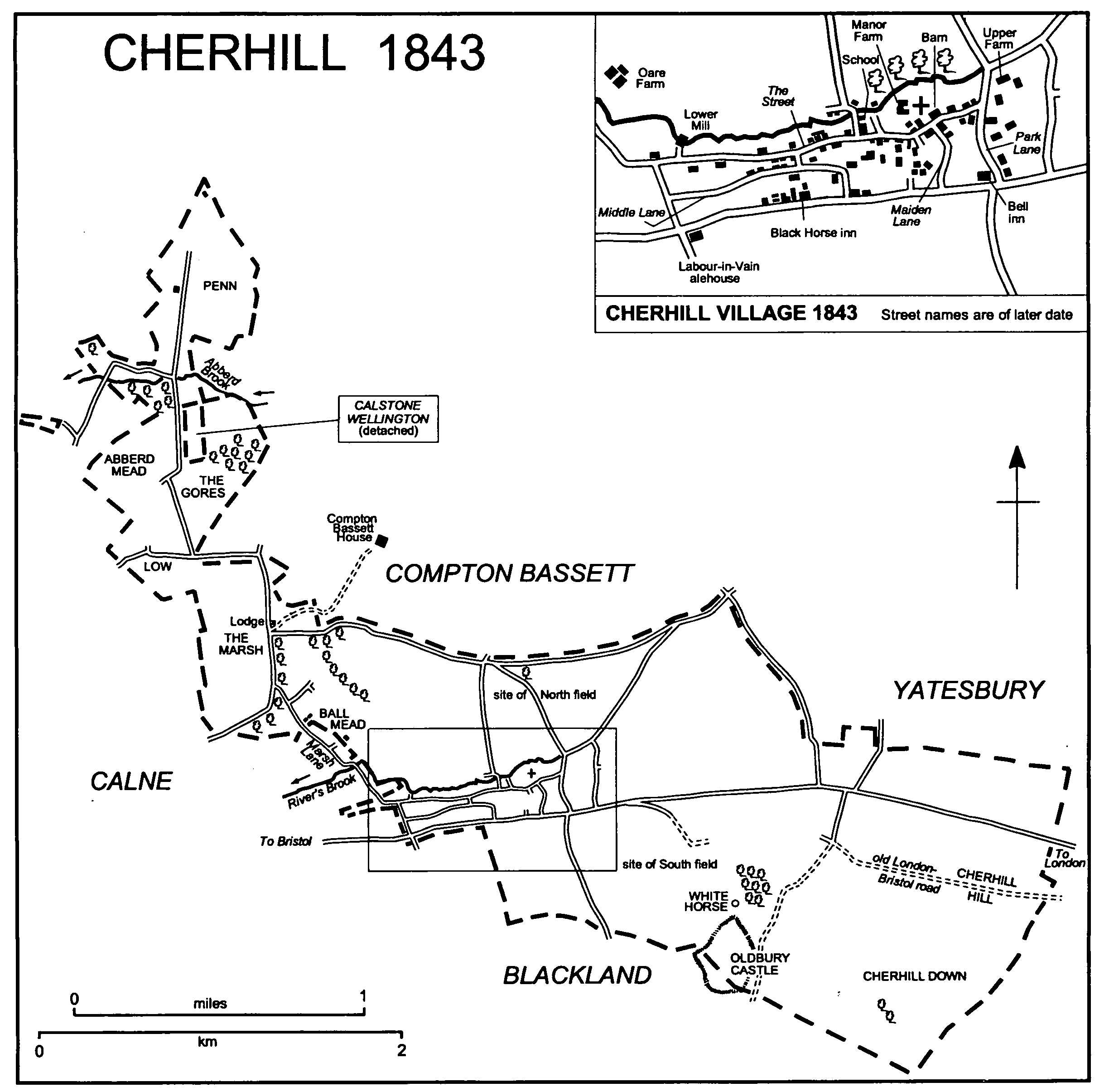
Cherhill 1843
There were apparently many small farmsteads in the village in the 13th and 14th centuries, perhaps c. 25 in 1265, (fn. 45) and c. 18 in 1728. In 1728, and presumably earlier, seven stood in a loose group south, east, and west of the church, and three stood on the east side of Park Lane. West of the group six stood along both sides of the village street, and there were two on the north side of the London road. Two mills stood on River's brook, which formed the village's north limit. (fn. 46)
Besides the Manor House, in 1999 Tudor Cottage in Park Lane was apparently the oldest house in the village. It was built in the 15th century as a timber-framed hall with, in line to the west, a storeyed chamber end. The east wall of the hall incorporated a cruck truss, and the roof incorporated side purlins, one tier of wind braces, and a chamfered ridge piece. In the late 16th century or early 17th the hall was floored, a large chimney stack was built near its west end, the chamber end was altered and given wavy braces and an oriel window, and a twostoreyed parlour bay was added on the west. (fn. 47)
In 1999 several small houses of the late 17th century or early 18th stood nearby in and off the Street and in Maiden Lane and Middle Lane. They are typically of chalk and thatch, of one storey and a half, and on a lobby-entrance plan. At the north-east end of the village Upper Farm was built c. 1800 on a site from which a farmstead had been removed by 1728. (fn. 48) The farmhouse of Upper Farm incorporates a classical brick façade and a mansard roof; when the stables were converted to a dwelling house in the early 1990s a beam inscribed GN 1800 was exposed. (fn. 49) The east part of the village was designated a conservation area in 1993; in 1998 the conservation area was extended westwards. (fn. 50)
The two farmsteads beside the London road had apparently been converted to inns called the Bell and the Black Horse by 1745. (fn. 51) The house occupied as the Bell, at the junction with Park Lane, was evidently rebuilt shortly before 1750 and survived in 1999. It remained an inn until the 1870s, when farm buildings were erected behind it and it became a farmhouse. (fn. 52) West of the Bell the house occupied as the Black Horse may have been rebuilt, perhaps on a new site, between 1765 and 1768, (fn. 53) and, west of the Black Horse, Lower Farm was built about then. Both the inn, which remained open in 1999, and the farmhouse are three-bayed, two-storeyed, buildings of brick with plain stone-mullioned windows. Two other brick houses beside the main road are dated 1810 and 1819. Three malthouses were among the buildings beside the road in 1843. (fn. 54) The Labour-in-Vain alehouse in Calne parish stood on the south side of the road. (fn. 55)
In the west part of the village a lane, between and parallel to the village street and the London road and later called Middle Lane, was in use in 1728. (fn. 56) A thatched cottage, apparently of the late 17th century or early 18th, survives in it. Further west, Oare Farm, of stone with brick dressings, was built off Marsh Lane between 1820 and 1843. (fn. 57) In the 19th century a school and several cottages were built in and off the Street, and two pairs of estate cottages were built in Middle Lane. A rectory house was built beside the main road. (fn. 58) In 1900 there were 62 houses in Cherhill, including 5 in Marsh Lane. (fn. 59)
In the 20th century many new houses were built in the village, most in the west part. At the west end of the Street four council houses were built between 1922 and 1934, on land transferred from Calne Without parish in 1934 six council houses were built in 1939 beside the main road, (fn. 60) and on adjoining sites at the west end of the Street and of Middle Lane 14 council houses were built in 1952-3. (fn. 61) On other land transferred from Calne Without parish in 1934 an estate of 11 bungalows was built in 1967-8. (fn. 62) Off the east end of Middle Lane eight council bungalows and four council houses were built in 1977. (fn. 63) Individual private houses were built in the Street and Middle Lane, and in 1999 houses were being built on the site of Bell Farm. A wooden building used at Yatesbury airfield in the First World War was re-erected in the Street in 1920 as a memorial hall. (fn. 64) It was replaced by a brick building which was in use as a community centre in 1999. A new school was built at the west end of Middle Lane in 1961. (fn. 65) Beside the main road the White Horse café was opened in 1936, the White Horse garage in 1939, and a petrol station in 1942. (fn. 66) In 1999 the White Horse café was a private house; the White Horse garage was unoccupied.
Outside the village a lodge for Compton Bassett House in Compton Bassett was built in Marsh Lane in 1830, (fn. 67) and farm buildings were erected beside the parish boundary north of Cherhill village in 1953 and later. (fn. 68) Yatesbury airfield, in use in the First World War and again from 1936, included land in Cherhill north-east of the village. From c. 1938 R.A.F. Yatesbury included a large hutted camp on the north side of the London road, and most of its buildings stood in the east part of Cherhill parish. (fn. 69) R.A.F. Yatesbury was closed in 1964, by 1969 the buildings of the camp had been removed, and between 1970 and 1972 Wiltshire county council restored the site of the camp to farmland. (fn. 70) R.A.F. Compton Bassett, open from 1940 to 1964, (fn. 71) was built as a hutted camp west of Marsh Lane on c. 120 a. of Cherhill and on adjoining land in Calne parish. It was used for radar training and had no airfield; married quarters were built in Calne parish. Like those of R.A.F. Yatesbury the huts were removed between 1964 and 1969. In 1970 the county council bought 67 a. of the land in Cherhill and by 1972 had restored it to farmland. (fn. 72)
MANOR AND OTHER ESTATES
Before the Conquest and in 1086 Cherhill was probably part of the king's large estate called Calne. (fn. 73) In 1130 John FitzGilbert, the king's marshal, owed £22 13s. 4d. to the king for land which he had inherited from his father, Gilbert the marshal. The land was probably that in Wiltshire then held by John (fn. 74) and was possibly CHERHILL manor, which John is known to have held of the king for a rent of £22 from 1156 or earlier. (fn. 75) For reasons which are not clear Cherhill manor passed on John's death in 1165 to Robert FitzPeter. (fn. 76) On Robert's death c. 1185 it passed to his brother Geoffrey FitzPeter (from 1199 earl of Essex), (fn. 77) and in 1186-7 the king confirmed Geoffrey's tenure of the manor, which was to be held as 1 knight's fee. (fn. 78) On Geoffrey's death in 1213 the manor passed to his son Geoffrey de Mandeville (d. 1216), who succeeded him as earl of Essex; (fn. 79) a grant of the manor by the elder Geoffrey to his son William de Mandeville in 1213 (fn. 80) was apparently void. The younger Geoffrey's estates were confiscated for his opposition to King John, (fn. 81) who in 1215 granted Cherhill manor to Hugh de Neville. (fn. 82) The manor was apparently among Geoffrey's possessions restored in 1217 to William, who had succeeded him as earl of Essex. (fn. 83) On William's death in 1227 his estates were divided between his sister Maud, countess of Hereford and suo jure countess of Essex, then wife of Roger of Dauntsey, and his half-brother John FitzGeoffrey. (fn. 84) Cherhill manor was apparently divided between them, (fn. 85) and between 1233 and 1236 Maud quitclaimed her share to John (fn. 86) (d. 1258). From John the manor passed to his son John FitzJohn who, except between 1265 and 1268 when he was deprived of his lands for opposition to Henry III, (fn. 87) held it until his death in 1275. John FitzJohn's heir was his brother Richard FitzJohn, from 1290 Lord FitzJohn (d. 1297). (fn. 88) After Richard's death his lands were partitioned and Cherhill was allotted to his sister Maud (d. 1301), the wife of William de Beauchamp, earl of Warwick (d. 1298). (fn. 89) From Maud the manor descended to her son Guy de Beauchamp, earl of Warwick (d. 1315), whose son and heir Thomas, earl of Warwick, was a minor. (fn. 90) Guy's relict Alice, from 1316 or 1317 the wife of William la Zouche (from 1323 Lord Zouche), held it until her death in 1325, (fn. 91) and Thomas entered on his lands in 1329. (fn. 92) From Thomas (d. 1369) the manor passed to his son Thomas, earl of Warwick. (fn. 93) In 1397 Thomas forfeited his lands for opposition to Richard II, and Cherhill manor was then granted to John Beaufort, marquess of Dorset. (fn. 94) The manor was restored to Thomas in 1399, and at his death in 1401 it passed to his son Richard de Beauchamp, earl of Warwick (d. 1439). (fn. 95) From Richard it passed to his son Henry, earl of Warwick (fn. 96) (cr. duke of Warwick 1445, d. 1446), (fn. 97) whose relict Cecily (d. 1450), the wife of John Tiptoft, earl of Worcester, held it as dower. (fn. 98) On Cecily's death the manor reverted to her sister-in-law Anne de Beauchamp, suo jure countess of Warwick (d. 1492), the wife of Richard Neville, earl of Salisbury (cr. earl of Warwick 1450, d. 1471, 'the kingmaker'). With Richard's other lands it was forfeited in 1459 and restored in 1460. (fn. 99) In 1474, as if Anne were already dead, Cherhill manor was transferred by parliament to the daughters of her and Richard, and in a partition it was allotted to their daughter Isabel (d. 1476), the wife of George Plantagenet, duke of Clarence (d. 1478). Isabel's heir was her son Edward Plantagenet, earl of Warwick (attainted and executed in 1499), a minor imprisoned from 1485, and from 1478 the manor was held by the Crown. (fn. 100) In 1487 parliament restored it to Anne, countess of Warwick, and she gave it to the king. (fn. 101)
The Crown held Cherhill manor from 1487 to 1628, when it granted all of it except a mill to the City of London at fee farm. (fn. 102) In 1630 the City sold the demesne lands of the manor, later Manor farm, to Henry Grubbe to the use of his son John. The estate was subject to a long lease held by Henry's brother Thomas and sister Susan. (fn. 103) The lease was apparently assigned to, or inherited by, John, who sold the estate to Samuel Ashe in 1692. (fn. 104) On Ashe's death in 1704 the estate passed to his son Joseph (d. 1725), whose son Joseph sold it to Peter Warren in 1734. (fn. 105) In 1767 Warren sold it to John Walker, (fn. 106) from 1777 John Walker Heneage, the owner of Compton Bassett House, and until 1918 Manor farm descended in the Walker Heneage family as part of the Compton Bassett estate. (fn. 107)
In 1631 the City of London sold the rest of Cherhill manor, subject to a long lease held by men who were probably trustees of the Grubbe family, to John Grubbe (fn. 108) (d. 1649). The estate descended to John's son Thomas (d. 1669) and to Thomas's son Walter Grubbe, on whose death in 1715 it passed to his unmarried sisters Thomasine (d. 1723) and Margaret (will proved 1756). (fn. 109) By 1720 the estate had passed, probably by purchase, to Walter's brother William (d. by 1730), whose relict Phoebe (will proved 1753) held it for life. On Phoebe's death it passed to Walter's grandnephew William Hunt Grubbe (fn. 110) (will proved 1753), and it descended in the direct line to Thomas Hunt Grubbe (d. 1772) and William Hunt Grubbe (d. by 1820). (fn. 111) In 1824 that William's trustees sold the estate to George Walker Heneage (fn. 112) and, like Manor farm, it descended as part of the Compton Bassett estate until 1929. (fn. 113) In 1929 or 1930 E. G. Harding sold a large part of it to A. H. Bond and T. J. Wilson, who sold that part in portions soon afterwards. (fn. 114)
The land of Manor farm north of Cherhill village, but not the Manor House and the buildings adjacent to it, were bought with Compton Bassett House as part of Home farm, Compton Bassett, by Guy Benson from Harding in 1929 or 1930. (fn. 115) In 1948 Benson sold the farm to D. W. Pickford (d. 1987). The land in Cherhill, including the Gores, and part of Home farm's land in Compton Bassett, descended to Pickford's son Mr. J. D. Pickford who, with his wife and his son, Mr. R. Pickford, in 2000 owned c. 1,020 a. in Cherhill, Compton Bassett, and Yatesbury as Upper farm; all the land in Cherhill, c. 650 a., lay north of the London road. (fn. 116) Of the land east of the village and north of the road 145 a. was sold in 1935 by F. C. Carr to the Bristol Aeroplane Company partly for Yatesbury airfield, (fn. 117) and in 1939 Mrs. E. M. Carr sold 51 a., and the owners of Nolands farm, Compton Bassett, sold 33 a., to the state for the camp of R.A.F. Yatesbury. The airfield, including c. 50 a. of it in Cherhill, and c. 50 a. more beside the London road, were bought by D. W. Pickford from the Bristol Flying Club in 1959. The land of the camp, including the 51 a., the 33 a., and land in Yatesbury, was bought from the state by Wiltshire county council in 1970 and sold by the council in 1972, when Pickford bought the land in Cherhill. In 1982 the Pickfords also bought the remaining 95 a. sold to the Bristol Aeroplane Company in 1935 from Mr. R. T. Candy. (fn. 118) In 1929 c. 70 a. in the parish's tongue was bought by E. G. Harding as part of Freeth farm, Compton Bassett. (fn. 119) The land remained part of the farm and in 1995 belonged to Mr. R. T. Henly and members of his family. (fn. 120)
From c. 1930 J. H. Blackford (d. 1948), the author of The Manor and Village of Cherhill, accumulated an estate in Cherhill, and c. 1940 owned much of the land south of the London road. (fn. 121) In 1960 his son D. G. Blackford sold the land south of the road as Bell farm to R. H. Rudler. (fn. 122) The farm was sold in portions in 1979, when 138 a., including the scarp southeast of the village and the part of Oldbury castle lying in Cherhill parish, was bought by the National Trust. The trust still owned that land in 1999, (fn. 123) when the land between the London road and the scarp there belonged to Mr. J. B. Ainslie. (fn. 124) In 1930, besides land north of the London road, c. 360 a. south of the road was bought as part of Nolands farm by Beatrice, Emily, and Mabel Tilley. The land south of the road descended as part of the farm, (fn. 125) and in 1989 Mrs. S. M. Rothschild sold c. 250 a. of it in portions. The largest part, c. 150 a., was bought by Mr. G. Wilkins and remained part of Nolands farm in 1999. (fn. 126) In 1992 Mrs. Rothschild, then Lady Rothschild, gave part of Cherhill down, 110 a. in the south-west corner of the parish, to the government in place of tax, and that land was transferred to the National Trust, the owner in 1999. (fn. 127)
Tithes from Cherhill were presumably among the possessions of Calne church when it was given to Salisbury cathedral in 1091 and when, no later than 1116, its estate was used to endow a prebend in the cathedral. Between 1220 and 1227 the prebend was annexed to the treasurership of the cathedral and, as part of his PREBENDAL estate, the treasurer held the tithes of Cherhill until 1841, when they passed by Act to the Ecclesiastical Commissioners. (fn. 128) In 1844, when in Cherhill the estate included Oare Farm and 14 a., the tithes there were valued at £340; in 1845 the tithes were commuted. (fn. 129) The land and buildings were bought in 1857 by Henry Petty-Fitzmaurice, marquess of Lansdowne, and descended as part of the Bowood estate until they were sold in 1919. (fn. 130) Their later descent has not been traced.
The vicar of Calne was entitled to small tithes arising from Cherhill, (fn. 131) and from 1734 he also held other tithes and 1 yardland held until then by the curate serving Cherhill church. (fn. 132) When the open fields of Cherhill and the grassland used in common by the men of Cherhill, Calne, and other parishes were inclosed in 1821 he was allotted 29 a. in Cherhill for the yardland and feeding rights in respect of it, and 15 a. in Cherhill and 6 a. in Calne to replace tithes. (fn. 133) The vicar retained tithes only of homesteads which, valued at £1 5s., were commuted in 1845. In 1843 he had 49 a. in Cherhill. (fn. 134) That land was sold in portions in 1919, 1926, and 1952. (fn. 135)
ECONOMIC HISTORY
Cherhill had c. 840 a. of open-field arable which lay north, south, and east of the village. It was worked as two fields, North and South. (fn. 136) On the chalk in the south-east corner of the parish Cherhill down, c. 445 a., was rough pasture, presumably usually for sheep. (fn. 137) On the clay and sandy soils north-west of the village there were extensive lowland meadows and pastures where the men of the village had the right to take hay and feed their animals in common. (fn. 138)
In 1265 the demesne of Cherhill manor was said to include 228 a. of arable in the open fields, 18 a. of additional arable, 23 a. of meadow, and a several pasture called the Gore estimated at 20 a. The other land of the manor was shared among 5 freeholders, who held 5½ yardlands, 13 yardlanders, 7 half-yardlanders, and 12 cotsetlanders. All but the freeholders owed labour service on the demesne; the holdings of the cotsetlanders were later estimated at a third of 1 yardland. By 1265 Cherhill down had apparently been divided between pasture for sheep kept on the demesne and pasture for the tenants' cattle. On the demesne downland there was said to be enough pasture for 500 sheep, and 18 a. of the otherwise tenantry downland was ploughed as part of the demesne. (fn. 139) In 1397 the demesne arable was estimated at 200 a., and the demesne included the right to take hay from 29 a. of apparently commonable meadow land including Abberd mead. The downland pasture used as part of the demesne was said to be sufficient for 600 sheep. The demesne, which was still managed directly, had on it a large barn, a stable incorporating a bailiff's room, a granary, and a cattle house, and was stocked with 17 horses and oxen, a bull and 3 cows, and 815 sheep and lambs. The freeholds apparently remained small, and of c. 28 customary tenants only one, who held 1½ yardland, is known to have held more than 1 yardland. (fn. 140) The demesne had been leased by the late 15th century. (fn. 141)
In the late 16th century Cherhill's only land held in severalty may have been the home closes in and near the village, the Gore, and as much of the down as was reserved for the demesne sheep. North-west of the village the Marsh was a common pasture for cattle and horses, and Ball mead was a commonable meadow of 6 a. or more. North and South fields were then apparently of roughly equal size. (fn. 142) Also north-west of the village Penn was an extensive common pasture probably used in common by the men of Cherhill, Calne, and Compton Bassett; Cherhill's part remained commonable when, apparently no later than 1628, it was divided from the rest. In the early 17th century Low was used by the men of Cherhill and Calstone to feed horses, cattle, and sheep in common, and Abberd mead was still used in common by men of Cherhill and elsewhere. (fn. 143) In 1599 the demesne farm of Cherhill manor included a nominal 80 a. in each of North and South fields, c. 15 a. in Abberd mead, and the first cut of 7 a. of meadow at Clevancy, in Hilmarton. At Cherhill 25 copyholds each included land in both open fields, a plot in Abberd mead, and what was probably a small farmstead. The largest had nominally 45 a. of arable and 3 a. of meadow, the smallest 8 a. and ½ a.; the average was 24 a. of arable and 2 a. of meadow. There were eight freeholds, one of which is known to have been of 1 yardland and none of which is likely to have been much larger. (fn. 144)
The Marsh, c. 145 a., was apparently inclosed, divided, and allotted between 1599 and 1616. It lay as closes in 1651, as c. 65 closes in 1728, and as 50-60 fields of 1-6 a. in the early 19th century. Marsh Lane, a wide lane in which the feeding was in common, was left across it for cattle to be driven to and from Low, Abberd mead, and Penn. (fn. 145) Possibly about the same time and certainly by 1728 the whole of Cherhill down was made a several part of the demesne farm, and later evidence suggests that, when the Marsh was inclosed, rights over it held in respect of the farm were exchanged for exclusive use of the down. Also by 1728 Low had been divided, 57 a. remaining commonable to the men of Cherhill and the rest to the men of Calstone. (fn. 146) Abberd mead, 263 a. in 1728, was shared by the men of Cherhill and men of Calne, Calstone, and, to a small extent, Compton Bassett. It lay divided by superficial marks, the holder of each plot took the hay from his own plot, and the whole meadow was grazed in common after the hay was carried from it. In the early 19th century cattle were fed from the time when the hay was carried until Michaelmas, sheep from Michaelmas to Christmas; the men of Cherhill had the right to feed 665 sheep on the meadow. (fn. 147) Penn and Low were then grazed by cattle in summer and autumn and by sheep in winter. (fn. 148)
In 1728 the demesne, later called Manor farm, was of 698 a. and included 84 a. in North field, 94 a. in South field, 28 a. of pasture in three closes called the Gores, Cherhill down, 1 a. in Ball mead, 18 a. in Abberd mead, and feeding rights on Ball mead, Abberd mead, and the other lowland pastures. Its land in the open fields lay in parcels averaging 9 a. Of the other farms based in the village one, with a farmstead in Park Lane, was of 163 a. and included 120 a. lying as c. 110 strips in the open fields, 28 a. in closes mainly in the Marsh, 15 a. in Abberd mead, and feeding rights. Of c. 29 other holdings of land in the parish, c. 600 a. in all, only c. 17 included a farmstead in the village. Several farms are known to have had 50-100 a. and the average size of the farms may have been c. 35 a. All the farms had land in the open fields lying as strips of c. 1 a., small areas of inclosed meadow or pasture, mostly in the Marsh and as home closes, and feeding rights for cattle and sheep on the lowland pastures. (fn. 149)
Under an Act of 1820 the open fields of Cherhill and the meadows and pastures called Penn, Abberd mead, Low, and Marsh Lane were inclosed in 1821. The open fields, c. 840 a., were divided into c. 70 closes, of which the largest, allotted for Manor farm, was of 103 a. and c. 50 were of less than 10 a. The men of Cherhill received 17 allotments in Penn totalling 91 a., 41 in Abberd mead totalling 103 a., 18 in Low totalling 62 a., and 33 in Marsh Lane totalling 22 a. Allotments of 5 a. or less in Low and Marsh Lane were bounded by stones and, after haymaking, remained commonable for 65 cattle in summer and autumn and for 251 sheep in winter. Those allotments, which might be inclosed if a majority of the tenants so wished, (fn. 150) remained commonable in the later 19th century. (fn. 151) The allotments of the open fields and commonable grasslands of Cherhill were so numerous, and consequently the closes so small, because, apart from Manor farm, most of Cherhill manor was held in many small copyholds and leaseholds for life in respect of all of which allotments were made. Many of the copyholds and leaseholds were presumably sublet and held in groups. Between the Marsh and the village Ball mead, 22 a., and 17 a. of pasture called the Oar were also inclosed in 1821. (fn. 152)
In 1843 the parish included c. 940 a. of arable, c. 335 a. of meadows and lowland pasture, and 445 a. of downland, nearly all of which was pasture. Manor farm, 498 a., included 230 a. of arable, mostly former open-field land, and 212 a. of downland. The largest of the other farms were one including the farmstead later called Upper Farm and c. 225 a. in Cherhill parish, one including Oare Farm and c. 185 a. in the parish, and one with c. 193 a. in the parish. There were apparently several farms of less than 100 a. based in the village. The eastern half of the downland, and 6 a. of arable, were part of Nolands farm based in Compton Bassett parish. (fn. 153)
By the early 19th century Upper Farm and Oare Farm had been built at the east and west ends of the village respectively, and between 1843 and 1885 other farmsteads away from the centre of the village came into use. Beside the London road Bell Farm, the farmhouse of which was the former Bell inn, was built at the east end of the village, and Lower Farm, where there was a malthouse in 1843, was a farmstead at the west end in 1885. North-east of the village Hill Barn was built on former open-field land in Upper farm, and south-east of the village buildings were erected on the downs in Nolands farm. (fn. 154) In the early 20th century the tenant of Manor farm held 464 a., Bell farm had 281 a., Upper farm 220 a., and Lower farm 127 a., and there were farms of 111 a., 81 a., and 35 a. based in the village; 72 a., probably most of Penn, was worked from Compton Bassett parish as part of Freeth farm, and 224 a., the eastern part of the downs, was still part of Nolands farm. (fn. 155) Between 1918 and 1929 much of the farmland was brought in hand by the owner, but from c. 1930 was again in individual farms. (fn. 156) By the early 1930s the amount of arable in the parish had been greatly reduced, much of the former open fields then being permanent grassland, (fn. 157) and most of the parish was probably used for dairy farming. (fn. 158) In the earlier 20th century agricultural land was taken for Yatesbury airfield, for R.A.F. Yatesbury, and, west of Marsh Lane, for R.A.F. Compton Bassett; by 1972 all that land, except some west of Marsh Lane, had been restored to agriculture. (fn. 159)
The number of farms based in the parish was reduced to one in the later 20th century. About 1930 the buildings of Manor farm went out of use for agriculture and its lands were divided between Home farm, Compton Bassett, and Nolands farm. (fn. 160) From the 1950s most of the land north of the village, including the Gores but not other land in the parish's tongue, and most of that east of the village and north of the London road, was acquired by members of the Pickford family and worked as Upper farm from a new dairy north of the village and from new buildings at Upper Farm. In 2000 Upper farm was an arable and dairy farm of c. 1,020 a. including land in Compton Bassett and Yatesbury. (fn. 161) About 1930 Nolands farm had c. 475 a. in the east part of the parish; the area was later reduced. (fn. 162) In 1999 Nolands farm included c. 150 a. of arable at the east end of the parish and south of the London road, and c. 70 a. there was used as gallops for racehorses in training at stables at Beckhampton, in Avebury. Bell farm, mainly south-east of the village, was divided in 1979, from when its land was worked from outside the parish and was mainly arable. (fn. 163) In 1999 land in the tongue was used for mainly arable and beef farming as part of Freeth farm, (fn. 164) and the 248 a. of downland owned by the National Trust was used for grazing. (fn. 165)
There has never been much woodland in Cherhill. (fn. 166) A 12-a. allotment in Abberd mead was planted with trees between 1821 and 1843, and 9 a. in the Gores and 8 a. near Oldbury castle had also been planted by 1843. North of the village c. 7 a. of woodland stood on the edge of the park of Compton Bassett House, probably from the later 18th century. (fn. 167) Other small plantations were made in the 19th century. (fn. 168) All that woodland was standing in 1999 except the plantations in the Gores and Abberd mead which were removed in the later 20th century. (fn. 169)
Two mills in Cherhill were driven by River's brook. (fn. 170) One, part of Cherhill manor in 1265, (fn. 171) was probably the water mill near the church and the demesne farmstead and later called Upper mill. (fn. 172) A mill remained part of the manor until 1609. (fn. 173) The second, held freely of the Prebendal estate from the early 15th century or earlier, (fn. 174) was probably Lower mill on the stream near the west end of the village. In the 18th century Upper mill was used as a corn mill, was converted for leather dressing, became ruinous, and by 1786 had been restored as a corn mill. It was apparently in use in 1813. It had been demolished by c. 1827. (fn. 175) A misreading of a map of 1728 led to Lower mill's being called a flax mill. In the 19th century it was a corn mill until it went out of use in 1896. (fn. 176) A new mill, of three storeys, of four or more bays, and of stone rubble with brick dressings to the windows, was built apparently in the early 19th century; two of the bays were later reduced to one storey, and the mill was converted to a house.
A broadweaver lived at Cherhill in 1688. (fn. 177) In the early 19th century and the early 20th there were sand pits in Low from which sand was transported by donkey for sale within a 50-mile radius. (fn. 178) In the later 20th century Low, and from 1970 the west part of Cherhill's land formerly part of R.A.F. Compton Bassett, were used with adjoining land in Calne parish for extracting sand mechanically and replacing it with refuse. A large building for recycling refuse was erected in Cherhill parish. (fn. 179)
LOCAL GOVERNMENT
By the late 13th century the lord of Cherhill manor had begun to hold view of frankpledge twice a year in addition to the manor court. (fn. 180) In the 16th century and later very few presentments were made under leet jurisdiction. (fn. 181) In 1491-2 and 1544-5 the view and the court were held together in April and October. The combined court transacted tenurial business and heard presentments including failure to maintain boundaries, repair houses, and prevent pigs from entering common fields, and interference with watercourses. Apparently the steward granted probate of wills. (fn. 182) In the 18th and 19th centuries the main business of the court was conveyancing of copyholds and recording the death of tenants. Encroachments on the waste, stray animals, dilapidated buildings, and public nuisances, including the dangerous state of sand pits in Low, were occasionally presented. A bailiff, a constable, two haywards, and a tithingman were appointed. In the late 19th century the court met at the Black Horse; the last meeting was in 1896. (fn. 183)
The accounts of overseers of the poor survive for 1685-1728 and 1792-1819. Two overseers were in office each year; they were elected for a year and apparently served in turn, usually for six months each. A woman was in office for each of three years in the early 18th century and seems to have served in person. Expenditure on the poor increased from £12 in 1686-7 to £26 in 1693-4 but was no more than £7 in 1725-6. In the earlier part of the period 1685-1728, when there were about four paupers, nearly all the money was spent on doles; in the later part, when there were only one or two paupers, most was spent on clothing, blankets, funerals, and medical attention. In 1725-6 the parish held a house by lease, presumably the house in Marsh Lane which it held later. In 1796-7 £20 was spent, almost exclusively on regular doles. (fn. 184) In 1802-3, when the Cherhill poor rate was very high for Calne hundred and £189 was spent on poor relief, 53 adults and 42 children, nearly a third of the parish, were relieved regularly and 19 people were relieved occasionally; in addition money was spent on helping 89 non-parishioners, presumably travellers on the London-Bristol road. (fn. 185) In 1812-13 £203 was spent but only 25 adults were relieved regularly and 6 occasionally. (fn. 186) Besides paying regular doles the parish paid for coal, clothing, rent, the upbringing of orphans and bastards, apprenticing, burials, nursing, and lying-in. (fn. 187) Thereafter spending on the poor fluctuated, reaching a peak of £332 in 1833 and a low point of £55 in 1818. (fn. 188) Cherhill joined Calne poor-law union in 1835 (fn. 189) and became part of North Wiltshire district in 1974. (fn. 190)
CHURCH
Cherhill church had been built by the 12th century (fn. 191) and was dependent on Calne church as a chapel. The prebendary of Calne was obliged to provide services in it, between 1220 and 1227 the obligation passed to the treasurer of Salisbury cathedral, (fn. 192) and from the 15th century or earlier chaplains, later curates, were appointed by the treasurer. (fn. 193) In the early 15th century the inhabitants had all rights in their church except burial; (fn. 194) from the mid 16th century or earlier they also had burial rights. (fn. 195) In 1734 the curacy was united with the vicarage of Calne, which was also in the treasurer's gift. (fn. 196) It was disunited in 1842, when the living for Cherhill became a perpetual curacy. (fn. 197) In 1865, under an Act of that year, the living was declared a rectory, (fn. 198) and in 1973 the rectory was united to other benefices to form Oldbury benefice. (fn. 199) In 1879 Cherhill ecclesiastical parish was enlarged by the transfer to it of 204 a. of Calne parish. (fn. 200)
The patronage enjoyed by the treasurer of the cathedral passed to the bishop in 1841 under the Cathedrals Act, (fn. 201) the bishop had the right to nominate perpetual curates of Cherhill from 1842, and the first perpetual curate was licensed in 1844. (fn. 202) The bishop was patron of the rectory from 1865 and, in an exchange in 1882, gave the patronage to the executors of Wadham Wyndham (fn. 203) (d. 1843). The patronage passed in turn to Wyndham's nieces Ellen King-Wyndham (d. 1889) and Caroline Pleydell-Bouverie-Campbell-Wyndham (d. 1908) and to Caroline's daughter Mary CampbellWyndham-Long. Mary's executors remained patrons until 1973, (fn. 204) but no representative of her interest sat on the patronage board of Oldbury benefice. (fn. 205)
In 1405 the treasurer of the cathedral was giving 40s. a year to the chaplain and allowing him the use of a house and 24 a. in Cherhill. (fn. 206) In 1649-50 the curate received £16 from the lessee of the Prebendal estate, held 1 yardland of the Prebendal estate in Cherhill, and took some small tithes. (fn. 207) In 1733 the value of the curacy was said to be £44. (fn. 208) From 1734, when the curacy was united with the vicarage of Calne, the land and tithes were held by the vicar, who apparently retained them when the livings were separated in 1842. (fn. 209) In 1844 the Ecclesiastical Commissioners, who held the great tithes of Cherhill as successors to the treasurer, raised the perpetual curate's income to £80, (fn. 210) and in 1863 raised it to £119. (fn. 211) A house for the perpetual curate was built in 1844-5. (fn. 212) It is of ashlar under a low-pitched slated roof, on the ridge of which the chimney is disguised as a bellcot. The house was enlarged in 1864-5 (fn. 213) and again in 1872, when a large projecting bay incorporating a porch was built on the south front. (fn. 214)
In the 1560s services at Cherhill were not held at times convenient to the parishioners because the curate also served Compton Bassett; quarterly sermons were not preached and the church lacked a copy of Erasmus's Paraphrases. (fn. 215) In the earlier 17th century the churchwardens complained that services were irregular, that the curate had no licence to preach, and that the books in the church were defective, (fn. 216) and in the 1760s there was apparently only one service at Cherhill each Sunday. (fn. 217) In the mid 19th century there were two services each Sunday, and on Census Sunday in 1851 they were attended by 72 in the morning and 125 in the afternoon. (fn. 218) Two services, each with a sermon, were held every Sunday in 1864, and there were additional services at the great festivals and in Advent and Lent. There were 38 communicants; c. 20 attended communion services, which were held c. 12 times a year. (fn. 219) From 1951 to 1972 Cherhill was served in plurality with Yatesbury, and as part of Oldbury benefice was served by a team ministry 1973-7 and a group ministry from 1978. (fn. 220)
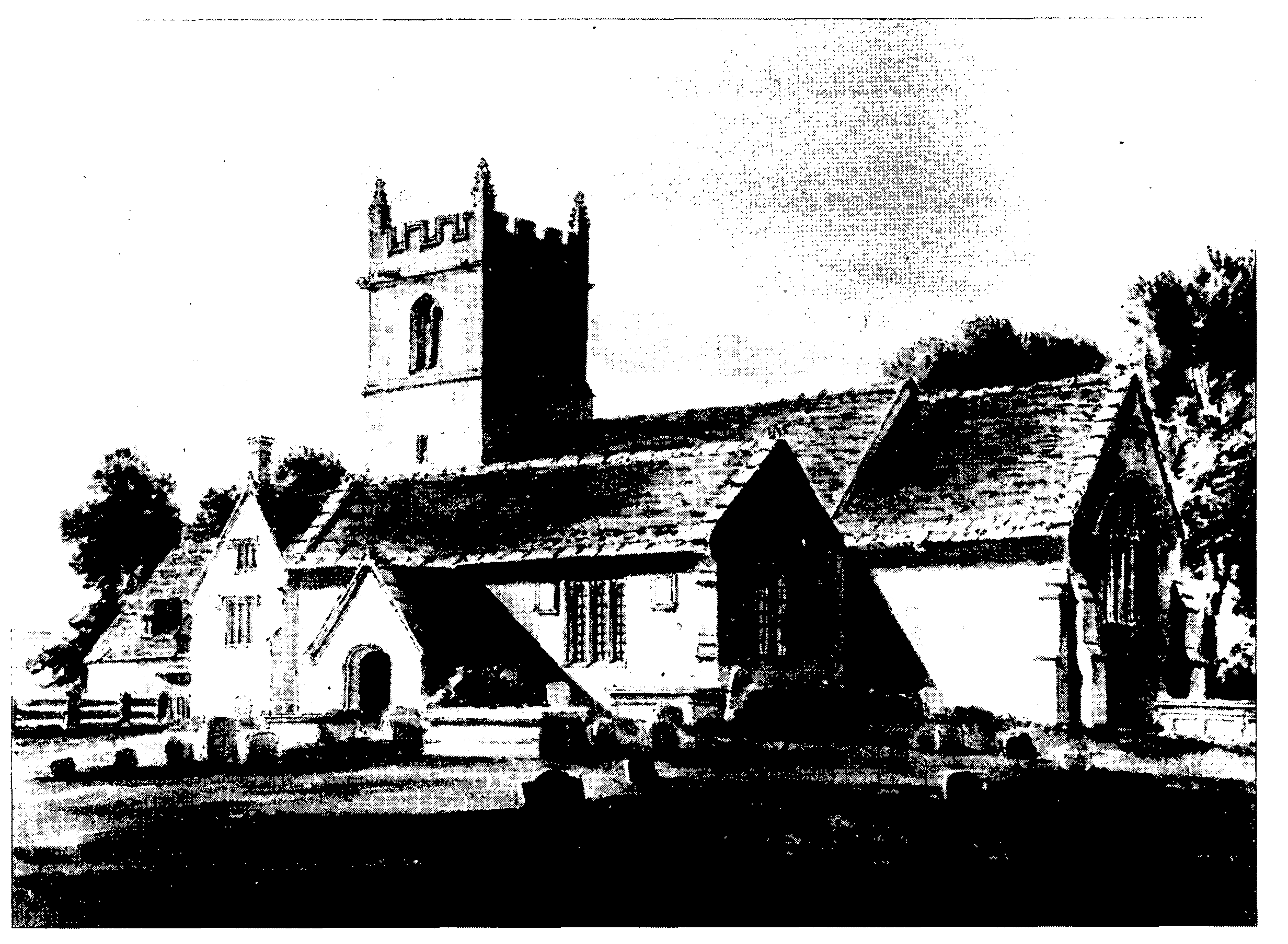
St. James's church from the south-east in 1806
The church of ST. JAMES, so called in 1405, (fn. 221) is built of stone rubble and is partly rendered. It consists of a chancel and nave with south aisle, south porch, west tower, and north vestry. The chancel and nave was probably built in the 12th century, the date of a blocked round-headed doorway in the north wall of the nave. The aisle, with an arcade of three fourcentred arches and octagonal piers, and the tower, of three stages, were built in the late 15th or early 16th century. The east window was inserted about then; in the 17th or early 18th century the west window was altered, three rectangular single-mullioned windows were inserted in the north wall of the nave, and a new, ceiled, nave roof was constructed. The roof of the aisle incorporates lengths of moulded and chamfered domestic timber. A Gothick west gallery was built in 1840. (fn. 222) The church was restored in 1863 to designs by S. B. Gabriel. The vestry was built, a mock hammerbeam roof for the chancel was constructed, and the south wall of the porch, in which there was a roundheaded doorway in 1806, was rebuilt with a doorway in Perpendicular style. (fn. 223)
In 1553 plate weighing 3 oz. was confiscated, and a chalice of 9½ oz. was retained for the church. A chalice hallmarked for 1631 and a paten hallmarked for 1717 were acquired by the church, perhaps soon after they were made, and were still held in 1891; a new set of plate, consisting of a chalice, two patens, a flagon, and an almsdish, was given in 1863. (fn. 224) In 1999 the church held the paten hallmarked for 1717, a chalice hallmarked for 1749, and, with the exception of a paten, the plate given in 1863. (fn. 225)
The church had three bells in 1553, one of which, cast at Bristol c. 1450, hung in the church in 1999. The treble was replaced in 1619 by a bell cast by Richard or Roger Purdue, the tenor in 1641 by a bell cast at Warminster by John Lott and recast at Whitechapel in 1987. Those two bells and a sanctus bell also hung in the church in 1999. (fn. 226)
Registers of baptisms survive from 1690, of marriages from 1709, and of burials from 1708. (fn. 227)
NONCONFORMITY
A Roman Catholic chapel which opened at R.A.F. Compton Bassett in 1940 and was served from an R.A.F. station at Melksham, and a mass centre opened at R.A.F. Yatesbury in the same year, (fn. 228) may have stood in Cherhill parish.
Quakers lived at Cherhill in 1666 and 1783. (fn. 229) In 1700 a house was registered for worship by nonconformists. (fn. 230) Independent Methodists certified a meeting house in 1823, and in 1830 and 1835 Primitive Methodists certified premises for worship. (fn. 231) The building certified as a chapel in 1835 may have been part of a private house. (fn. 232) A meeting house registered in 1843 was probably also for Primitive Methodists, and a chapel said to have been built in 1846 for Primitive Methodists may have been part of, or attached to, a private house. One service, attended by 110, was held on Census Sunday in 1851 in what was called the chapel. (fn. 233) In 1864 there were two small rooms used for meetings of Primitive Methodists, and c. 10 Baptists lived in the parish. (fn. 234) Meetings of Primitive Methodists probably continued in the parish until c. 1900. (fn. 235)
EDUCATION
There was no school at Cherhill in 1818. (fn. 236) In 1833 there were two day schools, (fn. 237) and in 1843 a school stood near the site of Upper mill. (fn. 238) A new school was built beside the Street in 1846 or 1847, (fn. 239) and in 1859, when it was attended by 40-50 pupils, it was the only school in the parish. (fn. 240) In 1864 girls left aged c. 13, boys aged c. 9, (fn. 241) and in 1871 the school was attended by 35 girls and 11 boys. (fn. 242) Average attendance rose from 36 in 1903 to 56 in 1909-10, and had fallen to 29 by 1935-6. (fn. 243) Attendance increased after R.A.F. Compton Bassett and R.A.F. Yatesbury were opened; a room was leased as an extra classroom in 1951, and an annexe was opened at R.A.F. Compton Bassett in 1956. (fn. 244) A new school built in Middle Lane was opened in 1961. (fn. 245) In 1998 it had 174 pupils aged between 4 and 11. (fn. 246)
CHARITY FOR THE POOR
None known.