A History of the County of Sussex: Volume 6 Part 2, Bramber Rape (North-Western Part) Including Horsham. Originally published by Victoria County History, London, 1986.
This free content was digitised by double rekeying. All rights reserved.
'Bramber Rape (North-western Part) ', in A History of the County of Sussex: Volume 6 Part 2, Bramber Rape (North-Western Part) Including Horsham, (London, 1986) pp. 1-4. British History Online https://www.british-history.ac.uk/vch/sussex/vol6/pt2/pp1-4 [accessed 24 April 2024]
BRAMBER RAPE (North-western Part)
THE NORTH-WESTERN part of Bramber rape lies across the varied geological strata of the Weald, from the Chalk of the South Downs in Sullington to the wide band of Weald clay around Horsham; there are ridges of Greensand immediately north of the Chalk, and outcrops of older sandstones further north, chiefly in Horsham parish. Apart from the downland scarp in the south end of Sullington, the highest land is on the Upper Greensand ridges around Thakeham and Warminghurst and in the low hills that surround Horsham on all sides except the west. The area is drained chiefly by the western Adur and the Arun and their tributaries; the Arun flows through Horsham town. Much of the Weald clay country was heavily wooded in the Middle Ages, and timber has been an important crop since that time. It was also the chief building material, especially in the clay parishes, and many medieval timber-framed houses, some of high quality, survive. Local sandstone also served as a building material, both for walling and for roofing.
The sandstone ridges in the south were settled relatively early. Further north settlement was later and more scattered. Much of the north in Saxon times was divided among manors in the southern part of the rape as outlying holdings used for seasonal swine pasture. Some manors had a series of such outliers strung out from south to north along drove roads: for instance Steyning had Ashurst, Withyham in Shipley, and Shortsfield in Horsham, and Washington had Crockhurst and Denne in Horsham, and Horsham itself. By the end of the 11th century, however, some Wealden manors, for example Shipley and possibly Hawksbourne in Horsham, were separate, and there were churches at Shipley, apparently at West Grinstead, and possibly at Itchingfield. As other outlying holdings became more permanent settlements, churches were built to serve them, at Warnham and Horsham by c. 1200; the sites which they occupied were often on drove roads, and at points accessible to groups of scattered settlements. Wealden parishes were later large, Horsham, the largest in the area, having nearly 11,000 a. (4,452 ha.). Two former outliers of Sullington manor near Broadbridge Heath remained detached parts of Sullington parish until 1878.
At Thakeham a small village may have existed by the 12th century, but nucleated settlements further north grew up only later, often around an existing church. The names of modern villages often first occur as describing a pasture place (e.g. Horsham) or a unit of local government (e.g. Warnham and West Grinstead) rather than settlements. Evidence for nucleation is sometimes architectural; at Roffey in Horsham, on the other hand, a hamlet certainly existed by 1579 when Roffey Street was mentioned. Shipley seems not to have had the character of a village until the 18th century or even later, while at West Grinstead only three houses are ever known to have existed near the church, one being the rectory; the manor house lay elsewhere.
In later centuries some rural settlements contracted, for instance Warminghurst and Buncton in Ashington. By the 17th century several new settlements were beginning to grow up by 'ribbon development' along roads, or around the edges of commons. Some, like Bines Green in Ashurst or Coolham in Shipley, remained small, but the modern Ashington village, Barns Green in Itchingfield, and Partridge Green in West Grinstead all grew rapidly in the 19th and 20th centuries, Ashington after the inclosure of its common in 1816, and Partridge Green after the opening of the Horsham-Shoreham railway in 1861.
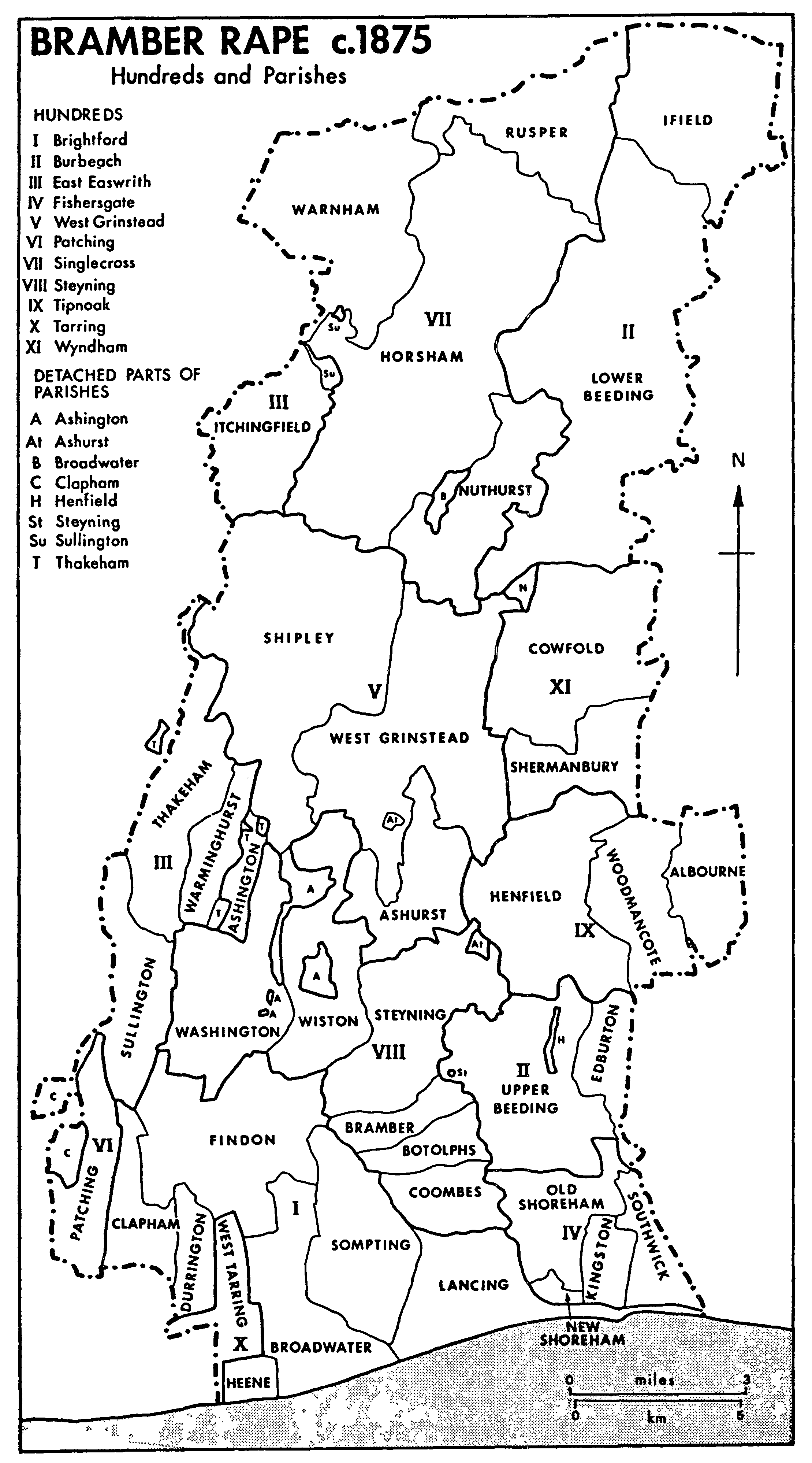
Bramber Rape c. 1875 Hundreds and Parishes
Horsham is the only town in the area. It was a borough by 1235, and developed later as a Wealden centre and one of the chief towns in the county; besides its economic role it was the seat of the county gaol by 1540, and one place for holding assizes and quarter sessions. From 1889 to 1916 it was joint county town (with Chichester) of West Sussex. After 1947, however, it came to be eclipsed in many ways by the growth of Crawley new town to the north-east.
The period from 1850 onwards saw a very large influx of new residents of the upper middle class throughout the area, attracted by good rail communication with London, fine scenery in which many houses enjoyed wide views over the Weald, and the easy availability of field sports. Among the better known newcomers were Sir Henry Harben of Warnham, president of the Prudential Assurance Co., and Hilaire Belloc of King's Land in Shipley. Some houses built or rebuilt in the later 19th century and early 20th for such people were large, and they usually had parkland; notable examples included Warnham Court, the seat of the Lucas family, and Little Thakeham, designed by Sir Edwin Lutyens. There was much immigration by less wealthy people too, especially in the 20th century. Horsham more than trebled in size between 1891 and 1971, but there was also extensive building, especially after the Second World War, in some rural parishes: at Ashington, Barns Green, and Partridge Green, and in Sullington and Thakeham on the outskirts of Storrington. In 1985 many residents worked elsewhere, especially in London, in Crawley, or at Gatwick airport.
Small open fields are recorded in the Middle Ages and later in the sandstone country of the south at Ashington, Clayton (in Sullington and Washington), Warminghurst, and Thakeham. In the Weald clay parishes the succession of agriculture to seasonal transhumance was not usually accompanied by the creation of such fields. References to open fields in Ashurst and West Grinstead are uncertain; in Horsham and Warnham, however, some land lay in open fields in the 14th and 15th centuries. A number of parks in the Middle Ages provided game and timber, for instance at Warminghurst, at Knepp in Shipley, or at Chesworth in Horsham. Common land was extensive in the past in Horsham parish, where Horsham common, north and east of the town, covered over 700 a.; other commons in the area were Jolesfield common in West Grinstead and Ashington common, both on the clay, and Heath common on the sandstone in Warminghurst, Thakeham, and Sullington. Most common land was inclosed during the 19th century. From c. 1850 farming in the area was influenced by the growth of London and of the coastal towns. Cattle raising, for meat and milk, came to predominate over arable in that period, and was accompanied by poultry farming and market gardening; the firm of A. G. Linfield Ltd. in Thakeham became the largest mushroom grower in Europe. Larger landholders in the area since the Middle Ages have included in the 16th and 17th centuries the Carylls in Warnham, Shipley, and West Grinstead, and in the 18th and 19th the Butlers in Warminghurst, the Shelleys in Warnham and Horsham, the Hursts in Horsham, and the Burrells in Shipley and West Grinstead. London merchants were apparently investing in real estate in Warnham, as in neighbouring parts of Surrey, by the 15th century. (fn. 1)
Non-agricultural economic activities in the past have included ironworking at Roffey in Horsham, at Warnham, and at Knepp in Shipley, and brickmaking especially at Partridge Green and in the northern and southern ends of Horsham parish. Horsham merchants had trading links with London and apparently the west country by the late Middle Ages. From the late 19th century the town's economic base widened to include engineering and various manufactures.
Most roads in the past trended from south or south-west to north or north-east, linking the manors in the south with their Wealden outliers. After the introduction of wheeled traffic, roads particularly on the clay deteriorated greatly; in the turnpike era, however, Horsham became a centre of communication, as it continued to be after the creation of the railway network in the mid 19th century. Further south, the modern east-west road across the Weald linking Billingshurst and Cowfold was not cut until the 1820s. The western branch of the river Adur was an important traffic artery both before and after its improvement in the early 19th century, until superseded by the Horsham-Shoreham railway.
The size of parishes and the remoteness of some settlements favoured the survival of Roman Catholicism and the growth of protestant nonconformity in the 17th and 18th centuries. West Wolves Farm in Ashington, Bentons Place in Shipley, and West Grinstead manor house were centres of Catholicism, while in the later 17th century Quakers were strongly represented, under the protection of William Penn, in Warminghurst, Shipley, and Thakeham, and there were both Quakers and Baptists in Horsham.