A History of the County of Somerset: Volume 7, Bruton, Horethorne and Norton Ferris Hundreds. Originally published by Victoria County History, London, 1999.
This free content was digitised by double rekeying. All rights reserved.
'Pitcombe', in A History of the County of Somerset: Volume 7, Bruton, Horethorne and Norton Ferris Hundreds, (London, 1999) pp. 50-59. British History Online https://www.british-history.ac.uk/vch/som/vol7/pp50-59 [accessed 24 April 2024]
In this section
PITCOMBE
The ancient parish of Pitcombe, originally part of the minster parish of Bruton, occupied a crescent-shaped area to the south and south-west of Bruton. (fn. 1) It included the scattered village of Pitcombe in a valley at the centre of the crescent and the hamlets of Cole to the north, Honeywick and Hadspen to the west, and Hadspen House towards the south. The parish stretched from Discove in the east 4 km. westwards to the top of the scarp above Castle Cary and from the rising ground just north of the river Brue southwards 4 km. to a shallow valley between Yarlington Sleights and Bratton hill. A tongue of the parish intrudes eastwards into Bruton and the western end of Shepton Montague parish similarly reaches into Pitcombe. In the heart of the parish is a plateau shared with Shepton Montague, which is interrupted by two steep-sided valleys, (fn. 2) that to the east, formed by the river Pitt, the site of the settlement which gives the parish its name. (fn. 3) The parish appears to have no natural boundaries (fn. 4) and part of that with Bruton was in dispute in the 19th century where fields were shared and where there was a detached area around Discove farm. (fn. 5) Further misunderstanding was created by confusion between the parish and tithing of Pitcombe and not until 1863 or later was the area of the parish agreed at 2,232 a. (fn. 6) Detached areas were transferred from and to Bruton respectively in 1883 and 1885 (fn. 7) and since then the area has been reckoned at 911 ha. (2,251 a.). (fn. 8)
The central plateau is of Inferior Oolite whose highest point is Pen Hill (150 m. (481 ft.)) on the boundary with Shepton Montague immediately north of Hadspen House and the lowest is at Cole in the Brue valley (51 m. (194 ft.)). Spurs in the west above the Hadspen valley reach 120m. (460 ft.) and in the east Cliff Hill, south of Godminster Farm, reaches 110 m. (420 ft.). The two valleys, with streams draining north-east and northwest into the Brue near Cole, are formed of Midford Sands, and bands of Fuller's Earth clay and limestone run along the eastern edge of the parish and near Hadspen House. (fn. 9)
The steep sides of the valleys dictated the road pattern and originally the roads probably ran down the Hadspen and Pitcombe valleys towards Bruton. Routes across the plateau linking Castle Cary with Sherborne and Hindon (Wilts.) and Bruton were turnpiked in the 1750s. A fourth road, directly from Bruton to Ansford and known in 1761 as the great road, ran through the Brue valley at Cole in the north of the parish and was turnpiked in 1793. That route was later diverted at its west end, abandoning Ridge Lane, now a bridleway, in favour of the present road through Honeywick. (fn. 10) At Cole, a single arched bridge was built by the county in 1784, widened in 1824, and has since been greatly altered. (fn. 11) Changes in most of those routes were made before 1831, notably the diversion of the Bruton and Sherborne roads to the west and south-west of Hadspen House (fn. 12) and of the Sparkford road, north of Hadspen House, from the steep Pitcombe hill to the more southerly route through Shepton Montague parish. (fn. 13)
The Great Western Railway opened its Frome-Yeovil route in 1856 along the Brue valley in the north of the parish (fn. 14) and since 1906 it has formed part of the main line between London and the south-west of England. (fn. 15) The Dorset Central Railway opened its line in 1862 from Wyke in Bruton as part of the newly merged Somerset and Dorset Railway company's line from Bath to Bournemouth with a station at Cole. The track was doubled in 1887. The line was closed in 1966. (fn. 16) The 5-arched viaduct over the Brue was blown up in 1984. (fn. 17)
Evidence of prehistoric activity has been found near Godminster Farm where a Roman coin hoard was also discovered. (fn. 18) Pitcombe village was in existence in the 11th century; (fn. 19) Godminster, in the form of Godmanston which it bore until the 19th century, was mentioned in the early 13th century; (fn. 20) Honeywick, probably derived from a single farmstead, existed by 1207; (fn. 21) Cole in 1212; (fn. 22) and Hadspen, named from Pen Hill, was recorded in 1503. (fn. 23) Road changes near the church from the 1830s to the 1850s, the loss of Pitcombe House and mill, and the building of the railway station at Cole seem to have resulted in the shifting of settlement away from the church to concentrate around the junction of Pitcombe hill, Mill Lane, and the roads to Cole and Bruton. A house and a cottage of the 17th century survive amid 19th-century housing near the railway viaduct. From the early 1900s villas were built at Sunny Hill, followed in the 1920s by local-authority housing. (fn. 24)
Several houses in the west of the parish date from the later 17th century and are built of Cary stone, notably Grove Farm, Hadspen Farm, and Priddle's Hill, the last probably rebuilt in 1688. (fn. 25) Honeywick Farm is a mid 18th-century house with an ashlar front of 5 bays, flanked by quadrant screen walls ending in pineapple finials. Shatwell Farm in the extreme south dates from the mid 18th century. (fn. 26) Among the older houses at Cole are a 16th-century cottage, Cole Farm, dated 1766, the Manor House, an early 18th-century house with a 5-bayed front, and the former mill. (fn. 27)
There were open arable fields east and west of Pitcombe and west and south of Hadspen. East common field between the two was probably shared. (fn. 28) There was common pasture on Ridge Hill. (fn. 29) Woodland survives at Hadspen and Godminster. (fn. 30)
A victualler was recorded between 1743 and 1775. (fn. 31) Thereafter there was no licensed public house in the parish until the Sunny Hill inn opened c. 1871. (fn. 32) It closed after 1899 and was replaced c. 1902 by the Railway Hotel further west. (fn. 33) The hotel closed in the 1970s. (fn. 34)
A fives place at the church was destroyed in 1740. (fn. 35) The Pitcombe feast was recorded in 1773. (fn. 36) The Hadspen and Shepton Coursing club was in existence in the later 19th century. (fn. 37) There was a rifle range in the north-west of the parish in the late 19th century. (fn. 38) The Pitcombe Village Trust, a conservation charity, was constituted in 1986. (fn. 39)
In 1563 there were 23 households and in 1650 49 families in the parish. (fn. 40) The population rose from 326 in 1801 to a peak of 490 in 1821. (fn. 41) Closure of the silk mill resulted in a fall from 480 in 1831 to 394 in 1841. Thereafter the figure fluctuated, a rise to 443 in 1861 caused by the presence of railway workers, before falling to 317 in 1891. The rise in the 20th century to 450 in 1921 and 536 in 1961 was due to the opening of Sunny Hill school. In 1991 the population was 483 of whom 277 were residents. (fn. 42)
The Revd. James Woodforde had relatives in Cole with whom he spent several summers between 1772 and 1795. (fn. 43)
MANORS AND OTHER ESTATES
In 1066 PITCOMBE was held by Alwold and in 1086 by Turstin son of Rolf from the king. (fn. 44) It was still held of the Crown in the 17th century in socage as of East Greenwich manor. (fn. 45)
By 1212 and possibly much earlier Pitcombe manor was held by the Lovels and was often regarded as part of Castle Cary manor. It descended like Wincanton manor until the death of William, Baron Zouche, in 1462. (fn. 46) His son John was attainted in 1485 and in 1487 the manor was granted to (Sir) John Cheney. On Sir John's death in 1499 the manor was probably resumed by the Crown but had been recovered by John, Baron Zouche, before 1517. In a deed attached to his will and dated 1517 (fn. 47) Zouche charged the manor, then known as the manor or manors of PITCOMBE and COLE, to support a chantry at Stavordale priory. (fn. 48) In 1602 the former chantry estate was sold to trustees for Uriah Babington who died heavily in debt before 1607 when the estate was conveyed to his widow Anne. She sold it in 1622 and in 1623 Uriah Babington, probably her son, released his interest to trustees for Esme Stuart, earl of March, who already held it on lease from the Crown. The same year the earl sold what was described as a manor, to Henry Winchcombe and Martin Wollascott. (fn. 49) Martin released his interest to Henry Winchcombe in 1627 and the estate was reunited with Pitcombe manor. (fn. 50)
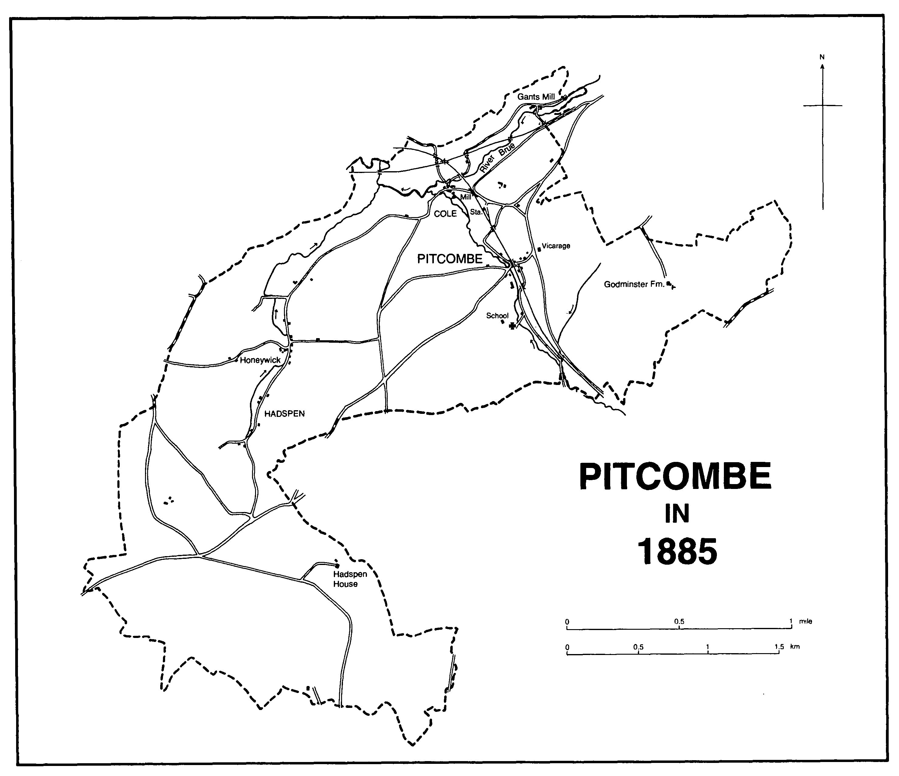
Pitcombe in 1885
In 1547 the manor was in the possession of John Zouche's grandson Richard Zouche (d. 1552) like Wincanton and Stavordale, although Richard's father John was said to hold it on his death in 1550. (fn. 51) Richard settled the manor on his two younger sons Richard and Charles. (fn. 52) They sold their shares respectively to Nicholas Wilkinson in 1570 and to Sir James FitzJames and William Cooke in 1571. (fn. 53) In 1575 FitzJames and Cooke sold their moiety to Wilkinson. (fn. 54) Nicholas (d. 1604) was succeeded by his brother Paul who by a succession of trust deeds settled the manor on himself for life with remainder to Edward, third son of William Wollascott. In 1627 Edward sold his interest to Henry Winchcombe. (fn. 55) Henry (d. 1629) was succeeded in the direct male line by Henry (d. 1643), (Sir) Henry (cr. Bt. 1661, d. 1667), and Sir Henry (d. 1703), all infants at succession. (fn. 56) In 1701 the last Sir Henry sold the lordship to Thomas Dawe and Joseph Guppy (d. 1734) and divided and sold the estate to various tenants, Dawe and Guppy acting as trustees. (fn. 57) In 1710 the lordship was said to be vested in Thomas and Robert Ludwell, William Russ, William Ridout, and William Ruddock for the remainder of a term of 99 years. (fn. 58)
The mill, church house, and other property were sold in 1701 to James White who in 1703 settled most of it on his marriage to Grace Cozens (d. by 1745). In 1745 Grace's nephew William Hayes Cozens released the estate to his sister Mary (d. 1756) and in 1751 it was settled on her marriage to William Rodbard (d. 1784). (fn. 59) They were followed by their son John (d. s.p. 1795) (fn. 60) whose cousin and successor Samuel Rodbard in 1798 claimed to be lord of the manor. (fn. 61) Lordship was not recorded thereafter and the estate passed with Grove farm to Samuel's daughter Anne, wife of James Talbot, Baron Talbot de Malahide, whose son, also James, sold his estates in Pitcombe to his brother-in-law Henry Hobhouse in 1858. (fn. 62)
An estate in Pitcombe and Cole, described as formerly monastic, was bought from the Crown in 1577 by Theophilus Adam and Thomas Butler who sold it in 1588 to Richard FitzJames. In 1602 Richard sold it to Nicholas Wilkinson and it was absorbed into Pitcombe manor. (fn. 63)
In 1701 Henry Winchcombe sold a house and lands to Susannah King who in 1714 left the estate to her sister Mary, wife of John Hall. In 1750 it was settled on Nathaniel Webb (d. 1782) of Roundhill in Wincanton, son and heir of Jane, daughter of Mary and John Hall. (fn. 64) The estate of 150 a., centred on Pitcombe House, north of the church, passed to Nathaniel's son, also Nathaniel (d. 1813), (fn. 65) who left it to his nephew Nathaniel Jekyll (d. 1826). Nathaniel's widow Sarah sold it in 1830 to Henry Hobhouse and it became part of the Hadspen House estate. (fn. 66)
The capital messuage was a large house of two storeys and attics with upper and lower drawing rooms and at least six bedrooms. It was destroyed by fire in 1827 and was never replaced. (fn. 67) Its gardens contained two ornamental canals. (fn. 68)
HONEYWICK may originally have formed part of Pitcombe but was a separate manor by 1207 (fn. 69) and was held of the Crown. (fn. 70) It belonged to the Lovel family by the mid 12th century and descended with Pitcombe. (fn. 71) It was last recorded as a separate estate in 1316. (fn. 72) By 1503 it had been absorbed into Castle Cary manor. (fn. 73)
From 1684 the lords of Castle Cary sold the Hadspen and Honeywick lands to tenants. Most of the land was later bought up by the Revd. Dr. John Wyndham. (fn. 74) In 1695 a large estate at Hadspen covering about 120 a. together with lanes and waste was sold to William Player. Player had already bought land in 1686 on which he built a house with barn, stables, oxhouse, and walled courtyards between 1687 and 1692. In 1703 he bought further land. Those formed the nucleus of the later Hadspen House estate. (fn. 75)
William Player (d. c. 1720) was succeeded in turn by his sons Arthur (d. s.p. 1728) and Thomas. The latter being heavily in debt and childless in 1731 obtained an Act of Parliament allowing him to sell the estate, apart from Arthur's widow's interest. (fn. 76) Hadspen House was bought before 1747 by Vickris Dickinson, who enlarged the estate. He sold it in 1767 to Charles Medows from whom it was bought c. 1775 by John Ford who in 1785 sold it to Henry Hobhouse. (fn. 77) Henry (d. 1792) was succeeded in the direct male line by Henry (d. 1854), Henry (d. 1862), and Henry (d. 1937). Sir Arthur, son of the last, died in 1965 and his trustees were followed by his grandson Niall Hobhouse, the owner in 1996. (fn. 78)
Hadspen House is of stone under a hipped, slate roof. William Player's late 17th-century house was remodelled by Vickris Dickinson c. 1750. (fn. 79) He probably added the parapet and central pediment and converted the mullioned and transomed windows to sashes. (fn. 80) Later in the 18th century the ground floor was replanned by John Ford, and Henry Hobhouse (d. 1792) perhaps raised the ceilings of the rooms on the main front. A large wing, in the style of the 18th-century front, was added to the west in 1886 and a smaller block, which included a garden room, was built on the east in 1909. (fn. 81)
William Player created formal gardens and courts around the house with two fountains, and planted avenues on three axes. On the hill behind the house he made plantations which in the mid 18th century were cut by vistas and ornamented with an artificial mount and a seat. (fn. 82) Except for the further part of the main double avenue, which survived until the later 20th century, stretching south-west from the house to the Yarlington boundary, much of the formal landscape was removed in the late 18th and 19th centuries (fn. 83) but terraces and formal gardens were created in the 20th century around the house and on Pen Hill, including a large walled area later associated with a commercial nursery. (fn. 84)
Player's late 17th-century stable survives, although much altered, together with his farmhouse and a number of 18th- and early 19th-century buildings.
In the mid 12th century Henry Lovel gave a virgate from his demesne at Honeywick to the canons of Bruton. (fn. 85) To that was added Geoffrey de Cary's gift of two parts of the tithes of Pitcombe which was confirmed before 1161 and Henry de Careville's gift of land in Pitcombe before 1194. (fn. 86) In 1541 the land was granted to (Sir) Maurice Berkeley at a reserved rent and in 1546 he obtained a grant in fee of the land and tithes, some of which had been let to farm. (fn. 87) Ownership descended like Bruton manor through the Berkeley family to Sir Richard Colt Hoare, Bt. (d. 1838), who sold most of the tithes to the landowners. (fn. 88)
GODMINSTER was probably owned by the Godmanston family during the 13th century. Robert de Godmanston had been succeeded by his son William before 1212. (fn. 89) William's son, also William, was dead by 1268 leaving a son William (fl. 1280). (fn. 90) By 1316 the last had been succeeded by Richard. (fn. 91) Robert de Godmanston was recorded in 1333. (fn. 92) The subsequent descent is not clear but Thomas de Godmanston (d. by 1410) was succeeded by his daughter Joan who in 1410 sold her estate in Bruton and Pitcombe to John Kingston. (fn. 93) Godminster was later acquired by Leonard Bosgrove (d. 1558) and descended with Discove. (fn. 94)
The south-eastern corner of Godminster Manor, formerly Farm, and much of the south front were rebuilt c. 1920 following a fire, but the earlier plan appears to have been retained. The south front has a two-bayed open hall at its centre with the screens, a newel stair, and former service rooms to the east and a gabled cross wing to the west. In the west wall of the hall there is a fireplace with a traceried stone bressummer of the 15th century. The southern ground floor room of the cross wing has a compartmented ceiling of the 16th century and there is plank and muntin walling on the first floor, but the north end was remodelled c. 1700 when a new western entrance front was added. It is of seven closelyspaced bays and the ground-floor windows have alternately segmental and triangular pediments. The kitchen, which is probably of 18th-century origin, is in the angle between the hall and the wing and the north side was completed by further service rooms after the fire. The large stone dovecot, for 840 birds, dates from the 17th century and has gables on all sides with some original windows. There is an 18th-century brick granary.
ECONOMIC HISTORY
In 1086 there were 5 ploughlands and 5 teams of which 2 were in demesne. Five villani and 19 bordars had the rest. There was 22 a. of meadow but no recorded pasture although demesne livestock comprised a riding horse, 6 unbroken mares, 12 cattle, 60 pigs, and 104 sheep. The estate was worth £7, reduced from £8 in 1066. (fn. 95)
In 1546 tithes of grain, hay, wool, and lambs from Honeywick and Hadspen were farmed, and also the tithe sheaves of Pitcombe's east field. (fn. 96) Fields in the east of the parish may have been shared with Bruton and in 1601 the south and east fields of Pitcombe and Holy Waters or Holy Fathers field were recorded. (fn. 97) Lynchets west of the church indicate the east field where some strips survived in 1801. (fn. 98) Hadspen and Honeywick had three open fields, west, south, and east, the latter probably shared with Pitcombe, which were probably inclosed from the later 17th century. (fn. 99) Lynchets survive west of Hadspen House which is built on the eastern edge of the former south field. (fn. 100)
During the 17th century the break-up of the Castle Cary manor estate in Hadspen and Honeywick gave rise to many small holdings. The existence of a limekiln and the right to dig marl in 1695 indicate improvements, probably when former open arable was inclosed by the new owners. (fn. 101) In 1717 the tenant of the Hadspen House lands had common pasture rights for 80 sheep in summer and further rights for animals marked with his landlord's initials. One estate still had rights to common sheep pasture in 1751. (fn. 102) By 1761 the commons at Hadspen were reduced and shortly afterwards were completely inclosed, leaving only some grazing on highways and wastes at Hadspen belonging to two landowners. (fn. 103) French grass and clover were sown in closes at Hadspen in the early 18th century and an 8-a. potato garden was recorded in 1763. (fn. 104) In 1781 former common land near Hadspen was described as coarse and poor but capable of improvement by marling at a cost of £200. Arable on the same estate was said to be worn out but recoverable in three years. (fn. 105)
In the 1770s Godminster farm supported 330 sheep, 41 cows, and 15 pigs and produced wheat, oats, peas, barley, vetches, beans, turnips, and clover using marl and lime. (fn. 106) Between the 1780s and 1800s the Revd. Dr. John Wyndham bought and exchanged small farms, fields, and cottage holdings in the west of the parish. (fn. 107) Considerable improvements were made in the provision of farm buildings and dwellings, levelling land, hedging, tree felling and management, and road repair and by the early 19th century Wyndham had turned his purchases into three large farms. He spent over £30,000 buying land and increased the rental from c. £200 in the 1780s to over £1,100 in 1820. (fn. 108) In the rest of the parish many small holdings remained but other landowners such as Samuel Rodbard were creating larger rack-rented farms by the 1800s. (fn. 109) By 1849 three quarters of the parish were owned by Henry Hobhouse (715 a.), Dr. Wyndham (582 a.), and the earl of Ilchester (292 a.), with the rest mainly in very small holdings. (fn. 110) By 1863 the Hobhouse and Wyndham estates had been further enlarged and the three largest landowners held all but c. 300 a. (fn. 111) The number of farms remained at between 10 and 13 during the second half of the 19th century although the number of labourers employed dropped from c. 85 in 1871 to 51 in 1881. (fn. 112)
In 1829 much cheese was produced by the Wyndham estate and tenants at Honeywick were required to practise a 3-year rotation of their arable and to keep a 'full' flock of sheep. (fn. 113) The former Pitcombe House estate was in poor condition when it was let as Pitcombe farm in 1832 and the tenant was promised a new farm house but had to plant clover in a system of 4-field husbandry. Three years later the land was described as of superior quality producing barley, wheat, turnips, and swedes, although it was still valued at less than the rent. (fn. 114) In 1863 farms in the parish produced wheat, barley, tares, swedes, mangolds, turnips, clover, rape, vetches, beans, and oats, and grew oak, beech, ash, and conifers. (fn. 115) Dairies were recorded in 1871 and 1881. (fn. 116) Rents fell sharply from the 1880s and some farmers were in difficulties. (fn. 117)
In 1898 Shatwell farm had a dairy herd of 71 cows, 315 Dorset Horn and Hampshire Down sheep with a South Down ram, 8 horses, 46 pigs, and poultry. Crops included several varieties of wheat and oats, barley, clover, swedes, mangolds, and turnips, c. 100 tons of good hay, and 170 bu. of apples from two orchards. (fn. 118) By 1905 there were 478 a. of arable and 1,440 a. of grass. (fn. 119) About 1928 Cole farm concentrated on dairying, with stalls for 25 cows and 5 piggeries. (fn. 120) In the 1920s Shatwell farm had a herd of 60-70 cows, 300 Dorset Horn sheep, pigs, and 150 a. of pasture. Wheat, oats, and barley were produced on 120 a., vetches, mustard, rye, turnips, swedes, and kale on 30 a., and butter and Cheddar cheese were made. There was a steam threshing barn and a new cowhouse. (fn. 121) In 1936 the farm produced 31,592 gallons of milk, increasing to 64,649 gallons in 1957 from a herd of 94 cows. (fn. 122) In 1948 Pitcombe farm was a dairy and cheesemaking farm with stalls for 46 cows and several pigsties. (fn. 123)
In 1086 5 a. of woodland was recorded. (fn. 124) There was probably anciently a large wood between Godminster and Discove of which two areas, Godminster and Lower Godminster woods (24 a.), remain. (fn. 125) Woodland surrounds Hadspen House and the 567 pollards cut down in 1800 may have been from ornamental avenues there. (fn. 126) In 1905 there was 114 a. of woodland in the parish. (fn. 127)
Limestone was quarried and burnt in several areas in the south-west from the 17th century and stone was quarried at Sunny Hill in the north-east in the 19th century. (fn. 128)
Linen cloth was woven in the parish in the 18th century, (fn. 129) and a yarn barton was recorded in 1801 at Cole. (fn. 130) A stocking maker was recorded in 1711. (fn. 131) During the 1820s the silk factory at Gants mill employed as many as 50 female apprentices, but in 1831 only 1 man and 45 women worked there and by 1841 87 people had left the parish following its closure. (fn. 132)
An edge tool manufacturer worked at Cole in 1803. (fn. 133) Twine makers were recorded in 1851, 1861, and 1881, a glover in 1861, and three horse-hair weavers in 1871, probably connected with the industry at Castle Cary. (fn. 134) There was a rakemaker at Hadspen in 1891, by which date 13 people were employed on the railway. (fn. 135) There was a general shop in the 20th century but it closed in the 1970s. By 1980 the schools in Bruton and Pitcombe were the major employers. (fn. 136)
Mills
Two mills were recorded in 1086. (fn. 137) One of those was probably east of the church and belonged to Pitcombe manor until the 19th century. (fn. 138) It was demolished before 1701 but had been rebuilt with a new house by 1703. (fn. 139) It was held with a small farm until 1803 when the mill, known as Pitcombe mill, was let separately to the Melhuish family who worked it until 1851 or later. (fn. 140) By 1854 it was in need of extensive repairs to both the building and machinery and in 1857 it was demolished as part of a scheme to build a new road. (fn. 141) The mill house survived until the 1880s. (fn. 142)
There was a mill at Cole in the late 13th century, possibly the second Domesday mill, but it is not clear whether it was the predecessor of Cole or Gants mills. (fn. 143) Cole mill was recorded in 1503 (fn. 144) and remained part of Pitcombe manor in 1651. (fn. 145) The house was rebuilt in the 17th century and the mill in the 18th. In the late 18th century it belonged to John Pounsett who married Jane, sister of the Revd. James Woodforde, the diarist. The mill passed to their daughter Jane, wife of the Revd. William Grove. (fn. 146) The mill was worked until 1939 or later (fn. 147) and the undershot wheel survives.
Before 1291 Hugh Lovel gave land at Cole north of the Brue to John le Gaunt with the right to make a sluice gate. John built mills including a fulling mill which he gave with land to his brother Walter. Walter had been succeeded by Thomas le Gaunt before 1333. (fn. 148) By 1351 the mill was known as Gaunt, later Gants, mill and was the property of Richard Prenche. Between 1356 and 1360 the fulling mill was rebuilt. (fn. 149) Richard gave the mill for life to his brother John Clark who granted it to Richard's son Edward Prenche in 1383. In 1385 Edward sold it to Hugh Plomer of Bristol (fn. 150) who in 1391 conveyed it to Thomas Tanner. From Tanner it was acquired by John Gregory in 1400. (fn. 151) John died in 1429 and his wife Amice before 1459. Amice's son Richard Weston appears to have released Gants mills to John's executors who in 1462 settled them on John Weston and his wife Edith. (fn. 152) John (d. c. 1476) was followed by his son Hugh (d. by 1546) (fn. 153) and by Sir William Weston (d. 1594) who left a son Thomas under age. The mill and lands were said to be in the demesne of Cole and held of Castle Cary manor. (fn. 154) Thomas (d. 1668) was followed by his son Thomas (d. 1669) and grandson William Weston. (fn. 155) William's son, also William (d. 1727), was succeeded by his second son Thomas who in 1733, after coming of age, sold the grist mill and fulling mill to William, Baron Berkeley. (fn. 156) It descended with Bruton manor. (fn. 157)
The mill was repaired in 1779 and in 1781 a new wheel was installed. (fn. 158) In 1783 it was let to the Melhuish family who bought it in 1799. In 1812 it was purchased by Theophilus Perceval, a silk throwster, who may have been responsible for converting it to a silk mill and building the seven-bay western extension, probably the new Denizen mill (fn. 159) recorded in 1824. Perceval worked it in partnership with successive silk throwsters. There were said to be 59 people living at the mill in 1821 but the business seems to have declined in the 1820s and by 1829 Perceval was bankrupt. (fn. 160) The Saxon family continued the business as tenants to the mortgagees until 1841. (fn. 161)
The building was vacated in 1842 and was put up for sale in 1844 as silk mills with grist mill. (fn. 162) It was let by 1851 as a flour mill by Edward Dyne, solicitor, who held the mortgages, (fn. 163) and from 1858 to 1949 it was worked by the Lockyer family who purchased it in 1924. (fn. 164) In 1949 the mill was sold to the Shingler family and continued in use in 1996, mainly for animal feed. (fn. 165)
The oldest part of the building, of uncertain date, lies across the stream and is now mostly occupied by the wheelhouse. A cross wing was added to the north in the later 18th century and it was remodelled early in the 19th when a long extension was built to the west. The miller's house appears to have been rebuilt in the early 19th century. The upper part of the old mill was rebuilt in the later 19th century and in 1883 an engine house was built to the south. The mill leet runs eastwards for about 0.5 km. and the old wheel was overshot. A steam engine was installed in 1883 and a turbine in 1888 but the mill was converted to diesel power in the 20th century and the steam engine and its chimney have been removed. (fn. 166) There are four sets of stones.
There was a mill at Honeywick in the later 17th century but it was not recorded again. (fn. 167)
In the 16th and 17th centuries there was a windmill near Godminster (fn. 168) where the names Windmill field and Windmill Hill were later recorded. (fn. 169)
LOCAL GOVERNMENT
From the later 13th century the parish was divided between two tithings of which one always included Honeywick and later also Hadspen, the other from the 1330s always both Pitcombe and Cole and until the 17th century also Wyke Champflower. (fn. 170) Each tithing appointed to each of the principal offices in the parish annually and separate accounts were kept and rates levied. (fn. 171)
In the 17th century Hadspen and Honeywick tenants owed suit to Castle Cary manor and the Hadspen tithingman was probably chosen there. In 1762 a foreman represented Pitcombe and Cole at the Castle Cary court leet. (fn. 172) There was a pound at Hadspen in 1770. (fn. 173) No manorial records have been found.
The parish had two wardens, two sidesmen, two overseers, and two highway surveyors, and a vestry by 1761. (fn. 174) A poorhouse was mentioned in 1799 and 1816. (fn. 175)
In 1835 the parish became part of Wincanton poor-law union which in 1894 formed part of Wincanton rural district and which was absorbed into Yeovil, later South Somerset, district in 1974. (fn. 176) The parish council, formed in 1894, erected gas lamps in 1908, probably on the Bruton road. Council houses were built at Pitcombe and Hadspen in the 1920s and 1930s. (fn. 177)
CHURCH
Pitcombe was at first probably a dependent chapel of the minster, and certainly of the later priory, at Bruton. The early 12thcentury font may be the earliest evidence for a church and may signify that partial independence had been achieved by then. The chapel was dedicated and endowed in or after 1197 (fn. 178) but remained dependent on Bruton priory (later abbey) until that was dissolved in 1539. (fn. 179) The living continued to be a sole curacy until c. 1840 when it was joined with Wyke Champflower. In 1879 union with Bruton was successfully resisted on the grounds that Pitcombe and Wyke were sufficient for one clergyman. It was separated from Wyke in 1929 and united with Shepton Montague. (fn. 180) From 1976 it was also held with Bratton. In 1985 it became part of the team ministry of Bruton and District. (fn. 181)
Chaplains or curates were presumably appointed by the canons of Bruton until the Dissolution (fn. 182) and thereafter by the owners of Bruton rectory (fn. 183) until 1959 when the advowson passed from the Hoare trustees to the bishop. Since 1985 the right of patronage has been vested in the patronage board of the team ministry. (fn. 184)
In 1541 the chaplain received a stipend of £5 a year; (fn. 185) it was said to have been increased to £20 in 1546, but possibly for additional duties. (fn. 186) In 1646 Sir Charles Berkeley was ordered to settle £30 a year on the minister of Pitcombe, who also served Wyke, and that sum was paid until 1657 or later. (fn. 187) It appears to have been reduced later to £10, but after 1785 was restored to £20. (fn. 188) In 1799 land at Ditcheat was bought with a grant from Queen Anne's Bounty, a further £200 was used to provide an £8 rent charge on land in Bruton, and another grant of £200 brought in £4 in interest providing a total stipend of £48 in 1826. (fn. 189) Average income c. 1830 was £85 (fn. 190) and a further augmentation was made in 1859 with £100, probably to build a house. (fn. 191) In 1919 Henry Hobhouse added a field to the glebe. (fn. 192)
There was no house in 1815 and clergy lived in the neighbouring parishes of Bruton or Brewham. (fn. 193) During the 1860s and 1870s the vicar leased a cottage at Hadspen which was occupied by his curate. (fn. 194) In 1859 Henry Hobhouse gave a site east of the Bruton-Sherborne road for a house which was finished by 1861 to designs by Ewan Christian. (fn. 195) It was replaced by a new house nearer the church built in the 1960s which ceased to be occupied as a clergy house in 1985. (fn. 196)
In 1623 Emmanuel Mason was presented for neglect of duty as curate, which included saying prayers before 8 a.m., but he remained in office until 1650 or later. (fn. 197) In 1654 his successor was said to have been interrupted in his ministry by ill-affected persons. (fn. 198) In 1744 there appears to have been a monthly communion. (fn. 199) The singers, recorded in 1761, visited Redlynch in 1788. (fn. 200) There was one service on Sundays in the 1780s. (fn. 201) In 1815 there was one service, alternately morning and evening, but by 1827 there were two. (fn. 202) Between 1840 and 1843 celebrations of communion increased from three to six times a year. (fn. 203) In 1851 attendance on Census Sunday morning was 42 with 41 Sunday-school children. Services had been reduced to one (fn. 204) but were restored to two by 1870 when communion was celebrated monthly. (fn. 205)
A church house was recorded on Pitcombe manor in 1652 but in 1701 it was sold. It was last recorded in 1716 but the field name Church House Tenement survived into the early 19th century west of the church. (fn. 206)
The church of ST. LEONARD, so dedicated by 1496, (fn. 207) was with the exception of the tower rebuilt in 1857-8 to designs by G. E. Street and has a chancel with north vestry, a nave with north aisle and south porch, and a west tower. (fn. 208) The earlier church had an undivided nave and chancel whose proportions and thick walls suggest that it was substantially of the 12th century. The tower was added in the late 15th or the early 16th century and there was a south porch of unknown date. (fn. 209) It was in bad condition in the 17th century (fn. 210) and many repairs were made in the early 18th century. There was a gallery with a representation of St. Cecilia painted in 1761. (fn. 211) The roof was carved with shields and cherubs. (fn. 212) Further repairs were carried out in 1805-6 (fn. 213) and in 1840 and 1843 the church was said to be in good repair although in 1857, before its demolition, it was said to be dilapidated. A larger churchyard and new road access were also required. (fn. 214) At the rebuilding two windows and some medieval glass were preserved as well as the 12th-century font and some early 17th-century bench ends. The carved reredos of 1907 is probably from Oberammergau. (fn. 215)
The church plate was given in 1842 and 1858. (fn. 216) The three bells are probably from the Bristol foundry, one dating from c. 1460, the other two from c. 1540. (fn. 217) The registers begin in 1538, except for marriages which are entered from 1567, and are complete. (fn. 218)
The late medieval churchyard cross was repaired in Doulting stone in 1758, apparently by making a new top. (fn. 219)
In 1930 a parish room at Hadspen was licensed for services and baptisms. (fn. 220)
NONCONFORMITY
The Cottington family of Godminster and others were recusants in the early 17th century. (fn. 221) A meeting-house licence was issued in 1699. (fn. 222) John Wesley visited Pitcombe in 1754. (fn. 223) Licences were issued for unspecified Protestant dissenters in 1828 and 1834, (fn. 224) and in 1841 for Wesleyan Methodists who had an average attendance of 35 at afternoon service in 1851. (fn. 225) Regular services ceased in 1856 but a house remained registered for use by Methodists in 1867. (fn. 226) Services were revived in 1890 and in 1892 a chapel was built on Mill Lane, (fn. 227) where two Sunday services and a Sunday school were held. The premises included a club room. (fn. 228) By the 1960s services were held less regularly and members attended Bruton chapel. In 1969 the society disbanded although occasional services were held until 1971. (fn. 229) Although Pitcombe chapel was disused, difficulties over its ownership deferred its official closure until 1976 when it was conveyed to the parish council. (fn. 230) In 1996 it was a private house.
EDUCATION
A Sunday school for female apprentices at Gants mill had 46 girls in 1818 and 54 in 1826. (fn. 231) In 1825 Nathaniel Jekyll of Pitcombe House gave land near the churchyard for a Sunday school which may have been re-established in 1833 when it had 77 pupils. (fn. 232) There were three private day schools in 1833 teaching 24 children. (fn. 233) Only one school was recorded in 1847 when 64 children were taught, 7 of them on Sunday only. It was probably held in the Sunday schoolroom by the churchyard. (fn. 234) In 1864 the vestry accepted Arthur Hobhouse's offer to build a new schoolroom further to the northwest, and incorporated the site of the old into the churchyard. (fn. 235) In 1883 average attendance was 34 and by 1903 there were 63 children on the books. (fn. 236) In 1939 the school became a county school. Although average attendance was high numbers had fallen to 30 in 1945 and 13 in 1949 when it closed. (fn. 237) It became a private house. (fn. 238)
Bruton School for Girls, Sunny Hill, was built in 1900 and became a public school for 150 girls in 1912. In 1996 it was a day and boarding school for girls aged 6 to 18. (fn. 239)
There was a boarding school at Hadspen in 1861. (fn. 240) Part of Hadspen House was used as a school in the late 1930s. (fn. 241)
CHARITIES FOR THE POOR
By will of 1714 Susanna King gave £80 for poor widows and maidens which was invested in rent charges of which £4 was distributed at Easter until the 1930s or later. (fn. 242) Sarah Hobhouse, by will proved 1810, gave £200 which was invested in stock for the sick poor of Hadspen. The income was distributed by the Hobhouse family during the 19th century (fn. 243) and by 1931 by the district nurse. (fn. 244) Further gifts from Eleanor Hobhouse (d. 1843) for the sick and aged of the parish and from Sarah Campbell by deed of 1858 were invested in £29 and £119 of stock. Half the Campbell charity income was distributed in clothing and blankets in 1894. (fn. 245) Eleanor Hobhouse's gift was not recorded in 1931 and these charities appear to have been lost. (fn. 246)