A History of the County of Somerset: Volume 7, Bruton, Horethorne and Norton Ferris Hundreds. Originally published by Victoria County History, London, 1999.
This free content was digitised by double rekeying. All rights reserved.
'Marston Magna', in A History of the County of Somerset: Volume 7, Bruton, Horethorne and Norton Ferris Hundreds, (London, 1999) pp. 131-138. British History Online https://www.british-history.ac.uk/vch/som/vol7/pp131-138 [accessed 18 April 2024]
In this section
MARSTON MAGNA
The parish, which probably takes its name from the marshland between the village and the river Yeo, was formerly known as Broad Marston to distinguish it from Little Marston in neighbouring West Camel (fn. 1) and sometimes as Marston Beauchamp after the lords of the manor. (fn. 2) It lies 7 km. north-east of Yeovil and was roughly rectangular in shape, measuring 2 km. from north to south and 2.5 km. from east to west at its widest point. The western and parts of the southern and eastern boundaries follow roads; most of the northern boundary the Lambrook or Hornsey Brook. Marston village lay near the centre of the parish, with the former farmstead or hamlet of Netherton and the former park to the south-east. (fn. 3) The ancient parish measured 1,068 a. (fn. 4) but in 1885 Nether Adber, an unpopulated area of Queen Camel to the south, was transferred to Marston. (fn. 5) The present parish covers 563 ha. (1,391 a.). (fn. 6)
Most of the parish is below the 30-m. (98-ft.) contour and the highest point is 37 m. (121 ft.) near the eastern boundary. (fn. 7) It lies largely on sandy loam with limestone and gravel but there is Lower Lias clay to the north-east where marl was probably dug in the late 18th century. There are bands of alluvium along the mill stream in the east. (fn. 8) In c. 1788 blue stone containing specimens of violet cornu ammonis was found in a marl pit in blocks large enough to cut into slabs for furniture. (fn. 9)
A bronze spearhead was found c. 1881 in the extreme south-west of the parish. (fn. 10) The core of the medieval village lay around the junction of an east-west street, part of a 'herpath' from Corton Denham and Rimpton in the 950s, (fn. 11) with a north-south route from Queen Camel to Sherborne (Dors.). The northern part of the road, from the church northwards, was known as Camel Street. The southern part appears to have been abandoned in favour of a less direct route further west, perhaps because an increase in the importance of the market at Yeovil led to growth in traffic from the village using the Portway running south from West Camel and forming part of Marston's western boundary. (fn. 12) The Queen Camel-Sherborne road was turnpiked in 1801 by the Sherborne trust but in 1852 the road north of the Marston inn was transferred to the Ilchester trust (from 1856 the Yeovil and Ilchester trust). The Yeovil road, which divides from the Sherborne road at the Marston inn, was probably also turnpiked by the Sherborne trust but was taken over by the Yeovil trust in 1852. (fn. 13) In 1856 the Great Western Railway Co. opened a line from Chippenham (Wilts.) to Yeovil and Weymouth (Dors.) and a station was opened east of the village. Settlement extended eastwards towards the station in the 19th and 20th centuries. The station closed in 1966 but the line remained open in 1994. (fn. 14)
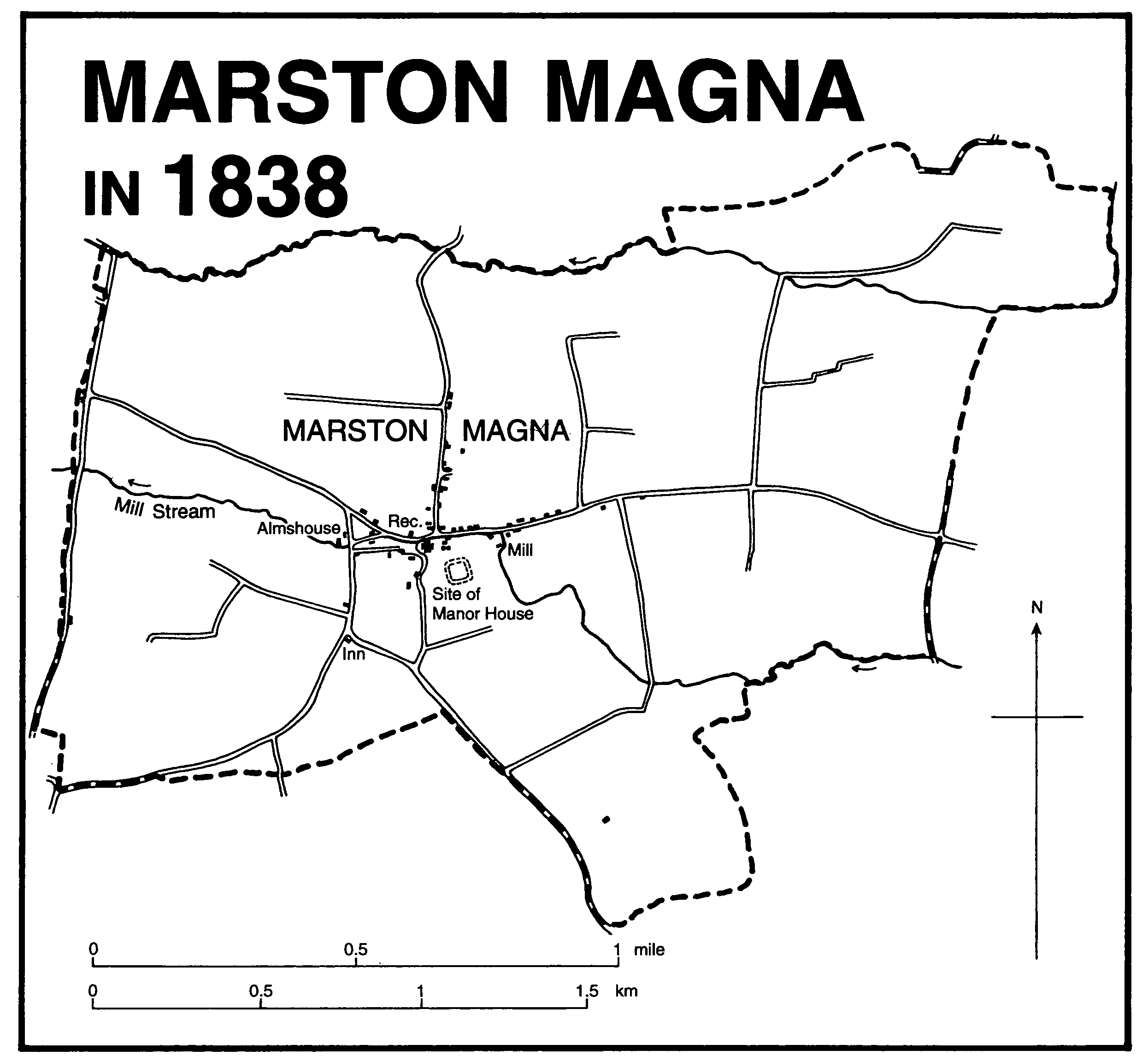
Marston Magna in 1838
Older houses are of coursed stone, some with Ham stone dressings. Manor House dates from the 16th century but was remodelled in the 17th with a 6-bayed front. (fn. 15) There are several 17thcentury houses including two west of the church and others in Camel Street. The 17th-century north wing of Marston Court was in 1927 made part of a large Tudor-style mansion. (fn. 16) Most later 20th-century housing has been built west of the village. Several cottages stood near Lambrook bridge where the road to Queen Camel crosses the Lambrook. (fn. 17) The bridge was recorded in 1755, was rebuilt in 1827, and was replaced in 1961. (fn. 18) The houses were demolished before the 19th century. (fn. 19) Netherton, south-east of the village, gave its name to a medieval family (fn. 20) and was described as a 'head place' in the early 16th century. (fn. 21) It was probably a single farmstead. (fn. 22)
There was an inn in 1669, (fn. 23) perhaps the Old Inn recorded between 1683 and 1700. (fn. 24) The New Inn, possibly in Camel Street by 1690, was probably one of the three in business in 1731. From 1765 there was only one inn, the Old Angel on the junction of the roads to Sherborne and Yeovil. (fn. 25) It appears to have been renamed the Marston inn in 1805, possibly following rebuilding, (fn. 26) and in 1906 had commercial, coffee, and club rooms, and stabling for 10 horses. (fn. 27) It remained in business in 1994. The Red Lion, between the village and the former railway station, was probably in business from 1859 (fn. 28) and remained open in 1994. There was a beerhouse in Camel Street between 1851 and 1866. (fn. 29)
In 1548 there were 140 communicants in the parish (fn. 30) and 171 poll tax and subsidy payers in 1641. (fn. 31) In the 1780s many houses were said to be uninhabited. (fn. 32) In 1801 the population numbered 303, reached 387 in 1851, and fell from 383 in 1871 to 305 in 1881 and to 271 in 1901. Thereafter numbers fluctuated before rising to 393 in 1971, to 466 in 1981, and to 473 in 1991. (fn. 33)
MANOR AND OTHER ESTATES
Before 1066 MARSTON was held by several thegns. By 1086 it was held by Robert, count of Mortain. (fn. 34) Robert (d. 1090) was followed by his son William, who lost his lands for rebellion in 1106. (fn. 35) The manor presumably escheated to the Crown, but before 1170 had been held by Richard FitzOdo and before 1186 by William son of John de Molariis. It was in Crown hands between 1170 and 1173 and from 1188 onwards (fn. 36) until 1206 or later, but by 1196-7 seems to have been occupied in the name of Robert, son of Simon Vautort (d. 1199), by a daughter of Robert de Beauchamp (d. 1195). (fn. 37) Robert Vautort came of age c. 1212, took the name Beauchamp, and died in 1251. (fn. 38) He and his successors held the manor as part of their barony of Hatch Beauchamp, but it was said in the mid 14th century to be held of the earls of Hereford, probably because other Beauchamp estates were so held. The earldom was subsumed in the Crown in 1399. (fn. 39) In 1606 the manor was said to be held in chief. (fn. 40)
Robert de Beauchamp was followed after his death in 1251 in the direct male line by Robert (d. 1264), John (d. 1283), John (d. 1336), and John (d. 1343). (fn. 41) The first had by 1236 granted the manor for ½ fee to Robert of Netherton. (fn. 42) A namesake did homage for the same estate in 1337 and was still in possession in 1343. (fn. 43) By 1361 the holding, reduced to ¼ fee, had passed to Thomas Fraunceys, possibly in succession to John Fraunceys. (fn. 44)
By 1363, however, the manor had been resumed by the lord and in that year it was held by Cecily, daughter and coheir of the last John de Beauchamp. Ten years later it had passed to Sir John Meriet (d. 1391), son of Cecily's sister Eleanor. (fn. 45) Sir John settled it on his wife Maud for her life with remainder to their daughter Elizabeth (d. c. 1395 s.p.), wife of Urry Seymour. (fn. 46) Elizabeth's heirs divided the family estates and Marston manor passed to her cousin Elizabeth, stepmother of Sir Humphrey Stafford (d. 1442) of Southwick (Wilts.). (fn. 47) Sir Humphrey was followed in direct succession by his son William (d. 1450) and his grandson Humphrey (cr. Lord Stafford of Southwick 1461, earl of Devon 1469, d. 1469). On the execution of the last the manor seems to have passed to one of his coheirs, Anne, wife of John Willoughby. (fn. 48) The descent is not clear but in 1533 the manor was occupied by Sir Anthony Willoughby (fl. 1541), younger brother of Anne's grandson Robert, Lord Willoughby (d. 1521). (fn. 49)
In 1582 the manor was conveyed by William Lambert and his wife Elizabeth to John Lennard. (fn. 50) John (d. 1591) was succeeded by his son Sampson and his grandson Henry. (fn. 51) Henry sold the manor in 1596 probably to trustees of Anthony Stapley. In 1606 Stapley died leaving a son, also Anthony, under age. (fn. 52) In 1618 the younger Anthony and his wife Anne sold the manor to John Whitfeld. (fn. 53) John (d. c. 1636) was succeeded by his son Thomas (fn. 54) and Thomas by his son of the same name by 1643. (fn. 55) Thomas the younger sold off land to tenants and in 1645 conveyed the lordship to John and Robert Hunt. (fn. 56) In 1683 John Hunt sold it to Sir John St. Barbe, Bt. (fn. 57)
Sir John (d. 1723) made his great-grand nephew Humphrey Sydenham of Combe his heir. Humphrey died in 1757, (fn. 58) and in 1765 his widow Grace released the manor to her son St. Barbe Sydenham. (fn. 59) St. Barbe (d. 1799) settled his estates on his daughter Catherine (d. 1794) for her marriage to Lewis Dymock Grosvenor Tregonwell. (fn. 60) In 1814 half the manor was settled on Catherine's daughter Helen for her marriage to John Duff Markland but the other half appears to have been retained by Lewis (d. 1832) and his son St. Barbe. In 1833 St. Barbe Tregonwell and John Markland were joint lords. (fn. 61) In 1839 St. Barbe sold his half to John Markland when the whole estate measured c. 100 a. (fn. 62) John was dead by 1853 and Helen sold the manor. (fn. 63) In 1861 James Parsons was said to be lord and his representatives claimed lordship in 1906, but it was not recorded again. (fn. 64)
The moated medieval manor house site, known as Court Garden, lies south-east of the church and was separated from the manor before the mid 18th century. It may have been abandoned before the end of the Middle Ages. (fn. 65)
In 1457-8 Richard Milborne paid ½ lb. wax rent to the lord of the manor. (fn. 66) George Milborne (d. 1559) had an estate in Marston in 1545 including a house and lands and was succeeded by his son Giles (d. c. 1575). Giles left an infant son George. (fn. 67) In 1648 it was held by George's eldest son John Milborne (d. c. 1664) who in 1654 settled his estates on his eldest son William (d. c. 1662). William's heirs were his brothers Charles and George. (fn. 68) In 1682 it was settled on Charles's son Charles, and in 1686 with Sir John Pye, Bt., he conveyed it to John Martin, the tenant. (fn. 69) It has not been traced further.
About 1100 William, count of Mortain, gave the tithes of the demesnes to Montacute priory. (fn. 70) By 1291 Montacute received a pension of 7s. out of the rectory, (fn. 71) which by 1535 had been reduced to 6s. 8d. (fn. 72)
In 1198 the rectory was said to have been appropriated to Polsloe priory (Devon) (fn. 73) and was held by the priory, usually let to farm, until 1538. (fn. 74) The Crown continued to let the rectory (fn. 75) but before 1593 it was acquired by Edmund St. Barbe (d. 1593) who was succeeded in turn by his sons Francis (d. 1599) and Henry (d. by 1653). (fn. 76) Henry's son John (d. 1658) was followed in turn by his sons Henry (d. 1661) and John (cr. Bt. 1663, d. s.p. 1723). John left his estates to his kinsman Humphrey Sydenham who, in accordance with John's wishes, gave the rectory to the vicar of Marston in 1736. (fn. 77) By the 18th century the rectory appears to have consisted of a house, 4 a. of land, and tithes. (fn. 78)
ECONOMIC HISTORY
In 1086 Robert of Mortain's estate which T.R.E. had been assessed at 5 hides, had 5 ploughlands in 1086. Two hides and 3 virgates were in demesne with 1 ploughteam worked by 1 servus, and the rest of the land was held by 5 villani and 10 bordars with 3 ploughteams. There was 40 a. of meadow but no recorded pasture. Demesne livestock comprised one riding horse and 16 pigs. (fn. 79)
There was 30 a. of woodland in 1086. (fn. 80) Fayrewode, probably in the north-east, was recorded in 1457, (fn. 81) and in 1700 there was at least a 32-a. wood. In 1839 no woodland was recorded, but there was 9 a. in 1905, probably Marston Covert. (fn. 82)
In 1171 the demesne supported cattle and pigs (fn. 83) and in 1195-6, 1206-7, and 1287 surplus corn was sold. (fn. 84) In 1361 the manor included at least 150 a. of arable and 40 a. of meadow. (fn. 85) By 1457 the demesnes appear to have been let but some meadow was mown to feed the steward's horses. Nearly £38 was received in customary rents; some holdings were in hand and others paid reduced rents. (fn. 86) Farmers in the early 16th century produced malt as well as keeping cattle and sheep (fn. 87) although tithes of wool and lambs produced only 13s. 4d. in 1535. (fn. 88) In 1633 Marston was 'notable for rich grounds' and the vicar received tithes of wool, lambs, calves, unprofitable beasts, orchards, onions, dairy produce, eggs, pigs, and geese. (fn. 89)
By the late 16th century most land appears to have been inclosed and although common pasture in the park was recorded in 1665 it had been excluded from at least some leases by 1635. (fn. 90) The park covered 54 a. in 1739 and had been divided into fields by 1838. (fn. 91) There was common meadow at Broadmead in the south of the parish until the mid 17th century. (fn. 92) Common pasture on 25 a. of Marston Lains or Common in the north-east of the parish, recorded in 1591, may have been shared with West Camel. (fn. 93) It had been inclosed before it was sold in 1641. In 1686 men of Rimpton were accused of taking soil from the commons but no common land was recorded in 1700. (fn. 94)
The break-up of the manor estate in the 17th century led to the creation of several small farms including Northern Town, and the later Wickham farm, (fn. 95) and also Marston Park farm, the former park. (fn. 96) In 1700, apart from cottages, there were 28 holdings on the manor of which probably only two were over 50 a. (fn. 97) By 1839 Wickham farm, with a 17th-century farmhouse in the village, measured 66 a. and Park farm 74 a. (fn. 98) Among the farmers were George Raymond (d. c. 1747) who kept a dairy and made cider. (fn. 99) Another in 1788 produced 144 stone of flax. (fn. 100) In 1801 191 a. of arable was recorded, mainly under wheat (97 a.) but also barley, oats, rye, turnips, peas, beans, and potatoes. Wheat yielded 27 bu. to the acre and barley 35 bu. The potato crop was abundant and the peas were said to be the best for many years. (fn. 101) In 1836 there were said to be fine orchards and good pasture. (fn. 102)
In 1839 there were 684 a. of grass, 295 a. of arable, and 71 a. of orchard. There were 24 holdings over 10 a., including 12 under 25 a., 5 between 25 a. and 50 a., 6 between 50 a. and 100 a. and only 1 over 100 a. (fn. 103) In 1851 of 7 farms, 2 were over 100 a. and only 1 under 50 a. but by 1861 there were 8 farms of which half had 40 a. or less. (fn. 104) By 1881 the number of small farms had declined and the three largest farms had between 200 a. and 300 a. (fn. 105) In 1851 15 labourers were employed on 7 farms, but by 1861 20 labourers were employed on 8 farms. (fn. 106) In 1868 there was said to be hardly a boy under 10 in regular work. (fn. 107) By 1881 only 18 labourers were employed. (fn. 108) In 1861 a dairyman employed two dairymaids. (fn. 109)
In 1905 most of the parish (904 a.) was under grass with only 93 a. of arable. (fn. 110) Cheese was made on at least one farm in the parish in the 1920s. (fn. 111) In 1965 Wickham farm with over 100 a. was mainly laid to grass but produced 11 a. of barley and smaller acreages of wheat, potatoes, mangolds, and kale. Stock comprised 76 Friesian cows and calves, 15 Landrace sows and a boar, 335 deep litter poultry, and 115 cockerels, ducks, and turkeys. Produce included 49,128 gall. of milk, 250 bacon pigs for slaughter, and 300 dozen eggs. The farm was self sufficient in fruit and vegetables. A dairy farm in 1975 had 50 milking cows. (fn. 112) In 1988 the parish was largely under grass, supporting 843 cattle, 141 sheep, 187 pigs, and 55 poultry. Half the 10 farms in the return were classed as part-time and three were dairy farms; only 3 were over 50 ha. (124 a.) and 3 were under 10 ha. (25 a.). A total of 19 workers was employed. (fn. 113)
In 1851 there were 14 glovers and in 1861 3 glovers and a male lace maker. Glovers were recorded in 1871 (fn. 114) and some gloving was said to have been carried out in the 1960s. (fn. 115) The railway brought employment and by 1871 the Somerset Trading Company at the station sold coal, coke, timber, and slates. Other occupations in the later 19th century included a timber merchant, a cabinet maker, and a cooper. (fn. 116) In 1891 the Western Counties Creamery moved to Marston from Rimpton and in 1898 amalgamated with Aplin and Barrett of Yeovil. Production of cream moved to Yeovil c. 1925 and the buildings were used by the adjoining cider factory. (fn. 117)
The proprietors of the creamery produced cider in the 1890s and in 1901 established the Magna Cider Company. (fn. 118) By 1924 the factory supplied several types of cider, notably 'Magna - Medium Sweet', which was exported to Australia. The company also produced apple chutney, apple pulp, and boxed apples. (fn. 119) It was bought by Showerings Ltd. in 1959 and cider production was transferred to Nailsea. In 1961 a winery was built on the site, employing 32 people by 1965. It specialized in fermentation and bulk processing for the manufacture of British wines and in 1992 it became part of the Gaymer group. (fn. 120)
Mills
In 1199 there were two mills. (fn. 121) One was probably the customary mill recorded in 1361, 1726, and later. (fn. 122) In the 1920s when it was sold the mill had a bakehouse and was worked by a water-powered turbine. Equipment included Peak and French stones, an oat bruiser, and a bean kibber. Milling appears to have ceased soon after the sale. (fn. 123)
The mill house dates from the 18th and 19th centuries and there is a pit probably for an overshot wheel. Some milling equipment survived in 1988. (fn. 124)
Fair
In 1248 Robert de Beauchamp received a grant of a three-day fair at the feast of St. Martin (11 Nov.) (fn. 125) and in 1260 a grant of a Tuesday market (fn. 126) which it was claimed would harm the market at Ilchester. (fn. 127) There is no record of the fair or market being held, but in the 13th century Robert de Beauchamp freed Bruton priory from toll when buying and selling in Marston (fn. 128) and in 1287 tenants of Stoke sub Hamdon obtained seed corn in Marston and drove cattle there. (fn. 129) In 1861 there was said to be a fair in 'Advent week' but it was not recorded again. (fn. 130)
LOCAL GOVERNMENT
The tithing of Marston comprised the whole parish and Little Marston in West Camel. (fn. 131) In the late 17th and the early 18th century the tithingman, appointed in the manor court, guarded prisoners and in 1698 looked after the militia equipment. (fn. 132)
A court leet was held for the manor and a court book survives for the period 1683-1700. The manor appointed a hayward and was especially concerned with bridges and ditches. Between 1691 and 1700 the jury presented the pound next to the churchyard as in need of repair and additionally in 1700 the stocks. (fn. 133)
In 1789 the vestry agreed to inoculate the poor against smallpox. The overseers in the late 18th century provided relief in cash and in kind including coal and clothing. They also paid for a year's teaching for the singers and for a Sunday school teacher. (fn. 134) In 1813 the vestry considered providing a poorhouse but seems to have relied on renting cottages. In 1843 the vestry decided to pay no more cottage rents. (fn. 135)
In 1835 the parish became part of Sherborne poor-law union, in 1896 of Yeovil poor-law union and rural district, and in 1974 of Yeovil, later South Somerset, district. (fn. 136)
CHURCH
The church has traces of 11th-century masonry in its fabric. (fn. 137) The living was appropriated to Polsloe (Devon) priory in 1198 and a vicarage was ordained in the 'time of Henry III'. (fn. 138) The living remained a sole cure until 1932 when it was united with Rimpton. (fn. 139) Between 1980 and 1987 the united benefice was held with Queen Camel, West Camel, and Corton Denham but from 1987 was held with Chilton Cantelo, Ashington, and Mudford. (fn. 140) The parish had given its name to the rural deanery of Merston by 1291. (fn. 141)
The advowson was held by Polsloe priory until 1538, and thereafter by successive owners or tenants of the rectory who after 1683 were also lords of the manor. (fn. 142) In 1783 it was assigned to Margaret Williams in trust to present her nephew John Williams. (fn. 143) In 1839 the term was surrendered to the lords of the manor. (fn. 144) By 1861 the advowson was in the possession of Capt. Shipton R.N. (fn. 145) and in 1875 of the Revd. Dr. Marriner. (fn. 146) In 1885 it was exchanged for the advowson of Barrington by the Revd. Vincent Coles with the dean and chapter of Bristol, and the chapter presented at every second turn between 1932 and 1979. Since 1979 they presented at every third turn. (fn. 147)
In 1291 the church was valued at £16 6s. 4d. (fn. 148) The vicarage was endowed with £8 (fn. 149) but in 1535 was valued at £6 13s. 4d. gross (fn. 150) and at £10 a year in 1548. (fn. 151) It was reputed to be worth £30 c. 1670. (fn. 152) In 1705 the vicar received 29 bu. of wheat from the rector and others and £2 from the rector alone. The living was then said to be worth about £25 (fn. 153) but in 1707 between £17 and £22. (fn. 154) In 1720 Sir John St. Barbe proposed to endow the vicar with tithes worth £200 to match the same amount to be given by Queen Anne's Bounty. The proposal may not have taken effect and instead in 1736 the rectory estate was combined with the vicarage. (fn. 155) In 1829-31 the average income was £390 gross. (fn. 156)
In 1535 the vicarial tithes and offerings were valued at £3 13s. 4d. gross (fn. 157) and in 1633 the vicar had part of the tithe of herbage of 25 a. said to have been in West Camel. (fn. 158) In 1839 the whole tithes of the parish were commuted for a rent charge of £305. (fn. 159) In 1535 no glebe was recorded (fn. 160) but in 1571 the vicar had meadow, orchard, and garden totalling 1½ a. (fn. 161) In 1707 the glebe was valued at between £1 and £2 13s. (fn. 162) and in 1736 the vicar received 4 a. of rectorial glebe in return for annual prayers in Passion week. (fn. 163) In 1839 the glebe measured 87 a., presumably the former rectorial estate, (fn. 164) but the total had been reduced to 22 a. by 1906 and to 3 a. by 1923. (fn. 165)
The vicarage house was reported decayed in 1557 (fn. 166) but in 1606 comprised hall, buttery, kitchen, dairy, and upper rooms. (fn. 167) In 1736 the vicar was given the rectory house and the vicarage house north of the church was used as a school and teacher's house. It fell down between 1786 and 1789. (fn. 168) The rectory house, probably rebuilt in the later 18th century, was considered fit in 1815 (fn. 169) and in 1818 the gardens were greatly admired. (fn. 170) It is of stone and stands north-west of the church. It was sold in 1979 and thereafter the vicar lived at Queen Camel until 1987 after which at Mudford. (fn. 171)
There was a brotherhood associated with the Lady Chapel whose stock in 1523 was more than twice that of the church. (fn. 172) It was last recorded in 1544. (fn. 173) In 1552 a parishioner left money for a dirge 'if it shall stand with the king's proceedings', and if not the money was to be distributed to the poor. (fn. 174) In 1584 the vicar, William Appowell, was accused of loose behaviour, drunkenness, demanding excessive Easter offerings, neglecting his duties, and conducting marriages without banns or licence. (fn. 175) The church fabric was also neglected. (fn. 176) In 1606 several parishioners were presented for playing fives and bowls in the churchyard on the Sabbath. (fn. 177)
During the 17th, 18th, and 19th centuries Ashington and Marston were either served or held together. (fn. 178) John Williams, rector 1786-1842, held other livings but was resident. (fn. 179) He restored the church and the rectory gardens and provided almshouses. (fn. 180) In the 1780s there were 15 communicants. In 1815 and 1840 two Sunday services were held and communion was celebrated four times a year. (fn. 181)
The church of ST. MARY, so dedicated by 1505, (fn. 182) is built of lias rubble with ashlar dressings and has a chancel, a nave with north chapel and south porch, and a west tower. There is some re-set 11th-century work above the chancel arch. The relatively long chancel has clasping buttresses and a triplet of narrow lancets in the east wall suggesting a date early in the 13th century. There are a 14th-century window and a priest's doorway in the south side of the chancel and the chancel arch may also be of that date. The porch and the nave windows are all of the 15th century and the north chapel, which is at the west end, was added later, and was the Lady Chapel between 1506 and 1544. (fn. 183) It was endowed to maintain a 'devotion' priest. (fn. 184) In the chapel is a niche in the north-east corner and traces of medieval wall paintings. Before 1818 tracery was removed from the chapel. (fn. 185) The tower is probably contemporary with the nave windows. In 1828 the church was said to have been 'repaired and beautified' at the vicar's expense. The porch was used as a vestry and there were two galleries. (fn. 186) Restoration in 1902 by Charles Ponting removed the galleries. (fn. 187)
Fragments of medieval glass survive in the south chancel window. Among the fittings are an arcaded Norman font, fragments of 15th-century woodwork in the chapel screen, possibly the chancel screen recorded in the 1780s, (fn. 188) and the heavily renewed 18th-century pulpit. In 1791 there was a reading desk in memory of John Rowswell, vicar 1519-42. (fn. 189)
There are six bells of 1912. (fn. 190) The plate includes a cup of 1573 by 'I. P.' (fn. 191) The registers date from 1562. (fn. 192)
NONCONFORMITY
Between 1673 and 1700 Quaker meetings were held in the parish. (fn. 193) A meeting house was licensed in 1689. (fn. 194)
In 1825 and 1842 houses were licensed possibly for use by Methodists. (fn. 195) In 1829 Marston was in the Sherborne Wesleyan circuit (fn. 196) and in 1882 a chapel was built. It remained open in 1994. (fn. 197) A Primitive Methodist chapel was recorded with no members in 1855. (fn. 198)
EDUCATION
In 1662 a man was licensed to teach grammar in the parish. (fn. 199) In 1736 the transfer of the rectory estate to the vicar included the establishment of a day school for five poor boys from the parish and five from Ashington. (fn. 200) It was still in existence in the early 1780s but may have ceased when the building fell down before 1789. Two nearby cottages on the glebe were fitted out for a school in 1813, but the number of pupils had been reduced to eight in 1818 and 1825. (fn. 201) A new building was erected probably between 1838 and 1846 beside the former school. In 1846 it had 45 day children, with a further 25 on Sundays only and a Sunday evening school attended by 15 boys. (fn. 202) The school, affiliated to the National Society, continued to be supported by the vicar until 1879 or later. (fn. 203) The school had 46 children in 1905, 28 in 1935, having become a junior school in 1926, and 23 in 1945. The school closed in 1951 and the children transferred to Queen Camel. (fn. 204)
In 1802 the vestry paid a mistress to teach 10 boys and 10 girls on Sundays. (fn. 205) The Sunday school continued in 1833 but probably closed when the National school opened. In 1833 there were also a mixed infant school with 15 children and two boarding schools with 12 boys and 29 girls, opened since 1818, and a further two day schools which taught 27 children at their parents' expense. (fn. 206) In 1846 a dame school taught 12 children. (fn. 207)
CHARITIES FOR THE POOR
An unknown donor gave £7 for the poor to which was added £10 given by Thomas Palmer (d. 1815) to five men and five women not receiving relief and £6 by Mrs. Palmer (d. 1839). (fn. 208) Those charities were distributed regularly until 1939 (fn. 209) but appear to have been lost since. (fn. 210)
In 1841 the Revd. John Williams, rector 1786-1842, gave three cottages to be used as almshouses for the aged poor, and in 1861 his daughter Frances Cox gave £100 to provide them with coal. (fn. 211) The almshouses stood on the west side of the village but were demolished after 1939. (fn. 212) Since 1959 fuel and other articles have been given to the aged poor of the parish belonging to the Church of England. (fn. 213)