A History of the County of Somerset: Volume 7, Bruton, Horethorne and Norton Ferris Hundreds. Originally published by Victoria County History, London, 1999.
This free content was digitised by double rekeying. All rights reserved.
'Cucklington', in A History of the County of Somerset: Volume 7, Bruton, Horethorne and Norton Ferris Hundreds, (London, 1999) pp. 177-184. British History Online https://www.british-history.ac.uk/vch/som/vol7/pp177-184 [accessed 24 April 2024]
In this section
CUCKLINGTON
The ancient parish of Cucklington lies on the south-eastern edge of the hundred and county, bordering on Dorset. (fn. 1) The village of Cucklington and Clapton farm were both Domesday settlements. (fn. 2) The parish, which is roughly pearshaped, measures 4 km. from north to south and 3 km. from east to west at its widest point. Its western boundary is a stream, known by 1208 as Sewardeslake, (fn. 3) which divides it from Stoke Trister, and a stream also marks part of the boundary in the east with Gillingham and Silton (Dors.). In 1841 it was reckoned at 1,780 a.; (fn. 4) in 1981 the area was 727 ha. (1,796 a.) and in 1991, after transfer of a field to Penselwood, 722 ha. (fn. 5)
The village of Cucklington, and Clapton and Clinger farms lie on the west-facing scarp which divides the parish. To the east, a plateau of clay and limestone rises to above 150 m., at isolated points above 160 m., followed by a gradual fall to the parish and county boundary. The narrow and steep scarp, mainly of clay but affected by landslip in the north, falls rapidly to 100 m. and then more gradually to just under 70 m. at the western boundary over Oxford Clay and Kellaway Beds. (fn. 6)
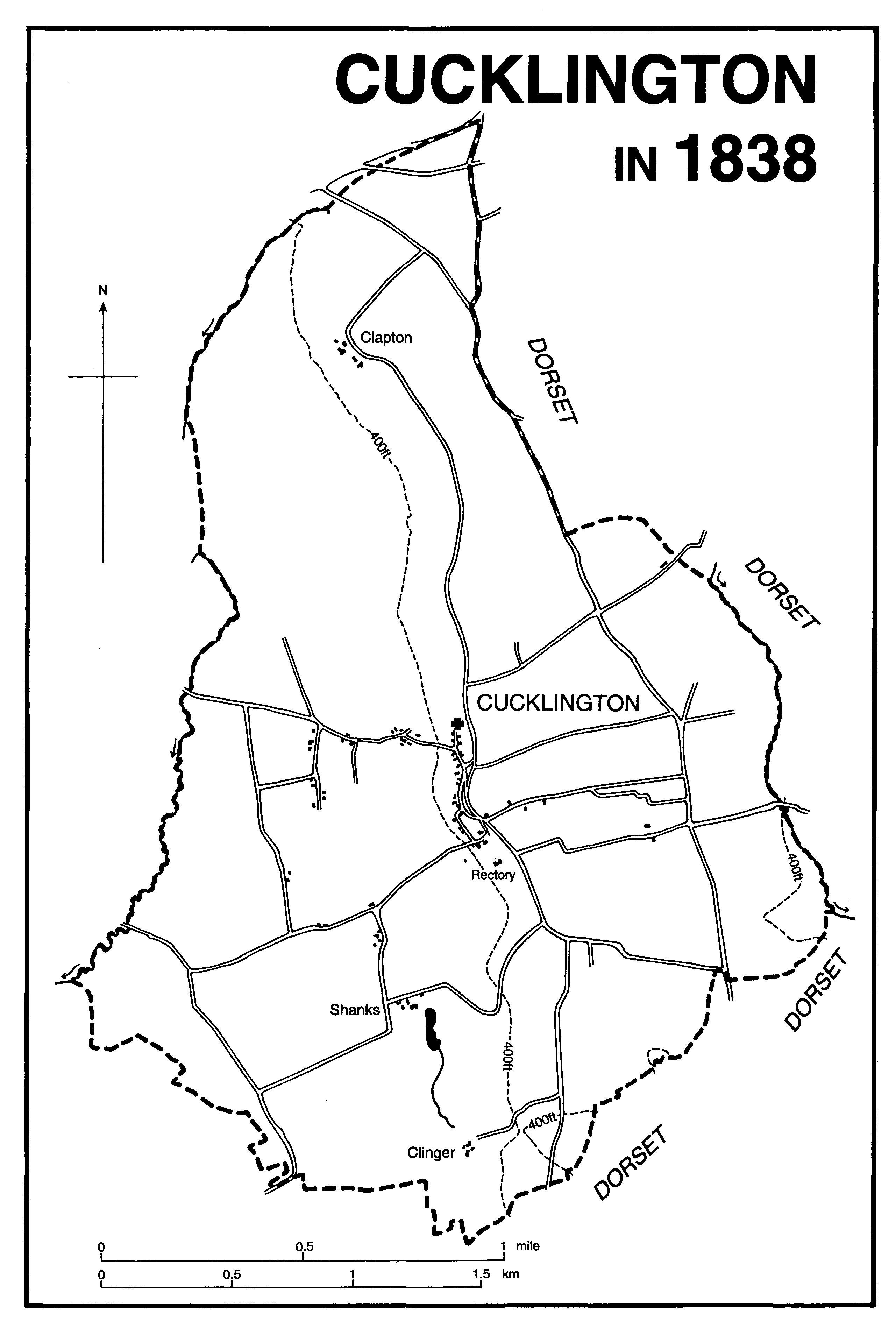
Cucklington in 1838
The road pattern was evidently governed both by topography and agriculture. One road runs north from Buckhorn Weston (Dors.), clinging to the lip of the scarp immediately above the village street, and now ends as a track at Clapton. Another, running parallel and to the east, forms part of the parish and county boundary, and incorporates part of the former turnpike road between Blandford (Dors.) and Wincanton. In the 18th century the destination of both roads northwards was Penselwood, recollecting the importance of the grazing rights in Selwood forest. Lanes between those two roads served open arable fields. To the west of the village a road divides, both branches leading to Wincanton but one directly, the other via Stoke Trister. (fn. 7)
By the later 18th century most of the houses in the parish lay along an irregular street with the parish church at its northern end. An extension of the road westwards down into the valley was known by the early 18th century as Cock Street. (fn. 8) Towards the southern end of the main street was the pound, a small pond whose source is now known as Babwell, and a tree named Bab Tree, a name thought to be derived from St. Barbara, who is depicted in 15th-century glass in the parish church. (fn. 9) Clapton had shrunk to two farmsteads by the mid 18th century, when its alternative name of Clapton Farms or Forms came into use. (fn. 10) Clinger was known as Cleyhanger in 1319 because of its position on the clay scarp in the south of the parish. (fn. 11) Shanks, in the valley below Clinger, was probably an isolated dwelling from the time of its origin, perhaps in the later Middle Ages. (fn. 12) Hale, known as Heale in 1547, seems to have originated as a group of cottages on waste ground and was in the 19th century surrounded by extensive orchards. (fn. 13) By the mid 19th century roadside cottages had been built along Topsclose Lane and at Willow Bed, and by 1871 there were others described as at Drain and Church Drain. (fn. 14) In 1923 houses were built by the local authority on the plateau east of the village. (fn. 15) Several of the houses in the parish date from the 16th or the 17th century, the oldest probably Homers Farmhouse. Church Farmhouse bears the date 1637 and Charters is of similar date.
Two common arable fields, known as north and south fields, (fn. 16) occupied the plateau in the south-east part of the parish. Some arable strips still survived in 1838. (fn. 17) There were three small areas of common meadow. In 1721 Dole meadow, described as formerly 'field ground', was marked out with bound stones, another meadow was at Heale, and a third at Bourton Gate, to half of which ten farmers made claim. (fn. 18) A large area of common land, probably meadow, lay in the south-western part of the parish beyond Shanks adjoining Marsh in Wincanton. (fn. 19)
Field names and a 20-a. wood surviving in 1838 indicate a large area of woodland in the valley north-west of the village. (fn. 20) There may have been more in the extreme north associated with Clapton. (fn. 21)
A beerhouse, later called the Rising Sun, was open in 1866 and survived until the 1950s. (fn. 22)
A revel was held on Holy Thursday in the 1780s. (fn. 23) The village friendly society held a fête, probably its last, in September 1909. (fn. 24) There was a cricket club in the 1870s, (fn. 25) a reading room was opened at the post office in 1885, and fives was played against the church tower in the later 19th century. (fn. 26) The village hall was opened in 1949. (fn. 27)
In 1801 the population totalled 358. It fell and rose in alternate decades until 1841, reached 356 in 1851, declined over the next thirty years to 269 in 1881, and after a slight rise declined further to 239 in 1901. It continued to fall and in 1981 was 162, but in 1991 was 173. (fn. 28)
Sir John Digby led a successful raid on Parliamentarians in the parish in 1645. (fn. 29)
MANORS
Leving and Swain held CUCKLINGTON in parage in 1066, and in 1086 Bretel de St. Clair held it of Robert, count of Mortain. (fn. 30) Overlordship passed to the Crown after the rebellion of William, count of Mortain, in 1106 and thereafter the manor was held in chief, in 1212 expressed as a fee Mortain but in 1345 as a member of Stoke Trister and parcel of the barony of Lorty. (fn. 31) In 1354 the manor of Wootton Fitzpaine (Dors.) was said to be held of the lord of Cucklington (fn. 32) and in 1361 some land in Chaffcombe was also said to be held of him. (fn. 33)
The land of Bretel de St. Clair evidently passed to Walter of Ashley (d. 1195), and his son and namesake, also known as (Sir) Walter of Stoke (d. 1246), held both Cucklington and Stoke Trister in 1212. (fn. 34) The two estates descended together, Cucklington described once as a hamlet (fn. 35) but usually as a manor, until 1764 or later. (fn. 36)
William Montagu died in 1319 owning ⅓ of a fee in Clinger which was held by John de St. Clair. (fn. 37) William's grandson, also William and earl of Salisbury, had ¼ fee there in 1397 (fn. 38) and Eleanor, countess of Salisbury, held it in 1415. (fn. 39)
In 1397 the heirs of William Swan held at CLINGER 1/8 fee of William Montagu, as of Shepton Montague. (fn. 40) In 1427 John Cressebien quitclaimed to Robert Salman two farms at Clinger amounting to 131 a. (fn. 41) In 1550 the manor or messuage, held of the earl of Pembroke as of Stoke Trister, was settled by Thomas Kemys on his son John. John died in 1561 and his son, also John, was his heir. (fn. 42) The estate seems to have descended in the Kemys and Watts families with Shanks and was part of the inheritance of Elizabeth Watts and her husband John Gifford. By will dated 1789 William Buckler, Gifford's nephew, settled it and other land on his two daughters for life and then on two grandsons, Thomas Buckler Lethbridge and Francis Dugdale Astley. In 1801 Lethbridge and Astley partitioned the land. (fn. 43) By 1838 it was part of the Dalton estate. (fn. 44)
The estate later known as the manor of CLAPTON may be that which was held by Wlua and his brother Alvric in parage in 1066 and by Mauger de Cartrai of the count of Mortain in 1086. (fn. 45) Like Compton Durville in South Petherton, (fn. 46) it descended to the Durville family and in 1208 Eustace de Durville granted half his land at Clapton for ½ fee Mortain to Christine, widow of Ralph Wake (I). (fn. 47) Christine and her second husband Ralph Wild also received from the prior of Bruton a virgate of land which Wigam de Ashley had given to Bruton. (fn. 48) In 1216 Christine gave all the land to Christchurch priory (Hants), (fn. 49) and the priory retained it until its dissolution in 1539. Before 1246 the land was let, and by the 14th century was occupied by the Burewell family. (fn. 50)
In 1578 it was described as the manor, capital messuage, or farm of Clopton alias Clapton, lately belonging to the monastery of Christchurch, and in that year it was settled by John Ewens (d. 1585) on his heir Alexander. (fn. 51) Alexander sold it to Robert and John Harbin in 1601. (fn. 52) John died in 1639 and was succeeded by his son Robert, on whom the farm had been settled in 1611. (fn. 53) In 1640 Robert sold it to Thomas Nicholls, who had evidently been in occupation since 1615 or earlier. (fn. 54) Thomas, or another of the same name, held the estate in 1661 and died in 1677/8. (fn. 55) The Nicholls family continued in occupation until 1717 or later. (fn. 56) By 1737 the farm and other lands had come into the hands of George Daubeney in succession to Richard Nicholls, (fn. 57) and by 1766 the estate, known as Clapton Farms, was shared between the Hon. Elizabeth Byng and John Wadman. George Byng succeeded Elizabeth in 1789 and was taxed as owner in 1794, but by 1791 Philip Pitman (d. 1797) had acquired what was called Clapton manor and Higher Clapton farm, probably from the Byngs. He had certainly bought Lower Clapton from George and Anne Byng in 1790. (fn. 58)
From Elizabeth (d. 1826), widow of Philip Pitman, the estate passed to their daughter, also Elizabeth (d. 1833), wife of Thomas Lyddon Surrage (d. c. 1863). In 1860 Surrage divided the two farms between his two sons, Thomas Lyddon and James, and the manor passed to Thomas with Higher Clapton farm. In 1869 Thomas conveyed his share to James and the whole passed on James's death in 1886 to his widow Harriet and on her death in 1904 to her only surviving son Edward J. R. Surrage. He died in 1939 and his only surviving son J. L. Surrage sold the estate in 1949 to C. J. Dowding (d. 1988). The owner in 1994 was F. J. E. Dowding. (fn. 59)
Clapton Farm was built early in the 17th century (fn. 60) and has a main range with two short rear wings. The three-room plan includes a cross passage which is entered from a porch. The principal rooms were refitted late in the 18th century and the minor rooms during the 19th when the eastern rear wing, which housed the staircase, was largely rebuilt. A walled forecourt is entered between gate piers of c. 1700 on the line of the porch.
A copyhold tenement called SHANKS was let in 1546 with just over 50 a. of land to Robert Kemys. (fn. 61) Kemys, who held freehold property in the parish by 1566, died in 1587. (fn. 62) By 1593 Shanks was described as a capital messuage and mansion, and in 1602 it was sold by Robert Kemys's son Hugh to Hugh Watts. (fn. 63) Watts died in 1625 and the estate passed in succession to his son Nicholas (d. 1649) and to his grandson Hugh (d. c. 1692–3). (fn. 64) Hugh was succeeded by his grandson Nicholas Watts, who died in 1729 leaving an only daughter Elizabeth, later wife of John Gifford. (fn. 65) Shanks passed on her death in 1747 to Nathaniel Dalton, son of Elizabeth's great aunt Mary Dalton (née Watts), and himself rector of Cucklington in succession to his father. (fn. 66)
Dalton died in 1766 and was followed by his son John (d. 1808) and his grandson Nathaniel (d. c. 1834), both clergymen. (fn. 67) Mary, only child of the last, married Robert Foster Grant, from 1826 Grant-Dalton (d. 1854). Their son Dalton Foster Grant-Dalton (d. 1890) was followed by his younger son Alan (d. 1918). Alan's son Alan Trevanion Grant-Dalton sold the estate in 1920 (fn. 68) to the tenant, Sir Arthur Sutton, Bt. (d. 1948). (fn. 69) His son Sir Richard Sutton was owner in 1949.
If any part of the house called Shanks which was described as newly constructed in 1566 (fn. 70) remains, it is within the west end of the present main house. The dining room, whose decoration is of the later 17th century, appears to have formed one end of a range which was enlarged to the west in the 17th century and had the hall built against its east side by the mid 18th century. The 18th-century work was part of an enlargement and remodelling which produced a house with a roughly symmetrical north front, centred on a two-storeyed porch leading into the hall, and having the range containing the old kitchen as one slightly-projecting wing and an east wing which contained the drawing rooms. Both wings project southwards, but on that side they are not symmetrical and between them the end of the early range and the staircase block rest in the re-entrants. The plan is irregular and reflects the phased development of the house, but the main ranges are united beneath a lowpitched hipped roof and the east front is entirely of 18th-century character, a facing of fine ashlar of five bays with a central pedimented doorcase.
Service buildings extend the west front. That to the north is 17th-century and was originally detached. The gap was filled in the 18th century and at about the same time the range containing the old kitchen was extended southwards. Several rooms are panelled in the mid-18th century style and the staircase and its plasterwork are of unusually high quality.
ECONOMIC HISTORY
In 1066 Cucklington manor gelded for 7 hides. In 1086 there was land for 6 ploughteams but the demesne of 3½ hides had only 1 team with 1 servus. The tenants' farms comprised 3½ hides with 2 teams shared between 12 villani, 8 bordars, and 4 cottars. Clapton gelded for 3 hides and there was land for 3 teams. Its demesne holding was 2 hides, farmed with 1 team and a servus. Two villani and 3 bordars farmed the remaining hide. On the two holdings together there were 14 beasts, 23 pigs, 4 unbroken mares, 229 sheep, and 47 she goats. The main estate had 22 a. of meadow; the value of both estates had fallen since 1066. Woodland measured 20 furlongs by 5 furlongs. (fn. 71)
The main estate was administered with Stoke Trister as a single manor (fn. 72) and no separate accounts or surveys survive until 1547, although autumn works at Cucklington and Clinger were separately noted in 1442–3. (fn. 73) The owner of Clapton was licensed to inclose woodland in the early 13th century, (fn. 74) and there was a warren at Clinger. (fn. 75) In 1535 predial tithes in the parish were worth more than double the tithes from wool and lambs. (fn. 76)
In 1547 the rent income from Cucklington manor totalled £18 9s. 2½d. and included 17s. 7d. from 5 free tenants and the remainder from 25 copyholds, one of which was held by a bondman (nativus). The largest holding, called Cucklington farm, comprised a sheephouse and 250 a., two thirds of which was arable; it was held at will for a rent of £8 pending agreement on a lease. In addition to paying rent a freeholder and 11 copyholders paid worksilver at Michaelmas, six of them 11s. each and the rest much smaller sums. Most copyholders also paid eggs or chickens at Easter and small quantities of wheat and oats, and were responsible for the repair of part of the park pale at Stoke Trister. The total value including the grain, chicken, and eggs was £24 16s. 0½d. (fn. 77)
By 1566 the rental income had decreased slightly to £23 14s. 9½d. but there was one additional tenant. Two tenants were still described as nativi. (fn. 78)
In 1547 there were c. 430 a. of arable equally shared between two fields, 330 a. of pasture, and c. 45 a. of meadow. (fn. 79) By 1566 c. 490 a. of arable was still shared roughly equally between two fields, but pasture seems to have decreased and meadow doubled in area. Some 40 a. of arable was described as newly inclosed and a number of exchanges had taken place. The single large farm with the sheephouse was held on a 40-year lease by 12 tenants. (fn. 80) The sheephouse and adjoining land were subsequently divided into 14 parts which were let individually or in groups with a share of Cucklington farm through the 17th and 18th centuries, each share carrying a rent of 11s. 5¼d. (fn. 81) Marl was being used by the mid 16th century. (fn. 82)
When Selwood forest was inclosed in 1627–9 at least 22 farmers in the parish lost grazing rights, including the 14 shareholders of Cucklington farm who between them had sent 23 beasts there. Several leading tenants, including Richard FitzHerbert the rector, Nicholas Watts, and Hugh Kemys, were prepared to fight the decision. (fn. 83) In the next decade consolidation of arable strips was a regular occurence. (fn. 84) Later in the century the inclosure of Horwood in Horsington extinguished the grazing rights of Cucklington farmers there, (fn. 85) leaving them entirely dependent on pasture within the parish.
After the death of Philip Herbert, earl of Pembroke, in 1650 a few small farms were sold, but 29 copyholds in the parish comprising 173 a. of arable, 143 a. of meadow, and 214 a. of pasture were conveyed to Hugh Wyndham, all subject to cash rents but six also charged with rents in wheat, oats, pullets, or a capon. Seven of them ranged in size between 30 a. and 50 a. (fn. 86) The freeholds outside the manor were much more substantial and included the rectory, Clapton, and Shanks. (fn. 87) William Knight of Hale, whose family were later both copy- and leaseholders of the manor, died in 1640 leaving property worth £1,198, more than half of which was in cash or on loan. (fn. 88)
Inclosure during the later 17th century (fn. 89) seems not to have produced immediate changes in the pattern of holdings, and farms comprised land scattered throughout the parish. (fn. 90) From the 1730s, however, tenancies were converted from copyholds and improved rents substantially increased the cash value of the Napier estate, most of which was then in Cucklington parish. By 1765 the two largest individual holdings attached to the manor were 99 a. held under three leases by John Dalton, and the 61-a. Plashbridge farm. (fn. 91) By 1783 there were five farms measuring between 60 a. and 75 a. on the Phelips estate. (fn. 92) By the same period two substantial holdings, Clinger and Upper Shanks or Dog Kennel farms, had been created on the Dalton estate based at Shanks. (fn. 93)
The farming in the parish was said c. 1785 to be poor on wet, cold clay, and no turnips were grown (fn. 94) although limekilns were in operation. (fn. 95) By 1838 consolidation of holdings had taken place. The Dalton estate in the parish comprised 485 a. shared between Church (267 a.), Clinger, and Upper Shanks farms; the two farms at Clapton totalled 405 a., and there were six other farms of between 50 a. and 100 a. (fn. 96) Dairying had become important by the early years of the century, and whole farms had for some time been under lucerne (French grass). (fn. 97) By 1851 Clinger farm had increased in size to 300 a. and Babwell and Thorns farms were so named. (fn. 98) In 1871 the combined Clapton farms measured 422 a., Church farm 315 a., and Clinger farm 208 a. (fn. 99) Prominent among the tenant farmers were the brothers Thomas and Charles Dowding, in 1861 of Clinger and Church farms respectively. (fn. 100) Their father and another brother were tenants in Stoke Trister. (fn. 101) From the 1860s to 1883 or later a butter factor was in business. (fn. 102) In 1905 there were 1,259 a. of permanent grass and 349 a. of arable, little changed from sixty years earlier. (fn. 103) In 1988 468 ha. was under grass and 125 ha. was arable, mostly winter barley or wheat. There were 16 holdings of which two were entirely dairy farms and one was mainly so, and one specialised in cattle rearing. (fn. 104) The largest holding was the Clapton Manor estate, which in 1940 had measured over 400 a. in the parish and small acreages in Stoke and Penselwood. (fn. 105)
In 1707 and 1745 linen weavers were living in the parish, (fn. 106) and Joseph Knight (d. 1759) of Hale seems to have been both a blacksmith and cider producer as well as a dairy farmer. (fn. 107) There was at least one shop in the village by 1814, (fn. 108) and in 1851 at least 12 craftsmen were associated with farming. (fn. 109) There were two shops by 1875 (fn. 110) but only one in 1897. (fn. 111) In 1939 there was still one shop, a carpenter, and a blacksmith. (fn. 112)
Market and fair
In 1304 Henry Lorty was licensed to hold a weekly market every Tuesday and a fair for ten days from the eve of All Saints (31 Oct.). (fn. 113) No income was recorded in accounts of 1442–3 or later. (fn. 114) A fair was said in 1861 to be held on Ascension day. (fn. 115)
LOCAL GOVERNMENT
By the mid 14th century Cucklington was part of a single tithing which also included Stoke Trister and Bayford. (fn. 116) Cucklington tenants attended the manor court at Stoke in the mid 16th century (fn. 117) and probably earlier, and continued to do so in the later 17th century. (fn. 118) Court business in 1633 included granting licences for Cucklington tenants to exchange arable strips to consolidate their holdings. (fn. 119) By the early 18th century courts leet with view of frankpledge and courts baron were held at Cucklington in October each year for business from both Cucklington and Stoke. In 1716 all people above 12 years of age were summoned for 10 o'clock in the morning. Presentments or rolls survive for 1708, 1712–16, 1755–8, 1760, and 1762–4. (fn. 120) Much of the business involved the maintenance of roads, bridges, and hedges, but in 1713 the jury asked for stocks and a whipping post to be set up at Cucklington, and in 1715 ordered the pound to be mended. In 1712 a hayward was appointed for Cucklington alone. In 1785 the lord of the manor paid for a new pound in the village. (fn. 121)
By the end of the 17th century the parish was administered by two churchwardens and two overseers for the poor, (fn. 122) but no records have survived. By 1783 the parish rented a poorhouse from the manor and also held a cottage for the poor. (fn. 123) In 1838 the poorhouse and two cottages were held by the parish. (fn. 124) The poorhouse stood on the west side of the path at the southern entrance to the churchyard and in 1993 was known as Church House. It may originally have been a church house.
The parish became part of the Wincanton poor law union in 1835, the Wincanton rural district in 1894, and the Yeovil (later South Somerset) district in 1974. (fn. 125)
CHURCH
There was a church at Cucklington in 1264. (fn. 126) The living was a sole rectory until 1767 when it was united with that of Stoke Trister. (fn. 127) In 1980 the combined rectory was united with Charlton Musgrove. (fn. 128)
The patronage descended with the lordship of the manor until c. 1953 when Cdr. Harry Phelips transferred it to the bishop of Bath and Wells. (fn. 129) Peter de Montfort presented to the living in 1264, presumably by Crown grant, (fn. 130) the feoffees of John, Lord Arundel, in 1420, (fn. 131) and John Sydenham in 1442. (fn. 132) John Lumley, Baron Lumley, who presented in 1558, was husband of Jane, the earl of Arundel's heir. (fn. 133)
The living was valued at £6 13s. 4d. in 1291 (fn. 134) and at £12 19s. 4d. net in 1535. (fn. 135) Its reputed value was £100 c. 1670 (fn. 136) and the net value of the united rectory c. 1830 was £609. (fn. 137) In 1535 tithes and offerings were reckoned at £11 6s. 8d.; (fn. 138) in 1765 they were let by composition for £75 4s. 2d. (fn. 139) The tithes of the united rectory were commuted for £632 in 1838. (fn. 140) Glebe was assessed at £2 in 1535. (fn. 141) In 1566 it comprised 56 a. and was worth with common grazing £20. (fn. 142) There was 72 a. in 1600 and just over 78 a. in 1634. (fn. 143) The total was reduced by 7 a. in an exchange in 1821 (fn. 144) and in 1838 there was just over 97 a. for the united benefice. (fn. 145) By 1927 the total had been reduced to c. 24 a., and more was sold in 1952. (fn. 146)
The glebe house was reported to be in decay in 1568 (fn. 147) and in 1816 it was 'scarcely dry enough to be inhabited with safety' and was about to be vacated. (fn. 148) That was the building, evidently of the 18th century, which c. 1825 became the service wing to a new villa which was built against its south end. About 1947 the house was sold and became a private dwelling, in 1992 known as Cucklington House and in 1994 as Aislaby. Since 1990 the house has been remodelled and a large conservatory and terrace, which partly cover a swimming pool, have been added to the south. To the north there are a game larder and former bakehouse and, beyond a walled kitchen garden, the 19th-century village schoolroom and a stable.
In 1946 the house known as Greenhill became the benefice house; it was sold in 1980 when the incumbent of the living moved to Charlton Musgrove and became known as the Old Rectory. (fn. 149)
At least four rectors in the 14th century were appointed when only acolytes and one, Robert Hildebrand, was for several years away from the parish in the service of the lady of the manor. (fn. 150) There was a parochial chaplain in 1463. (fn. 151) Thomas Been, rector 1466–8, was at the same time priest vicar at Wells cathedral. (fn. 152) Rectors were not resident from c. 1563 until 1581. (fn. 153) Richard Fitzherbert, rector from 1607, was also rector of Stoke Trister, archdeacon of Dorset from 1621 and incumbent of Cheselbourne (Dors.) from 1639 when he resigned Stoke. He was replaced c. 1645 but continued to live in Cucklington and was 'often plundered and imprisoned'. He died c. 1653. (fn. 154) William Ashley, rector 1662–74, also held Penselwood but lived at Cucklington. (fn. 155) Three members of the Dalton family held the rectory successively between 1674 and 1766. (fn. 156) There were some 30 communicants c. 1788. (fn. 157) From 1779 seven members of the Phelips family were resident rectors for over 130 years. (fn. 158)
Until the 1850s or later there was one Sunday service, alternately morning and afternoon; the average attendance in 1851 was 120 in the morning, equally divided between children and adults, and in the afternoon 140 adults and 60 children. (fn. 159) There were two Sunday services and monthly celebrations of communion in 1870. (fn. 160)
The church of ST. LAWRENCE, so dedicated by 1468, (fn. 161) is built of rubble with ashlar dressings and comprises a chancel with north chapel and a nave with north aisle, south chapel, and south tower above a porch. The renewed triple-lancet east window is 13th-century and the chancel south window is 14th-century. The two-bayed north arcade is early 14th-century but the aisle appears to have been rebuilt in the 15th century when the north chapel was added at its eastern end. The porch and tower were built at about that time and the south chapel, which fills the angle between the nave and the porch, early in the 16th century. A tablet of 1703 on the tower suggests a major rebuilding or restoration and the tower roof cupola was probably added then. Extensive restoration work was carried out in 1880 (fn. 162) under the direction of G. R. Crickmay who replaced the single arch to the south chapel with a triptych, pierced the wall between the north chapel and the chancel, moved the organ there from a west gallery, and reset the chancel screen in the north aisle. The roofs of the nave and chancel are of that restoration; those of the aisle and south chapel may be 18th-century.
In the 1780s there was a singers' gallery with a wainscoted front. (fn. 163) The carved panels in the pulpit (1880) and the reredos (1898) are by Vermeylen of Louvain; the ends of the choir stalls were carved by Miss C. Phelips to designs by Crickmay. (fn. 164) The glass in the east window of the chancel is by Clayton and Bell of 1874. (fn. 165)
There are six bells, the three heaviest by William Cockey probably all of 1726, and the 2nd and 3rd of 1823 by Edward Cockey. (fn. 166) The plate includes a cup of 1572 by 'I.P.', a flagon and salver of 1754 and a flagon of 1767, the work of William and James Priest and possibly of William Grundy. (fn. 167) The registers begin in 1558 and are almost complete. (fn. 168)
NONCONFORMITY
There was a Catholic recusant in the parish between 1592 and 1596 and in 1606. (fn. 169) In 1807 a house was licensed for use by Methodists. (fn. 170)
EDUCATION
There was a school by 1722 when Thomas Knight gave an endowment to teach two poor children. (fn. 171) Four children were taught there by 1818 when the mistress also kept a Sunday school for ten children. There were also three other schools with about eight children each who were taught at their parents' expense. (fn. 172) As many as 42 children were taught in 1825–6. (fn. 173) In 1833 there were 62 children at a single day school and 66 children at a Sunday school. Two children were supported by Thomas Knight's endowment, 14 others by Lord and Lady Weymouth and the rector, and the rest by parents. (fn. 174) By 1847 there were two schools, both evidently held on weekdays and Sundays, with 68 children. (fn. 175) In 1857 a schoolroom was built on glebe land near the rectory house. (fn. 176) There were 48 children on the books in 1903. (fn. 177) From 1927 the school took juniors and infants only and average attendance in 1938 was 19. The school closed in 1948 (fn. 178) and ownership reverted to the rectorial estate.
CHARITIES FOR THE POOR
Three sums totalling £140 by 1751 were invested in 1758 and in 1824 provided interest of £7 distributed by the churchwardens on St. Thomas's day (26 Dec.) each year. (fn. 179) Those sums may be the origin of the Second Poor Charity which in 1965 was invested to produce an income of £4 6s. and in 1979 £5.52p.
Hugh Wyndham by will of 1684 charged the manors of Cucklington, Stoke, and Bayford with sums for the benefit of several parishes, among them 10s. for twenty of the poorest in Cucklington at Christmas. It seems likely that the charge has not recently been paid. (fn. 180)