A History of the County of Essex: Volume 9, the Borough of Colchester. Originally published by Victoria County History, London, 1994.
This free content was digitised by double rekeying. All rights reserved.
'Iron-Age and Roman Colchester ', in A History of the County of Essex: Volume 9, the Borough of Colchester, (London, 1994) pp. 2-18. British History Online https://www.british-history.ac.uk/vch/essex/vol9/pp2-18 [accessed 19 April 2024]
In this section
LATE IRON - AGE AND ROMAN COLCHESTER
The Iron-Age Fortress
Camulodunum was the Romanized form of the British name Camulodunon, meaning 'fortress of Camulos', the Celtic war-god. (fn. 1) At the time of the Roman conquest of 43 A.D. it was the principal centre of the Trinovantes, a tribe thought to have occupied an area roughly corresponding to Essex and south Suffolk. (fn. 2) The tribe first appears in the written record in 54 B.C. when Mandubracius, a young Trinovantian prince, fled to Julius Caesar for help after his father was killed by Cassivellaunus, king probably of the neighbouring Catuvellauni. After Caesar's defeat of Cassivellaunus, Mandubracius was allowed to return presumably to become king. (fn. 3)
According to the accepted history of Camulodunum during the earlier 1st century A.D., (fn. 4) Tasciovanus became king of the Catuvellauni c. 20 B.C.; he used the mint mark ver (with variations) for Verulamium (St. Albans) and his coins circulated in an area centred on modern Hertfordshire. Two of his neighbours, Addedomaros of the Trinovantes and Dubnovellaunus of Kent, also issued coins, Addedomaros apparently in the Colne valley if not at Colchester. About 17 B.C. Tasciovanus struck some coins with the mint mark cam showing that he had gained control of Camulodunum. Soon afterwards Addedomaros held sway at Colchester for c. 10 years until he was replaced by Dubnovellaunus who himself was driven out of Camulodunum c. 5-10 A.D. by Cunobelin, a son but not the successor of Tasciovanus. Cunobelin quickly expanded his newly made kingdom by acquiring Verulamium and its territory, and by c. 25 A.D. he had annexed Kent. In 40 A.D. Cunobelin expelled one of his sons, Adminius, who appealed to the Roman emperor Caligula for help. By 42 A.D. Cunobelin was dead and in the following year the Romans invaded under Aulus Plautius. Cunobelin's sons Caratacus and Togodumnus were defeated and Togodumnus died. The climax of the campaign was the emperor Claudius's entry into Camulodunum at the head of his army.
Much of that history is now the subject of debate. Opinions differ on the significance of the distribution of coinage, and the relative chronology has also been challenged. It has been argued that Addedomaros and Dubnovellaunus both held Camulodunum before Tasciovanus, and even that there were two contemporary leaders called Dubnovellaunus, one in Essex and the other in Kent. It has also been suggested that the late coins of Tasciovanus overlapped the earliest of Cunobelin. Various dates have been proposed for Addedomaros, Dubnovellaunus, and Tasciovanus, the most radical being 40-30 B.C., 30-25 B.C., and 25-10 B.C. respectively. It has also been argued that to attempt to ascribe precise dates at all is misleading, and that the arrival of Cunobelin at Camulodunum, for example, should be dated not c. 5-10 A.D., but simply to the early 1st century A.D. (fn. 5)
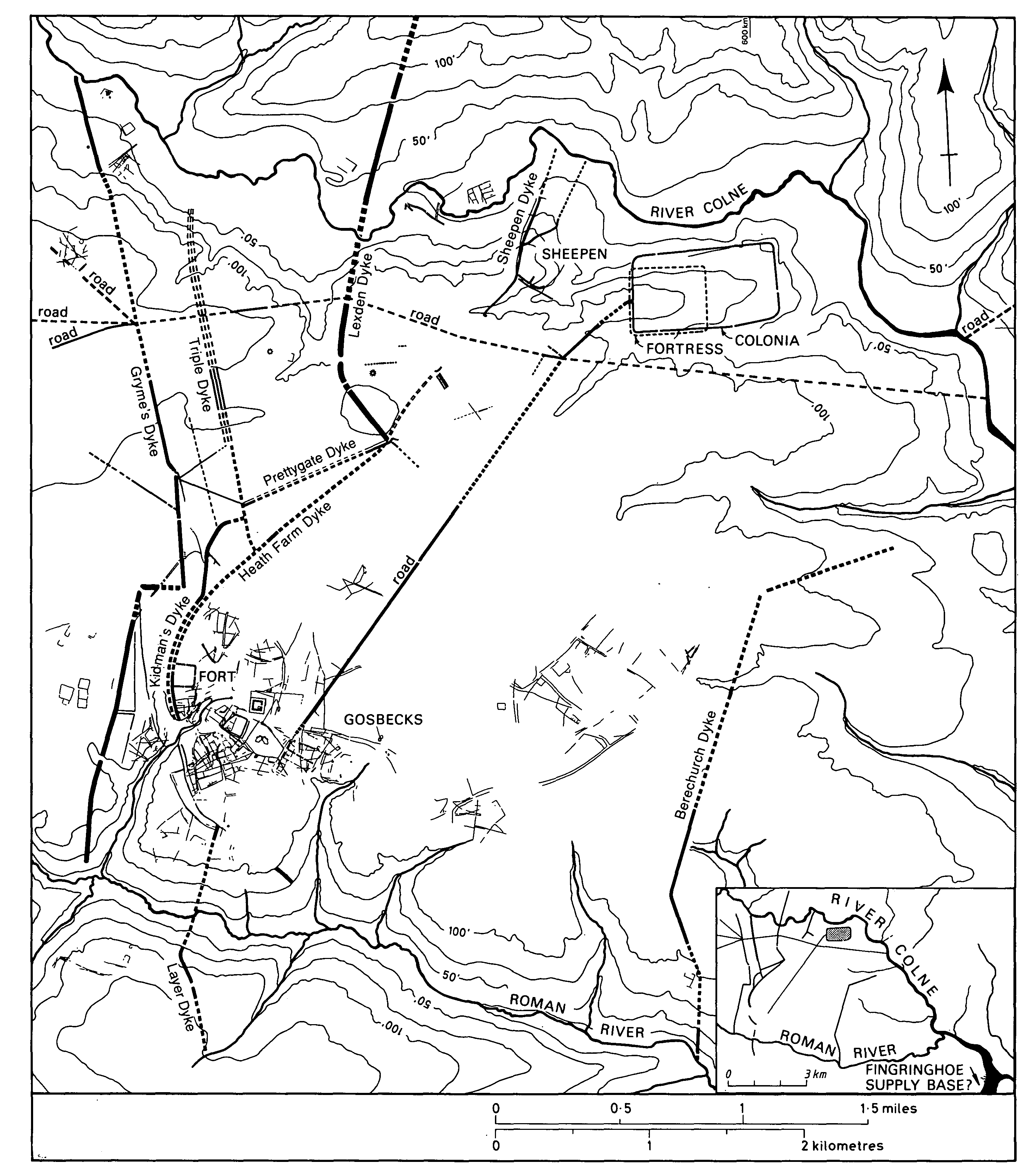
The name Camulodunum, abbreviated cam, first occurs on rare coins of Tasciovanus of the late 1st century B.C. (fn. 6) The date corresponds approximately to the earliest available archaeological evidence for the settlement which thus may not have been the centre from which the Trinovantes struck their first coins, and indeed may not have existed when Caesar invaded the country in 54 B.C. Most of Camulodunum lay on a block of land bounded on the north by the river Colne and on the south by Roman River. It was protected by a series of earth dykes 24 km. (15 miles) long. The system is the largest of its kind and date known in Britain and is testimony to the considerable importance of Camulodunum in late Iron-Age Britain. The settlement was turned into a stronghold by a careful combination of man-made earthworks and natural features such as valleys, rivers, and dense woodland. The plan of the dyke system points to a long sequence of unstructured development. There is unlikely to have been any long-term master plan, but instead each new dyke seems to have been added to provide some specific enhancement to the existing system. The complexity and scale of the system suggests that it was not just an extravagant proclamation of status but was a defensive arrangement which was repeatedly needed and frequently upgraded. Clearly the appearance of Cunobelin at Camulodunum did not mark the start of a long period of stability in the area.
Most of the dykes consisted of a V-shaped ditch and a bank formed from the upcast. There was no berm between the ditch and the bank and there is little evidence for any timber structures such as palisades, revetments, or gates. The depth of the ditches varied from dyke to dyke, from c. 5 ft. to c. 13 ft., with banks in proportion up to c. 10 ft. high. Thus the dykes provided barriers up to 25 ft. high which would have been especially effective against chariots. Most dykes faced west to provide protection from attack from that direction. Prettygate Dyke had a ditch to either side of its bank, and Triple Dyke consisted of three small dykes side by side. Most of the dykes run transversely valley to valley (north to south) to provide sequential lines of defence but a few were placed laterally (some U-shaped in section) so that they provided barriers between the entrances of some of the transverse dykes. Such variations and oddities were probably designed to control the movement of the chariots, and to a lesser extent of the mounted warriors, of defenders and aggressors alike. At places where the rivers could easily be crossed the dykes seem to have been continued beyond the Colne and Roman River, to prevent an opponent from circumventing the lines of north-south dykes.
The earliest part of the system (fn. 7) is Heath Farm Dyke which protected the Gosbecks area; the latest seems to have been Gryme's Dyke which, if not post-Boudican, was certainly post-conquest. (fn. 8) The appearance of the name Cam[ulodunum] 'fortress of Camulos' on the late 1st-century B.C. coins of Tasciovanus suggests that some dykes had been constructed by that date. It has been suggested that the construction of each major phase of the earthworks was linked to changes in the size and position of the defended area, (fn. 9) but there is no evidence for the demolition of any dykes, apart from the late destruction of Sheepen Dyke. Nor is it likely that Gosbecks was ever outside the system.
Farming was concentrated at Gosbecks and in the fertile lands along the northern edge of the Roman River valley, while the industrial and commercial centre was the riverside site of Sheepen. Much agricultural and industrial produce was imported and exported along the Colne, and in its heyday Camulodunum served a great hinterland north of the Thames, encompassing the Trinovantian and neighbouring Catuvellaunian territories and beyond. All that could have been achieved through large, regular markets where much of the region's produce was exchanged. The closely connected activities of providing such markets and striking money presumably underpinned Cunobelin's economic success.
Camulodunum, showing Roman roads and the legionary fortress
Two distinct periods of occupation or activity can be detected at Gosbecks. (fn. 10) The area was at first given over mainly to native farming, but later, presumably some time after the Boudican revolt of 60-1 A.D., the site became an important tribal sanctuary with a temple (fn. 11) and a theatre. (fn. 12) The temple stood inside a square ditched enclosure which was probably laid out in the late Iron Age as an important cultural site. Against the inside of the innermost dyke was a small Roman fort of the conquest period, (fn. 13) sited to police the area while causing minimal disturbance to its layout. Gosbecks was probably the site of a pre-Roman market and the Roman authorities were probably keen to maintain such a major regional market for its economic benefits. The frequent association in antiquity of markets and religious sites explains the presence of the temple, and of the large bronze statuette of Mercury, the Roman god of merchandise, found at Gosbecks. (fn. 14)
The heart and earliest part of the Gosbecks site was an exceptionally large native farmstead, the main buildings of which stood in a large trapezoidal enclosure which on analogy with similar sites elsewhere probably contained round houses. Complicated multi-period systems of trackways, ditched fields, and defensive dykes all lead to the main enclosure and possibly represent a century or more of development. The main enclosure was remodelled several times. In its first phase, the enclosing ditch was over 10 ft. deep and clearly defensive. Without excavation it is not possible to determine the relationship between the defended farmstead and the earliest of the dykes, but it cannot be assumed that the defences around the farmstead predate the earliest dykes.
Sheepen provided a manufacturing and trading base, first for the Iron-Age settlement, then for the Roman fortress, and finally for the pre-Boudican town. Despite its industrial nature, finds from Sheepen are extraordinarily plentiful and of high quality, particularly when compared with the material recovered from the earliest levels in the town centre. Products from Sheepen (fn. 15) in the pre-conquest period included moulds generally thought to have been for the production of coin blanks. (fn. 16) After the Boudican revolt the site became a native sanctuary with the construction of at least four temples. (fn. 17) The pattern of change is reminiscent of Gosbecks and prompts the question whether Sheepen too was a market site. Such a market may have catered for manufactured goods rather than livestock and agricultural produce, which could have been the primary concern of Gosbecks.
Most of the late Iron-Age burials have been found at Lexden, between Sheepen and Gosbecks, the most important being the Lexden tumulus. (fn. 18) The remarkable collection of grave goods, dated to c. 15-10 B.C., (fn. 19) included figurines of a boar and a bull, a candelabrum, at least 17 amphoras, chain mail with a leather undergarment, thread-like gold strips, and a silver medallion of the head of Augustus. They were accompanied by a small amount of cremated human bone and were mostly on or near the floor of a deep pit under the barrow mound. Some of the objects had been deliberately broken at the time of the cremation and the grave pit seems to have contained a square wooden chamber. (fn. 20) Although remarkable, the surviving grave goods provide only a very incomplete picture of a quite exceptional group which may have included various pieces of furniture such as a couch or a litter, a large wooden chest and a folding stool, vessels such as a bronze bowl and a bronze jug, and items incorporating silver- and gold-embedded textiles. The size of the group, the richness of the objects in it, and the rarity of the burial rite suggest a king's burial. The medallion of Augustus may be of great significance since heads based on that of Augustus appear on some of the more Romanized Celtic coins of the period. (fn. 21) The numismatic evidence as presently understood is of limited help in identifying the person buried, although Addedomaros is an obvious candidate.
About 200 m. north-west of the tumulus was a flat cremation cemetery which over a period of years has yielded c. 30 vessels from at least 9 burials. The material is typically mid 1st-century B.C. to early 1st-century A.D., but the absence of any Gallo-Belgic pottery suggests that the burials predate the Lexden tumulus by up to 30 years. The group thus provides the earliest available evidence for occupation at Camulodunum. (fn. 22)
Members of the native aristocracy were buried in wooden chambers at a special funerary site at Stanway, a short distance west of Gosbecks. (fn. 23) Each of the chambers had been placed symmetrically in large, roughly square, ditched enclosures up to 80 m. across. There were five enclosures in two rows. Each of the chambers was as large as a small room and contained the remains of a rich collection of grave goods which had been ritually smashed and scattered throughout the backfill of the chamber. Cremated human remains were also sprinkled throughout the backfill, and a least one of the chambers seems to have been broken up as part of the ritual. Near the largest of the chambers were two secondary graves, both made c. 10 years after the Roman invasion. Grave goods in the richer of them included over 20 vessels of pottery, metal, and glass, a set of glass gaming counters, a possible gaming board, a spear, and probably a shield.
Although the grave assemblages were not as rich and varied as that in the Lexden tumulus, the people with whom they were buried were of high status and presumably related to each other by marriage or birth. The largest chamber dated to c. 30 A.D., when Cunobelin was in power, was probably the grave of one of his relatives. The latest chamber dates to c. 60 A.D. or later and was presumably for a woman since it contained beads from a broken necklace. She may have been a daughter or a niece, or perhaps a daughter-in-law, of Cunobelin. Such a burial after the Roman conquest indicates something about the relationship between the Romans and at least one element of the local aristocratic class. Not only did the British nobles buried at Stanway see no moral dilemma in using Roman or Romanized 'consumer goods' but they were allowed to live alongside the Roman colony with sufficient freedom to continue their own customs. The secondary grave with the arms appears to be the burial place of someone who enjoyed a particularly favoured status with the Roman authorities. It may be that after conquering Camulodunum Claudius installed a pro-Roman Briton such as Adminius as the native leader, and that the latest chamber was for a member of a pro-Roman faction of which Adminius was or had been the key person.
Camulodunum, or at least its immediate environs, was densely inhabited; the presence after the conquest of the fortress and the Gosbecks fort implies a large indigenous population in the vicinity and so too does the scale of the native defences and the large investment of man-hours which their construction represents. Yet the focus of the settlement was the comparatively small trapezoidal enclosure at Gosbecks to which the trackway systems led. The convergence suggests that within the enclosure were the houses of the successive native kings and that Camulodunum was in essence a large royal estate, which, by developing its role as a port and regional market place, provided its owners with far-reaching political and economic power. (fn. 24)
That interpretation is supported by the use of the site as a sanctuary in the Roman period. The locating of a theatre and temple beside the trapezoidal enclosure can be no accident and suggests that the latter was a place of great cultural significance for the Britons. The site of the trapezoidal enclosure appears to have been retained in the Roman period and its defensive ditch replaced with a more modest boundary. The architectural styles of the major buildings reflect native taste, and thus presumably some degree of native control of the site. The theatre is not an orthodox type, (fn. 25) unlike the more classical theatre in the colony, (fn. 26) and the temple in its square-ditched enclosure is not of a purely Graeco-Roman style like the great temple of Claudius in the colony but is of the Romano-Celtic type. In the light of the excavations at Stanway, it is conceivable that Gosbecks in the post-conquest period was more than a sanctuary on a site of great historical significance to the native population, and that Cunobelin was buried within the square-ditched enclosure.
The Legionary Fortress
Shortly after Claudius's entry into Camulodunum the army consolidated its gains with the construction of a legionary fortress. The new base (fn. 27) was carefully sited: inside the defences of the native settlement, but on unoccupied land so as to cause as little disruption as possible; near the river to take advantage of waterborne transport and yet sufficiently high to command a good view of the surrounding area; guarding the main river crossings into the oppidum; close to a good supply of water. The site which met all the requirements was a spur of land immediately downstream from Sheepen, and work began there c. 44 A.D. The longitudinal axis of the fortress was placed on an east-west ridge formed by the steep slope down to the river Colne on the north and the more gentle slope to the south. The fortress was aligned on true north and its east and principal gate (porta praetoria) faced seaward. On the east was a large annexe, the precise size and position of which have not been established but which is assumed to have been about a third the size of the original fortress. The fortress may have been preceded by a much smaller unfinished Roman military base whose existence is suggested by a deep preBoudican north-south ditch and an early east-west rampart about 175 m. (190 yd.) east of the ditch. (fn. 28)
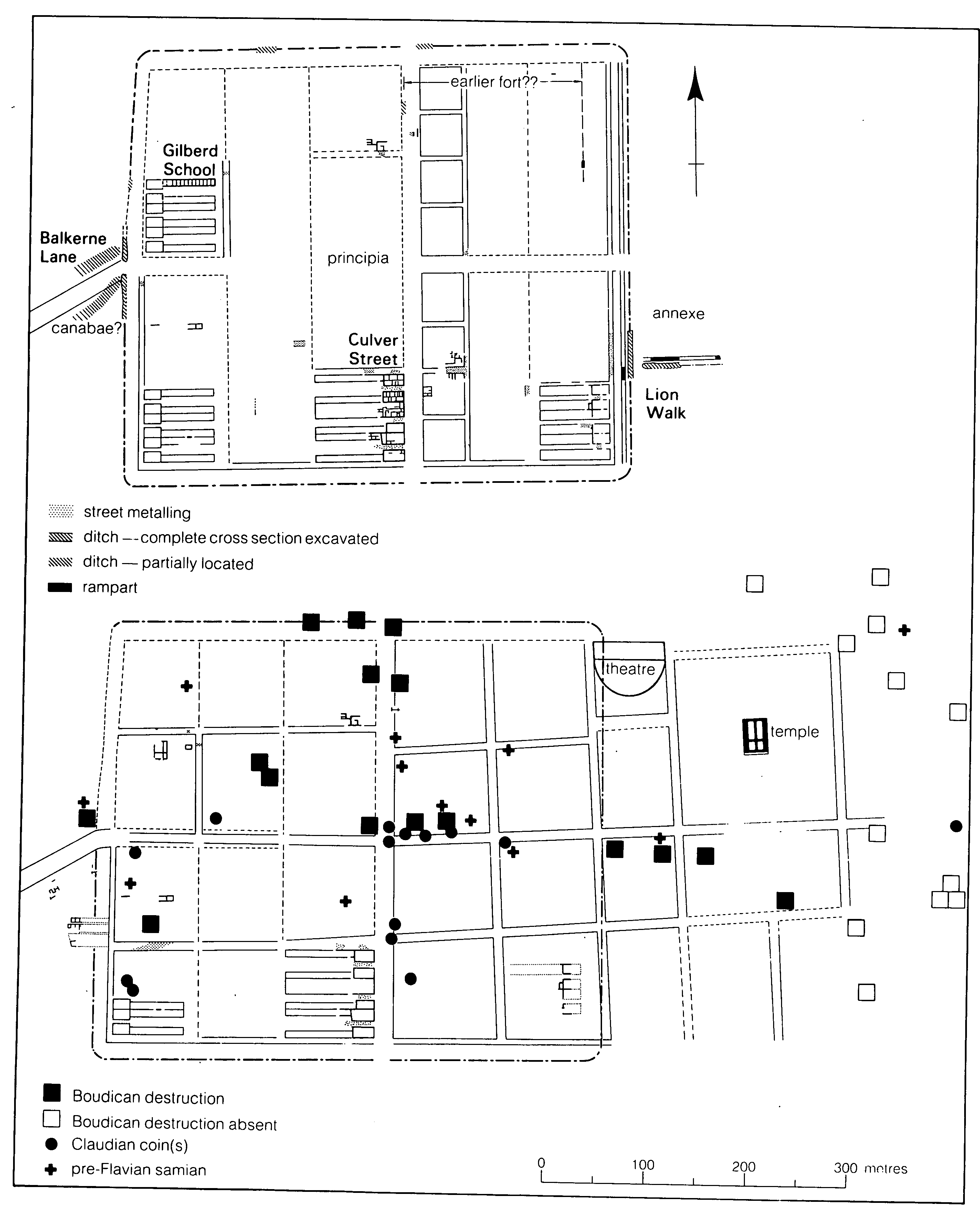
The legionary fortress (top) and the per-Boundcan colony (bottom)
The layout of the fortress has been established clearly enough to show that the plan of the streets determined the plan and shape of the buildings. The plan was formulated mainly in terms of multiples of 100 Roman feet (pedes monetales). (fn. 29)
The defences of the fortress and its annexe were of identical construction. The ditch was V-shaped in profile and c. 2.5 m. (8 ft.) deep and c. 5 m. (16 ft. 6 in.) wide. The rampart was made of sand revetted with vertical faces of coursed blocks of sun-dried sandy clay. The annexe rampart seems to have been slightly wider than that of the fortress proper, 3.8 m. (12 ft. 6 in.) as opposed to 4.1 m. (13 ft. 6 in.). In each case, the topsoil was removed and the rampart built over a layer of timbers laid across its full width. There was a berm at least 1.8 m. (5 ft. 11 in.) wide between the rampart and the ditch. The street around the inside of the defences (via sagularis) was set back 9 m. (29 ft. 6 in.) from the inner face of the rampart. No via sagularis has been recognized in the annexe. (fn. 30) Nothing is known of the fortress gates except their locations.
Few of the buildings in the fortress have been examined, and of those none have been more than half uncovered. There were presumably at least 60 barracks - more if an auxiliary unit was garrisoned with the legion - and stables for the horses of the cavalry unit. Other buildings presumably included stores, workshops, latrines, a hospital, a headquarters building (principia) in the centre of the fortress, and the legionary commander's house (praetorium).
Each barrack was at least 69 m. (227 ft.) long and accommodated a 'century' of soldiers. About one third of each barrack was occupied by the centurion and took the form of a semidetached block at the end of the barrack on either the via principalis or the via sagularis. Some of the rooms were heated with hearths placed against a wall. (fn. 31) The floors, usually of sand or sandy clay, were rudimentary, except in one centurion's quarters where at least two were of planks. (fn. 32)
Apart from the barracks, the only known buildings in the fortress are two large ones which fronted on the east side of the via principalis. (fn. 33) They were presumably two of the eight large buildings which normally took up the entire length of one side of that street in Roman fortresses. Six of those buildings are usually thought to have been occupied by tribunes (a class of officer) so one, if not both, of the two known Colchester buildings is likely to have been so used. The southern building, however, had in its northern range of rooms a series of hearths and shallow burnt pits used for working in brass which suggest that it may have been a workshop.
The annexe was probably used for stores and, more important, may have contained the large set of baths needed for the comfort of the soldiers. Any legionary baths were almost certainly kept for civilian use in the new colony, but their site has not been found.
The buildings of the fortress were soundly made, using several different construction techniques. The load-bearing walls of the barracks had three main structural components: a mortar and stone plinth, a pair of oak ground-plates, and a superstructure of coursed sandy-clay blocks. Most of the internal walls consisted of a timber frame, the ground-plate bedded directly on top of the natural sand and the panels between the uprights filled with wattle and daub or sandy-clay blocks. (fn. 34) In contrast, at least three of the large buildings on the east side of the via principalis were built in a manner normally associated with the Roman army. Trenches were dug up to 1 m. deep along the lines of the intended walls. Substantial posts of roughly square section were then dropped into the trenches as they were backfilled. The gaps between the posts were filled with daub blocks and the finished walls left unplastered. (fn. 35) The walls of buildings outside the base were formed much more simply, by applying sandy clay as a daub to a frame made by hammering a row of stakes into the ground and then weaving wattles round them. (fn. 36)
The streets of the fortress, like those of the later Roman town, were made of packed gravel. Metalling the streets was not a priority in the fortress, and some streets between barracks were left unmetalled. In one place wheel ruts and a hoof print of an ox, cow, or bull were impressed in sandy soil underlying the earliest metalling. (fn. 37)
In addition to the fortress the army built a small fort, known only from crop marks, at Gosbecks. It covers c. 1.6 ha. (4 a.) inside its ramparts, implying a garrison of cohort size (about 500 men). (fn. 38) There may have been another small fort at a landing area further downstream at Fingringhoe where Roman military equipment and substantial quantities of pottery and coins have been found. (fn. 39)
Two early tombstones indicate the likely garrison. One was erected in honour of Marcus Favonius Facilis, (fn. 40) a centurion with Legio xx, who is not said to have been a veteran and so was presumably a serving soldier when he died. The other was to Longinus Sdapeze, (fn. 41) an officer of the 1st squadron of the Thracian cavalry unit, who had served only 15 years and is also likely to have been in the army at the time of his death. Both stones stood by the side of the main street leading into the town. Longinus may have been stationed at the fort at Gosbecks or have been part of a unit attached to the legion and based in the fortress. The monuments are not, however, unequivocal evidence that the units were stationed at Colchester. Either man could have died while on temporary duty there during the early years of the colony (fn. 42) or while part of a small garrison based in the colony in the 50s A.D.: Tacitus recorded just such a unit at Colchester at the time of the Boudican revolt. (fn. 43)
Large numbers of copper-alloy coins were struck at unidentified mints in the north-western provinces of the Roman Empire as imitations of Claudian aes produced in Rome between 41 and 54 A.D. Since Colchester is the most prolific site in Britain for such coins it has been suggested that it had a mint at that time. (fn. 44)
The Roman Colony
The name of the Roman town is uncertain. A 2nd-century inscription refers to 'colonia Victricensis which is at Camulodunum', (fn. 45) making a clear distinction between the Roman colony and the Iron-Age fortress. It has been suggested that originally the official name was colonia Claudia and that the colony was renamed colonia Victricensis when it was refounded after its destruction during the Boudican revolt. (fn. 46) Later the town seems to have become known simply as Colonia. (fn. 47)
The Roman colony was founded c. 49 A.D. after the legion had been withdrawn.
The buildings in the fortress had been well constructed and intended to last, so it is not surprising that the decision was made not to demolish the fortress when it was no longer needed by the army but to convert it into a town. (fn. 48) The process involved considerable building work. The legionary defences were dismantled and a new street grid laid out at a slightly different angle on the site of the annexe. The via principalis and the north-south street to the west were retained. The via sagularis was also kept, except on the east side of the colony where it was replaced by a new street built over the levelled legionary defences. About two thirds of the c. 18 military buildings so far excavated were burnt in the revolt of 60-1 A.D. That, combined with the number of re-used streets, suggests that a substantial proportion of the military buildings survived the transition from fortress to town. Nevertheless, the laying out of the east-west streets at the foundation of the colony necessitated the demolition of many buildings.
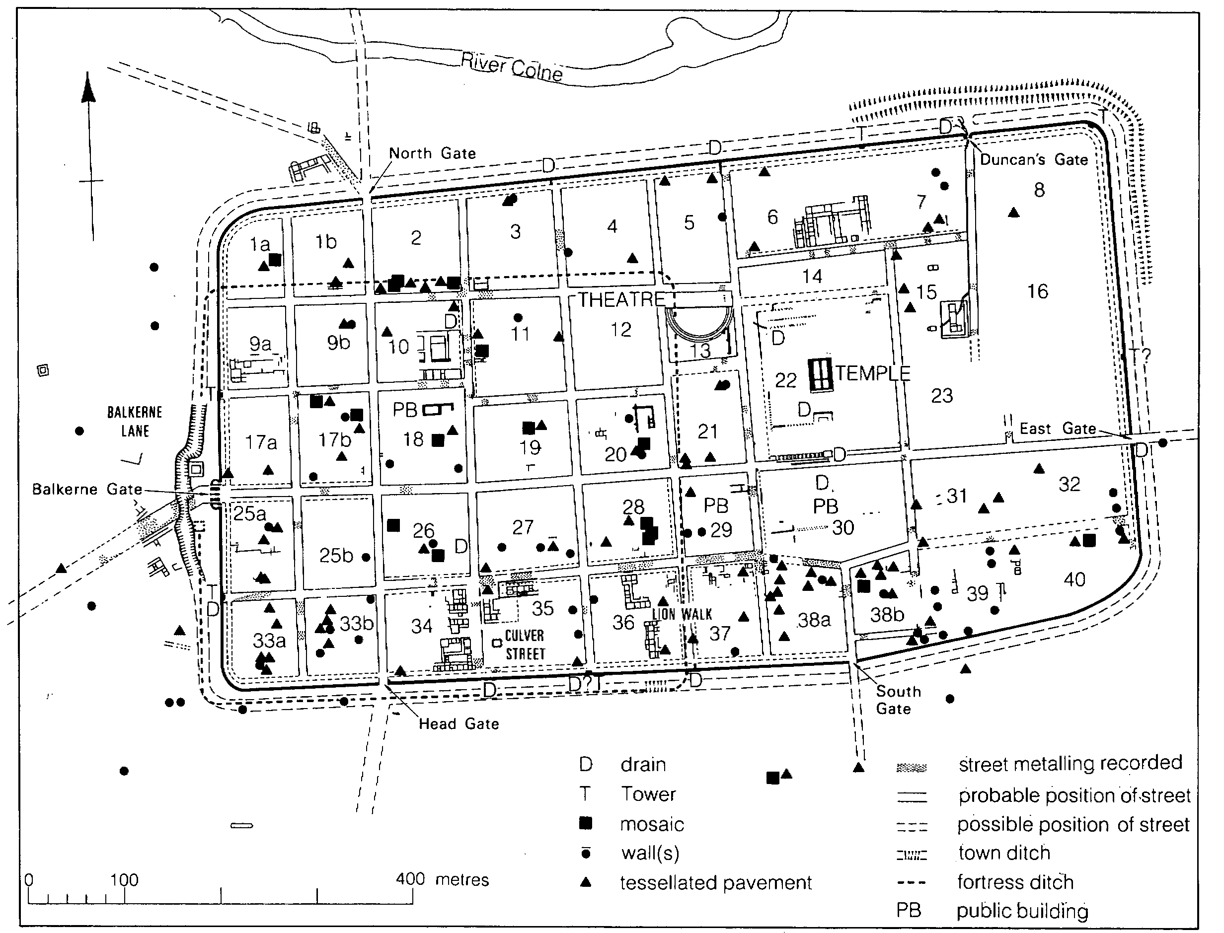
Roman Colchester, 2nd-4th century
Parts of many barracks, apparently including all the barracks of the First Cohort, (fn. 49) were re-used as houses in the new town. In the south-east corner of the fortress, however, only the four most northerly of the six barracks were kept; the southern pair was demolished and the site left vacant, later to be cultivated. (fn. 50) On the west side of the fortress the barracks were demolished well before 60-1 and a new street lined with buildings constructed to the north. (fn. 51) The centurions' quarters were suitable for re-use as houses because they fronted at one end on a principal street and were divided up internally into small rooms. The men's quarters were not so readily converted being in effect a series of small independent compartments fronting on minor streets.
There was probably insufficient space in the former fortress for all the large civic buildings which the colonists required. Accordingly the military defences were levelled so that much of the annexe could be used for such buildings. Tacitus recorded that in 60-1 the settlement was easy to destroy because it had no walls: 'That was a matter which Roman commanders, thinking of amenities rather than needs, had neglected'. (fn. 52) Those 'amenities' were presumably the group of public buildings laid out after the defences had been levelled. The colony was indeed unprotected in 60 A.D.; houses burnt in the revolt had been constructed over the levelled military defences, and those defences were not replaced until after the fire.
The buildings on the site of the military annexe included the temple of Claudius, (fn. 53) the theatre, (fn. 54) and at least two others, one in Insula 29 and another in Insula 30. (fn. 55) The building or buildings in Insula 29 seem to have had columns covered with fluted stucco. The excavated theatre may be later than the one referred to by Tacitus in his description of the omens seen in Colchester before the Boudican disaster, (fn. 56) but the remains of a pre-Boudican theatre may lie underneath it. (fn. 57) The temple of Claudius which dominated the site was a lavish building decorated with marbles and porphyry imported from various parts of the Mediterranean world. (fn. 58) On the west side of the colony a monumental gate of two arches, part of which survives as the Balkerne gate, was erected on the site of the porta decumanus. There is some uncertainty about the date of the arch but it was probably erected c. 50 A.D. to commemorate the foundation of the colony. (fn. 59)
Quite how the veterans acquired redundant military buildings is obscure. The army usually gave veteran soldiers either allotments of land or a lump sum to provide an annuity for their retirement. The land was normally divided on a grid system (centuriation) and the blocks apportioned accordingly. Such a scheme has not yet been positively recognized in Colchester, probably because its traces are difficult to detect. (fn. 60) Tacitus indicated that sometimes the process of land acquisition in Colchester was not as orderly as it ought to have been. The settlers drove the Trinovantes from their homes and land, and called them prisoners and slaves. The troops encouraged the settlers' outrages, since their own way of behaving was the same - and they looked forward to similar licence for themselves.' (fn. 61) The apparent free-for-all could be taken to imply the absence of centuriation, but more probably Tacitus was referring to large-scale unofficial excesses after the initial allocation of centuriated land, excesses which were to be one of the contributory factors to the revolt. The relationships of the fortress and the Gosbecks fort to the occupied areas of the native settlement hint that the Roman army made some attempts to live with the local population in as unabrasive a manner as the circumstances would allow. Rather than court conflict in the way described by Tacitus, the Romans may have initially acted diplomatically by not centuriating the most sensitive land. Tolerance of native rights and traditions allowed the survival of the Gosbecks site throughout the Roman period (it was clearly never confiscated for centuriation) and the development of the native sanctuary.
Just before the fire the town seems to have been well populated, although it was only c. 10 years old. The only empty space yet seen inside the former fortress area before the fire was on the site of the two barracks in the extreme south-east corner. (fn. 62) As it was a colony and thus technically a self-governing extension of Rome itself, only Roman citizens could hold land in the settlement. Retired veteran soldiers and their families were presumably the most important component of the population. Those without Roman citizenship perhaps occupied the area to the west of the town, where deep, narrow buildings huddled along the frontages of the road to London.
The story of the Boudican revolt and the burning of the town is well known. (fn. 63) The destruction was comprehensive; there are few places in the town where there is no evidence of the fire. Nevertheless, after the revolt it was possible to re-establish the earlier street system and to build new houses on pre-Boudican plots. (fn. 64)
The fire preserved evidence of life in the early colonia, including organic remains which, but for being carbonized, would not have survived. (fn. 65) In a pottery and glass shop in the street underlying High Street were fragments of what had been thousands of imported pottery and glass vessels, the pottery mainly red glazed terra sigillata and much of the glass thin-walled and delicately coloured. (fn. 66) Another shop, in the same street which was presumably a major commercial thoroughfare, stocked pottery, apparently only terra sigillata, besides foodstuffs including whole figs, coriander, cones of stone-pine, spelt, barley, and lentils. (fn. 67) Parts of a building in Insula 10 seem to have been used as a store rather than a shop. Separate rooms and a corridor contained large quantities of carbonized wheat, at least 30 unused and almost identical mortaria, more than 80 almost identical flagons, and 20 amphoras of various types. (fn. 68) Other organic finds from the Boudican destruction layer in the town include dates, a plum, and flax seeds. Most remarkable was a charred bed, consisting of two mattresses, in the corner of a room. (fn. 69)
It is difficult to say how quickly the town recovered after the fire. Rebuilding probably started immediately but the town never recovered its former density of buildings. Some areas, mainly those next to the town wall, were left empty and were used for cultivation when eventually a sufficiently fertile soil cover developed. Large cultivated areas are known in Insulae 17a, 34, 35, and 36. (fn. 70) Part of a ploughshare (fn. 71) was found in cultivated soil in Insula 35, while in Insula 34 there were impressions of the tips of spades. (fn. 72) A small tower granary in Insula 35 stood within an area of cultivated soil. (fn. 73) Much later, possibly in the 4th century, the site of the granary was occupied by a corn-drying kiln (fn. 74) and to the north was a large barn probably for agricultural use. (fn. 75) The clearest evidence for cultivation came from just outside the walls, near the Balkerne gate, where a large area of cultivated soil incorporated a series of raised parallel beds. (fn. 76)
The town walls were probably built soon after the revolt and presumably as a consequence of it. They have been dated to c. 65-80 A.D., (fn. 77) exceptionally early for Roman town walls, and were presumably an expensive statement that such devastation was not to happen again. The extent and quality of the later building outside most if not all the gates underline the token nature of the early wall as a defensive structure.
The period between the mid 2nd and the early 3rd century saw in Colchester, as in other towns, the appearance of substantial, well built town houses. (fn. 78) Areas which had been used for cultivation were built over in response to the need for new building land within the walls. (fn. 79) The houses themselves were often larger and of better quality than earlier ones, the courtyard house making its first appearance. Rubble foundations became the norm, especially for internal walls, and floors were frequently tessellated. Clearest testimony to the increase in affluence is the widespread introduction of mosaic pavements. Over 30 mosaics have been recorded in the town and, as far as can be judged, the overwhelming majority are of the period 150-250.
While the size and quality of the houses implies a period of prosperity, the population did not necessarily grow. Estimating its size with any degree of confidence is almost impossible, but if Insulae 34 and 36 were typical of the c. 41 insulae which did not contain public buildings, then the average such insula probably contained c. 6-8 houses. That suggests only c. 300 houses in the entire town and a population of perhaps only a few thousand. There were a number of localized fires in the town in the Antonine period, but no evidence has been found for a major fire which might have affected the town's development. (fn. 80)
From its earliest days, the colony appears to have been markedly agricultural in character and to have served as the main regional market for agricultural produce of all types. Opportunities presumably abounded in a fast-developing commercial and industrial town. The expanding civilian population (containing many men newly retired from the army with substantial cash sums), the port, the large native population in the area, and the prospect of lucrative military contracts to help supply a large campaigning army presumably combined to draw the skilled craftsman and the determined entrepreneur alike, regardless of whether or not he was a veteran soldier. Immigrants, especially from Gaul, may have figured prominently among them. A workshop that made clay lamps provides proof of artisan activities within the limits of the colony proper in the pre-Boudican period. (fn. 81) Other evidence, mainly in the form of waste products or specialist structures, points to metal working in iron and copper alloys, (fn. 82) glass working, (fn. 83) bone working, (fn. 84) and pottery and tile making. The pottery industry in particular was important to the local economy. It was active from the Claudio-Neronian period to at least the late 3rd or early 4th century, and was at its most successful from c. 140 to c. 200 when large quantities of pottery were being exported to other parts of the country, especially to forts on the northern frontier. (fn. 85) Coins may have been struck in Colchester in the late 3rd century but the evidence is ambiguous. There were at least two mints in Britain at that time, one denoted by the mint signature c or occasionally CL, which some numismatists consider stood for Colonia (i.e. Colchester). (fn. 86)
The distinction between Camulodunum and the Roman colony made in the 2nd-century inscription is reflected in the locations of the two types of temple erected in the settlement. Within the walls of the Roman town was the temple of Claudius, (fn. 87) the great classical temple worthy of Rome itself, whereas scattered across Camulodunum were at least seven temples of Romano-Celtic type, including those at the native sanctuaries at Gosbecks and Sheepen. (fn. 88)
It has been suggested that with the coming of Christianity the front of the temple of Claudius was radically remodelled in the 4th century to convert it to a church and that integral to that remodelling was the addition of an apse which was to become a dominant feature of the plan of the Norman castle. (fn. 89) The evidence is inconclusive and the fact that the White Tower in London, which is like Colchester in many respects although it is not built on Roman foundations, has a very similar apse, might suggest a Norman date for the Colchester apse. Structural changes were made to other religious buildings at a similar date, although their significance is not clear. The ambulatory of the Romano-Celtic temple outside the Balkerne gate (Temple 10/Building 52) was demolished and its foundations robbed out in the later 4th or the early 5th century. (fn. 90) The temple stood across the street from a building which may also have been a temple (Building 53) and which was completely demolished and its foundations removed, probably in the 5th century. (fn. 91) When the other temples were demolished is unknown, though Temple 2 appears to have been in use at least until the late 4th century. (fn. 92)
The church and its associated cemetery at Butt Road indicate that a substantial part of the population of the 4th-century town was Christian. The cemetery contained at least 600 inhumations, possibly a great many more. The church started c. 330 as a rectangular building, but an apse was later added to its east end. The building had an outer wall of rubble, a tiled roof, and a simple floor of sand. Later, wooden posts were inserted into its eastern half to form aisles. There may have been as many as three graves near the east end; the earliest may have predated the church and been the grave of an important local Christian. Large quantities of animal bone indicate that funerary meals were consumed in the building and that large chicken and young pig were especially favoured. A femur and the skull (but without mandible) of a small, middle-aged woman had been placed at the base of a deep pit inside the building near the apse, probably in the 5th century when it was dilapidated. Both bones appear to have belonged to the same person and may represent an early occurrence of the practice of depositing relics in a church. (fn. 93)
The function of the building in Insula 15 once identified as a mithraeum is now uncertain. (fn. 94) The presence of a spring in the building indicates that its purpose involved water, and the most obvious explanation is that it housed some kind of lifting or pumping device for the water supply. The iron shackles (fn. 95) from the building point to the use of slaves to drive the equipment.
The cemeteries of Roman Colchester, providing one of the largest pools of information about Romano-British urban cemeteries and burial practice, have yielded more than 1,400 graves and about 2,000 objects, excluding coffine nails and human bones. (fn. 96) There was a concentration of tombstones and sculptured stone on the frontages of the main approach road to the west side of the colony, the most esteemed of the cemetery areas. Among them were the tombstones of Facilis and Longinus, a 'walled cemetery', (fn. 97) and a monument incorporating the so-called Colchester Sphinx. (fn. 98)
Most cremation burials in Colchester seem to have consisted of a cinerary urn and possibly one other vessel. The richest burials tend to come from the area on the south-west side of the town. There is no clear evidence for the date of the change from cremation to inhumation. Either the transition occurred c. 260 or for a long period until then the rites were used concurrently. (fn. 99)
At the cemetery at Butt Road 742 inhumations were found. There were effectively two cemeteries, the first and smaller being of the 3rd and early 4th century with burials arranged roughly north-south. In the second cemetery most inhumations were east-west and of the 4th century; they were probably Christian and contemporary with the cemetery church. More than half the graves of the first cemetery contained at least one object. In the second cemetery grave goods were rarer: only 6 per cent of adults and 12 per cent of children were accompanied by objects, mostly the personal adornments of women and girls. (fn. 100)
Over 90 per cent of the excavated inhumations at Colchester were in wooden coffins. Coffins made of split tree trunks were found at Butt Road, but at least 21 other recorded coffins from the town were either entirely of lead or were of wood lined with lead. Stone coffins seem to have been very rare in Roman Colchester, only two being attested. The bodies in at least four lead coffins and seven wooden ones, all but one from Butt Road, had been covered or at least partly covered by some kind of plaster. The objects in the graves do not seem to have been specially made funerary pieces but to have been in everyday use, and it seems likely that some were important or favoured possessions of the dead person. Some vessels were poorly made and of inferior quality, even including wasters. Often they are coated internally with lime-scale showing prior use. A large proportion of the objects are small examples of their type. Presumably such objects usually indicate the graves of children, with whom small pots and lamps could have been associated in life. (fn. 101)
The Decline of the Colony
The threat of Saxon raids along the east coast appears to have become serious in the period 268-82 when major improvements were made to the coastal defences in south-east England. Two forts in the system, Bradwell-on-Sea and Walton Castle (Suff.), are near Colchester and probably belong to the period 276-85. (fn. 102) Colchester lies less than 10 miles from the coast and, although protected to an extent by those two forts, was still vulnerable to sea-borne raiders especially via the mouth of the river Colne. Three coin hoards from the Colchester area, all dating to c. 275, (fn. 103) attest the feelings of insecurity widespread at the time. Steps were taken to improve the defences of the town. Initially the town ditch was substantially widened and a counterscarp bank formed with the soil dug from it, but before the end of the century sterner measures had been taken. The Balkerne gate was closed when the town ditch was extended to cross in front of it, and traffic was diverted, probably through Head gate. Duncan's gate, in the north-east part of the town, may have been similarly closed by continuing the town ditch across the front of it. (fn. 104) The Balkerne gate was probably blocked because its incorporation of the earlier monumental arch made it unsatisfactory as a defensive structure. (fn. 105) Duncan's gate may have been sacrificed because it was small, only one carriageway wide, and little used as there was not much space between it and the river for buildings.
While the changes were being made to the town defences, the built-up area of the town was shrinking. The change was most marked in the extramural areas outside the Balkerne gate and North gate where practically all the buildings were demolished during the period 275-300, (fn. 106) presumably because of their exposed positions. The decline of the extramural built-up areas is indicated by changes in the distribution of burials. Most inhumations (datable broadly to the 3rd and 4th centuries) are closer to the walls than most of the cremations (datable to the 1st and 2nd centuries): areas where burial was permitted crept inwards as the built-up part of the town shrank. (fn. 107)
The near-extinction of the suburbs was not matched by an increase in the built-up area inside the defences, and in the 4th century the open areas within the walls became larger as houses were knocked down and not replaced. At the Culver Street site, the only 4th-century building seems to have been the barn referred to above, (fn. 108) and at the Lion Walk site half of the six houses had been knocked down by the middle of the 4th century. (fn. 109) Late pottery and coins show continued activity in the court of the temple of Claudius until at least c. 365. The same material has been used to argue that after that date the buildings forming the court were modified for use as some kind of domestic citadel. (fn. 110)
The population of the late Roman town was not necessarily diminishing; the pattern of occupation within the walls may have been changing. It is striking that the intramural sites with the highest proportion of late Roman material (the Cups Hotel and the Angel Yard) (fn. 111) are both in High Street. The demolition of extramural and intramural houses may have been matched by the growth of a medieval-style town where the houses were smaller and focused on one street.
There have been suggestions that Roman Colchester came to a dramatic and violent end. The bones of a young woman lying obliquely on a tessellated floor of a building in Insula 40 have been interpreted as evidence of that end, (fn. 112) but it is far more likely that the body was buried in a shallow grave whose digger stopped when he reached the floor. Duncan's gate has been thought to provide convincing evidence of an assault which met with some success, but that evidence, from an excavation of 1927-9, (fn. 113) cannot be reassessed. The gate appears to have been burnt on at least two occasions in the late Roman period. The second fire was the more serious. Brushwood was piled up against the outer face of the wooden doors and set alight causing the doors to collapse inwards. The heat was so intense that many stones turned red. The two fires are not closely datable but the first was probably no earlier than 367 and the second substantially later. The fact that there were two fires shows that the town survived the first assault (if indeed that was the cause of the first fire). The debris from the second fire, however, does not appear to have been cleared away, implying that the gate was never repaired. If the interpretation of the excavation is correct, then the gate may provide proof of a violent end to the Romano-British administration.
A small hoard of clipped silver coins (fn. 114) provides evidence of the breakdown of centralized Roman government c. 409. By then Britain had in effect ceased to be part of the Roman empire and the local British councils, the civitates, had taken steps to provide for their own defence. The hoard belongs to a rash of groups of clipped coins which appeared in Britain at the period. Apparently the clipping of coins had until then been controlled by the imposition of severe penalties on offenders but with the break from Rome the practice became commonplace. (fn. 115)
Three huts within Colchester's walls and a scatter of contemporary finds show that the town was one of the many places where the Saxons settled. (fn. 116) The fate of the Romano-British population of Colchester is unclear but life in the town was certainly radically different by the mid 5th century, the date of the earliest known Saxon hut. (fn. 117) Before the change, there is likely to have been a period when the population was in rapid decline. Traditional customs may have started to break down. Two decapitated burials from the grounds of East Hill House may belong to the period, since contrary to normal practice they were inside the walls. (fn. 118) It is uncertain whether elements of the Romano-British population survived the transition. Some houses were left standing and unoccupied so that topsoil and broken roof-the accumulated on their floors. (fn. 119) Public buildings such as the theatre and the temple of Claudius became ruins (if they had not already been so in the late Roman period) and even minor structures like the probable corn-drying oven at Culver Street seem to have been left to decay.