A History of the County of Northampton: Volume 5, the Hundred of Cleley. Originally published by Victoria County History, London, 2002.
This free content was digitised by double rekeying. All rights reserved.
'Old Stratford', in A History of the County of Northampton: Volume 5, the Hundred of Cleley, (London, 2002) pp. 198-207. British History Online https://www.british-history.ac.uk/vch/northants/vol5/pp198-207 [accessed 19 April 2024]
In this section
OLD STRATFORD
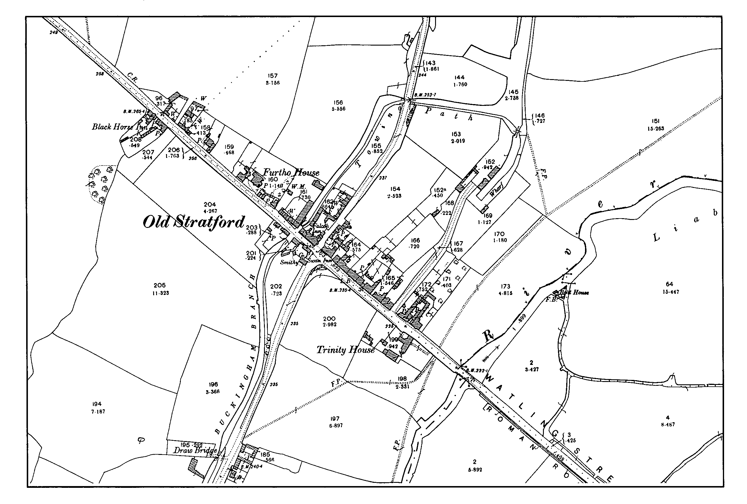
The village of Old Stratford grew up on either side of Watling Street close to the point at which it crossed the river Ouse into Buckinghamshire, where the larger settlement of Stony Stratford similarly developed alongside the Roman road. The second half of both names obviously refers to the river crossing, but the first half of 'Old Stratford' is a corruption, not found before the 15th century, of what was previously 'For Stratford' or West Stratford, referring to its position in relation to its larger neighbour; the notion that the village is in some sense older than Stony Stratford is mistaken. (fn. 1) An early 17th-century map names the village as 'Old Stow' (and an adjoining common field in Passenham as Little Stow Field); (fn. 2) this form has not been found elsewhere.
Since Watling Street here formed the boundary between Passenham on the south and Cosgrove on the north, Old Stratford lay partly in one parish and partly in the other. (fn. 3) In addition, the last house at the west end of the village on the northern side of Watling Street, the homestead belonging to Furtho Rectory Farm, lay just inside Furtho, (fn. 4) and until the area was added to Cosgrove in 1883 (fn. 5) there was a detached portion of Furtho on the same side of the road at the opposite end of the village. A detached area of Potterspury, also on the Cosgrove side of Watling Street, was transferred to the latter parish in 1916. (fn. 6) In 1875 the rector of Furtho detected (not for the first time, he claimed) a threat to saddle his parish, which he believed then contained only four houses, with part of Old Stratford, (fn. 7) and in 1914 the duke of Grafton's agent suggested that Old Stratford should be added to Furtho. (fn. 8) This was strongly opposed by the trustees of Edmund Arnold's charity, (fn. 9) the main owners there, and the only action taken involved the detached area of Potterspury. (fn. 10) Not until 1951 was a civil parish of Old Stratford created, made up of parts of the civil parishes of Deanshanger (formerly Passenham) to the south of Watling Street and Cosgrove and Furtho to the north. (fn. 11) The Arnold trustees again objected to the inclusion of their estate in Old Stratford, (fn. 12) which was instead added to Potterspury, while the remainder of Furtho (which was finally abolished as a civil parish) passed to Cosgrove, whose parish council supported the creation of Old Stratford, despite the loss of rateable value this entailed. (fn. 13) Ecclesiastical parish boundaries were unaffected by these changes. (fn. 14)
Seventeen households were assessed to the hearth tax in Old Stratford in 1674, none of them discharged through poverty. (fn. 15) It is impossible to decide whether this includes the entire community, or whether other households were assessed in Cosgrove (whose own assessment certainly included Furtho), Passenham or Potterspury. In the 1830s there were 39 houses in Old Stratford, divided between the four parishes with land in the village, (fn. 16) and thus the population must have been around 150- 200. (fn. 17) This figure had risen to about 260 by the First World War. (fn. 18) Old Stratford shared in the general growth of population experienced by most of the parishes in the district in the 1950s and 1960s, and by 1970 the population had passed 1,000. Further expansion was then severely restricted, following the designation of the adjoining area of north Buckinghamshire (including Stony Stratford) as the site of Milton Keynes, since Northamptonshire was determined not to allow villages close to the county boundary to be absorbed into the built-up area of the new town. (fn. 19)
To some extent, Old Stratford has probably never been more than a suburb of its larger neighbour, although it has a focus of its own in the crossroads in the middle of the village. Until the building of the M1 motorway, this was the point at which the main route from London to Northampton branched off from Watling Street, and from which a route ran up the Ouse valley to Buckingham. (fn. 20) The Northamptonshire section of Watling Street, from Old Stratford to Dunchurch, was turnpiked as early as 1707; (fn. 21) a trust for the road from Old Stratford to Northampton was established in 1768; (fn. 22) and the road from Buckingham to Old Stratford (forming part of a route which continued to Newport Pagnell) was turnpiked in 1815. (fn. 23) The Maynard estate sold land to the trustees of the Old Stratford to Dunchurch turnpike in 1780 to enable the road to be widened. (fn. 24) Even after the southern section of the M1, opened in 1959, largely superseded Watling Street as the main road from London to the Midlands, the crossroads at Old Stratford remained a busy junction until the village was bypassed in both directions in the 1980s.
Old Stratford Village
The river crossing from which both Old Stratford and Stony Stratford derive their names must have been replaced by a bridge, first mentioned in the 13th century, (fn. 25) at an early date, although in the 1830s Baker claimed that the site of a ford could be identified immediately upstream from the bridge. (fn. 26) In the early 17th century the bridge crossed the Ouse itself by a single span, flanked on the Buckinghamshire bank by a causeway pierced by three groups of three arches, apparently built to carry water off the meadowland alongside the river. (fn. 27) The bridge is said to have been partly destroyed in the Civil War and then to have become dilapidated. (fn. 28) In 1801 an Act for paving, lighting and improving Stony Stratford also provided for the repair of the bridge, whose maintenance had, ,since the early 16th century, been the responsibility of a local charity. (fn. 29) This measure was evidently insufficient, and in 1834 the two counties which shared responsibility for the bridge obtained another Act, under which a new bridge was built the following year. The Act provided for the cost of the bridge to be divided between Northamptonshire and Buckinghamshire; for tolls to be collected for 21 years; and for the charity which had previously maintained the old bridge to be discharged from this responsibility. (fn. 30) Tolls were apparently taken at the bridge in the Middle Ages. (fn. 31)
When the Grand Junction Canal was promoted in 1793, the original scheme provided for a side-cut, about a mile long, from just north of the point at which the main line crossed the Ouse to Old Stratford, thus linking the canal with Watling Street. (fn. 32) The following year the company proposed to extend the branch to Buckingham, about eight miles away, partly by making the Ouse navigable and partly by building new lengths of canal. (fn. 33) The scheme was approved by Parliament, (fn. 34) but as constructed the branch consisted entirely of an artificial cut, with no use made of the river. The first part of the Buckingham Arm of the Grand Junction ran to a wharf, with a warehouse, on the edge of Old Stratford a short distance to the north of Watling Street, to which it was linked by a lane. The extension to Buckingham ran west and then south from the wharf to pass beneath Watling Street immediately west of the crossroads in the village, continuing out of the village alongside Deanshanger Road. (fn. 35) The wharf at Old Stratford handled a considerable traffic, with hay and straw being sent to London and coal brought in, throughout the 19th century. It was also used to launch many of the smaller boats made at Edward Hayes's boatyard in Stony Stratford, which were hauled along Watling Street by traction engine. (fn. 36) The last commercial traffic at the wharf ceased in 1932, although the canal itself closed only in 1961. (fn. 37) The extension to Buckingham was disused before the Second World War. (fn. 38)
Old Stratford was never served by a main line railway, but in 1885 the Stony Stratford Light Railway Co. secured powers to build a line from Deanshanger to Wolverton. The section from Wolverton to Stony Stratford opened in 1887 and was extended through Old Stratford to Deanshanger the following year. The tramway, on which large double-decker carriages were hauled by a small steam locomotive, crossed the bridge, ran alongside London Road to the crossroads, where a depot was built in the south-eastern corner of the junction, (fn. 39) and then followed Deanshanger Road to terminate at E. & H. Roberts's foundry at Deanshanger. The original company failed in December 1889 and, although the Buckinghamshire section was reopened by another concern two years later and remained in use until 1926, the Deanshanger branch was lifted. (fn. 40)
Landscape and Settlement.
Until the modern growth of the built-up area, the village of Old Stratford extended for about a third of a mile along Watling Street from the bridge up to the brow of a hill, where the road is about 40 ft. above the level of the river. (fn. 41) Close to this point, on or near the site later occupied by Furtho Rectory Farm on the northern side of Watling Street, stood a hermitage and chapel, dedicated to St. John the Baptist, established by the mid 14th century, if not earlier. (fn. 42)
The site of the hermitage lies beyond the limits of mapping on the early 17th-century survey of Whittlewood, which does, however, mark a house on the opposite side of Watling Street at the same point. (fn. 43) It also shows a house at each corner of the crossroads in the centre of the village, another four on the Cosgrove side of the road between the crossroads and the river, and one on the Passenham side of Watling Street, making a total of ten. Some of the buildings shown presumably represent more than one dwelling, but the overall impression of a small village whose buildings were strung out along Watling Street, with more houses on the northern side of the road than on the south, and no secondary development along either Cosgrove Road or Deanshanger Road, is confirmed by the late 19th-century Ordnance Survey map, which shows much the same picture. (fn. 44) Equally, in the 1830s only nine of the 39 houses in the village were in Passenham parish, whereas there were 27 in Cosgrove, two in Furtho and one in Potterspury, all on the northern side of the main road. (fn. 45) The early 17th-century map marks all the houses standing in crofts whose boundaries were still evident in the late 19th century, and it is possible that those on the Passenham side of Watling Street, both west and east of the crossroads, once contained more than the four houses shown on the early map.
Old Stratford had no field system of its own. Beyond the crofts behind the houses lay the common fields of Passenham to the south and Cosgrove and Furtho to the north. (fn. 46) None of the houses in the village appears to have been a farmstead before the 19th century, when Furtho Rectory Farm was built at the western edge of the village at the southern end of the recently inclosed glebeland of that parish. In the late 19th century the tenant of Furtho Manor also lived at Old Stratford, since the house on the farm was by this date unfit for habitation, (fn. 47) but the place was never a farming village in the sense that its neighbours were. Rather it appears to have been a small community of traders and craftsmen, relying for its prosperity on its position on Watling Street and also, during the 19th century, a major canal route. (fn. 48)
The building of the tramway through the village in 1888 required the creation of a radiused, rather than right-angled, junction at the south-eastern corner of the crossroads, (fn. 49) and as motor traffic increased similar improvements were carried out at the other corners before and after the First World War. At the south-western corner a coach-building works and smithy were cleared away and replaced by a shop, into which the village sub-post office (opened in a shop on London Road near the canal bridge two years before) moved in 1914. (fn. 50) The former tram depot became a motor and engineering works. (fn. 51)
In 1919 a public hall was built on Deanshanger Road, near the crossroads, as a memorial to those who had died in the First World War; previously the waiting room at the old tram depot had served as the only meeting place in the village. Over the next few years new houses began to be built in various parts of the village. The first were a group of twelve (Willow Terrace) in Cosgrove Road and three others in Wharf Lane. (fn. 52) By the late 1930s building extended along Cosgrove Road as far as the bridge over the disused Buckingham branch canal; on both sides of London Road between the crossroads and the sites previously occupied by the Black Horse inn and Furtho Rectory Farmhouse (both of which had been demolished); and down the eastern side of Deanshanger Road for a distance of nearly half a mile. On the southern side of London Road, opposite Furtho House, a new cul-de-sac, Mount Hill Avenue, had been laid out at right-angles to the main road. Apart from half a dozen detached houses on the western side of Cosgrove Road, almost all these developments were of privately built semi-detached houses. The whole of London Road, apart from the stretch near Trinity House between the crossroads and the river, was built up by 1938. (fn. 53)
When private building re-started in the 1950s, land to the south of London Road on both sides of Deanshanger Road was released for development. To the west of the crossroads Mount Hill Avenue was extended to become a spine road serving a number of culs-de-sacs, while to the east a road was built running off Deanshanger Road, using a gap left in the prewar ribbon development, almost to the river bank. In 1946 the village acquired a children's playground, the gift of W.W. Dickens, who had bought Furtho glebe in 1921 and later lived at Furtho House; other post-war improvements secured by 1960 included street lighting and the installation of traffic lights at the crossroads. By this date gas, water and electricity were all available in the village, whereas at the turn of the century only six houses (out of about 70) had piped water, which came from an artesian well in Wharf Lane; the rest relied on wells and pumps. (fn. 54) A primary school was opened in 1966. (fn. 55) Although there was no industry as such in the village, land on the west side of Cosgrove Road to the north of the houses on London Road was developed as a depot by the North Buckinghamshire Water Board.
In the 1980s a more fundamental change in the topography of the village resulted from the building of a new trunk road (replacing Watling Street) through Milton Keynes, which bypassed Stony Stratford to the north, crossed the Ouse about half a mile downstream from the old bridge, and rejoined the line of the Roman road at a roundabout on the western edge of the built-up area of Old Stratford. To the south of Watling Street, the road from Buckingham was taken on a new alignment from the end of the built-up area on Deanshanger Road, round the western side of the village to the new roundabout, from which a new road was built to replace Cosgrove Road as the main road to Northampton, rejoining the old road north of Dogsmouth Bridge. Deanshanger Road and London Road remained in use after these changes, completed in 1985, but Cosgrove Road was severed as a motor road by the new bypass, leaving only pedestrian access to the north. The new road also severed the line of the branch of the Grand Union Canal immediately north of the old wharf at Old Stratford. No provision was made for the possible reinstatement of the canal to the wharf.
In 1999 the former tram-shed at the crossroads was demolished and replaced by low-cost housing.
MANORS AND OTHER ESTATES.
Apart from one conveyance of the 'manor of Old Stratford' in 1574, which appears to be an anomalous description of a freehold estate purchased that year by Robert Kirkby from Thomas Duncumbe and his wife Isabel, (fn. 56) there is no evidence for a manor of that name. Most, if not all, the premises on both sides of Watling Street seem to have been free tenements of the manors of Cosgrove, Furtho or Passenham, and in the Middle Ages Old Stratford appears frequently in lists of places in which those manors, (fn. 57) and other estates, (fn. 58) held lands. In 1566 the manor of Passenham included land and cottages in Old Stratford (10 a. in all) on both sides of Watling Street (fn. 59) and in the early 17th century a number of houses on the northern side of Watling Street paid quit rent to the manor of Furtho. (fn. 60) The Passenham Manor estate included a small farm (44 a.), several cottages and some accommodation land in Old Stratford when it was broken up by sale in 1911. (fn. 61) On the other hand, evidence of deeds of all periods suggests that ownership in Old Stratford was always much divided between freeholders and was never dominated by any of the estates in adjoining parishes. (fn. 62)
The Hospitallers had premises in Old Stratford belonging to their preceptory at Dingley, as well as land in the adjoining parishes of Cosgrove and Passenham. (fn. 63) So too did 'St. John's Friary', Northampton, who had two tenants in the village in the early 16th century. (fn. 64)
The Hermitage Estate.
In 1352 Robert de Seymour and Robert Paveley received a grant of pontage for three years in aid of the causeway from Stratford bridge towards the Shrobb (i.e. the portion of Whittlewod which adjoins Watling Street immediately to the north of Old Stratford) (fn. 65) and the chapel of the hospital of St. John, which was for the most part ruinous. (fn. 66) The reference to the Shrobb implies that the causeway lay on the Northamptonshire side of the bridge and that the 'hospital' was in fact the hermitage and free chapel at the western edge of Old Stratford, rather than the leper hospital in Stony Stratford, which shared the same dedication. (fn. 67) Similarly, a pavage grant of 1391 to repair the highway 'between the two Stratfords' may refer to the portion of Watling Street running from Stony Stratford to Old Stratford, rather than Fenny Stratford, since one of the grantees was John Haywood, 'ermyte'. (fn. 68) In 1400 John Blawemuster, hermit, received a grant of pontage for three years, to be spent on the repair of Stony Stratford bridge under the supervision of John Rotherham, clerk, and John Cope, lord of the manor of Deanshanger. (fn. 69)
The connection of the Broughton family of Toddington (Beds.) with the hermitage may originate with a purchase in 1430 by John Broughton from Richard Nuncourt and Elizabeth his wife of a third part of eight messuages, three tofts, 120 a. land, 10 a. meadow and 30s. rent in Stony Stratford, Puxley, Furtho and Cosgrove; (fn. 70) John's grandfather, Thomas Pever, from whom he inherited Toddingon at his death in 1429, appears not to have held any lands in Northamptonshire. (fn. 71) John Broughton died in 1489 seised of five messuages said to be in Stony Stratford, Furtho, Cosgrove and elsewhere in Northamptonshire, held of Thomas Mulso by service unknown, worth 40s. a year, when his heir was his grandson Robert, the son of his son John. (fn. 72) Robert was succeeded by a son named John, who died in 1518 leaving a fiveyear-old son, also John, as his heir, (fn. 73) who died under age in 1530, when his estates were divided between his two sisters and coheirs, Catherine and Anne. (fn. 74) Catherine married William, younger son of Thomas Howard, 2nd duke of Norfolk, and died in 1535, leaving as her only issue a daughter Agnes, who married William Paulet, later 3rd marquess of Winchester. (fn. 75) Catherine's share of her father's estate passed to the Crown when her husband was convicted of misprison of treason in 1542. Although he was pardoned two years later, (fn. 76) the estate remained in Crown hands until 1548, when Paulet and his wife were granted licence to enter the moiety of her father's lands which ought to have descended to her, including premises in Old Stratford. (fn. 77)
Although the hermitage was certainly part of the former Broughton lands forfeited by Howard to the Crown, (fn. 78) it appears not to have been included in the grant to Paulet of 1548, for in 1562 Cecily Pickerell was granted the site, grounds and precincts of the chapel or hermitage, containing five bays of building, an orchard, an acre of meadow, a rood of pasture and 4½ a. arable, to hold in free socage. Cecily was the widow of John Pickerell, treasurer to Edward duke of Somerset, and the grant was made in part repayment of debts due to her husband at the time of Somerset's execution in 1552, when it was enacted that his debts should be satisfied out of the issues of his lands which came to the Crown when he was attainted. (fn. 79) This possibly suggests that the hermitage estate had briefly been held by Somerset.
Mrs. Pickerell appears to have sold the house and land to George Ferne, who in turn sold the premises to Thomas Furtho, whose son Edward died in 1620 seised of the hermitage or free chapel of Old Stratford, its site and precincts, including land in Old Stratford, Cosgrove, Passenham and Furtho, which his father Thomas had purchased from George Ferne. The premises were valued at 2s. a year. (fn. 80) His son, also Edward Furtho, died the following year holding the same estate, which was then divided between his two sisters. (fn. 81)
In 1610 the Crown sold to Thomas Ely and George Merriell of London several pieces of land said to lie within Whittlewood Forest, and also what was described as the Hermitage House with garden, orchard and curtilage, and six closes of land, containing 186 a. in all, of which five, valued at 14s. 2d. a year, lay together and were known as the Hermitage Close or Hermitage Grounds, and the sixth, worth 10s., was called Carlton Sart. (fn. 82) The Crown had recently recovered the premises as assarts and purprestures in Whittlewood from Otho Nicholson. (fn. 83) Ely and Merriell later sold this estate to Edward Furtho, who was the owner at the time of his death in 1620. (fn. 84)
A late 16th-century description of the boundary of Furtho parish, evidently copied from an earlier account, locates the hermitage immediately to the north of the main road on the western edge of Old Stratford, and describes the adjoining land on the Furtho side of the boundary with Cosgrove as belonging to the hermitage. (fn. 85) A perambulation of the bounds of the manor of Passenham of much the same date also places the hermitage close to Watling Street near the brow of the hill, (fn. 86) and in 1566 the manor included a close in Old Stratford in the tenure of Thomas Furtho, 'late appurtenant to the Hermitage'. (fn. 87) A terrier of 1504 names a piece of land in the same area as the 'Armites Half Acre' or 'Armitis Half', which lay within Quarry Field, one of the common fields of Cosgrove and Furtho, (fn. 88) in which Hermitage Meadow was another landmark in the early 17th century. (fn. 89) There was also a Chapel Furlong in the same area, (fn. 90) while the woodland on the opposite side of Watling Street, near Shrobb Lodge, was called 'Armitage Coppice'. (fn. 91) As late as 1849 there was a field at Old Stratford known as Chapel Close, which was said to be the site of the hermitage and chapel. (fn. 92) This cannot apparently be located but the 16th-century references place the buildings at or very close to the site later occupied by Furtho Rectory Farm, (fn. 93) implying that at some date after 1621 the hermitage lands became part of Furtho glebe. The farm buildings were demolished soon after Furtho glebe was sold in 1921. (fn. 94)
TOLLS OF OLD STRATFORD.
In 1542 all the Crown estate in Cosgrove and Deanshanger was annexed to the honor of Grafton on its establishment. (fn. 95) The honor appears not to have acquired any land in Old Stratford, but did own one quit rent there (fn. 96) and also what were later described as the tolls of the town of Old Stratford. In 1586 it was noted that no rent had hitherto been answered to the queen for the tolls, but that George Ferne (who was evidently in possession) was willing to pay 5s . a year in return for a 21-year lease with no fine, to which the Crown agreed. (fn. 97) Either he or a namesake was granted a new lease for 40 years in 1607, at the same rent but on payment of a £5 fine. (fn. 98)
In 1646 John Hillier the elder of Potterspury conveyed to his son of the same name, in return for board and lodging, his house in Potterspury and his other possessions, which included the unexpired years in his lease of the toll of Old Stratford. (fn. 99) Four years later it was noted that the improved rent of the tolls was worth £5 a year, that they had recently been held on lease by John Hillier and Thomas Fish, and that they had been out of lease for three years, during which time Hillier and Fish had retained possession. (fn. 100) Robert Hillier took a new lease for a fine of £16 in 1666. (fn. 101)
The tolls were included in the grant of the honor to the earl of Arlington in 1673 (fn. 102) and continued to be leased in reversion by Queen Catherine's trustees until her death in 1705. In 1675, when they were said to be in the tenure of John Hillier, they were leased for nine years from 1687 to Samuel Rolt, the tenant of the manorial demesnes at Alderton, (fn. 103) and in 1691 they were granted to William Forster for 15¾ year from 1696, still at 5s. a year, to keep up a term of 21 years. In 1702 William Plowman of Blisworth, who a year before had been granted a new lease for 10¾ years from 1711 and had taken an assignment of Forster's lease, in turn assigned the lease to John Hillier of Old Stratford in return for a fine of £16. (fn. 104) In 1757 Sarah French, the daughter of Thomas French of Old Stratford, successfully applied for a lease of the tolls for 21 years at £25 a year, (fn. 105) and this sum appears in the estate rentals (under Potterspury) for most of the 18th century. (fn. 106) In the 1830s Sarah Webb was being paid about £5 a year to keep the toll at Old Stratford, until it was discontinued at Lady Day 1837. (fn. 107)
Since Old Stratford never had a market and the bridge was maintained by a charity in the post-medieval period, it is not clear for what the tolls were paid, by whom, or from what date. Rather oddly, Bryant's map of Northamptonshire (1827) prints the legend 'Honor of Grafton' across the built-up area of Old Stratford, which may be a final echo of this institution.
ECONOMIC HISTORY.
Apart from a couple of farms whose land lay in either Cosgrove, Passenham or Furtho to one side of Watling Street or the other, (fn. 108) the economy of Old Stratford must have relied from an early date mainly on its position at an important junction of two major routes.
Inns.
Four inns can be identified in 17thcentury sources and there were three throughout the 19th century. For a long period Old Stratford's leading inn was the Saracen's Head, which stood on the Passenham side of Watling Street near the river, where a building existed in the early 17th century. (fn. 109) It was here that depositions were taken in 1694 during the Chancery action over the charity established by Edmund Arnold's will, including one from the innkeeper, John Smith, (fn. 110) and here also that Arnold's trustees held their meetings in the 1760s. (fn. 111) In 1753 the inn was sold by Lord Maynard, the main owner in Passenham, (fn. 112) to the tenant, William Clarke, together with about 5 a. of pasture fronting Watling Street between the river and Deanshanger Road. Clarke died the following year and the inn remained in his family's ownership (but not occupation) until 1849. It closed as an inn in the 1820s and, after being occupied as a private house for a few years, became a boys' school in the early 1830s, as it was until the 1880s. (fn. 113)
The Falcon Inn stood at the north-west corner of the crossroads, where again a building existed in the early 17th century. (fn. 114) The owner c. 1630 was Christopher Reeve, who had been succeeded by a man named Gibson by 1635. (fn. 115) George Emmerson was the owner by 1653; either he or a namesake was still there in 1700. (fn. 116) Between 1702 and 1707 a quit rent due to the manor of Furtho was paid by Goody Hillier, who had been succeeded by 1711 by Margaret Hillier, who died in 1715. (fn. 117) John Hobbs was the owner by 1725; (fn. 118) after his death in 1736 the inn passed to his widow Judith, who died in 1751, when it was inherited by Edward Forfett, a London limner, whose brother John had married the Hobbses' daughter Phyllis. During this period a fire, in May 1742, destroyed three houses standing on tofts adjoining the inn. (fn. 119) John Furnice paid rates on the Falcon in 1739, presumably as tenant. (fn. 120) Forfett died in 1761, leaving the Falcon to his daughter Frances, the wife of Isaac Riviere, a London goldsmith, who sold the property (on which two new houses had been built to replace those burnt down) the following year to Christopher French and John Hall, also of London, for £60. (fn. 121) In 1773 French and Hall sold the premises to Matthew Willison of Old Stratford for £150. His family retained the Falcon until about 1820, (fn. 122) after which it belonged to Josiah Michael Smith. (fn. 123) The inn was later acquired by the Kendalls of Dovehouse Farm, Deanshanger, and was sold with the rest of their estate in 1877. (fn. 124) It closed shortly before the First World War (fn. 125) and by 1925 the buildings had been demolished to improve the road junction. (fn. 126)
An inn whose site cannot be located (although it stood on the Cosgrove side of Watling Street) was the White Lion, bought by Thomas Penn in 1636 (fn. 127) and sold by him to John Wooddell, a London innholder, in 1647. (fn. 128) Two years later Wooddell conveyed the property to John Hobbs of Old Stratford, who married Thomas Penn's daughter Mary (fn. 129) and died in 1654. (fn. 130) The White Lion later passed to his nephew William Hobbs, who in 1688 left the property to his wife Mary and then to four sons. (fn. 131) A house which definitely stood on the Cosgrove side of the main road is described as the Welch Harp (suggesting that it had once been an inn) between 1689 and 1717, when it belonged to the Penn and Webb families. (fn. 132)
At the western end of the village, on the Passenham side of Watling Street, a building stood in the early 17th century on the site later occupied by the Black Horse inn, (fn. 133) which in 1871 was said to have been licensed for over fifty years. (fn. 134) The pub lost its licensed in 1920 and two years later the owners, Phipps of Northampton, sold the building, which was subsequently demolished, (fn. 135) leaving the Swan inn, near the north-eastern corner of the crossroads, as Old Stratford's only pub. The Swan is listed in directories from 1847, but appears to have no earlier history; plans for alterations to the house were approved in 1927. (fn. 136)
In the 1660s a carrier named Edward Ball was travelling weekly from Old Stratford to the Lion in St. John Street, London. (fn. 137) Throughout the 19th century there was always at least one coal merchant's business at the canal wharf. (fn. 138)
Other Trades and Crafts.
There was a potash kiln in Old Stratford in 1713 operated by Stephen Holwell; it burnt down in about 1745 and a house was built on the site. (fn. 139) Another kiln appears to have been newly built on the Cosgrove side of Watling Street in 1758, when it was occupied by James Hall. In 1759-61 it was in the hands of William Hobbs and from 1762 until at least 1772 the occupier was John Pinfold. (fn. 140)
There was a mill on the Cosgrove side of Watling Street near the northern end of the village in 1827, which appears to have been powered by steam as well as wind. (fn. 141)
As well as the usual village tradesmen, including a blacksmith from at least the mid 18th century, (fn. 142) there was a matting manufacturer, John Rush Knight, in the village in the mid 19th century. (fn. 143) Despite the decline in longdistance road travel, there was also a coachbuilding business in Old Stratford from the 1870s until about 1906, owned successively by John Page, (fn. 144) William Judge (fn. 145) and Thomas Page. (fn. 146) In 1910 Page was listed merely as a wheelwright, (fn. 147) although when his premises were sold as part of the Passenham Manor estate the following year they still included a coachbuilder's shop. (fn. 148) The Midland Automobile Engineering Co., established about 1903, described themselves as motor car builders up to the First World War; after the war the company simply ran a garage business from the old tram shed. (fn. 149) Another garage business, C.H. Cave Ltd., was established in the early 1920s in the buildings formerly occupied by Trinity School, (fn. 150) which continued to be used for that purpose at the time of writing.
A number of Old Stratford residents presumably always found employment in Stony Stratford, and this proportion no doubt rose with the expansion of the railway works at Wolverton in the later 19th century, as it did in the later 20th century with the development of Milton Keynes new town.
LOCAL GOVERNMENT
The Manor Courts.
Until the creation of the civil parish of Old Stratford in 1951, the village had no separate administrative identity. Apart from the detached portion of Potterspury, the houses on the Cosgrove side of Watling Street belonged to a township called Cosgrove and Stratford in the 15th century, for which a single constable was appointed. (fn. 151) On at least one occasion in the mid 17th century a court was held at Old Stratford for surrounding manors belonging to the honor of Berkhamsted, at which a constable appeared for Old Stratford, Furtho and Cosgrove. (fn. 152) In 1787 and 1821 Cosgrove manor court appointed separate constables and thirdboroughs for Cosgrove and Furtho, but not Old Stratford, although in 1838 and 1848 all three townships were given their own constable. (fn. 153) The houses on the opposite side of the main road were in Passenham, where the manor court regularly appointed a separate constable for Old Stratford. (fn. 154)
Vestry and Parish Council.
The Cosgrove and Passenham portions of Old Stratford were assessed to poor and other rates with the rest of those parishes in the 18th and early 19th centuries; although there was generally a separate heading in the ratebooks for Old Stratford, the village never relieved its own poor or maintained its own highways. (fn. 155)
After 1834 both Cosgrove and Passenham became part of Potterspury poor law union and thus Potterspury rural district in 1894. Both were transferred to an enlarged Towcester rural district in 1935 and in 1948 Passenham was renamed Deanshanger (without any change in boundary). Old Stratford became part of South Northamptonshire District in 1974. (fn. 156)
After the nomination of parish constables passed from vestries to parish councils in 1894, the Cosgrove council, at least in its early years, chose one for Cosgrove and another for Old Stratford. (fn. 157) In 1898-9 residents of the Cosgrove portion of Old Stratford tried unsuccessfully to secure the adoption of the Lighting Act for Old Stratford; the Passenham council refused to attend a joint meeting because their parish had not adopted the Act. (fn. 158)
In 1911 residents asked the rural district council to install piped water at Old Stratford but nothing was done before the outbreak of war put a stop to the scheme. (fn. 159) The project was later revived and and the waterworks opened in March 1927. (fn. 160) Originally powered by a windmill with an auxiliary engine, they were converted to electric operation in 1934 and enlarged the following year. (fn. 161)
Old Stratford was among the villages where the R.D.C. proposed to build houses after the First World War and land for a pair of cottages was acquired in 1920, although the scheme was abandoned the following year. (fn. 162) When pressed by the Ministry of Health in 1926 either to use or dispose of the site, the council built two houses which were ready for occupation in September 1927. (fn. 163)
Early in 1950 local residents began to campaign for the creation of a civil parish of Old Stratford. After a public inquiry the county council made an order to establish a parish, with a nine-member parish council and one rural district councillor, consisting of 806 a., taken from Cosgrove, Deanshanger and Furtho. After local objections to the proposed northern boundary of the new parish, an additional area, including Shrobb Lodge (in Deanshanger) and Knotwood Farm (in Furtho), was added to Old Stratford, bringing its size up to 1,334 a., closer to those of adjoining parishes. As modified, the order was confirmed and took effect on 1 April 1951. (fn. 164) Seven street lamps on the Cosgrove side of Watling Street, installed in 1949 by Cosgrove parish council, were transferred to the new Old Stratford council. (fn. 165)
As in other Northamptonshire communities close to Milton Keynes, the work of Old Stratford parish council in the 1970s and later was increasingly dominated by planning issues, especially the need to prevent the excessive expansion of the village and to maintain a balance between cheaper and more expensive housing. (fn. 166)
CHURCH
The Free Chapel of St. John.
A chapel associated with the hermitage which stood on Watling Street at the northern end of Old Stratford appears to be first mentioned in a pontage grant of 1352. (fn. 167) In 1376 John Goodrich purchased a third of the manor of Puxley and a third of the advowson of the chapel of Little Stratford from Richard Hartshill and Isabel his wife, (fn. 168) and in 1494 the hermitage received a bequest of 12d. from Thomas Pesenest of Stony Stratford. (fn. 169)
During the period in which the hermitage estate was held by the Crown in the early 16th century, (fn. 170) the rector of Furtho, Thomas Ball, was accused of removing from the chapel vestments, furnishings, and images of the Virgin, St. John and another saint. His answer was that the chapel lay within his parish, that the patron of Furtho was also patron of the chapel, and that the rector of Furtho, before the dissolution of the hermitage, was accustomed to say mass at the chapel at certain times of the year, when a chalice, vestments and ornaments were taken from the parish church (to which they belonged) to the chapel but always returned afterwards. The patron of Furtho had removed a bell and the three saints' images from the chapel to the parish church, but only to save them from theft. He claimed to know nothing about the disappearance of an alabaster altar from the chapel. (fn. 171)
The Quest for a Chapel of Ease.
In the mid 19th century the schoolroom at Trinity School was licensed for worship, with a service every Sunday evening. (fn. 172) In 1871 residents petitioned the Revd. H. J. Barton of Wicken (as rural dean), thanking the bishop for allowing services to be held there but asking that, in view of the uncertainty of this arrangement, a church might be erected in the village, for which they understood a site had been promised. Although Barton noted that Passenham vestry opposed the project, he and the rector of Passenham later that year obtained from James Thomas, who had succeeded his father John as proprietor and headmaster of Trinity School, a parcel of land on the school estate at the south-east corner of the crossroads for a church for Old Stratford, with reversion to Thomas if the building was not erected within three years. (fn. 173) The project did not go ahead and the land was later occupied by the tramway waiting room. (fn. 174)
When Jesus College, Oxford, sold the main portion of Furtho glebe to the sitting tenant in 1921, they retained one field in Old Stratford itself with a frontage to Watling Street as a possible church site, but by 1933 it was clear that the land would not be needed for this purpose and it was sold for house-building. (fn. 175) After the creation of the civil parish in 1951, some residents hoped that a church would follow, but instead efforts were made to restore the medieval parish church at Passenham, which lay within Old Stratford parish and had fallen into decay after the building of a new church at Deanshanger in the 19th century. (fn. 176)
NONCONFORMITY.
In 1838 a house in Old Stratford in the occupation of John Cox was certified as a dissenting meeting-house. (fn. 177) It appears to have no later history.
EDUCATION
Elementary and Primary Education.
Writing in 1875, the rector of Furtho described Old Stratford as a 'sadly neglected place', without a church or school, (fn. 178) and this remained true of the rest of the 19th century. Although National schools were established in both Cosgrove and Deanshanger, which children living in Old Stratford were eligible to attend, (fn. 179) neither parish sought to build a school closer to hand. Some children probably attended schools in Stony Stratford, which were nearer than those in either of the other villages, an arrangement formalised under the 1870 Elementary Education Act. After 1902, when it became clear that the existing school at Cosgrove needed replacing, the county education committee considered building an infants' school at Old Stratford but did not proceed with the idea, since the Board of Education took the view that children from the village could (and should) continue to go to Stony Stratford. (fn. 180) In 1930, faced with falling numbers at Cosgrove, the managers and district subcommittee of the L.E.A. recommended that 40 children from Old Stratford attending Buckinghamshire schools should be transferred to Cosgrove, but the full education committee rejected the idea. (fn. 181)
Local residents began to press for a school in Old Stratford after the Second World War, when children started to attend Deanshanger primary school (and, after it opened in 1958, the secondary modern school there). (fn. 182) Only in 1966 did the village finally acquire a school of its own, built on the edge of the estate developed on the south-western side of the built-up area. The school began with three classrooms catering for 53 pupils in two classes, one junior and one infants. The following year the third classroom was brought into use and in 1969 a fourth added to accommodate a class that had been using the assembly hall. There were 120 children on the roll in 1970 but, given the number of young couples among new residents who moved into Old Stratford in the 1960s, this figure was expected to rise over the following few years. (fn. 183) In 1971 the staff was increased to a head and four assistants (one of them designated deputy head). (fn. 184) There were 158 children on the roll in 1974, the year in which the first headteacher, J.E. Garner, left for another post. Also that year Deanshanger secondary school became a comprehensive, to which all Old Stratford children (apart from any who took up places in Buckinghamshire schools) transferred at 11, whereas until then those who were successful in the selection examination were able to attend Towcester Grammar School. (fn. 185) At the time of writing the school had about 170 pupils, taught by the head and six assistants. (fn. 186)
Private Schools.
In the early 1830s the former Saracen's Head inn, which for several years had been a private house, became a boys' school called the Belvidere Academy (or Belvidere House), conducted initially by John Lathbury as a tenant of the Clarke family, who had owned the house since 1753. (fn. 187) The school had 13 boarders in 1833. (fn. 188) Lathbury was still there in 1847 (fn. 189) but when the Clarkes sold the freehold two years later the property was unoccupied. (fn. 190) The purchaser was John Thomas of Wendover (Bucks.), who by 1854 had reopened the school, still known as Belvidere House. (fn. 191) Thomas died in 1857, leaving his estate in the hands of trustees, who remained owners until 1894. His son, the Revd. James Thomas, took over the school, which took both day boys and boarders and in the 1860s was renamed Trinity School, whose schoolroom was licensed for divine service. (fn. 192) Thomas died in 1883 (fn. 193) and the school was continued by the Revd. John Thomas (1862-1939). (fn. 194) In 1885 the bishop of Peterborough and the rectors of Wicken and Passenham were described as the school's 'visitors'; the classrooms and dormitories were said to be 'lofty and well arranged'; the 8 a. of grounds included facilities for football, cricket and tennis; there was a swimming bath; and the school had its own dairy. The fees were 35 guineas a term, 'strictly inclusive'. (fn. 195)
The school closed a few years later and in 1894, after the death of James Thomas's widow, the trustees of her father-in-law's will sold the property, which once again became a private residence, known as Trinity House. In 1918 it was bought by Charles Horace Cave, (fn. 196) who established a garage business there. (fn. 197) For some years from the early 1930s the house itself was a boarding house known as the Green Parrot Hotel. (fn. 198)
In 1877 Miss Emmeline Jane Powell was described as the proprietor of a 'ladies school' in Old Stratford. (fn. 199)
CHARITIES FOR THE POOR.
Old Stratford had no charities of its own but shared in those belonging to Cosgrove and Passenham. (fn. 200)