A History of the County of York East Riding: Volume 3, Ouse and Derwent Wapentake, and Part of Harthill Wapentake. Originally published by Victoria County History, London, 1976.
This free content was digitised by double rekeying. All rights reserved.
'Catton: High and Low Catton and Stamford Bridge East', in A History of the County of York East Riding: Volume 3, Ouse and Derwent Wapentake, and Part of Harthill Wapentake, (London, 1976) pp. 147-158. British History Online https://www.british-history.ac.uk/vch/yorks/east/vol3/pp147-158 [accessed 24 April 2024]
In this section
HIGH AND LOW CATTON AND STAMFORD BRIDGE EAST
The village of Low Catton, with the parish church, stands 6 miles east of York on firm ground 100 yd.- 200 yd. from the bank of the river Derwent. Mill Sike beck, which rises in Stamford Bridge, formerly entered the Derwent close to the church, (fn. 1) though it was later diverted to a more northerly junction. High Catton, ¾ mile further east, stands on the lower slopes of the Escrick moraine, which forms a prominent ridge behind the village. Throwmires beck passes close to the village, running roughly parallel to the Derwent before joining it well to the south. Both places were Anglian settlements. The Cattons stand quietly apart from the large and busy village of Stamford Bridge, a mile to the north. An outcrop of Keuper sandstone provides a ford in the Derwent upon which several Roman roads converged and which later attracted the Anglian settlement at 'the stone-paved ford'. (fn. 2) A bridge built near by was mentioned in accounts of the battle of 1066, when King Harold defeated Earl Tostig and Harold Hardrada before marching to Hastings. (fn. 3) Stamford Bridge was a meeting-place for quarter sessions in the 14th century, (fn. 4) and the east-west road crossing the river there became one of the main routes from York to the East Riding and the coast. The village has also grown in recent years as a dormitory for York. The name Burton Fields for the eastern part of the township suggests the location of the manor, and possibly hamlet, of Hundburton. In 1850 the area of Low Catton was 1,346 a., of High Catton 1,697 a., and of Stamford Bridge East 1,122 a. (fn. 5)
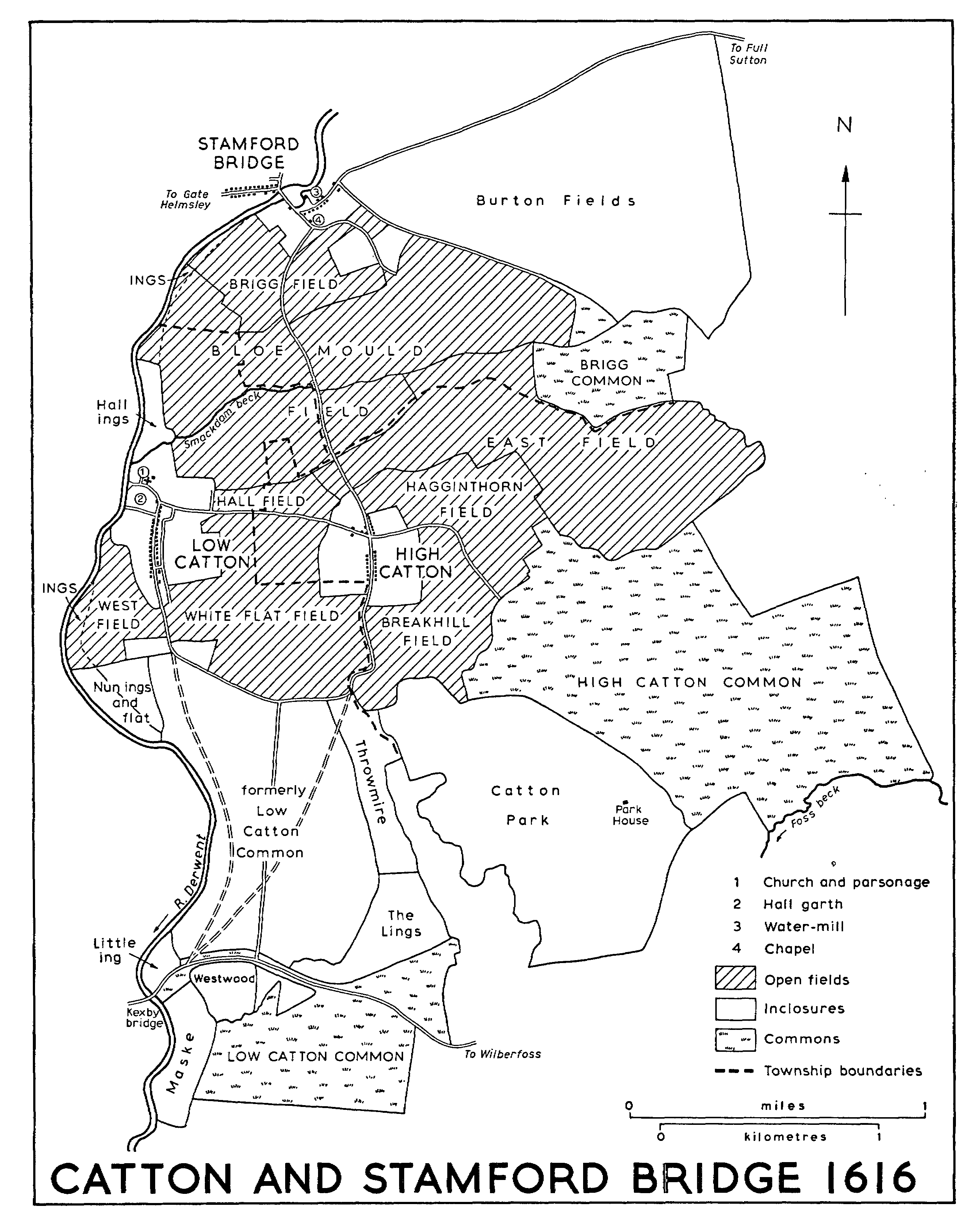
CATTON AND STAMFORD BRIDGE 1616
Much of Stamford Bridge township and the northern part of the Cattons lie at more than 50 ft. above sea-level, though lower ground borders both the Derwent and Mill Sike beck. The higher ground is continued southwards through the Cattons by the Escrick moraine, which forms a narrow ridge in places more than 100 ft. high. On either side of the moraine large areas of High and Low Catton lie at only 25-50 ft. above sea-level. The extensive open fields lay mainly on the higher ground and were inclosed in 1766. The deer park of the lords of Catton manor lay partly on the moraine but included much adjoining low ground. The rest of the low ground, on either side of the park, was occupied by High and Low Catton commons, the former inclosed with the open fields but much of the latter c. 1600.
Only limited areas of alluvium lie within the bends of the Derwent and both common and demesne meadow land was of small extent. The river formed almost the whole of the western boundary of the townships, but Stamford Bridge East township included about 2 a. of Mill ings on the west bank of the river (fn. 6) which belonged, with much of the township, to Catton manor. (fn. 7) The northern boundary of the parish follows the Roman road running eastwards from Stamford Bridge.
Most of the roads in the Cattons and Stamford Bridge are narrow winding lanes connecting the three villages or leading to neighbouring Fangfoss, Full Sutton, and Wilberfoss. Conspicuously straight roads cross the late-inclosed commons. Thus Long Lane, with its wide verges, dates from the inclosure of Low Catton common c. 1600; it replaced two roads running obliquely across the common from Kexby bridge. (fn. 8) Long Lane joins the road from Kexby to Wilberfoss, which crosses the south of Low Catton township and now forms part of the York-Hull trunk road. The latter road crosses Throwmires beck by Arnull bridge, mentioned in 1752, (fn. 9) and as it approached the Derwent it apparently crossed the stone-built 'Kexby Little Bridge', mentioned in the early 18th century. (fn. 10) The road was turnpiked in 1764 and the trust was continued until 1881; a toll bar near Kexby bridge was replaced in 1827 by one at the end of Long Lane. (fn. 11) The road was widened and straightened in the 1960s and 1970s. (fn. 12)
At Stamford Bridge the main road east of the village lies on the line of the Roman road which led directly down to the ford in the Derwent. The Roman road from York approached the ford in Stamford Bridge West. The ford was also on the line of Roman roads from the north-east and southeast, the latter running from Brough (Petuaria). The line of the south-easterly road is not followed by any modern roads in High Catton or Stamford Bridge townships. There is no evidence that the Romans replaced the ford with a bridge. (fn. 13)
It was presumably the Anglians who first built a bridge and the vill was referred to as Stamford Bridge in the Anglo-Saxon Chronicle in the description of the battle of 1066. (fn. 14) The apparently narrow timber bridge of 1066 may have been near the ford or alternatively some 150 yd. downstream, on the site of the later medieval bridge. The movement of the river crossing was perhaps due to the construction of a weir to work the water-mills and the consequent deepening of the river above the mills and creation of a pond below them. (fn. 15) It was presumably a bridge on the new site which was in need of repair in 1280 and 1282. (fn. 16) When it was in disrepair in 1362 Henry Percy, lord of Catton and Stamford Bridge, was held not to be responsible for its upkeep. (fn. 17) A bequest was made towards the repair of the bridge in 1385, (fn. 18) and grants of pontage were made for three years each in 1384 and 1391. (fn. 19) Another bequest was made in 1491. (fn. 20) The bridge had become the responsibility of the county by 1581, when townships in Buckrose wapentake were assessed to its repair. (fn. 21) It is said to have been built of timber with stone piers. It was replaced by another bridge a further 150 yd. downstream, the new site perhaps being chosen because the river was narrower there. It was completed in 1727 at the expense of the East Riding to the designs of William Etty of York. (fn. 22) It was regularly repaired by the county thereafter, (fn. 23) and in 1966-7 a steel footbridge was erected alongside. (fn. 24) The bridge, of stone, has a central segmental arch, flanked by two semicircular arches which are normally dry.
The main road crossing the bridge was turnpiked in 1765 and the trust was continued until 1872. (fn. 25) In 1812 a toll bar was situated in the village, between the bridge and the mill. (fn. 26) The road is now part of the main York-Bridlington road.
The Derwent was navigable up to Stamford Bridge in the Middle Ages but at least from 1602, when a new weir was built, the water-mill there may have prevented boats from passing further upstream. (fn. 27) The river was made navigable under an Act of 1702. (fn. 28) By the early 1720s a cut with a lock had been made on the west bank, bypassing the mill, the lock itself lying in Stamford Bridge West township. The river carried mainly coal, lime, corn, and flour, and there were stables, a warehouse, and a coalyard at Stamford Bridge, as well as a lockkeeper's house. Until 1854, when they sold it to the North Eastern Railway, the navigation belonged to the Wentworths, earls FitzWilliam, as lords of the manor of Malton. It was less used thereafter and traffic ended c. 1900; the lock and cut were described as no longer usable in 1939. (fn. 29)
The railway line from Market Weighton to York, opened in 1847, (fn. 30) crosses Stamford Bridge and High Catton townships. It was closed in 1965 (fn. 31) and the track has been lifted. The station and station master's house at Stamford Bridge, of brick with a stone portico, still stood in 1974, together with an engine shed. Near by a high viaduct across the Derwent valley consists of 15 brick arches and an iron span above the river. (fn. 32)
Low Catton village stands along a single street roughly parallel with the Derwent. From its northern end a lane runs towards the river and the church. On the other side of the manor-house site Wath Lane formerly led to the river bank where there was once a ford; (fn. 33) the lane was overgrown in 1974. The 18th- and 19th-century houses and cottages are not noteworthy, except for the former Rectory. (fn. 34) Cast-iron lamp standards beside the lane to the church commemorate the Diamond Jubilee. There are six council houses and a few other recent dwellings. An alehouse at Low Catton was licensed in the later 18th century (fn. 35) and a victualler was mentioned in 1840. The Gold Cup inn was recorded from 1851 onwards (fn. 36) and still exists. The village street of High Catton, bordered by wide grass verges, contains mainly 19th-century houses, with four council houses. There were two licensed alehouses there in the 1750s and one later in the century. (fn. 37) The Woodpecker Lass was mentioned from 1823 but apparently closed c. 1880. (fn. 38) Just south of the village one house survives at a place called Land of Nod, where poorhouses formerly stood.
The main village street of Stamford Bridge bypasses the site of the early ford and runs down to the Derwent between high-banked verges; it approaches the site of the medieval bridge before turning abruptly towards the 18th-century bridge. The layout of the approach roads and the form of the village street thus clearly reflect the successive movements of the river crossing. The former watermill still dominates the centre of the village, though part of the mill pond, known as the Shallows, has in recent years been filled and 'landscaped'. Outstanding among a variety of 18th- and 19th-century houses is that called Ashburnholme, a large twostoreyed early-18th-century building with a decorative eaves course and stringcourse and a hood over the doorway. Several buildings in the village incorporate some local Jurassic stone.
There were two or three licensed houses in Stamford Bridge in the later 18th century. (fn. 39) The Three Tuns, recorded in 1823, was not mentioned again but the Bay Horse and the New Inn, recorded in 1823 and 1840 respectively, still exist; the New Inn was renamed the Swordsman in 1974. The Jolly Sailors, mentioned in 1840, was perhaps the house known as the Hope and Anchor by 1851 and last recorded in 1892; it stood near the cut west of the river but in Stamford Bridge East township. (fn. 40) A girls' boarding school was held in the village from 1840 until the 1890s, when it was accommodated in Vine House. (fn. 41) A reading room, recorded from 1872 until 1937 and known as St. John's Room, (fn. 42) was used as a shop in 1974.
Buildings began to be erected away from the old village centre in the later 19th century. A chapel-ofease to the parish church was consecrated in 1868 on the Catton road, (fn. 43) and further south, beyond the railway station, a red-brick and slate Gothic-style mansion called Derwent Hill was built by Frederick Wright c. 1880. (fn. 44) Stamford Bridge House, on the Full Sutton road, was built c. 1900. (fn. 45) Since the Second World War extensive private and council house estates have been built south of the village and other houses were going up in 1974. Stamford Bridge House was used as an emergency isolation hospital during the same war and Derwent Hill became a county council old people's home in 1952 ; (fn. 46) a new home was built in its grounds in 1974. A village hall was built near by in 1957. (fn. 47) A stone commemorating the battle was put up at the centre of the village in 1956. (fn. 48) By 1974 ground beside the cut on the west side of the river was used as a caravan site.
The dozen outlying farms in High and Low Catton all post-date the 1766 inclosure except Catton Park, on the site of a keeper's lodge in the former deer park. (fn. 49) At Primrose Hill four bungalows have been built near the farm. The outlying houses in Stamford Bridge East include Burtonfield Hall, (fn. 50) a few farms, and a group of cottages near the former brickworks.
There were 111 poll-tax payers in 'Catton' in 1377, (fn. 51) exclusive of Stamford Bridge. About 30 houses stood in each of the Cattons in the early 17th century, (fn. 52) and 31 households in each were included in the hearth-tax return in 1672, 13 altogether being exempt. Of the chargeable households in 1672 41 had one hearth each, 4 had 2 or 3, 3 had 4, and one had six. (fn. 53) There were 94 families in Catton, presumably including Stamford Bridge, in 1743 (fn. 54) and c. 100 in 1764. (fn. 55) The population of Low Catton was 147 in 1801; it rose to 193 in 1891 but was only 135 in 1901 and 85 in 1931. High Catton had 181 inhabitants in 1801, rising to a maximum of 221 in 1831, but falling to 146 in 1901. In 1931 there were 174. The combined population of the two villages was 277 in 1951 and 266 in 1971. (fn. 56)
At Stamford Bridge East and Hundburton 62 people paid the poll tax in 1377. (fn. 57) In 1604-5 27 deaths occurred from the plague. (fn. 58) There were about 15 houses in the early 17th century (fn. 59) and 18 households in 1672, 4 of them exempt from hearth tax; of those chargeable 8 had one hearth each and 6 had 2 or three. (fn. 60) The population was 170 in 1801, rising to 298 in 1821 and a maximum of 417 in 1861, and standing at 394 in 1901. After falling to 315 in 1921 it rose to 395 in 1931. After Stamford Bridge was enlarged by the transfer of part of Stamford Bridge West, with 32 inhabitants in 1931, the population rose to 577 in 1951, 674 in 1961, and 1,206 in 1971. (fn. 61)
MANORS AND OTHER ESTATES.
In 1066 the manor of Catton together with its extensive soke comprised 40 carucates, of which possibly 12 were in Catton itself and Stamford Bridge. It then belonged to Earl Harold and in 1086 it was held by William de Percy of Hugh, earl of Chester. (fn. 62) CATTON manor was subsequently held by the Percies in chief, as of the honor of Chester. (fn. 63)
The Percies' enjoyment of the manor was interrupted by the forfeiture for rebellion of the possessions of Henry Percy, created earl of Northumberland, (fn. 64) and Catton was consequently granted in 1405 to the king's son John. (fn. 65) In 1416, however, the property was restored to Henry Percy, earl of Northumberland (d. 1455) (fn. 66) and retained by the family until 1537, when Henry Percy, earl of Northumberland (d. 1537) surrendered it to the Crown with the rest of his northern estates. (fn. 67) In 1555 the manor was granted for life to Mary, the same earl's widow, and two years later a reversionary grant of the property was made to Thomas Percy, earl of Northumberland (d. 1572). (fn. 68)
The manor descended in the family until the death of Joceline Percy, earl of Northumberland, in 1670, when it passed to his daughter Elizabeth; she in 1682 married Charles Seymour, duke of Somerset (d. 1748). On the death of Algernon Seymour, duke of Somerset, in 1750 his unentailed estates, together with the titles earl of Egremont and Baron Cockermouth, passed to his nephew Sir Charles Wyndham. When George Wyndham died in 1837 his East Riding estates passed to his illegitimate son George, who was created Baron Leconfield in 1859. (fn. 69) The Catton and Stamford Bridge estate comprised about 2,000 a. in 1897. (fn. 70) It was split up and sold in separate lots by Charles Henry Wyndham, Lord Leconfield, mainly in 1920-1. (fn. 71) The manorial rights in Stamford Bridge were sold to John Hetherton in 1923. (fn. 72)
The manor-house, which stood immediately south of the church at Low Catton, was apparently moated in 1258-9. (fn. 73) It was mentioned in 1315 and 1352, (fn. 74) but in 1577 it was described as 'so utterly ruinated . . . that [it] hardly can be judged where [it] hath stood'. A house 'in the side' of Hall garth was said to be used as the court house. (fn. 75) There is no later mention of a manor-house but some traces of earthworks remain.
That part of Stamford Bridge East sometimes called Hundburton and later Burton Fields was held separately under the Percys. In 1284-5 3 carucates at 'Burton' were held by Thomas Burdon, or Burton, lord of Kexby, (fn. 76) and in 1316 Brian Burdon and Eleanor Percy were lords of Hundburton. (fn. 77) Until the 17th century the descent is obscure. Hundburton apparently belonged, like Scoreby, to the Nevilles. The manor of 'Burtonfield' was referred to after the death of Richard Neville in 1460, (fn. 78) and Edmund Neville conveyed HUNDBURTON manor to William Watkinson the elder and his sons in 1611. (fn. 79) At his death in 1614 William Watkinson the younger devised the estate to his wife for life and then to his daughter Anne, wife of Edward Payler. (fn. 80) It later passed to Sir W. P. Payler, to his son Watkinson Payler, and then to Watkinson's daughter Mary. In 1758 Mary Payler's trustees conveyed Burton Fields to H. B. Darley, who promptly sold it to Robert Bewlay; it then comprised Burton House and 509 a. of closes. (fn. 81)
At Bewlay's death in 1781 the estate passed to one of his executors, Timothy Mortimer. (fn. 82) By 1810 it belonged to Charles Mortimer, and in 1833 it was bought by Henry Darley. (fn. 83) By 1840 it had passed to C. A. Darley (d. 1887), whose trustees in 1889 sold 169 a., later called Hill farm, to Thomas Coates and 283 a., called Burtonfields farm, to John Kirby. (fn. 84) Coates acquired Kirby's farm in 1895, and the Coates family sold all 452 a. to John Sherbourne in 1922. (fn. 85) The farms were sold in separate lots by Ronald Sherbourne in 1965. (fn. 86)
In 1840 the estate included Burtonfield House 'lately erected' by C. A. Darley. (fn. 87) The house, then known as Burtonfield Hall, and 64 a. were sold by William Darley to W. M. Harrison in 1896, and in 1917 Harrison devised them to George Laver and Reginald Bush. (fn. 88) The Bush family still owned them in 1973. The house is a large and irregularly-planned villa standing in a small park.
A little land in Catton was, like Scoreby, Stamford Bridge West, and Hundburton, in the king's hands in the 1490s and was accounted for along with Sheriff Hutton. (fn. 89) It was perhaps this land which comprised the 37 a. said c. 1602 to have been lately bought by the Percies from the 'duchy of York', (fn. 90) presumably property enjoyed by a royal duke of the 15th century.
Several small estates at Catton belonged to religious houses. Nun Appleton priory had 2 bovates in 1284-5. (fn. 91) Byland abbey was given 60 a. and more, together with pasture for 400 sheep, by William de Percy; (fn. 92) the former Byland holding amounted to about 120 a. c. 1602. (fn. 93) The Knights Templars had a carucate in Catton in 1284-5 (fn. 94) and the Knights Hospitallers a bovate; (fn. 95) the Hospitallers' property was briefly restored to them in 1558, (fn. 96) and it was in the hands of the Crown c. 1602, when it comprised about 30 a. (fn. 97) Sawley abbey was given a carucate in Catton by Maud de Percy c. 1180. (fn. 98) St. Peter's hospital, York, had 2 bovates in the parish, (fn. 99) and Wilberfoss priory had a like amount in 1284-5. (fn. 100) In 1539 the former Wilberfoss estate comprised a house and about 40 a. in Catton and a house in Stamford Bridge. (fn. 101)
ECONOMIC HISTORY.
Catton itself cannot be separated from its extensive soke in the Domesday Survey. The whole soke contained land for 24 ploughs, and in 1086 there was one plough in demesne, perhaps in Catton, and 17 ploughs held by 32 villeins and 6 sokemen. With a mill and woodland two leagues long and one wide the estate had been worth £28 in 1066; in 1086 its value was only £5. (fn. 102)
Subsequent reclamation from waste and wood may be glimpsed in the early mention of a tenant's assart (fn. 103) and in the 77 a. of forland belonging to the manor in 1315. Medieval extents of the manor of Catton apparently included the soke in Stamford Bridge and in the adjoining townships of Full Sutton, Newton, and Wilberfoss, all on the east side of the Derwent. On the west bank, however, Kexby, Scoreby, and Stamford Bridge West were all held separately from Catton. The Catton demesnes included 227 a. of land in 1258-9, (fn. 104) 132 a. in 1315, (fn. 105) and 120 a. in 1352, (fn. 106) together with about 30 a. of meadow on each occasion. In 1258-9 there were 180 a. of woodland, and pasture in the woods was recorded in 1315; it was probably there that the Percies made their park, first expressly mentioned in 1352 with its beasts, herbage, and underwood. The making of the park may perhaps be seen in an agreement made between Richard de Percy and various inhabitants in the 13th century whereby the latter gave up their claim to common in 'Lund subtus Brek', (fn. 107) that is the wood lying below the breck (later Breakhill field).
Much land was held by tenants. In 1258-9 free tenants held 39 bovates and two tofts, cottagers 23 tofts and 6 a. of land, and bondmen 14 bovates; their rents totalled about £12. In 1315 rents amounted to £19, and the holdings in bondage were described as 196 a. of land and 6 a. of meadow; villeins' works were then worth £2. Rents were valued at a similar figure in 1352, but the total value of the manor had fallen from £50-55 at the earlier dates to about £40, and a further indication of the decline perhaps resulting from the Black Death was the lack of tenants which left 18 bovates lying waste.
Catton manor and soke were worth about £66 in the 15th century (fn. 108) and £72 in 1539-40. (fn. 109) At the latter date, and no doubt much earlier, the demesnes were farmed out and accounted for £15 of the bailiff's charge. Tenants' rents made up about £30, commuted works were worth £2, and Stamford Bridge mills (fn. 110) were let for £24. The herbage of the park was farmed, too, but 3 a. of meadow were reserved for the upkeep of the beasts there and the park lodge was repaired that year.
By the later 16th and early 17th centuries (fn. 111) there were over 1,200 a. lying in the open fields around the villages of High and Low Catton and Stamford Bridge. Individual field names were mentioned in 1577, and in 1616 there were 44 a. in Hall field, 175 a. in White Flat field, 88 a. in West field, 107 a. in Breakhill field, 94 a. in Hagginthorn field, 318 a. in East field, 356 a. in Bloe Mould field, and 89 a. in Brigg field. Piecemeal inclosure of open-field land was recorded in 1577, when freeholders were alleged to keep small parcels amounting to about 18 a. inclosed, and the field acreages of 1616 included 105 a. of closes. Brigg field lay entirely in Stamford Bridge, Bloe Mould and East fields partly there and partly in the Cattons, and the other fields entirely in High and Low Catton. It is not known how the fields were divided for the purposes of rotation, but c. 1602 a parcel of meadow and a small close were said to lie in the fallow field every third year. Small areas of meadow near the Derwent were reckoned as part of the open fields: they amounted to 13 a. in West, 7 a. in Bloe Mould, and 9 a. in Brigg fields in 1616. About 150 a. of open-field land were in demesne, comprising almost all of Hall field and 50-60 a. each in White Flat and Bloe Mould fields, where some of it formed whole flats, or furlongs.
Beyond the open fields lay common pastures said in 1577 to amount to about 1,000 a., equally divided between West and East moors or commons. The inhabitants of neighbouring villages were granted rights in the commons by Richard de Percy in the 13th century in return for giving up a claim to common in 'Lund subtus Brek', but Wilberfoss men were exceeding those rights in the later 16th century. (fn. 112) In 1616 East moor apparently comprised 536 a., including Full Sutton common; within it were Brigg Doles or common (93 a.), mainly in Stamford Bridge, and Whinberry Hills (64 a.), partly in Wilberfoss. High Catton had sole right of common in 185 a., Wilberfoss shared Whinberry Hills, and High Catton, Stamford Bridge, and Full Sutton intercommoned in the rest. A small part of East moor was set aside as the Cow Hold. Much of West moor appears to have been inclosed in the early 17th century and only about 170 a. remained in 1616. It was used chiefly by Low Catton, but Newton upon Derwent had rights in about half of the remaining common. The area recently inclosed comprised about 440 a. in 1616, apparently including grounds known as Throwmire and the Lings. Other grounds, once part of West Moor, were already inclosed by 1570: they included the Maske or Marsh (38 a.) and Little ing (10 a.), beside the Derwent, and Westwood (22 a.); all were held in demesne, as was Hall ing (16 a.), beside the river near Low Catton village. In addition, Old Hagg was a 40-acre old inclosure which had been restored to the common.
The Percies' park lay between East and West moors and contained over 350 a. In 1577 it included seven groves and there was still a keeper's lodge, but the pale was greatly decayed; only 24 deer were left in it and the herbage was let. Between 1577 and 1601 1,055 oaks and much smaller timber were taken from the park and from Westwood, and either sold or used for repairs to Stamford Bridge and Thornton mills, the court house at Catton, (fn. 113) and the park lodge and pale. One of the former groves was converted to an arable close in 1602 on condition that the tenant should plant the pale and other inclosures in the park with quickwood. By 1616 the park was divided into a dozen closes and the lodge was known as Park House.
In the late 16th century freeholders formed a large group of tenants in High and Low Catton and Stamford Bridge, holding 13 houses in 1570 and 25 houses and cottages in 1577. At the latter date the largest freeholds were one of 6 bovates and one of 78 a. There were also 25 customary tenants and 11 cottagers in 1570, and 36 tenants-at-will in 1577. Twenty-two of the tenants-at-will had under 10 a. each, 4 had 10-19 a., and 10 had 20 a. or more, the largest holding amounting to 39 a. Most of the holdings consisted of open-field arable land, small parcels of meadow, garths and crofts, and a common right. Former labour services were represented by the payment of 'boon silver' by 36 tenants.
By c. 1602 freeholders in the two Cattons and Stamford Bridge held 26 houses and cottages and 555 a. of land, including the rectorial glebe. Tenants-at-will held 42 houses and 522 a.; 25 of them had holdings of under 10 a. each, 4 had 10-19 a., and 13 had 20 a. or more. In 1616 there were 22 freeholders with 658 a. of land, 9 of them holding under 10 a. each, 3 with 10-19 a., 3 with 20-29 a., and 7 with more. The largest freeholds were one of 90 a., belonging to Christopher Beamond, (fn. 114) and another of 133 a. In the same year there were 38 tenants-atwill with 573 a. of land, 21 holding under 9 a. each, 2 with 10-19 a., 4 with 20-29 a., and 11 with more, the largest holdings comprising 40 a. and 43 a. Most of the holdings included arable land in two or more of the open fields and some had small parcels of meadow as well.
Besides the open fields and commons which were shared with the other townships in the soke, Stamford Bridge included the lands of the manor of Hundburton. There is no evidence to show whether a village community ever existed there, but it is possible that the Burton fields or Burton closes referred to from the late 16th century (fn. 115) onwards occupied the former open fields of Hundburton. Burton closes comprised about 500 a. (fn. 116) To the west of them lay Ox close, which covered 76 a. in 1758 when it was still used as a stinted pasture by the occupiers of lands in both Burton fields and Skirpenbeck. (fn. 117)
The remaining open fields and commons within the soke of Catton were inclosed in 1766, (fn. 118) under an Act of 1760. (fn. 119) Allotments were made totalling 1,416 a. from fields and commons, and a further 1,261 a. of old inclosures were also allotted. The earlier open fields had by then been subdivided, several of the new names having been already used in the early 17th century for parts of the fields. Allotments were made from the following fields: Furlong (156 a.), Far (113 a.), Blow Mould (75 a.), Reckon Dale (30 a.), Hagginthorn (27 a.), Breckhill (23 a.), Merrill Thorn (22 a.), Dock Flat (18 a.), Brigg (14 a.), Angram (10 a.), Half Acre (9 a.), and Cross Lands (7 a.). Allotments comprising 591 a. were made from High Catton common (i.e. East moor), 215 a. from Low Catton common (i.e. West moor), and 100 a. from Stamford Bridge common, together with 6 a. in Cow Lane, the outgang which had led to the common from Stamford Bridge village.
While some men received allotments consisting entirely of land from the open fields and commons, others had their former open-field and common rights satisfied wholly or partly by the allotment of old inclosures. Thirty-two men received allotments of one kind or another. The largest allotment, of 1,507 a., went to the earl of Egremont, and the rector received 270 a. for glebe and tithes. There were 4 allotments of 100-150 a., 2 of 50-99 a., 3 of 20- 49 a., 5 of 10-19 a., and 16 of under 10 a. The inclosure commissioners were not concerned with that part of Stamford Bridge lying outside the soke of Catton, but probably the only man with a considerable holding there was the owner of Burton Fields.
The Egremont estate in Catton and in the adjoining townships of the soke comprised 2,870 a. in 1797 and there were 60 tenants, large and small. Only 10 tenants had 100 a. or more, and 12 had 50- 99 a. (fn. 120) In 1851 17 farmers in the Cattons and Stamford Bridge had 100 a. or more. (fn. 121) The total number of farmers there was usually 20-30 in the 19th and 20th centuries, a dozen of whom had 150 a. or more in the 1920s and 1930s. (fn. 122) Garden allotments for the poor of Stamford Bridge were provided by C. A. Darley c. 1840. (fn. 123) There was much grassland in some parts of these townships after inclosure. Thus at Stamford Bridge in 1795 there were 363 a. of arable and 737 a. of grassland, (fn. 124) and in 1905 751 a. of arable, 384 a. of grassland, and 4 a. of woodland. In the Cattons in 1905 there were 1,802 a. of arable, 953 a. of grassland, and 76 a. of woodland. (fn. 125) Grass was still plentiful in the Burton Fields area of Stamford Bridge and alongside the Derwent in the Cattons in the 1930s and later. (fn. 126) There were two large turkey farms at Catton in 1974. The chief area of woodland is the 43-acre Black plantation, in High Catton, which has been managed by the Forestry Commission since 1959. (fn. 127)
A fishery in the Derwent was frequently mentioned as an appurtenance of Catton manor from 1258-9 (fn. 128) onwards. Fishing there was said to obstruct the passage of boats up to Stamford Bridge in the 14th century. (fn. 129) There was a landing-place near the church at Low Catton in 1616, (fn. 130) and the improvement of the Derwent in the 18th century (fn. 131) was doubtless of benefit to both Catton and Stamford Bridge. At the latter there was a 'mariner' in 1840 and a waterman in 1851. (fn. 132)
The growth of Stamford Bridge in the 19th century led to an increase in the numbers of shopkeepers and tradesmen there, and garages and refreshment rooms have appeared in the 20th century. (fn. 133) Otherwise, the chief non-agricultural employment has been provided by brick-making, quarrying, and milling. Brick-making in Catton, near the present Moorfield (formerly Brickworks) Farm, was recorded from 1840 and at Stamford Bridge, near Beechwood House, from 1823, in each case until the 1870s. (fn. 134) Gravel pits were worked commercially in High Catton, close to the village street, in the 1930s and later, and at Stamford Bridge, in the Burton Fields area, from the 1920s. (fn. 135) All were disused in 1973. In 1850 (fn. 136) there was a chicory kiln near the brickyard at Stamford Bridge, still standing in 1973, and a warehouse and maltkiln in Catton, demolished when Kexby bridge was rebuilt in the 1960s.
The mill recorded under Catton in 1086 (fn. 137) may have been at Stamford Bridge. There was, however, a small water-mill in Catton itself, apparently that described in 1258-9 as 'sometimes grinding in winter'. (fn. 138) It was probably the fulling mill called Beck mill that was mentioned in 1474. (fn. 139) It stood in Smackdam close, on Mill Sike beck north of Low Catton village, (fn. 140) and had been demolished by c, 1602. (fn. 141) Mills certainly existed at Stamford Bridge by c. 1130-5, (fn. 142) and they consisted of 'seven mills on one pond in the Derwent' in 1258. (fn. 143) A new fulling mill was mentioned in 1331, (fn. 144) and in 1352 the mills comprised three corn and two fulling mills. (fn. 145) Both corn and fulling mills were frequently recorded thereafter (fn. 146) and the various 'mills' may have been housed from the first in buildings on both banks of the river. In the later 16th century there were two corn mills and one fulling mill on each bank, but in 1602 they were taken down and rebuilt on the southeast bank and at the same time a stone dam or weir was built. (fn. 147) Soon afterwards they were described as five corn and two fulling mills 'all under a roof'. (fn. 148) In 1797 the mills contained three water-wheels and five pairs of stones for corn, and one water-wheel in an attached fulling mill; a second, adjoining, fulling mill was in a different tenancy. (fn. 149) The second fulling mill was apparently that belonging to a dyer who was in dispute with the corn-miller in 1715; (fn. 150) a dye-house near the bridge was recorded in 1724. (fn. 151) The mills were burnt in 1749 but repaired the following year. (fn. 152) When the York to Garrowby Hill turnpike trust was renewed in 1807 the earl of Egremont and his tenants were exempted from toll on traffic to and from the mills, (fn. 153) though their exemption was in dispute in 1812. (fn. 154) A small bleaching or 'beetling' mill (presumably the former separate fulling mill) stood near the mills in 1812. (fn. 155) Nearly £1,000 was spent on the mills in 1847-50, (fn. 156) and it was perhaps then that the building was enlarged. There were subsequently two waterwheels and seven pairs of stones, and the mill was worked until 1964; it was converted into a restaurant in 1967, but some of the machinery remains. (fn. 157) The building consists of an 18th-century block with steep-pitched roof and an adjoining five-storeyed 19th-century block, with a lower projection towards the west. (fn. 158)
LOCAL GOVERNMENT.
The profits of manorial courts at Catton were recorded from 1258-9 onwards, (fn. 159) and there are many surviving court rolls for the manor and soke from the late 15th to the late 17th century, (fn. 160) as well as court books and call rolls for the period 1806-72. (fn. 161) The bailiffs at Stamford Bridge, presumably acting for the lord of Catton, claimed the right to take tolls and measurage in 1275-6. (fn. 162) Liberties claimed as appurtenant to the manor in 1616 included the right to take waifs, strays, escheats, and forfeitures, and the goods of felons, fugitives, and outlaws. (fn. 163) A house 'in the side' of Hall Garth was used as the court house in 1616. (fn. 164) This, the so-called 'Hall House', later became the Rectory. (fn. 165)
Officers elected in the 1470s were a constable for each of High and Low Catton, Stamford Bridge, Hundburton, and Kexby Bridge, and an aletaster for each of the Cattons and Stamford Bridge. (fn. 166) In the 1660s a constable was elected for each of the Cattons, and a constable and a bylawman for Stamford Bridge. (fn. 167) In the 19th century a constable, deputy constable, four bylawmen, and a pinder were appointed for each of High Catton, Low Catton, and Stamford Bridge townships. (fn. 168)
No parochial records before 1835 are known. There were parish poorhouses at Stamford Bridge (fn. 169) and at a place called Land of Nod, south of High Catton village. (fn. 170) The Cattons and Stamford Bridge joined Pocklington poor-law union in 1836 (fn. 171) and Pocklington rural district in 1894. (fn. 172) They became part of the North Wolds district of Humberside in 1974.
CHURCH.
Catton church was mentioned in the early 13th century, when parochial rights were granted to its dependent chapel at Full Sutton. (fn. 173) There were also chapels at Kexby and Stamford Bridge, both of which may have been suppressed as chantry chapels in the 16th century. Churches were built there in the 19th century and Kexby became a separate parish in 1853. (fn. 174)
The Percies presented to Catton rectory in 1268 (fn. 175) and the advowson descended with the manor until the 17th century. (fn. 176) It was said in 1577 to belong to William Stanley, Lord Monteagle, (fn. 177) and the Crown presented, presumably by lapse, in 1578 and 1592. (fn. 178) There were unexplained presentations in 1678 by Sir William Pierrepont and Sir Orlando Gee and in 1685 by Gee alone. (fn. 179) By an exchange of 1692-3 the advowson passed from the duke of Somerset to the Crown, (fn. 180) which presented in 1739 and 1755. (fn. 181) The earls of Egremont later laid claim to the advowson by virtue of a settlement of 1687 whereby it was to pass to the heirs of Elizabeth, duchess of Somerset. They successfully disputed the Crown's right of presentation in 1786-7 and 1814. (fn. 182) Thereafter the advowson descended with the manor and in 1972 belonged to Lord Leconfield's trustees. (fn. 183)
The church was worth £40 in 1291, (fn. 184) £21 12s. 8d. net in 1535, (fn. 185) and £116 16s. 8d. net in 1650. (fn. 186) The average net value was £410 in 1829-31, (fn. 187) and the income was £500 in 1884 and £390 in 1915. (fn. 188) Tithes provided £21 of the gross income in 1535, £8 coming from Kexby and Scoreby. (fn. 189) There were several disputes over their payment in the 16th and 17th centuries. (fn. 190) In 1650 moduses of over £10 were paid in lieu of tithes in the townships, (fn. 191) and in 1716 moduses totalled over £15, comprising over £4 from Kexby, about £2 10s. from Scoreby, £1 10s. from Burton Fields, nearly £2 from Scoreby Grange, over £1 from Stamford Bridge mills, nearly £2 from certain ancient inclosures in Catton, and £1 13s. 4d. from the rector of Full Sutton. (fn. 192) At the inclosure of Catton in 1766 the rector received allotments of 270 a. for his glebe and tithes, but most of the moduses remained payable. (fn. 193) The moduses from Scoreby and Scoreby Grange were apportioned as rent-charges in 1841 and those from Catton, Kexby, and the mills in 1843. (fn. 194)
Glebe land contributed £1 to the gross income in 1535. (fn. 195) In the 17th century the rector had about 60 a. of open-field land, two parcels of meadow, and a 20acre close, making a total of 87 a. in 1728. (fn. 196) The land allotted at inclosure in lieu of glebe and tithes comprised White House and Glebe farms; the two farms, amounting to 266 a., were sold in 1920. (fn. 197)
A house belonging to the rector was said in 1539 to have been let to the countess of Northumberland. (fn. 198) It stood close to the church in 1616, (fn. 199) and was recorded among the property of the rectory from 1663 onwards. (fn. 200) During the rector's non-residence the curate lived in the 'parsonage' in 1743. (fn. 201) The house was described as ruinous but about to be rebuilt in 1818 (fn. 202) and as unfit for residence in 1835. (fn. 203) It was presumably the present Glebe Farm, of which part of the south front and staircase remain from a substantial house of c. 1700 which has been curtailed on the north and completely remodelled in the earlier 19th century.
In 1764 the curate lived in the 'Hall House' (fn. 204) and at in closure in 1766 the rector was awarded the Hall House by exchange, as well as a house that was presumably the old Rectory. The Hall House stood in the angle of the village street and Church Lane, in Hall Garth, (fn. 205) and was formerly the court house of the manor. (fn. 206) It was described as the Rectory in 1851. (fn. 207) It was sold in 1957 (fn. 208) and replaced by a new Rectory near the church at Stamford Bridge. The central part of the east front of the old house retains internally some heavy timbers and a roof structure which may date from the 16th or early 17th century. The house was extended to the north later in the 17th century and both parts were refronted in brick in the 18th century. In the later 19th century the house was enlarged on the south, where the new work may replace part of the early range, and on the west.
An obit in the church was endowed with land in Full Sutton, which was granted by the Crown to Francis Barker and Thomas Blackway in 1566. (fn. 209)
There was a chapel, with a hermit, at Stamford Bridge in 1348. (fn. 210) In 1444 a chapel there was described as on the bridge, (fn. 211) and in 1466 a chapel of St. Edmund was mentioned. (fn. 212) It was probably suppressed as a chantry chapel in the 16th century. Materials from the building had been sold by 1556 (fn. 213) and it was in decay in 1575. (fn. 214) A chapel of St. Leonard was, however, shown on a map of 1616 beside the Catton road, just south of the village street. (fn. 215) It was presumably that building which the inhabitants of Stamford Bridge claimed in 1598 to be served by a curate who took the tithes of the township for his stipend and provided all services but burial. The claim was disputed by the rector. It was decided by the chancellor of York that the rector himself or a curate should say a weekly service at Stamford Bridge and should baptize and marry there, and that the 'better and more able sort' of the inhabitants should hear service in the parish church eight times a year; the rector was to take the tithes of Stamford Bridge. (fn. 216) The matter was still in dispute in the 1630s. (fn. 217) The chapel presumably stood in the 'chapel garth' which belonged to the rector in 1716 and later, (fn. 218) and remains of the chapel are said to have been visible there in 1861. (fn. 219) Lands in Catton, formerly belonging to a chapel, which were granted to Francis Barker and Thomas Browne in 1571, (fn. 220) may have supported the Stamford Bridge chapel.
The living was often held in plurality by a nonresident rector. In 1308 Walter de Bedwind also held Aughton and three other churches, a prebend at Howden, the deanery of Tamworth (Staffs.), and the treasurership of York Minster. (fn. 221) The rector was granted a dispensation to hold more than one living in 1428. (fn. 222) In 1574 he resigned and became a fugitive papist. (fn. 223) In 1743 he was also vicar of Askham Richard, where he lived, and curate of Bilbrough (both Yorks. W.R.), (fn. 224) and in 1764 he held Scrayingham and Stockton on the Forest (Yorks. N.R.), and was master of the grammar school at York, where he lived. (fn. 225) In 1835 the rector was also vicar of Wressle and held St. Buryan (Cornw.). (fn. 226)
A parish chaplain, with an income of £4 13s. 4d., was recorded at Catton in 1525-6, (fn. 227) and there was an assistant curate in 1743, 1764, 1835, 1892, and 1900. (fn. 228)
Two services were held at Catton each Sunday in 1743 and Holy Communion was celebrated five times a year, with about 140 communicants the previous Easter. (fn. 229) Communion was received by 60- 80 people in 1764; about 15 people received monthly in 1865 and fortnightly in 1868. A Friday and a Sunday service were held at Stamford Bridge in 1865 in a 'service room' (fn. 230) and in 1868 in the newlybuilt chapel. There were three Sunday services each week at Catton in 1884 and two in 1894. Communion was celebrated there each week by 1915. (fn. 231) There was one service each week in 1973 at both Catton and Stamford Bridge.
The church of ALL SAINTS, Catton, of ashlar and rubble, consists of chancel with north vestry, aisled nave with north transept, south porch, and south-west tower. By the early 13th century the church had, in addition to the nave and chancel, at least a north aisle and transept with a combined length of four bays. A south aisle, with a tower in its western bay, was added later in the 13th century. The only remaining evidences of change in the earlier 14th century are the west window of the north aisle and the north window of the transept, but the chancel may have been heightened and refenestrated at about that time. The tower was strengthened and its upper part completely rebuilt in the 15th century, the south aisle was extended a few feet to the east and refenestrated, and the north aisle was rebuilt. Later but in a similar style the walls of the transept were raised, a new window was put into the east wall, and the roof pitch was lowered.
The church walls and roof were described as ruinous in 1676. (fn. 232) The nave was restored by Henry Gardiner, rector 1859-64, and the chancel by his sisters in 1866, under the direction of G. E. Street. The new chancel east window is by William Morris. (fn. 233) Extensive repairs were apparently done under a faculty of 1908. (fn. 234) The north aisle contains a brass to Thomas Teyll (d. 1591) and a Royal Arms dated 1723.
There are three bells: (i) 1681, Samuel Smith the elder of York; (ii) 1742; (iii) 1719, both by E. Seller of York. (fn. 235) The plate includes two silver cups, a silver salver, and base metal chalice and paten. One cup was made in London in 1617, (fn. 236) the other by John Thompson of York in 1636; one of them may have been that given, with a cover, by William Headlam in 1679. (fn. 237) The salver was made by Mark Gill of York in 1681 and given by Margaret Headlam the following year. (fn. 238)
The churchyard was enlarged in 1863 (fn. 239) and 1927. (fn. 240)
Thomas Chapman in 1750 gave £1 to the church, the interest to be given to the three best bell-ringers ringing on Christmas Day. The charity was administered with several others in 1824 and 1s. was paid to the ringers. (fn. 241) No more is known of it.
A new chapel-of-ease was consecrated at Stamford Bridge in 1868. (fn. 242) The chapel of ST. JOHN, of yellow sandstone with limestone dressings, was designed by G. Fowler Jones in the Early English style and erected partly at the expense of C. A. Darley of Burtonfield Hall. (fn. 243) It consists of chancel with north vestry and nave with bellcot and north porch. There are two bells. The plate includes a silver paten, made in London in 1864. (fn. 244) The churchyard was enlarged in 1936. (fn. 245)
The registers of baptisms, marriages, and burials for the whole parish begin in 1592 and are complete. (fn. 246)
NONCONFORMITY.
A few recusants and noncommunicants were reported at Catton and Stamford Bridge in the late 16th and early 17th centuries, and up to a dozen in the late 17th and early 18th centuries. (fn. 247) There were three Roman Catholic families in 1764. (fn. 248)
Wesley preached at Stamford Bridge in 1753. (fn. 249) About 25 Methodists were reported in the parish in 1764, but a former meeting-house at Stamford Bridge was then said to be disused. (fn. 250) The Methodists had 4 members at Catton in 1789, rising to about 30 in the early 1800s, and 8 at Stamford Bridge in 1789, rising to about 20 in the 1790s. (fn. 251) Houses were registered for worship at 'Catton' in 1764, 1779, 1787, and 1799, (fn. 252) at High Catton in 1796 and 1812, (fn. 253) and at Stamford Bridge in 1781 and 1820. (fn. 254)
A Methodist chapel is said to have been built at Stamford Bridge in 1796 and later enlarged, (fn. 255) and a chapel there was certainly registered in 1818. (fn. 256) The chapel was rebuilt in 1828 (fn. 257) and was still used in 1973; it is a large two-storeyed brick building with round-headed windows. A Wesleyan Methodist chapel was built at High Catton in 1810 (fn. 258) and replaced by a new one in 1900; (fn. 259) it was still used in 1973. The Wesleyans met in a house at Low Catton in 1851. (fn. 260)
The Primitive Methodists met in houses at High Catton and Stamford Bridge in 1851. (fn. 261) They built a chapel at High Catton in 1856. (fn. 262) It is said to have closed in 1933 (fn. 263) but was still standing in 1973. A Primitive Methodist chapel at Stamford Bridge was registered in 1868. (fn. 264) It had closed by 1935 (fn. 265) and was used as a store-house in 1973.
EDUCATION.
There was an unendowed school at Catton in 1743 with more than 30 children, (fn. 266) and in 1764 it was reported that a schoolmaster was occasionally hired and retained. (fn. 267) One of the schools existing in the parish in 1819 (fn. 268) was probably in Catton township, and there was a school at High Catton in 1835. (fn. 269) Thereafter the school was at Low Catton. It was built in 1841 by Col. George Wyndham (fn. 270) and had about 35 children in 1865. (fn. 271) It may have been temporarily closed, for in 1871 it was said that a school was then being provided at Low Catton, while High Catton children went to Stamford Bridge. (fn. 272) Low Catton National school first received an annual government grant in 1874-5. (fn. 273) From 1906 onwards 20-30 children attended the school, and when it was closed in 1923 (fn. 274) they were transferred to Stamford Bridge. (fn. 275) The school was thenceforth used as a meeting-room. It was temporarily reopened to cater for evacuees in 1939, (fn. 276) and in 1955 it was converted to a village hall. (fn. 277)
A school at Stamford Bridge was founded by Christopher Wharton, who by will dated 1787 bequeathed £600 to support a master to teach 18 children. The school was built in 1795 with the accumulated interest. (fn. 278) Two of the schools existing in the parish in 1819 may have been at Stamford Bridge, (fn. 279) and in 1835 there were three schools: Wharton's had 56 children, including the 18 taught free, and the others had 24 and 18 respectively. (fn. 280) The endowment was represented by £630 stock in 1840. (fn. 281) The school was united to the National Society and the average attendance in 1871 was 48; the endowment income was then £19 and the school was said to have been 'built' that year, (fn. 282) presumably a reference to the extension that still stands in front of the older building. An annual government grant was first received in 1875-6. (fn. 283)
A new school was opened in 1911 (fn. 284) on the Low Catton road near St. John's church. Until the 1920s the average attendance was usually 60-70, in the 1930s 70-80. (fn. 285) In 1951 senior pupils were sent to Fulford, and in 1955 they were transferred to Pocklington. (fn. 286) The school was enlarged in 1967 (fn. 287) and the attendance in September 1973 was 162. (fn. 288) Under a Scheme of 1923 the income of Wharton's charity is widely applied on behalf of local children, including payments for other than elementary education. (fn. 289)
CHARITIES FOR THE POOR.
Thomas Wood, by will dated 1568, devised a rent-charge of £10 from an estate at Kilnwick Percy for the benefit of the Cattons, Stamford Bridge, and many other townships. In 1824 3s. 4d. was distributed in High Catton, 3s. 4d. in Low Catton, and 1s. 6d. in Stamford Bridge East. (fn. 290) Henry Frederick, Baron Hotham, owner of the Kilnwick Percy estate, redeemed the rent-charge in 1961 and £7 stock was subsequently assigned to each of the Cattons and £3 to Stamford Bridge. (fn. 291) The combined income for the three townships in 1972-3 was 40p; it was not used that year. (fn. 292)
It was said in 1824 that a total of £10 had been given by unknown donors. (fn. 293) The donors were probably George Smeton (£1 in 1617), Richard Cook (5s. in 1622), William Ellard (10s. in 1622), Elizabeth Pearson (£1 in 1630), John Loftsome (10s. in 1641), Wilfrid Lazenby (£1 in 1642), Thomas Cowling (10s. in 1644), Francis Constable (£3 in 1668), Tristram Lecke (£1 in 1673), Christopher Horsley (£1 in 1670), and Richard Davy (£1 in 1685). (fn. 294)
At unknown date Hammond, William, George, and Margaret Dealtry gave £13 to the poor of the parish, including £8 to High Catton and £2 10s. to Low Catton. Land was bought, and 1½ a. was allotted to the charity at inclosure in 1766. The income was £1 15s. in 1824. (fn. 295)
Richard Gell, by will dated 1712, gave 3s. a year out of Nun ings to the poor of High Catton. The rent-charge was transferred to other land at inclosure in 1766 and was distributed with the Dealtrys' charity in 1824. (fn. 296)
William Headlam, before 1753, gave 1s. a week out of his estate in Kexby to be distributed in bread to the poor of the parish. In 1824 fourteen penny loaves were distributed weekly. (fn. 297)
In 1824 four other charities were administered together, along with the unknown donors' charity (see above) and Chapman's charity for bell-ringers. (fn. 298) They were those of Henry Dealtry, who gave £5 for High Catton in 1753, John Horsley (£1 for the parish at unknown date), Henry Lazenby (£1 each for High and Low Catton at unknown date), and Richard Lofthouse (£3 for the parish at unknown date). The total income in 1824 was £1 2s., which was duly distributed to the ringers and the poor. (fn. 299)
Nothing more is known about any of these various charities.