A History of the County of Middlesex: Volume 12, Chelsea. Originally published by Victoria County History, London, 2004.
This free content was digitised by double rekeying. All rights reserved.
'Settlement and building: From 1680 to 1865, general introduction', in A History of the County of Middlesex: Volume 12, Chelsea, (London, 2004) pp. 26-31. British History Online https://www.british-history.ac.uk/vch/middx/vol12/pp26-31 [accessed 12 April 2024]
In this section
FROM 1680 TO 1865
GENERAL INTRODUCTION
The building of the Royal Hospital from 1682 in the south-eastern fields of Chelsea marked a significant point in the parish's history, as it generated a wave of speculative building on formerly unbuilt land, on a scale which was new to Chelsea. The Hospital's presence seems to have attracted aristocratic and eminent residents to the area because of the grandeur of its buildings and its setting and the neighbours who from the 1690s had built mansions on land leased from the Crown. The few speculative houses built in Paradise Row in the 1690s, quickly increased to rows of houses lining the roads either side of the Hospital and leading down to the river at Chelsea village. So much building was taking place that in 1694 a complaint was made that trade at the White Horse near Chelsea church had declined disastrously because of the number of houses being built near 'Chelsea College'. (fn. 1)
The old village, too, shared in the desire to build. In the year he died, 1698, Charles Cheyne wrote to the rector about the growing population in Chelsea and the need for a new gallery in the church to accommodate them, saying he would be glad to help by building himself, or getting others to, and would be glad to let land for that purpose and in particular pull down a tavern and a bowling green for the designs of better and more sober purpose. (fn. 2) Since building more houses would increase the possible number of churchgoers, he presumably meant that using pleasure grounds to house more sober middle-class residents would augment the contributions to the church rate, and he also presumably had in mind the bowling green attached to the Three Tuns, though it was left to his son to lease that for building in 1708. (fn. 3) The growth in Chelsea from this period was demonstrated by the average number of recorded baptisms in the parish church: in the 1560s there were about 5 a year, and 8 in the first decade of the 17th century; in the 1630s it was 16, but by the 1680s it had risen to an average of 43, and by the 1730s had become 108. By the 1780s it was 158, and it continued to climb steeply thereafter. (fn. 4) The number of houses rose from about 172 in 1674, to 350 in 1717, 741 in 1777, and 1,350 in 1795. (fn. 5) At the beginning of the 18th century Chelsea was praised for its situation on rising ground which sloped gently down to the Thames, to which it had a four-mile frontage, adorned with a handsome church and several stately buildings, especially the Royal Hospital; it was noted as the residence of many of the nobility. (fn. 6) Most of its buildings were concentrated close to the river: the body of the town lay near the church, with two rows of buildings extending northwards in Church Lane, and rows reaching to either side of the church, facing the river, from the duke of Beaufort's in the west to the Royal Hospital in the east; west beyond Beaufort House lay many scattered houses and good seats, and beyond the Hospital a row of houses stretched a considerable way towards London. The writer emphasized that it had always been the resort of 'persons of good fashion: Henry VIII, the marquess of Winchester, Sir Thomas More, Princess Elizabeth'. The 'sweetness of its air and pleasant situation' attracted the eminent and it was filled with worthy families. In addition there were many schools with a great number of boarders, and in the 20-30 years before 1705 Chelsea had grown from a small straggling village into 'a large, beautiful and populous town', with c. 300 houses and more than 300 families, about three times the number in 1664. Its growth was attributed to its proximity to London with easy access by water or coach to the Court, the City, or place of business. Good conversation was available at the coffee house (Don Saltero's) near the church; rare plants grew there and nowhere else, and the Apothecaries' Garden was proof of good soil. (fn. 7) The author lived in Chelsea and, like many resident writers who succeeded him, could not praise his local village enough. The many large seats and houses that had grown up during the 16th and 17th centuries were also emphasized: the Royal Hospital, Beaufort House, Lindsey House, Shaftesbury House, Chelsea Manor House, Blacklands House, Winchester House, Gorges House, and several others, but even in 1705 many of these were let as boarding schools; the number of aristocrats living in Chelsea was by then declining, while the more urban rows of red brick houses in Church Lane and in Paradise Row near the Hospital were the residences of MPs and government officials.
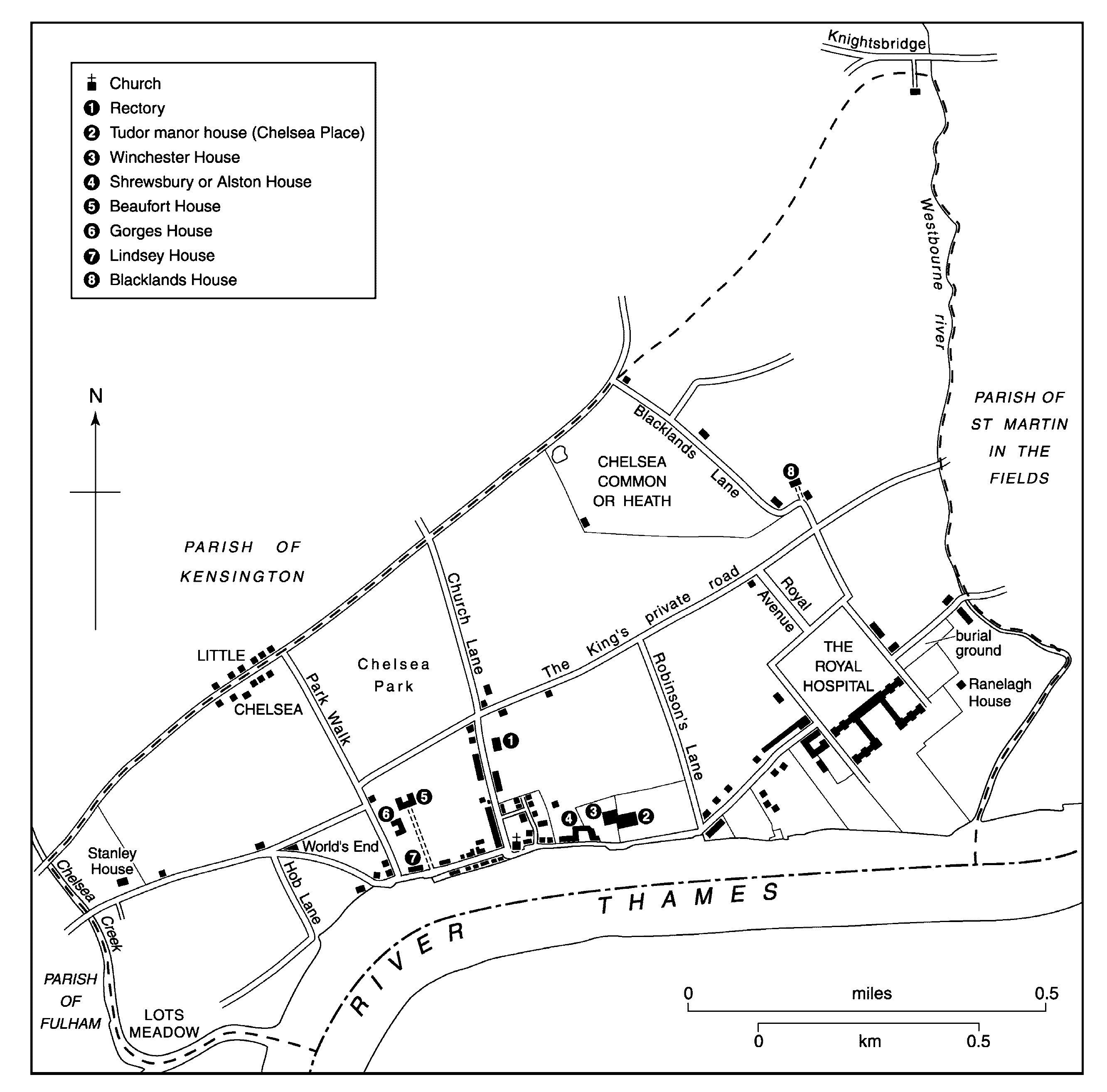
Chelsea c. 1700
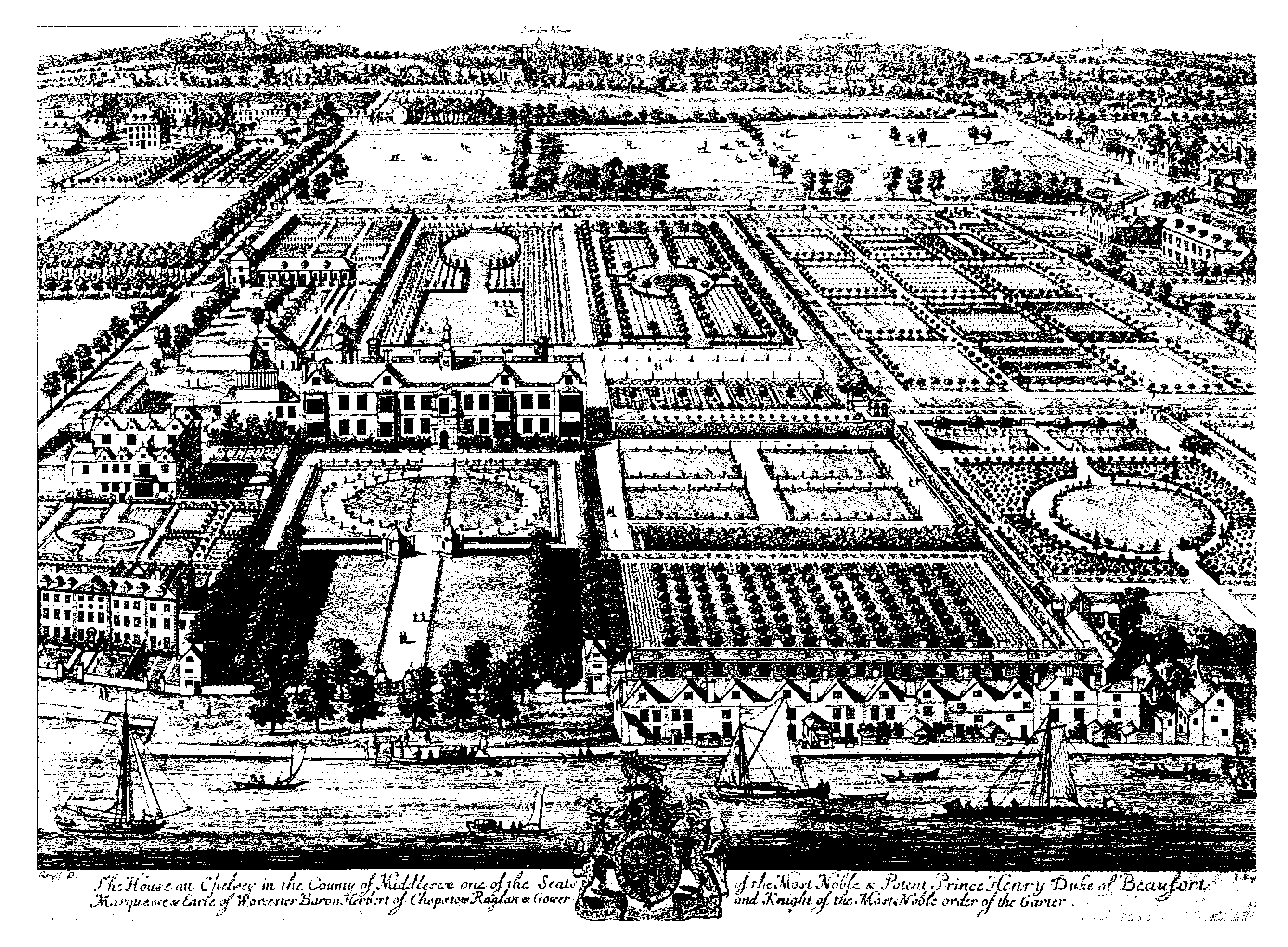
A depiction of Beaufort House and grounds c. 1708, with Lindsey House (extreme left), Gorges House (behind), gardens of former Danvers House (extreme right), and Little Chelsea showing the 4-storeyed Shaftesbury House (top left)
In 1724 Daniel Defoe's Tour was published in which he described 'Chelsea, a Town of Palaces', a remark apparently provoked by the Royal Hospital, and which, he presciently says, by its new extended buildings seemed 'to promise itself to be made one time or another a part of London'. He described the Royal Hospital and 'a little Palace' formerly the home of the earl of Ranelagh, describing the house and the charm of its situation and prospect. He then had to cease describing private houses and gardens as there were so many around London in the county of Middlesex. (fn. 8) He may not even have seen the Tudor manor house which later writers considered a palace because of its link with Henry VIII, or Winchester House, the palace of the bishops of Winchester, but his phrase has subsequently been echoed in almost every book written about Chelsea, though since Chelsea has become part of London, as Defoe thought it might, the 'town' has been changed to a 'village of palaces'. (fn. 9)
Like other villages separated from London by fields, Chelsea had problems with robberies on the highways leading through the parish, mentioned from the 16th century. In 1613 three yeomen had allegedly robbed a man in the highway at Chelsea; in 1692 one Parson Smith, reader or lecturer of Chelsea, stood accused of assisting highwaymen; John Verney found journeys from Little Chelsea to the City tedious in 1680, partly because 'rogues' made the road unsafe. (fn. 10) In the 18th century robberies by footpads and highwaymen were common. The Five Fields, just outside Chelsea's eastern boundary, were particularly notorious, although the situation improved by the early 19th century. The area around the Royal Hospital was also considered dangerous. (fn. 11) In 1761 the parishioners opposed the closure of the Hospital's grounds in the evening, necessitating a detour attended with dangers including frequent robberies. (fn. 12) In 1816 the vestry's application to have a road for carriages, rather than only allowing people to walk through Burton's Court after dark, (fn. 13) was unsuccessful. (fn. 14)
Though Chelsea had been one of the villages around London and Westminster which housed eminent residents in the 17th century, it developed a more particular role and gained more fame as an 18th-century riverside pleasure resort, where people could come for the day or take lodgings for the summer. The main focus of this was Ranelagh Gardens, opened in 1742 and for about 40 years the height of fashion for entertainments, but visits by boat to Chelsea to dine at a riverside tavern were a quiet but pleasant way to escape from the crowds, noise and smells of London. The main street in the village along the river was lined with inns, while some isolated taverns in the fields and along the highways, like World's End, provided more rural surroundings. (fn. 15) The new houses of Cheyne Walk included at least two taverns. (fn. 16) By the second half of the 18th century Chelsea was attracting greater artistic attention as well, its riverside, picturesque old buildings, and stately mansions and grounds by the river all being favoured subjects for paintings and engravings. (fn. 17)
In 1693 the Crown made a payment towards building a road between Kensington and Chelsea, (fn. 18) presumably for Royal Avenue from the Royal Hospital to King's Road, thought to be the only section actually built of a grand route planned by William III to run between the Royal Hospital and Kensington Palace. (fn. 19) In 1717 just four roads connected Fulham Road with King's Road and five routes ran south from King's Road to the river, (fn. 20) but from the 18th century building gradually opened up further north-south routes through the parish. In 1778 George III granted permission for Sloane Street and Lower Sloane Street to be opened up into the king's private road. (fn. 21) There were already many houses built along King's Road from the late 17th century, such as on freeholds south of Chelsea common, and on the glebe near the rectory, though many also had some kind of access from other directions. Local use must already have been heavy by the time the road passed into public ownership in 1830 and was open to all. This was a pivotal moment in Chelsea's history: Chelsea already had a new parish church north of King's Road and several public facilities around it; the convenient highway into and through the middle of the parish inevitably became the focus for commercial life and also for new building, and diminished the role of the old centre by the former parish church on the riverside.
The shift from an 18th-century village resort to a 19th-century metropolitan suburb sometimes moved faster than the vestry and parish officers could deal with. The vestry were reluctant to incur expense in connection with highways and footpaths: they refused to take on the recently-constructed Sloane Street in 1782, (fn. 22) and roads at Queen's Elm used for some years were only adopted as parish highways in 1799 after proprietors had constructed drainage and paved the footpaths. Riley Street was taken on following drainage work in 1800. (fn. 23) The parish feared the expense of taking on roads requiring work, for example in 1828-9 when a road across Chelsea Common which required drainage had been adopted. (fn. 24)
Paving also assumed importance when from 1774 the vestry submitted names for the appointment of two surveyors by magistrates. Piecemeal improvements included paving crossways at Swan Walk and Bull Walk near the river in 1781, like those in Manor (later Chelsea Manor) Street and Lawrence Street already done. In 1788 the vestry acted to keep Justice Walk open and in 1789 ordered that the enclosure of part of Millman Row be reversed. (fn. 25) In 1801 the parish was responsible for 3½ miles of road and three-quarters of a mile of footways; the turnpike roads totalled 3¼ miles. (fn. 26) In 1815-16 the vestry sought exclusion from a Bill for paving metropolitan streets, as the extent of Chelsea's foot-and carriageways would make paving expensive, and also resisted a local scheme for paving outside Hans Town. In 1816 the vestry made a paved crossing near the King's Road burial ground. (fn. 27) Following an Act of 1821 to improve collection of the highway composition, administrative improvements were attempted in 1822 and the streets were better regulated by 1829. (fn. 28) In 1823-4 drainage was improved and paving was in progress in the late 1820s, funded partly by private contributions. (fn. 29) In 1829 the vestry thought few districts had better roads and footpaths, although surveyors were urged to continue curbing footpaths. (fn. 30) In 1833 expenditure on paving was controversial, (fn. 31) and in 1834, despite opposition, a highways board was appointed to avoid partiality and the continual reversal of work by succeeding surveyors. (fn. 32) The old system was revived in 1836-7, only to return to the board system in 1838. (fn. 33)
In 1792 Chelsea inhabitants formed an association to aid the magistrates in preserving order, which directed the constables and watchmen to suppress inflammatory writings, and tried to prevent seditious assemblies. Patrolmen from Bow Street attended when a riot was feared; journeymen at a manufactory in Church Lane (later Old Church Street) were discouraged from burning an effigy of Tom Paine. (fn. 34) That year John Martin and others, indicted for seditious talk and assault and said to belong to the Free and Easy or Arthurian Society, a political club, were suspected of being behind a planned riot which was prevented by the Chelsea association. (fn. 35)
As a measure of its new urban status, the London Building Act of 1774 added Chelsea and three other parishes to the cities of London and Westminster and parishes in the bills of mortality, to regulating building there. (fn. 36) Chelsea also acquired some other urban features, such as hackney coaches which plied at the Royal Hospital in 1771. (fn. 37)
In 1825 three private Acts received royal assent allowing the Cadogan trustees to grant building leases on the Cadogan settled estates, and to demolish Winchester House and grant building leases of the site, and allowing the rector to grant building leases for 33 acres of glebe. (fn. 38) Despite new building steadily taking place, however, in the 1830s much of Chelsea was perceived as a rather down-at-heel locality. In 1834 Carlyle wrote of his affection for his 'excellent old house': Chelsea was unfashionable and had numbers of old houses, 'at once cheap and excellent'. (fn. 39) Another writer contrasted Chelsea's 'barbarism' with the 'aristocratic pavements' of neighbouring Belgravia in 1839. (fn. 40) In 1839 the highway board was ordered to water the roads in summer to keep the dust down; not only comfort but the value of property was thought to depend on the quality of the roads. Considered a success, summer watering was ordered to be extended in 1841, and was carried out again in 1843-4, despite doubts about the legality of using the highway rate for this. By 1843 the highway board had improved footpaths and made stone crossings on principal streets, but in 1844-5 paving was partly financed by private contributions. (fn. 41) A complaint of 1844 from a King's Road business about new pavements which narrowed the carriage road revealed tensions between tradesmen sympathetic to parishioners' interests and those more interested in wheeled traffic from farther afield. (fn. 42)
The prospect of an embankment along the Thames was a stimulus to the Chelsea Improvement Act (1845) for maintaining the parish's streets and footways (excepting Hans Town and Fulham Road). (fn. 43) Under the Act a board of 50 commissioners replaced the existing boards of highway surveyors and lighting inspectors and were given extra powers to make, pave, clean, water, and drain streets, collect waste, and deal with nuisances, and to levy rates for the purpose. (fn. 44) Its implementation was contentious. An improvement society argued that the commission would regenerate Chelsea by paving throughout, removing obstructions, and, above all, by creating new thoroughfares, particularly around the Royal Hospital and in southern Chelsea west of Church Street. A ratepayers' association, however, feared that rates would be squandered. (fn. 45) The commissioners, first elected in August 1845, began work energetically that autumn, meeting far more often than the monthly minimum. (fn. 46) By November it was reported that the results of the rate levied on local householders could be seen: tollgates had been removed, allowing buses to serve Little Chelsea, and many footways, especially in King's and Fulham roads, had been paved. (fn. 47) The commission maintained, cleansed, watered, and improved roads; paving was laid down, sometimes in response to complaints about particular streets; (fn. 48) a uniformed street-keeper was appointed whose duties included dealing with obstructions. (fn. 49)
Meanwhile sewage was causing concern as medieval ditches struggled to cope with the effluent from the many new houses discharging into the natural watercourses. In 1854 50 householders and residents in the neighbourhood of Sloane Square complained that the petition which they with local incumbents and surgeons had presented to the Metropolitan Commissioners of Sewers regarding the Westbourne or Ranelagh Sewer had been ignored. The sewer had been covered as far as Sloane Square, but thereafter was open down to the Thames, and by 1854 each side was lined with dwellings densely crowded by the poorest classes, who had suffered great sickness the previous year, presumably because of the filthy stream. The petitioners wanted it covered the whole way, since cholera and fever had again appeared. (fn. 50)
The parish also resisted a proposal in 1863 to build new barracks in Chelsea on Quailfield (later the site of Lennox Gardens) to replace Knightsbridge Barracks: residents and the rector of Upper Chelsea strongly opposed the barracks, as the parish would be deprived of a large number of ratepayers if barracks were built instead of houses, and the parish already had three great military establishments. (fn. 51)
The number of new houses built in Chelsea between 1831 and 1842 averaged nearly 91 a year, despite a slump in the mid 1830s. Well over half were 4th class, the mid point in the range. (fn. 52) As building increased more streets were taken over by the parish, for example William Street in 1837, (fn. 53) and others declared public by the improvement commission between 1846 and 1853, (fn. 54) although it still wished to ensure that the promoters, not the commission, paid for making up new roads. (fn. 55) In 1847 when it proposed a new road between Marlborough Road (later Draycott Avenue) and Hans Place to improve communications to Hans Town, a minority in the vestry felt that the road should be made by the proprietors. (fn. 56) In 1854 Chelsea improvement commission had over 19 miles of roads; Hans Town commission had four miles. (fn. 57) From 1864 the parish took over responsibility for the one mile of turnpike road still running through Chelsea, included in its 22 miles in 1872. The vestry continued to pave and improve streets, in 1856-72 flagging over 420,000 ft of footways. In 1872 all the roads were watered. (fn. 58) The vestry still considered that the embankment through Chelsea to Fulham was necessary, and calls for its extension continued. (fn. 59)