A History of the County of Stafford: Volume 14, Lichfield. Originally published by Victoria County History, London, 1990.
This free content was digitised by double rekeying. All rights reserved.
'Townships: Hammerwich', in A History of the County of Stafford: Volume 14, Lichfield, (London, 1990) pp. 258-273. British History Online https://www.british-history.ac.uk/vch/staffs/vol14/pp258-273 [accessed 25 April 2024]
In this section
HAMMERWICH
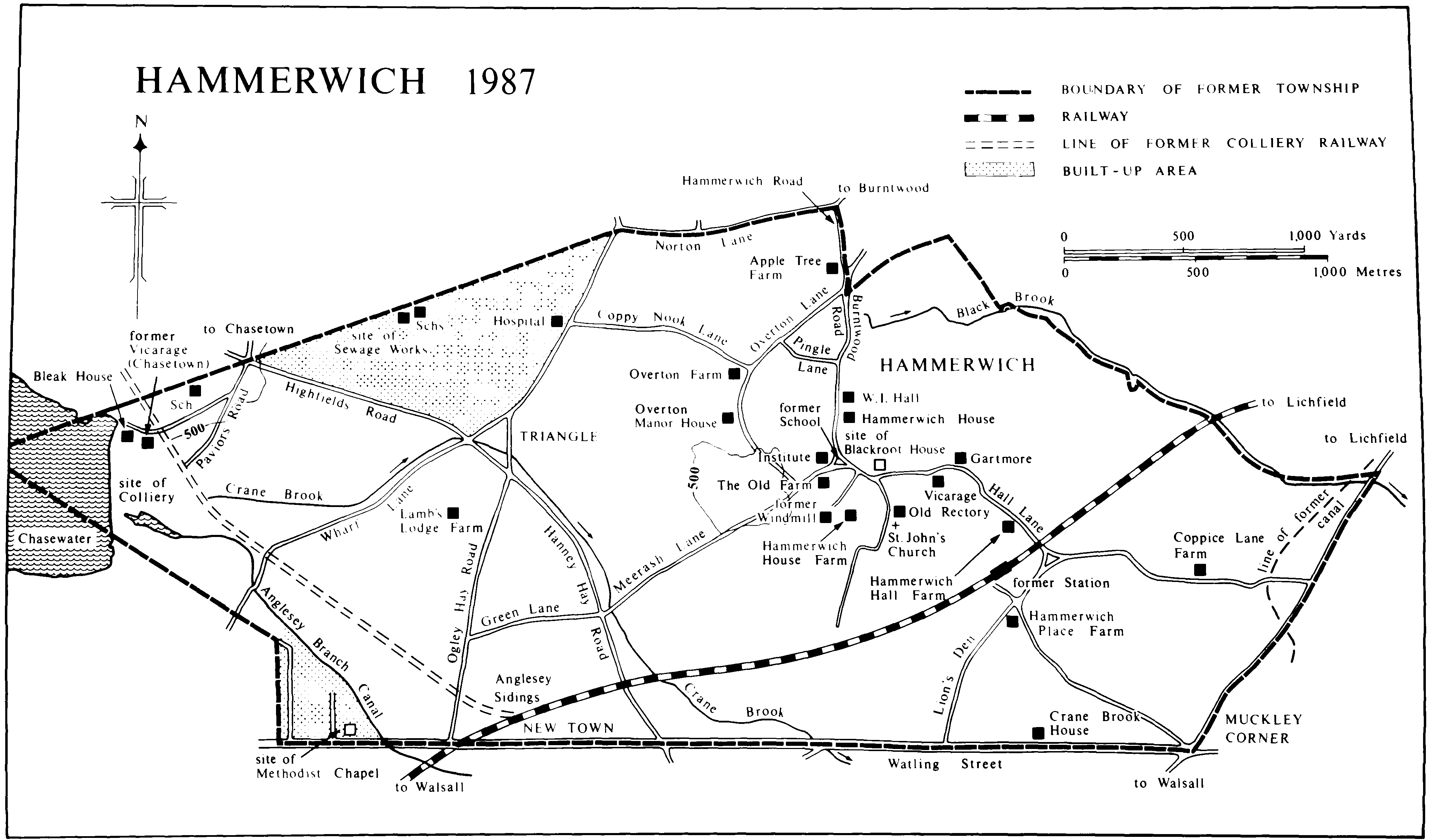
The civil parish of Hammerwich was formerly a township in the south-west corner of the parish of St. Michael, Lichfield. (fn. 1) It lay beside Watling Street, which formed the whole of its southern boundary. Formerly 1,779 a. (721 ha.), (fn. 2) its area was increased to 2,535 a. (1,027 ha.) in 1934 by the addition of the civil parish of Ogley Hay Rural south of Watling Street. (fn. 3) In 1966 the north-west corner of Hammerwich was transferred to the urban district of Aldridge-Brownhills, (fn. 4) and in 1980 there were further boundary adjustments with Burntwood, Wall, and Shenstone. (fn. 5) This article covers only the area of the former township. It is a district which remains largely rural. There was, however, a considerable increase in population following the opening of a coalmine in the north-west corner of the township in 1849, while in the later 20th century there has been extensive residential development.
The terrain is undulating and rises from 356 ft. (109 m.) on the eastern boundary to 503 ft. (153 m.) in the north-west. The church is a landmark, standing at 485 ft. (148 m.) on a hill top above Hammerwich village centre. North-west of the church the southern end of Overton Lane lies around the 500-ft. (152-metre) contour and is known as the Plateau. The Lower Keuper Sandstone underlies the eastern part of the parish and the Bunter Upper Mottled Sandstone and Pebble Beds the western part. The Eastern Boundary Fault of the Cannock Chase Coalfield runs across the north-west corner. There is Boulder Clay in the east and, with other gravelly drift, in the west. (fn. 6) Crane brook, mentioned in 1300, flows out of Chasewater, which was earlier known as Norton Pool, formed as a canal reservoir c. 1798. (fn. 7) Black brook, known as Hammerwich Water in the early 19th century, (fn. 8) rises at the north end of Hammerwich village and formed the north-eastern boundary with Burntwood until the change of 1980; it flows into Crane brook at Chesterfield, in the adjoining parish of Shenstone.
Thirty-one people in Hammerwich were assessed for the subsidy of 1327 and 28 for the poll tax of 1380–1. (fn. 9) Twenty-four were assessed for hearth tax in 1666. (fn. 10) The population of the township was 209 in 1801 and had risen to 270 by 1851. With the development of mining in the area it had reached 991 by 1861 and 1,325 by 1871. The increase then slowed, with many people leaving by the later 1870s because of the depression in the coal trade. The population of 1,391 in 1881 had risen to 1,573 by 1891. It had dropped to 1,546 by 1901. (fn. 11) Immigrants included a large number of Irish who settled in the west part of the parish. (fn. 12) Numbers had risen to 1,611 by 1911 and 1,772 by 1921, with a fall to 1,638 by 1931. The enlarged parish had a population of 2,285 by 1951 and 2,408 in 1961. Despite the transfer of a populous area in 1966 numbers were 3,538 in 1971 and 4,252 in 1981. (fn. 13)
Hammerwich lay within that portion of Cannock forest which became Cannock Chase in the 13th century. Until the later 19th century settlement was concentrated in the eastern part of the township, with the western part remaining heathland. The Old English name Hammerwich means a place (wic) by a hill (hamor). (fn. 14) There may have been two centres of population in the late 11th century, represented by the 'two Hammerwich' of Domesday Book. (fn. 15) Eventually there were three centres, Overton mentioned in the late 13th century, (fn. 16) Netherton in 1319, (fn. 17) and Middleton in 1381. (fn. 18) The names Nether town and Middle town were still used in 1871, (fn. 19) while Overton remains in use. There was still a green at each in the early 19th century. (fn. 20)
Netherton green lay around the junction of Hall Lane with Coppice Lane and with Lion's Den. (fn. 21) The continuation of Hall Lane south-east to Watling Street at Muckley Corner was known as Marebath Lane in the late Middle Ages and Marble Lane in the 19th century. (fn. 22) Lion's Den, so called by 1881, (fn. 23) was earlier known as Elder Lane, a name in use by the late Middle Ages. (fn. 24) Hammerwich Hall Farm on Hall Lane existed by the later 17th century and Hammerwich Place Farm in the angle of Hall Lane and Lion's Den by the 18th century. (fn. 25)
Middleton green was presumably the open space in the village centre now known as the village green. (fn. 26) Farmhouses were built or rebuilt in the central area in the 18th century, and a windmill was built in 1778. (fn. 27) In the later 19th century several large houses were built: Hammerwich House dates from c. 1870 when it replaced a farmhouse; (fn. 28) Fair View (later Blackroot House) was built in the mid 1870s and was then the home of T. B. Wright, the founder of Hospital Sunday; (fn. 29) Gartmore was built in the later 1890s by W. G. Leckie, a Walsall saddlery and harness manufacturer; (fn. 30) the vicarage house dates from 1894. (fn. 31) Hammerwich Square off the southern part of Overton Lane existed by 1871 when several miners were living there, (fn. 32) and other houses in that part of Overton Lane are dated 1904 and 1911. Council houses were built there between the two World Wars and c. 1960. (fn. 33) In the 1980s there has been considerable private residential development in the village centre, including an estate built over the grounds of the demolished Blackroot House. (fn. 34)
Overton green lay along Overton Lane between its junction with Pingle Lane and Coppy Nook Lane and was still the name used for that area in 1892. (fn. 35) Pingle Lane was mentioned in the earlier 15th century, (fn. 36) and Coppy Nook was an inhabited area by 1783. (fn. 37) Overton Manor House dates from the mid 18th century, but it has an earlier cellar. (fn. 38) The houses in Pingle Lane date from the late 19th century onwards and those in Burntwood Road from the early 20th century onwards. (fn. 39) A privately built estate in the triangle formed by Overton Lane, Burntwood Road, and Pingle Lane dates from the later 1980s.
Further north Norton Lane, which marks part of the boundary with Burntwood, was mentioned in 1449. (fn. 40) Sterre (or Star) Lane (later Hammerwich Road), running south from Norton Lane and continuing the boundary, was mentioned in 1453. (fn. 41) Apple Tree Farm in Hammerwich Road contains part of a small timber-framed building of the 17th century or earlier, which was incorporated in the rear wing of the house when it was enlarged in the 18th century. (fn. 42)
HAMMERWICH 1987
The south-east corner of the township at Muckley Corner was inhabited by 1775. (fn. 43) The farm to the west on Watling Street, later known as Crane Brook House, existed by 1843. (fn. 44) Coppice Lane Farm north of Muckley Corner dates from the mid 19th century. (fn. 45)
With the inclosure of the heathland in the western part of the township in 1856 under an Act of 1853 new roads were laid out and new settlements appeared. Already in the 18th century a warrener's lodge had been built on the heath. (fn. 46) By 1805 there was a cottage with a workshop near the northern end of the reservoir dam; (fn. 47) it may have been occupied in connexion with the reservoir. A coalmine was opened to the south in 1849; the cottage was enlarged as the manager's house, which became known as Bleak House, and two pairs of miners' cottages were built nearby. (fn. 48) Another house had been built east of Bleak House by 1856; it became the vicarage for St. Anne's, Chasetown, opened in 1865. (fn. 49) Building land on Watling Street was advertised for sale in 1854, and by 1861 new settlements of miners were developing in the south-west corner on Watling Street, at New Town to the east along Watling Street, and in the north-west at Pavier's Row and Triangle. (fn. 50) Pavier's Row (renamed Pavior's Road in 1962) had been built by 1860 and consisted of 21 cottages belonging to John Pavier of Hammerwich Place Farm. (fn. 51) In the early 20th century houses were built along Triangle Road, which was renamed Highfields Road. Building continued there in the years between the two World Wars, and council houses were built at Triangle in 1938. (fn. 52) The area on the north side of Watling Street in the west was rebuilt in the years following the Second World War.8 In the 1960s and earlier 1970s housing estates were built between Highfields Road, Hospital Road, and the Burntwood boundary, building which represents the extension into Hammerwich of the residential development of Burntwood.9
The Lichfield—Walsall road on the eastern boundary of the township was turnpiked as far south as Muckley Corner in 1729.10 The stretch of Watling Street forming the southern boundary of Hammerwich was turnpiked in 1789 to link the Lichfield—Walsall road at Muckley Corner and the Chester road just over the boundary with Norton Canes.11 In 1838 it was stated that a finger post had once stood where Watling Street crossed that boundary; a cross stood in the area in 1650. (fn. 53)
The Wyrley and Essington Canal, opened in 1797, ran through the east of Hammerwich. That stretch was closed in 1954, but for some years it had been used only by maintenance boats. (fn. 54) From Norton Pool reservoir a feeder ran through the township into Ogley Hay, linking the reservoir with the canal. (fn. 55) It was incorporated in the Anglesey Branch Canal cut in 1850 to link the new colliery with the main canal. (fn. 56) The branch became disused with the closure of the last of the Chasetown mines in 1959. (fn. 57)
The South Staffordshire Railway was opened through Hammerwich in 1849 with a station at Netherton. (fn. 58) There was an immediate rise in the value of property in Hammerwich. (fn. 59) The station, having become an unstaffed halt in 1959 or 1960, was closed for goods traffic in 1964 and for passengers in 1965, (fn. 60) and the buildings were converted into a private house. A railway linking the colliery with the South Staffordshire Railway at Anglesey Sidings at New Town was built in 1852. (fn. 61) The rails had been taken up by 1964.21
The Elias Ashmole Ashmall Institute was built in the centre of the village in 1911 in memory of a local farmer who was churchwarden for 34 years and died in 1889. Much of the cost was met by his son-in-law, Sir Richard Cooper, Bt., and the site was given by F. Villiers Forster and Sir Charles Forster. The building was extended in 1972.22 A women's institute was established in 1920. At first it met at the Ashmall Institute, but in 1936 a W.I. hall was built in Burntwood Road. In 1958 it became the church hall as well. (fn. 62) A community centre was opened in 1983 in the former village school. (fn. 63) A cricket match was played in 1871 between a Hammerwich club and Lichfield (St. Mary's) club, and in 1883 there was a match between Hammerwich and Burntwood, evidently under the auspices of the respective incumbents. (fn. 64) A cricket club was formed in 1948 and acquired a ground in Burntwood Road in 1978. (fn. 65)
ESTATES.
In 1086 the bishop of Chester held two estates in Hammerwich ('due Hameruuich') as part of his manor of Lichfield (later Longdon). (fn. 66) They were not subinfeudated as manors but were held of the bishop by freeholders, who paid a fine for a forest offence in 1166–7. (fn. 67) Assessed at 2 hides c. 1255, Hammerwich remained part of Longdon manor. (fn. 68)
A portion of the area, however, became part of Farewell manor. Bishop Clinton's endowment of the nuns of Farewell priory c. 1140 included ½ hide held by 'Haminch' (probably Hamon) of Hammerwich; half the estate was to be held by the nuns in demesne and half by Haminch's heirs as tenants of the nuns. Henry II, probably in 1155, confirmed the nuns in their possession of a carucate at Hammerwich with villeins, a free man named Hamon the fiddler, the lands of those tenants, and pasture which had belonged to the estate in 1135. (fn. 69) The nuns' estate in Hammerwich remained part of Farewell manor, which was granted to the dean and chapter on the priory's suppression in 1527 and to Lord Paget in 1550. (fn. 70)
The Stanleys, lords of Pipe in Burntwood, held property in Hammerwich of Longdon manor in the 15th century. (fn. 71) A house and lands in Hammerwich descended with Pipe in the 16th century, being held of Farewell manor in 1574 by Christopher Heveningham. (fn. 72) George Stanley, a younger son of Thomas Stanley, lord of Pipe, held an estate in Hammerwich of the bishop by 1475 and was described as lord of Hammerwich in the 1480s. (fn. 73) He died in 1509, and his son and heir John held three messuages and meadow in Hammerwich at his death in 1534. His home was then at West Bromwich, where the manor was held by his wife. John's son and heir Francis, lord of West Bromwich from 1552, was succeeded by a son George in 1558. (fn. 74) In 1574 George Stanley held a house and land in Hammerwich as part of Farewell manor. (fn. 75)
HAMMERWICH HALL
HAMMERWICH HALL, so called by 1741, (fn. 76) was the home of William Heath, the son of William Heath of Weeford, by the mid 17th century. He was living in Hammerwich in 1645, and in 1666 he was assessed for tax on eight hearths in the township, the largest assessment there. He died in 1676. (fn. 77) The hall and its estate were later the property of Charles Kendall, who was living in Hammerwich by 1727. (fn. 78) He was dead by 1734, and his three sisters were his heirs. That year one of them, Theophila, the widow of Job Reading of Woodhouses in Burntwood, sold her third share to Cornelius Reading of Pipehill, evidently her stepson. (fn. 79) By his will proved in 1774 Cornelius left most of his property to his son John, whose heir under his will of 1791 was his niece Ann, wife of the Revd. Francis Willington. (fn. 80) She was living at Pipehill by 1818. In 1821 Hammerwich Hall was occupied by John Pavier; by 1834 the tenant was his nephew Thomas Pavier. (fn. 81) Ann died in 1841 and left Hammerwich Hall to Thomas and his brother John of Hammerwich Place Farm. (fn. 82)
By 1843 Thomas was the sole owner of the Hall and its 144-a. farm, although he was no longer living in Hammerwich. (fn. 83) In 1860 he settled the reversion of the farm after his death on his daughter Mary. (fn. 84) In 1871 he inherited the Wall Hall estate from John; to secure the inheritance he changed his name to Jackson in accordance with the will of his uncle Edward Jackson. (fn. 85) Thomas died at Edial, in Burntwood, in 1885. (fn. 86) On Mary's death in 1898 Hammerwich Hall farm was divided between the two children of her first and second marriages, J. E. P. Norris and Caroline Brown. They sold it in 1924 to G. H. Holt of Apeton, in Church Eaton. He promptly mortgaged it to R. A. Watkins of Tamworth and George Horne of Stafford. In 1937 they sold it to James Lymer and Reginald Horne, both of Stafford, who sold it in 1947 to Thomas Williams, a coal merchant of Walsall; his father Simeon was already the tenant. Thomas moved there in 1960 and died in 1978. Hammerwich Hall farm passed to his widow Winifred, and after her death in 1987 it was divided among her grandchildren.
In the early 19th century the timber-framed house had a large block built at its west end. The timber-framed range was demolished to make way for a new house, built in 1960. (fn. 87) To the north is a brick barn with a date stone of 1786, and on the opposite side of Hall Lane is a three-bayed timber-framed barn of the 17th century with a later brick extension.
An estate centring on HAMMERWICH HOUSE originated in the estate in Hammerwich built up by Simon Biddulph of Lichfield from 1565. By 1574 it included four messuages held of Farewell manor. (fn. 88) Simon was succeeded in 1580 by his son Simon, who was followed in 1632 by his son, Michael Biddulph of Elmhurst. (fn. 89) In 1636 Michael granted a lease of a house and land at Hammerwich. The house was in decay, and the lessees were to build a new house of two bays, with three bays of other buildings, using the timber from the existing house. In 1655 Michael and his son Michael conveyed the reversion of the Hammerwich estate, including three messuages, after the elder Michael's death to a younger son Theophilus. (fn. 90) That death took place in 1658. Theophilus, created a baronet in 1664, was succeeded in 1683 by his son Michael. Sir Michael died in 1718, leaving a farm in Hammerwich and Edial to his wife Elizabeth. (fn. 91)
Elizabeth sold the farm to the tenant, Samuel Moor, in 1719, although the conveyance was not completed until 1725. By his will dated 1723 Samuel left the farm to his son Samuel, whose widow Elizabeth held it in 1749. That year, on the marriage of her daughter Elizabeth to Henry Webb of Hammerwich, she settled the reversion on the younger Elizabeth. Between 1781 and 1787 Henry rebuilt the house, and in 1799 he sold it to his son-in-law Thomas Middleton of Hammerwich. (fn. 92) By 1749 Henry had inherited from his uncle Henry Webb, a Tamworth innkeeper, another house in Hammerwich, which became his home. He subsequently sold it to Stephen Riley, whose son John Riley of Rugeley (d. 1803) left it in trust to be sold. It too was bought by Thomas Middleton in 1805. (fn. 93) In 1824 Middleton conveyed several houses in Hammerwich to his son William. (fn. 94) All that property was let, and he and his son were probably living in a farmhouse on the site of the later Hammerwich House. Thomas died in 1839, and in 1843 William owned and occupied the 38-a. farm. (fn. 95) In 1861 he was living in retirement at the farm, which was run by his son William. (fn. 96) The elder William died in 1862. (fn. 97) His son was living at Torquay (Devon) by 1865 when he settled his Hammerwich estate in trust to be sold. (fn. 98)
By 1868 the house, then known as Hammerwich House, was the home of Arthur Hills, a manufacturing chemist with a works nearby in Ogley Hay. He was still living there in 1876, (fn. 99) and it was probably in his time that the house was rebuilt. It was offered for sale in 1877 and 1878. (fn. 100) By 1880 it was the home of Job Evans, a manufacturer of galvanized iron apparently from Wolverhampton, who put it up for sale with 43 a. in 1895 on leaving the district. (fn. 101) It was the home of John Leckie in the later 1890s. (fn. 102) In 1901 it was bought by Benjamin Stretton (d. by 1912), whose widow Frances continued to live at Hammerwich House. (fn. 103) From 1941 it was used as an annexe by the Birmingham and Midland Hospital for Women at Sparkhill, Birmingham. Mrs. Stretton died in 1944, (fn. 104) and in 1945 Hammerwich House was bought by Walsall borough council. It was converted into a girls' remand home, opened in 1946. (fn. 105) It later became a children's home. In 1984 the council sold the house, which was reopened in 1985 as a private home for the elderly. In 1988 a nursing unit was added, the house having by then been renamed Hammerwich Hall. (fn. 106)
The estate known by the 1860s as HAMMERWICH HOUSE FARM was held in the 18th century by the Dolphin family of Shenstone. John Dolphin probably inherited it from his father John (d. 1724). In 1756 the younger John was succeeded by his nephew John Dolphin, who was himself succeeded in 1782 by his son Thomas Vernon Dolphin. In 1802 Thomas sold a house and 90 a. in Hammerwich to William Stubbs, a farmer of Little Wyrley in Norton Canes, who moved to Hammerwich. By 1833 he had left Hammerwich and the farm was occupied by his son William, who was probably working it by 1828. William succeeded his father in 1837. (fn. 107) By 1864 he was living in Mill Cottage. He died in 1865, leaving what was by then called Hammerwich House farm to his son Thomas, who had farmed there earlier but had left to farm at Teddesley Hay. (fn. 108) In 1857 William had exchanged part of his land with the marquess of Anglesey for Lamb's Lodge and 6 a. adjoining, and by 1863 he had a 49-a. farm centring on the lodge; in his will he left that farm to be sold to pay Thomas's debts. (fn. 109) From the early 1900s Hammerwich House farm was held by J. E. Fawcett and from c. 1910 by T. W. Fawcett. (fn. 110) It was offered for sale in 1919. (fn. 111) By 1924 it was farmed by Edward Fawcett, who sold it in 1959 to Mr. T. J. Bailye, the owner in 1987. (fn. 112) The brick farmhouse was described in 1833 as newly built. (fn. 113)
The farm known as HAMMERWICH PLACE FARM by the 1890s (fn. 114) was acquired in the 18th century by the Pavier family. (fn. 115) A John Pavier was living at Hammerwich in 1743, (fn. 116) and in 1772 a John Pavier was farming 198 a. there. (fn. 117) The farm was occupied by another John Pavier in 1834. (fn. 118) He lived there until his death in 1871, having changed his name to Jackson in 1860 in order to inherit the Wall Hall estate. (fn. 119) By 1920 the farm, 126 a. in extent, was the property of H. A. Russell-Pavier. That year he sold it to Harry Cox, who farmed there until the later 1930s. In 1939 it was sold to Fred Barratt, and the Barratt family owned and occupied the 160-a. farm in 1987. (fn. 120) The house dates from the 18th century, but the garden front of three bays with a central doorway was added in the earlier 19th century. The garden has a terrace with statuary at either end. The pond on the opposite side of Hall Lane and the adjoining parkland, decayed by 1987, formed much of the 17-a. estate in John Pavier's occupation in 1843 (fn. 121) and remained part of the farm.
The farm known as the OLD FARM by the 1890s (fn. 122) was formerly the endowment of the charity established under the will of Eleanor Alport dated 1727 to benefit eight Staffordshire incumbents. The farm had 72 a. in 1843 and 110 a. in 1921 when the trustees of the charity sold most of it to T. J. Moss. On Moss's death in 1956 it passed to his daughter Mrs. I. M. Bailye, and she and her family occupied the farm in 1987. (fn. 123) The house has a brick front range of three rooms, with the date 1767, (fn. 124) and a two-roomed back range, probably contemporary.
OVERTON GRANGE
OVERTON GRANGE was held of Longdon manor in the mid 16th century by William Orme. (fn. 125) He probably succeeded Thomas Orme, who was frankpledge for Hammerwich from 1503 until 1528 and may have died c. 1539. (fn. 126) William was one of the Hammerwich chapelwardens in 1553. (fn. 127) By 1563 he had been succeeded in the property by Fabian Orme, who was living at the Grange in 1571. (fn. 128) He was alive in 1590, but by 1597 the Grange was held by his widow. (fn. 129) It passed to George Orme, who was living in Hammerwich in 1603 and 1628. (fn. 130) A Mrs. Orme was assessed for tax on three hearths in Hammerwich in 1666. (fn. 131) In 1574 another house in Hammerwich also called the Grange and lands attached were held of Farewell manor by Thomas Smith. (fn. 132)
There were two farms at Overton in 1843. One, known as Overton farm by 1896, (fn. 133) had 74 a. and was owned by the Revd. Josiah Webb Flavel. (fn. 134) After his death in 1848 the house and 100 a. in Hammerwich and Edial were divided between his sons, the Revd. John Webb Flavel and Thomas William Flavel. Thomas bought his brother's share in 1859, although no conveyance was executed until 1871. In 1884 Thomas's mortgagees put the farm up for sale. (fn. 135) By the later 1880s it was occupied by Joseph Pyatt. (fn. 136) He was followed c. 1905 by Ernest Pyatt and he c. 1910 by Sidney Pyatt. (fn. 137) Sidney had left by 1940 and sold the farm in 1943 to E. J. Bailey, from whom the house was bought in 1984 by Mr. and Mrs. M. J. Darwin, the farm being divided up. (fn. 138) The house dates from c. 1900.
The other farm in 1843, 135 a. in extent, was owned by Charles Smith Forster and John Forster, who were evidently the owners by 1837. (fn. 139) The Forster family still owned land in Hammerwich in 1911. (fn. 140) By the late 1930s the farm was known as Overton Manor farm and was occupied by A. T. Price, who sold it in the 1950s to E. J. Bailey. (fn. 141) The house, in 1987 called Overton Manor House, later passed to the Bosworth family, from whom it was bought in 1973 by Mr. and Mrs. L. V. Ray. (fn. 142) It is a symmetrical brick house of the mid 18th century with an older stone cellar. (fn. 143)
By the later 16th century the tithes of Hammerwich were held by the prebendary of Freeford in Lichfield cathedral. (fn. 144) The small tithes passed from the prebend to the vicar of St. Mary's, Lichfield, as part of the augmentation of that living by Bishop Lloyd in 1694. (fn. 145) By the beginning of the 19th century tithes of hay from 'ancient meadow' had been commuted for a customary payment of 1d. a year for each acre. (fn. 146) In 1843 the small tithes were commuted for a rent charge of £62 payable to the vicar of St. Mary's and the great tithes for one of £197 payable to the Ecclesiastical Commissioners, to whom the revenues of the prebendary of Freeford had passed under the Cathedrals Act of 1840. (fn. 147) In 1860 the Commissioners assigned their rent charge to the incumbent of the new parish of Hammerwich. (fn. 148)
The Church Lands charity originated in property belonging to Hammerwich chapel in the Middle Ages. Land in Hammerwich known in 1295 as 'Chapeleynesmor' (fn. 149) was probably part of it. Robert Sterre, who held a house and two selions in Hammerwich of Farewell priory in 1319 and was still living in 1327, was probably the man of that name who left the chapel a rent of 2d. from the selions; by 1377 the rent had been taken into the hands of the prioress. (fn. 150) By the early 16th century the chapelwardens held 2 a. of waste in Hammerwich formerly held by Maud Sterre (d. probably c. 1400), and they paid a rent of 12d. for it to the bishop as lord of Longdon. (fn. 151) In 1549 the chapel's endowments were listed as a priest's house, a chapelyard, Sterre croft in Hammerwich, and a meadow in Shenstone. (fn. 152) The Crown sold the chapel, the chapelyard, and lands in Hammerwich, all described as concealed lands, to two speculators in 1564. (fn. 153) In 1571 the chapelwardens held Sterre croft of Longdon manor for a 12d. rent; it was described as having been 'concealed land and so bought of the prince', presumably by one of the Pagets, the bishop's successors at Longdon. (fn. 154) Another estate in Hammerwich consisting of a cottage and ½ a. with 1 a. in Chapel field was held of Lord Paget's manor of Farewell by the inhabitants of Hammerwich in 1574; (fn. 155) it had been amalgamated with the chapel's endowments by 1716.
In that year Sir Michael Biddulph and others conveyed the chapel, the chapelyard, and lands to trustees. The lands consisted of a croft lately in the possession of the wardens, a meadow in Shenstone, a cottage, what was by then called Star croft, and a meadow, all in Hammerwich, and an acre at the bottom of Chapel Lane, formerly part of Chapel field. The profits were to be used to relieve the inhabitants 'from the payment of taxes and fifteenths thereafter to be due out of the said town' and to repair the church. (fn. 156) By the 1790s the income from what were then called the Church Lands was £5 10s. (fn. 157) In 1820 the property, 11 a. in extent, consisted of three houses and land in Norton Lane, including the 7-a. Star croft, another house and other land in Hammerwich, and a 1½-a. field and a piece of land in Shenstone. (fn. 158) The rent from Star croft in 1821 was £10 and from the rest £4 4s. The £10 was used for repairs, but when not so required it was banked; the balance in 1821 was £104 16s. The other rents had come to be enjoyed by successive ministers, who apparently regarded the land as glebe; the incumbent still seems to have been receiving them in the 1850s. (fn. 159) John Jackson (formerly Pavier) of Hammerwich Place Farm, by will proved 1871, left the trustees £100, the interest to be used for church purposes. (fn. 160) There were 10 trustees at the beginning of the 19th century but only eight in 1834. (fn. 161) The Church Lands charity remains in the hands of eight trustees, four of them elected by the ratepayers and four co-opted. Half the income is spent on the fabric of the church and half is applied to the general benefit of the inhabitants of Hammerwich. The church received £1,700 in 1987. (fn. 162)
The vicars choral of Lichfield cathedral held property in Hammerwich of Longdon manor in 1463. (fn. 163) In 1574 they held a house and a cottage there, closes covering 12 a., and 24½ a. in the open fields; that estate was held of Farewell manor. (fn. 164) In 1662 Elias Ashmole became the vicars' tenant in Hammerwich; he renewed the lease in 1673 and was considering a further renewal at the time of his death in 1692. (fn. 165) He in turn granted sub-leases in 1669 and 1677. (fn. 166) In 1858 the vicars owned 72 a. in Hammerwich, including Coppice Lane farm. (fn. 167) They conveyed all their property outside the Close to the Ecclesiastical Commissioners in 1872. (fn. 168)
The college of the cathedral chantry chaplains held an estate in Hammerwich by 1469. At the time of the suppression of the college in 1548 its property in Hammerwich consisted of a house and land, which were sold by the Crown to speculators in 1564. (fn. 169) It may have been the estate in Hammerwich which the Crown granted to the Savoy hospital in Westminster in 1556; the grant was surrendered in 1558. (fn. 170)
Oseney abbey (Oxon.) held a pasture in Hammerwich by the 16th century, probably as part of its Shenstone estate. (fn. 171)
The 'Himersiche' held by the nuns of Blithbury priory in Mavesyn Ridware, probably in the later 12th century, has been identified as Hammerwich. (fn. 172) The identification seems improbable.
ECONOMIC HISTORY.
Agriculture.
In 1086 the two Hammerwich estates consisted of five carucates and were described as waste. (fn. 173) By the late 14th century there were at least three open fields. Chapel field extended south and south-east of the church; selions in it were bounded by Crane brook, Watling Street, and Lion's Den. (fn. 174) It was mentioned in 1381 and still existed in 1634, but it was inclosed, probably in its entirety, by 1716. (fn. 175) It was adjoined by Lightwood field, where selions were bounded by Lion's Den, Watling Street, and Hall Lane c. 1500. (fn. 176) Chapel field was also adjoined by Little field, which contained selions bounded by Lion's Den c. 1500 and was still an open field in the earlier 17th century. (fn. 177) An open field called Windmill field existed by 1381 and, as Willman field, still existed in 1655. (fn. 178) Overton field, mentioned in 1440, was still an open field in 1598. (fn. 179) In 1406 John Overton was presented for holding Watte croft in severalty, although it was customary for it to be common every third year; John Webb was presented for the same offence in 1461. (fn. 180) Oatcroft field or Oat field was open in 1571 and 1598, but it had evidently been inclosed by 1628 when there was mention of a close or pasture called Oatcroft or Great Oatcroft. (fn. 181)
Several plots of 'new land' inclosed from the waste in Hammerwich were held of the bishop in 1298. (fn. 182) Land called Cambrell in the portion of Hammerwich within Farewell manor was described in 1589 as recently ploughed from the waste, and the inhabitants were then ordered to repair the hedges and fences round it. (fn. 183) In 1599 a similar order was made regarding land lying in the portion within Longdon manor and described as lately inclosed from Cannock heath. (fn. 184) Cambrell was evidently part of the land on the heath which by the early 18th century it was customary to inclose and 'lot out' among the inhabitants of Hammerwich; after being cultivated for four or five years the land was thrown open again. The practice came to an end when it became part of a warren c. 1717. (fn. 185) In 1789 the earl of Uxbridge as lord of Longdon granted 11 inhabitants of Hammerwich a 21-year lease of the upper part of a common called Muckley field in the south-east corner of the township at a rent of 2s. an acre. They were permitted to inclose the land and divide it among themselves in proportion to their existing holdings; at the end of the 21 years it was to be thrown open again. (fn. 186) During the earlier 19th century, however, it was still cultivated as a number of separate holdings. (fn. 187) In 1856 the 670 a. of remaining waste in Hammerwich were inclosed under an Act of 1853. They lay mostly in the west of the township but included Upper and Lower Muckley fields. (fn. 188) The inhabitants of Hammerwich also enjoyed common rights in Ogley Hay, an extraparochial heath south of Watling Street. It was inclosed in 1839 under an Act of 1838. (fn. 189)
In 1298 two of the bishop's eight free tenants in Hammerwich owed labour services and pannage as well as rent and suit of court. Henry Wymer, who held 2 virgates, had to send two men to mow the meadow at Williford in Whittington for one day or else pay 8d., and he owed two pigs or 2s. for pannage. Agnes of Overton, who held 1 virgate, had to send one man to mow the lord's meadow for one day or pay 4d., and she owed one pig or 12d. (fn. 190) The same services were due from the two holdings in the early 16th century, with carrying services worth 8½d. as well in the case of the second. (fn. 191)
In the 14th century six of the c. 30 free tenants on Farewell priory's estate in Hammerwich owed labour services at harvest time. (fn. 192) Mowing service, however, had been commuted for payments of between ½d. and 2d. by the early 14th century, and by then six tenants paid between 1¼d. and 3d. for pannage. By 1399 one of the pannage payments had been increased to 2s. but the other five were unchanged. Demesne farming on the priory's Hammerwich estate seems to have ceased by 1419.
Peas and oats were grown at Hammerwich in 1359–60, (fn. 193) and rye, peas, and oats were sown there in the later 1370s. (fn. 194) Wheat, rye, and barley were grown in the later 17th century, with smaller quantities of hemp and flax. (fn. 195) By the late 1860s the main crops were wheat, turnips, and barley. (fn. 196) Wheat and oats were advertised for sale at Lamb's Lodge farm in 1894. (fn. 197) When Hammerwich Place farm was put up for sale in 1920, it was described as very suitable for growing corn and potatoes. (fn. 198) The chief crops in 1984 were barley (140.7 ha. officially recorded), wheat (70.1 ha.), and potatoes (40.6 ha.). (fn. 199)
There were two shepherds among Farewell priory's free tenants in Hammerwich in 1318, (fn. 200) and sheep farming continued there, with the extensive heathland providing grazing. In the later 17th century most farms combined it with cattle farming. (fn. 201) There were four shepherds living in the township in 1861, though only one in 1871. (fn. 202) In 1984 the livestock officially recorded consisted of 442 cattle and calves, 1 pig, 1,338 sheep and lambs, and 1,340 poultry birds, mainly hens and pullets. (fn. 203)
In 1772 the inhabitants of Hammerwich were suffering extensive damage from moles. That year 15 people entered into a 31-year agreement with Samuel Insley, a Weeford mole catcher, who undertook to destroy the moles and to keep the township free of them. He was to be paid 1d. an acre a year. (fn. 204)
Park and warren.
Farewell priory had a park at Hammerwich in the late 1370s. (fn. 205)
About 1717 John Lamb, a Lichfield coachmaker, laid out a warren on the Hammerwich part of Cannock Chase, stocking it with rabbits from another warren on the Chase. He built a lodge but later pulled it down and built another on a spur of high ground south of the later Triangle. The inhabitants of Hammerwich, faced with loss of pasture and destruction of their corn, resisted for some five years by digging the rabbits out and killing them. Lamb and his tenant at the lodge overcame their opposition by giving them fair words and the occasional rabbit. (fn. 206) By the mid 18th century the warren, held by John Hodgkins, covered several hundred acres. It consisted of 411 burrows, of which 311 had three pairs of rabbits each and 100 eight pairs each. (fn. 207) It was one of those destroyed in the attack on the Cannock Chase warrens by inhabitants of the area in the winter of 1753–4. It was restocked and still existed in 1824, when it extended into Burntwood. (fn. 208) By 1863, after the inclosure of 1856, the lodge had become the farmhouse of the 49–a. Lamb's Lodge farm. (fn. 209)
Windmills.
In 1300 Henry Wymer held a windmill in Hammerwich. It was probably part of the estate in Hammerwich and elsewhere which had been granted to him by Henry Wymer the elder in 1280 and then included four mills. (fn. 210) It is the earliest windmill in Staffordshire of which there is definite record. (fn. 211) In 1574 a windmill on Brankeley flat in Chapel field formed part of the Hammerwich estate belonging to Farewell manor. (fn. 212)
A windmill was built west of the church in 1779 by Thomas Middleton, described as a maltster in 1799 and 1811. (fn. 213) He was still working it in 1823, but it was let by 1824 when he conveyed it with the rest of his property in Hammerwich to his son William. (fn. 214) By then it was known as Speedwell mill. (fn. 215) It was advertised for sale in 1827 with a newly built three-bedroom house adjoining it. (fn. 216) It was worked in the earlier 1830s by Thomas Davis. (fn. 217) By 1841 it was owned by Elizabeth Benton and worked by John Benton, probably her son. He continued as the miller until his death in 1881, (fn. 218) and his widow Elizabeth worked the mill until her own death in 1898. (fn. 219) It then ceased grinding and was dismantled in 1908. It was bought by Robert Sanders, the Hammerwich postmaster, who converted it into a house and added a battlemented top to the tower. The house was modernized in 1976–7 and a fibre-glass cupola placed on the tower. (fn. 220)
Industries.
A 'bendwareman', evidently involved with hardware, was living in Hammerwich in 1604. (fn. 221) A Hammerwich nailer was mentioned in 1774, (fn. 222) and there was a nailer's shop in the later Station Road at Netherton in 1824. (fn. 223) There were many nailers in the township in 1841 and 1851, but only two in 1861. (fn. 224)
Coal may have been mined in the earlier 17th century. Michael Biddulph's lease of his Hammerwich estate in 1636 included the provision that the lessees were to take a cartload of pit coals to his house at Elmhurst every year at his expense. (fn. 225) The 19th-century exploitation of coal in the area began in the north-west corner of Hammerwich. A mine was opened there east of the dam of Norton Pool in 1849, and in 1850 the Anglesey Branch Canal was cut through the south-west part of the township to connect the mine with the Wyrley and Essington Canal in Ogley Hay. A railway was completed through the same area in 1853, running from the South Staffordshire Railway at New Town to the expanding mining area. The Hammerwich mine was closed in 1856, but the canal and railway continued in use. (fn. 226)
There were stonepits north-east of the windmill in the early 1840s, and the stone for St. James's church at Ogley Hay, built in 1850–1, was quarried there. The quarry also supplied the stone for the rebuilding of Hammerwich church in the earlier 1870s. (fn. 227) In the earlier 1840s there was a gravel pit straddling the boundary with Burntwood at the north end of the pool dam. Gravel was still being worked on the Hammerwich side in the early 1880s. (fn. 228) By then, and probably by the early 1870s, there was a gravel pit on the south side of the canal near Watling Street. (fn. 229) By 1915 there was also a sandpit there and another to the north by the railway. (fn. 230) Working had spread north to a site off Wharf Lane by 1957, (fn. 231) part of which was still worked in 1987. There was a sandpit east of Hammerwich House in the early 1880s. (fn. 232) A brickyard was opened near the west end of Highfields Road shortly after the inclosure of 1856. (fn. 233) In the early 1880s there was a brickyard south of Norton Lane. (fn. 234)
LOCAL GOVERNMENT.
In 1293 Hammerwich attended the view of frankpledge for Longdon manor, held at Lichfield. (fn. 235) It formed a tithing and by 1327 was represented by a single frankpledge. (fn. 236) A headborough was still appointed at the Longdon court in 1728. (fn. 237) The part of Hammerwich within Farewell manor was presenting at the Farewell view by 1290. The tithing was represented by two frankpledges, and that was still the number in 1636. (fn. 238) There was only one in 1703, and one was still appointed in 1722. (fn. 239) Hammerwich was a constablewick by the 14th century, and a constable was still appointed at the Longdon court in 1839. (fn. 240)
In 1473 the Longdon court ordered the Hammerwich constable to repair the pound. (fn. 241) The Farewell court appointed a pinner for Hammerwich in 1715 and 1722, and one was appointed at the Longdon court in 1839. (fn. 242) A pound on the village green was moved to the south-west corner of the green in the mid 19th century to make way for the new school. (fn. 243) It was still being maintained in 1896 by the parish council, which that year also appointed a pinner. (fn. 244) It was evidently disused by 1900, and in 1907 it was dismantled and the site sold. (fn. 245)
Formerly a township in the parish of St. Michael, Lichfield, Hammerwich was recognized as a civil parish by 1871. (fn. 246) It was included in Lichfield poor law union, formed in 1836. (fn. 247) Having been part of Lichfield rural district, it became part of the new Lichfield district in 1974.
Hammerwich had two chapelwardens by the early 16th century. (fn. 248) There were two overseers of the poor by 1832. (fn. 249) The parish council appointed a salaried highway surveyor in 1896. (fn. 250)
The inclosure award of 1856 assigned 2 a. in Hanney Hay Road to the churchwardens and overseers of the poor for the benefit of the labouring poor, subject to a rent charge of £1 payable to the incumbent. (fn. 251) It was divided into plots which were let out, but from 1936 it was let as a single plot. (fn. 252) In 1979 the council repossessed the land and in 1980 decided to incorporate it in the adjoining Jubilee Park. (fn. 253) The park itself had originated as a 2-a. allotment under the inclosure award for the recreation of the inhabitants of Hammerwich and the neighbourhood. (fn. 254)
PUBLIC SERVICES.
A sewage works for Chasetown was opened on the Hammerwich side of the boundary with Burntwood in 1898. It was enlarged in 1929–30, when sewers linked with it were laid in Highfields Road and Pavier's Row. It remained in use until the late 1960s, and Oakfield Park was laid out on the site in the mid 1970s. (fn. 255) A sewage works was constructed at Triangle in 1899, (fn. 256) and another was opened to the south-west off Wharf Lane in 1916. (fn. 257) In 1929 Hammerwich village was connected with the main outfall sewer in Burntwood ready for the opening of a new works in Peter's Lane in Burntwood in 1930. (fn. 258) The South Staffordshire Waterworks Co. laid mains at Triangle in 1896 and in the Watling Street and New Town area in 1898 after the wells there had been condemned. (fn. 259) It built a pumping station on the Walsall road in the north-east corner of the parish in 1907. (fn. 260) The parish council maintained a pump in the centre of Hammerwich village; it was removed apparently c. 1970. (fn. 261) Street lighting was introduced in 1923, with electricity supplied by the Cannock Chase Colliery Co. (fn. 262)
Twenty-one houses had been built by Lichfield rural district council in Overton Lane and on Watling Street by 1935. Another 10 council houses had been erected in Overton Lane by 1936, and 12 were built at Triangle in 1938. (fn. 263) Five more were built in Overton Lane c. 1960. (fn. 264) In 1956 six houses in the Hammerwich Square part of Overton Lane were the subject of a compulsory purchase order as unfit for human habitation, and there was slum clearance in Pavier's Row in 1957. (fn. 265)
In 1810 Hammerwich began subscribing 1 guinea to the Staffordshire General Infirmary at Stafford and thus became entitled to recommend one inpatient a year and any number of outpatients. From 1811 to 1818 it subscribed 3 guineas. (fn. 266) In 1853 Hammerwich had a sick club, attended by a surgeon from Bloxwich, in Walsall. (fn. 267) A cottage hospital was opened in Hospital Road in 1882 with two five-bed wards; an isolation ward was added soon afterwards. The cost of building was met by subscription, and the hospital was intended mainly for victims of mining accidents. (fn. 268) The prime movers appear to have been Robert Gordon, rector of Hammerwich, and Arthur Sopwith, general manager of the Cannock Chase Colliery Co. The hospital commemorated T. B. Wright, the Birmingham manufacturer who founded Hospital Sunday in 1859 and lived at Fair View in Hammerwich in the mid 1870s. His widow laid the foundation stone of the hospital and later left it £12,000. (fn. 269) During the First World War a military ward was added and between 400 and 500 wounded soldiers were treated there. (fn. 270) Extensions and improvements were carried out in 1937, including a new operating theatre, and the number of beds was increased from 19 to 25. The cost was met by a bequest of £10,000 from George Hodgkins (d. 1934), a Brownhills farmer and a member for many years of Brownhills urban district council and Lichfield rural district council. (fn. 271) The hospital remained a general hospital until the closure of the operating theatre in 1967, and it then became a hospital for the elderly. In 1981 there was accommodation for 24 patients, and there was also an outpatients' department for physiotherapy and X-ray. (fn. 272) Hammerwich House was used as a hospital in the earlier 1940s. (fn. 273)
There was a police constable living in Hammerwich in 1851, and a police station had been opened by 1879. By 1896 there was no constable nearer than Burntwood and Muckley Corner, and the one at Muckley Corner was removed that year. (fn. 274)
By 1900 a post office had been opened off Mill Lane. It was demolished in 1974, and in 1987 the post office stood east of the green. (fn. 275)
By the late 1880s soup was distributed during the winter as a private charity. In the mild winter of 1889–90 the number of distributions dropped to 18, with an average of 120 children and 15 old and sick people benefiting each time. The seven ladies who distributed the soup that winter subscribed £6 7s. 6d. to meet the cost. (fn. 276)
CHURCH.
Architectural evidence suggests the existence of a chapel at Hammerwich in the 12th century. In 1563 the chapel was described as appropriated to the prebend of Freeford in Lichfield cathedral and within the prebendary's peculiar jurisdiction. In 1549, however, it had been certified as a chantry chapel. (fn. 277) The existence of a chapelyard in 1549 (fn. 278) suggests that the chapel then had burial rights. It had baptismal rights by the early 18th century: its former font, now in Christ Church, Burntwood, is dated 1715. (fn. 279) Marriages as well as baptisms and burials were regularly recorded in the first register, dating from 1720. In the 18th century the chapel was also used for baptisms and burials by people from neighbouring areas, especially Burntwood, Edial, and Woodhouses; two residents of Edial also endowed sermons at the chapel. (fn. 280) The chapel had its own wardens by the early 16th century. (fn. 281)
St. Michael's, Lichfield, was evidently recognized as the mother church by the late 16th century. (fn. 282) In 1726, when a new chapelyard was consecrated at Hammerwich, the churchwardens of St. Michael's entered a caveat to preserve the rights of their church. (fn. 283) Church levies were being paid to St. Michael's by a Hammerwich sidesman by 1733. (fn. 284) In 1832, however, while acknowledging St. Michael's as the parish church and Hammerwich as a chapel of ease, the chapelwarden, overseers, and principal inhabitants of Hammerwich imposed conditions on the payment of a levy, including a demand for an allowance for the repair of their own chapel. (fn. 285) In 1842 they refused to pay any further church rates to St. Michael's. (fn. 286) Hammerwich was described as a parish and its church as a parish church in 1854 when a new parish of Ogley Hay was created and part of Hammerwich was transferred to it. (fn. 287) In 1860 the rest of Hammerwich was itself made into a new parish. (fn. 288)
During the Middle Ages the curate serving the chapel was presumably appointed by the prebendary of Freeford. As a supposed chantry chapel it passed to the Crown at the Reformation and was sold to two speculators in 1564. It is not clear who thereafter appointed the curates until the 18th century. In 1716 Sir Michael Biddulph and others granted the chapel and its property to a group of trustees (later known as the Church Lands trustees). (fn. 289) In 1776 the living was a perpetual curacy with the curate nominated by the trustees. (fn. 290) It was styled a vicarage in 1868, a rectory evidently in 1872, and a vicarage again c. 1916. (fn. 291) The patronage remains in the hands of the Church Lands trustees. (fn. 292)
The curate's stipend was £3 in 1604. (fn. 293) In 1646 the committee for plundered ministers granted an augmentation of £40 from the sequestered tithes. (fn. 294) Three grants of £200 each were made from Queen Anne's Bounty in 1737, 1758, and 1767, and c. 1770 the money was used to buy 20 a. at Chesterfield, in Shenstone. (fn. 295) By will proved in 1770 Elizabeth Ball of Castle Bromwich (Warws.) left £500 in trust; most of the interest was to be used to augment the salary of the minister of Hammerwich provided that there was a service with a sermon in the chapel at least once every Sunday. (fn. 296) The living was valued at £60 a year in 1803. (fn. 297) A further grant of £200 was made from Queen Anne's Bounty in 1810 and was used to buy 1½ a. at Borrowcop in Lichfield. (fn. 298) By 1821 the land at Chesterfield was producing £50 a year and that in Lichfield £9; the income paid to the minister from Elizabeth Ball's bequest was £14 16s. He also received rents from the Church Lands. (fn. 299) His total average income c. 1830 was £45. (fn. 300) Another grant of £200 was made from Queen Anne's Bounty in 1844 to meet a benefaction of £300. (fn. 301) In the 1850s the minister's average annual income was £65, consisting of £42 from land and houses, £3 from fees, £16 from Elizabeth Ball's charity, and £4 from endowed sermons. There was no income from pew rents: 150 seats belonged to householders and the remainder, some 50, were free. (fn. 302) In 1860 the Ecclesiastical Commissioners assigned the incumbent the rent charge of £196 16s. 7d. paid in lieu of great tithes. (fn. 303) In 1880 they made a grant of £65 a year and a capital sum of £1,500. (fn. 304)
Robert Gordon, incumbent from 1858 to 1890, built himself a house north of the church (later known as the Old Rectory). (fn. 305) It was let to his successor C. E. Frossard until the building of the present vicarage in 1894. The cost of the new site, nearly 3 a. in Hall Lane, was met from Queen Anne's Bounty. (fn. 306)
From the Middle Ages the chapel had endowments, which were the origin of the Church Lands charity vested in eight trustees. Half of its income is spent on the fabric of the church. (fn. 307) By will dated 1558 Sir Philip Draycott of Paynsley, in Draycott in the Moors, left 10s. to Thomas Hanson of Hammerwich to say a trental of masses in the chapel. (fn. 308)
Sermons at the chapel were endowed by John Ward of Edial in Burntwood, by will of unknown date, on Whit Sunday, 6s. 8d.; William Heath of Hammerwich (probably William Heath of Hammerwich Hall, d. 1676) by will of unknown date, on Christmas Day and Midsummer Day, 10s. each; William Cadman of Edial by will proved 1709, on the first Sunday after each quarter day, 10s. each, and on the first Sunday of Lent and the first Sunday after the feast of St. James, 25 July, no sums specified but 10s. each by the beginning of the 19th century; and John Silvester of Hammerwich (d. 1768) on Palm Sunday and the Sunday following the anniversary of his death on 9 April, 10s. 6d. each. In 1821 the incumbent duly received £5 7s. 8d., but by the 1850s he received only £4 in respect of sermons. Payments were still made from all four bequests in 1933, but Ward's had lapsed by 1966. A Scheme of 1970 provided for a payment of £2 5s. a year in respect of Cadman's. (fn. 309)
The perpetual curacy was held in plurality with that of Burntwood between 1831 and 1858, and it became the practice to hold the Sunday services alternately in the morning and the afternoon at each church. (fn. 310) The congregation at the morning service at Hammerwich on Census Sunday 1851 was 47, with a further 17 Sunday school children. The incumbent commented that when the service was in the afternoon numbers were generally about double. (fn. 311)
There was a mission centre at Triangle from c. 1888 to c. 1894 (fn. 312) and another at Hammerwich hospital from c. 1900 to c. 1949. (fn. 313) A parish magazine was started in 1890. (fn. 314)
At its demolition in 1872 the church of ST. JOHN THE BAPTIST consisted of a small chancel with a north vestry, an aisled nave of three bays with timber arcades and a second north aisle, a west gallery, a south porch, and a timber bell turret at the west end. (fn. 315) The walls were of stone, but in the late 18th century, before the addition of the outer north aisle, the north side was timber-framed. (fn. 316) The small square chancel and the narrowness of the nave and aisles, which were under a single roof, may indicate a 12th-century date. A new east window was inserted in the chancel in the 14th century; a window on the south side of the chancel in 1777 had been filled in by 1843. By 1777 there was a long low window in the south aisle, and there were two dormers over the nave on the south side; a third dormer had been added at the west end of the south aisle by 1843. (fn. 317) The outer north aisle was added after 1816; it had a transeptal roof and a large north window. (fn. 318) The vestry was added between 1843 and 1859. (fn. 319) The church was repaired in the later 1770s with £50 left by Elizabeth Ball and money raised by subscription. (fn. 320) Another £58 8s. 3d. was spent on repairs in 1795. (fn. 321)
A new church, opened in 1874, was built of local sandstone in an Early English style to the design of Newman & Belling of London. It consists of an apsidal chancel with a north organ chamber, a nave with a north aisle, a south porch, a west tower with a broach spire, and a north-west vestry. The cost of the rebuilding, just under £3,000, was met by subscription and by £600 from the Church Lands trustees. (fn. 322) The vestry was added in 1883 at the expense of Job Evans of Hammerwich House. (fn. 323)
In the early 1550s the chapel had a silver chalice, presumably that recorded in 1549. (fn. 324) There is now a chalice of 1729, evidently given by Eleanor Alport. (fn. 325) There were two bells in the early 1550s but only one in the late 18th century. (fn. 326) That was presumably the bell of 1729 which survived the rebuilding and still hangs in the tower. (fn. 327)
The registers date from 1720. (fn. 328)
The chapelyard consecrated in 1726 was presumably an extension of that in existence by 1549. The churchyard was extended by ¼ a. in 1864, by just over ¼ a. in 1927, and by 1 a. in 1986. (fn. 329)
ROMAN CATHOLICISM.
In 1604 there were said to be 'many popish' in Hammerwich. (fn. 330) Two married couples there were convicted as popish recusants in 1680. (fn. 331) No Roman Catholics were listed at Hammerwich in 1705 and 1706, and in 1767 there was stated to be none there. (fn. 332) With a large number of Irish settling in the western part of Hammerwich in the later 19th century a need arose for a Roman Catholic centre. A school was opened at New Town in 1871 and a school-chapel at Chasetown, in Burntwood, in 1883. (fn. 333)
PROTESTANT NONCONFORMITY.
William Heath of Hammerwich Hall was noted as a Presbyterian in 1662–3. (fn. 334)
John Dainty, a coalminer living on Watling Street in the south-west corner of Hammerwich in 1861, was a Primitive Methodist preacher. (fn. 335) Mount Pleasant Primitive Methodist chapel on Watling Street in the same area was opened apparently in 1867, the first baptism being in that year. (fn. 336) A schoolroom was added to the back of the building in 1926. (fn. 337) The chapel, having been renamed Mount Pleasant Methodist church, was closed in 1965, and the society amalgamated with that at Brownhills West. The building was sold to Aldridge-Brownhills urban district council in 1968 and demolished. (fn. 338)
Joseph Haycock, a miner living at Triangle in 1861, was a Mormon elder and occasional preacher. (fn. 339)
EDUCATION.
In the mid 18th century the inhabitants of Hammerwich complained in a petition to Lord Uxbridge that they had been 'for a long time ... quite destitute of a schoolmaster'. The implication is that they had once had a school. For lack of one their children were obliged to go to Lichfield for schooling with resulting expense and 'variety of inconveniences'. The inhabitants therefore resolved to build a schoolhouse, and they asked Lord Uxbridge to allow them to inclose 19 a. of waste near Pipehill as an endowment for the school. (fn. 340) He presumably refused since nothing more is heard of the project, and when Elizabeth Ball built a charity school at Burntwood in 1769 she stipulated that Hammerwich children were to be eligible to attend it. Until the mid 19th century it remained the only local school for poor children. After its closure in 1878 the rector of Hammerwich received an annual payment, fixed at £8 in 1903, from its endowment income for his day and Sunday schools. (fn. 341)
Ann Willington of Pipehill (d. 1841), the owner of Hammerwich Hall, left the interest from £50 for the support of a Sunday school at Hammerwich. (fn. 342) The school had 27 pupils in 1846–7. (fn. 343) A Church day school had been established by 1857 in a small room behind a building, later the post office, east of Mill Lane. In the earlier 1860s a mistress was teaching c. 40 pupils. (fn. 344) In 1863 the incumbent, Robert Gordon, built a schoolroom at Triangle for c. 50 infants with a mistress's house attached. For several years the Church continued to support the two schools, each under a mistress; the combined attendance averaged c. 70. (fn. 345) In 1869 or 1870 the Triangle school apparently became a privateadventure dame school, perhaps in 1869 when several children were moved to the Colliery school in Chasetown. (fn. 346)
The Church school in Hammerwich village continued, with c. 40 children, and in 1871 the vestry provided new premises for it in Hall Lane. The building, erected by subscription, contained a schoolroom and a classroom and had accommodation for c. 120 children. (fn. 347) By will proved that year John Jackson (formerly Pavier) of Hammerwich Place Farm left the school the income from £100. (fn. 348) The establishment was little more than a dame school, but in 1874 a ratepayers' meeting decided on improvements to enable it to qualify as a public elementary school under the 1870 Act, with the rector and churchwardens as trustees. From 1876 a certificated teacher was employed and the school received a government grant. (fn. 349) The change may have been made to forestall the opening of a board school in the village. Hammerwich lay within the district of the Norton-underCannock school board, formed in 1876; (fn. 350) it is improbable that a board would have tolerated the restricted syllabus and poor teaching which, according to the new teacher, had been provided before her arrival. (fn. 351)
The average attendance remained in the 40s until the school board appointed an attendance officer in 1878, when it immediately rose to c. 70. (fn. 352) A monitor was appointed in 1878 and pupil teachers from 1879. (fn. 353) By the end of 1883 the average attendance was c. 100, and in 1884 it was decided to exclude all children from outside Hammerwich except those living at Muckley Corner. The average attendance promptly dropped to c. 70 but thereafter steadily rose again. By 1888, when a new classroom was added to the building, it was over 100. (fn. 354) In 1907 the school was handed over to the county council. Average attendance was then still over 100; in 1930 it was 99. (fn. 355) In 1932 the school became a junior mixed and infants' school, with 56 on the register. (fn. 356) It became a first school in 1980 and was closed in 1982. The building was reopened as a youth and community centre in 1983. (fn. 357)
Chasetown High school in Pool Road, Ridgeway infants' school in Grange Road, and the adjoining Ridgeway primary school are treated under Burntwood.
In 1877 there were at least three dame schools in Hammerwich, that at Triangle and two recently opened. The Triangle school seems to have closed in 1878. (fn. 358) In 1871 a Roman Catholic master opened a school in the clubroom of a public house at New Town. By early June several Catholic boys at the Colliery school in Chasetown had left to go to the new school, and within a few weeks there were no Catholic boys remaining at the Colliery school. Nothing further is known of the New Town venture, but by the early 1880s there were again Catholic boys at the Colliery school. (fn. 359)
A boarding school, the Old Rectory high school, was opened in the former rectory c. 1895 under local patronage and with the vicar as its visitor. The principal, H. W. Hambling, was described as formerly headmaster of Hong Kong public school and commercial lecturer at St. Joseph's College, Macao. The school was evidently unsuccessful, and by 1900 Hambling had moved to Burntwood. (fn. 360)
CHARITIES FOR THE POOR.
William Heath (probably of Hammerwich Hall, d. 1676) bequeathed a rent charge of 40s.; half was for sermons at Hammerwich chapel on Christmas Day and Midsummer Day, and half was for distribution by the overseers among the poor of Hammerwich on those days. In 1821 the tenant paid the minister 20s. for the sermons and distributed 20s. among Hammerwich poor of his own choice. (fn. 361)
By will of 1743 Theophila Reading of Woodhouses, in Burntwood, left the interest on £30 for the poor of Hammerwich and Woodhouses. (fn. 362) Nothing more is known of the charity.
John Silvester of Hammerwich (d. 1768) left two rent charges of £1 1s. One was for sermons at Hammerwich chapel on Palm Sunday and the Sunday following the anniversary of his death (9 April), and the other was for distribution to the poor of Hammerwich on those days. In 1821 the £2 2s. was being paid as directed. (fn. 363) The charity lapsed in 1873 following the sale of the property on which the rents were charged. In 1899, after the parish council had threatened legal action against the purchaser, he paid £1 for that year. Regular payments seem to have been resumed in 1903, when the vicar waived the payment for sermons and the entire £2 2s. was distributed to the poor. (fn. 364)
Elizabeth Ball's charitable bequests by will proved 1770 included 1s. a week for a Sunday bread dole for poor people attending Hammerwich chapel. Her heirs honoured her wishes but took no steps to establish her charities on a formal basis. In 1821 twelve 1d. loaves were distributed to the poor every Sunday, mainly to aged poor attending the chapel or to children of such aged poor as were unable to attend. (fn. 365) Nothing more is known of the charity.
By will proved 1871 John Jackson (formerly Pavier) of Hammerwich Place Farm left £100, the interest to be divided each quarter among those Hammerwich poor who were the most regular attenders at the church. (fn. 366)
Under a Scheme of 1933 the eleemosynary charities of Heath, Silvester, and Jackson were merged to form Hammerwich Non-Ecclesiastical Charities. In 1987 the sums specified by the donors were being distributed by the vicar. (fn. 367)
Hammerwich also benefited from the charity of John Ward of Edial, established by will of unknown date for the poor of Burntwood and Hammerwich. (fn. 368)