Old and New London: Volume 6. Originally published by Cassell, Petter & Galpin, London, 1878.
This free content was digitised by double rekeying. All rights reserved.
'Rotherhithe', in Old and New London: Volume 6, (London, 1878) pp. 134-142. British History Online https://www.british-history.ac.uk/old-new-london/vol6/pp134-142 [accessed 19 April 2024]
In this section
CHAPTER XI.
ROTHERHITHE.
"Farewell to Kent-street garrison,
Farewell to Horsly-down,
And all the smirking wenches
That dwell in Redriff town."
Roxburgh Ballads—"The Merry Man's Resolutions."
Derivation of the Name of Rotherhithe—The Place frequently called Redriff—Knut's Trench—History of the Descent of the Manor—Traditional Visit of Charles II. to Rotherhithe—Dreadful Fire in Rotherhithe—Condition of Rotherhithe at the Beginning of the Present Century—Mill Pond—Vineyards in Rotherhithe—Southwark Park—The "Halfpenny Hatch"—China Hall—The "Dog and Duck"—St. Mary's Church—Christ Church—All Saints' Church—St. Barnabas Church—The Skeleton of a Giant—Spread of Education in Rotherhithe and Bermondsey—Noted Residents in Rotherhithe—St. Helena Tea-gardens—The Thames Tunnel—The Commercial Docks, and the Grand Surrey Canal—Cuckold's Point—The King and the Miller's Wife.
Rotherhithe, or, as it is occasionally called, "Redriff," is worthy of note as the first place where docks were constructed for the convenience of London. The parish adjoins Bermondsey on the east, and extends along the southern shore of the Thames as far as Deptford. The compiler of the "New View of London," published in 1708, considers Rotherhithe as "equivalent to 'Red Rose Haven,' probably from some such sign being there, as 'Rother' Lane (now called Pudding Lane) had that name from the sign of a red rose there." Northouck, too, supports this view, telling us that the name of the place was formerly Red Rose Hithe, "from the sign of the Red Rose." Maitland, however, with greater reason, supposes the name to be of Saxon origin, and that it was derived from the two words, redhra, a mariner, and hyth, a haven. Hithe, or hythe, as is well known, is a common name for the lower port or haven of maritime towns, such as Colchester, Southampton, &c. Rotherhithe, we may remark, was chiefly inhabited a hundred years ago, as now, by seafaring persons and tradesmen whose business depended on seamen and shipping. The place is summarily dispatched in the "Ambulator" for 1774, in the following terms:—"Rotherhith (sic), vulgarly called Rederiff, was anciently a village on the south-east of London, though it is now joined on to Southwark, and as it is situated along the south bank of the Thames, is chiefly inhabited by masters of ships and other seafaring people." It will be remembered that Gay, in the Beggar's Opera, makes mention of the place in the following lines:—
Filch. These seven handkerchiefs, madam.
Mrs. Peachum. Coloured ones, I see. They are of sure sale, from our warehouse at Redriff among the seamen.
The place appears to have gone by the name of Redriff as long ago as the reign of Edward I. It is frequently mentioned by Pepys in his "Diary," and always by the appellation of Redriff.
It was at Rotherhithe that King Knut is said to have begun his famous trench to Vauxhall, for the purpose of laying siege to London, as stated in a previous chapter. (fn. 1) The channel through which the tide of the Thames was turned in the year when London Bridge was first built of stone, is supposed by Stow and by several antiquaries to have followed the same course, though many writers have dissented from this view.
In a grant of the time of Edward III., by which Constance, then Prior of Bermondsey, assigned certain messuages to the king, the name is spelt "Rethereth." At the time of the Domesday survey the place was included in the royal manor of Bermondsey; but Henry I. granted part of it to his natural son Robert, Earl of Gloucester. In the reign of Edward III. one of the two manors into which Rotherhithe was divided belonged to the Abbey of St. Mary of Grace, on Tower Hill; but in the following year it was devised to the convent of St. Mary Magdalen, at Bermondsey, whose sisterhood already possessed that portion of the other manor which had not been given to the Earl of Gloucester. About the middle of the fifteenth century the manor appears to have come into possession of the Lovel family. It was at this time a place of some note. In the reign of Edward III. a fleet had been fitted out there by order of the Black Prince and John of Gaunt. Afterwards Henry IV. resided there in an old stone house, when afflicted with leprosy; he is said to have dated two charters thence. The Lovel family highly distinguished themselves during the wars of the Roses, on the Lancastrian side. When Richard of Gloucester ascended the throne, Francis Lord Lovel was made Lord Chamberlain, and so great was his influence with his royal master that he was joined with Catesby and Ratcliffe in the familiar couplet—
"The Cat, the Rat, and Lovel the Dog
Rule all England under a Hog;"
Richard's emblem, the boar, being of course intended by the last-named animal. Lovel fought
well at Bosworth, and was fortunate enough to
escape to Burgundy after the defeat. He returned in the following year, and, in conjunction
with Lord Stafford, raised forces in Worcestershire,
which the king's troops, commanded by the Duke
of Bedford, soon dispersed. Lovel re-appeared on
the scene in May, 1487, with the Germans, under
command of the Earl of Lincoln and Martin
Swartz, who came over to support the claims of
Lambert Simnel. They were defeated at Stokeupon-Trent, and the Earl of Lincoln, with 4,000 of
his men, was killed. Lovel escaped, but his fate
is uncertain. Holinshed says he was slain, but
many years afterwards a skeleton was discovered
hidden away in the old manor-house of Minster
Lovel, which, from the remains of the dress and
other circumstances, was supposed to be that of
the great Lord Lovel, who had hidden from pursuit, and was starved to death.
In 1516, Lovel being dead and gone, the Bermondsey monks claimed the manor of Rotherhithe, and gained it; but they did not long enjoy their possession, for in the year 1538 it was surrendered to the king, and remained royal property till Charles I. granted it to Sir Allen Apsley.
We hear and read but little of Rotherhithe during the next century or so. It is true that there is a dim and misty tradition of Charles II. on one occasion having made a frolicsome excursion to this neighbourhood; but probably that was a very exceptional case, his Majesty's frolics being mostly restricted to the Court quarter of the town; or, if he crossed the river, it was mostly in the direction of Lambeth and Vauxhall. Evelyn records in his "Diary," under date June 11, 1699, a dreadful fire near the Thames side here, which destroyed nearly 300 houses, and burnt also "divers ships." On the 1st of June, 1765, another terrible fire, caused by a pitch-kettle boiling over, broke out in Princes Street, Rotherhithe, and before it could be extinguished more than 200 houses, besides warehouses and other buildings, were entirely consumed, reducing at least 250 families to the most terrible distress. This conflagration was doubtless of some service in clearing the close mass of ill-built houses, and causing the erection of a better class of edifices.
At the beginning of the present century Rotherhithe consisted of a few streets, with good gardens to the houses, extending from the Blue Anchor Road (the boundary between Bermondsey and Rotherhithe) to Hanover Street, beyond which were marshes intersected by sluggish, dirty streams. The southern limit of the houses followed the line of Paradise Street and Adam Street, leading from Blue Anchor Road to the end of the Deptford Lower Road. Blue Anchor Road (the river end of which was called West Lane) ran southwards, skirting the dirty streams and stagnant pools of Milford, to the end of Rogue's Lane, which ran through marshy fields to the "Halfway House," past the "St. Helena" tavern and teagardens. Near the "Halfway House"—which, by the way, was a neighbourhood noted as a resort of footpads—at the top of Trundley's Lane stood a few houses, still existing, and named Mildmay Houses. There were a few plots of market-garden ground here and there to be seen, near the spot now occupied by the Grand Surrey Docks, and adjoining Globe Stairs Alley, in the Blue Anchor Road; but the greater portion of the entire district between Rotherhithe and the Kent Road consisted of marshy fields. Mill Pond was the name given to a number of tidal ditches—not unlike those of Jacob's Island—which intersected the space between Blue Anchor Road and the Deptford Lower Road. A larger stream discharged itself into the Thames at King's Mill; but that disappeared when the Grand Surrey Docks were constructed. Within the last half century the inhabitants of the streets around Mill Pond were dependent upon these dirty tidal ditches for their supply of water, which was fetched in pails. Of late years, however, Mill Pond has been drained away, and rows of houses, some known as Jamaica Level, occupy the site.
Few Londoners, at first sight, would suspect Rotherhithe of having a soil or situation well suited to the growth of vines; but such would appear to have been once the case, if we may believe Hughson, who tells us, in his "History and Survey of London and its Suburbs," that an attempt was made in 1725, in East Lane, within this parish, to restore the cultivation of the vine, which, whether from the inauspicious climate of our island, or from want of skill in the cultivation, was at that time nearly lost, though there are authentic documents to prove that vineyards (fn. 2) did flourish in this country in ancient times. It appears that about the time indicated a gentleman named Warner, observing that the Burgundy grapes ripened early, and conceiving that they might be grown in England, obtained some cuttings, which he planted here as standards; and Hughson records the fact that though the soil was not particularly suited, yet, by care and skill, he was rewarded by success, and that his crop was so ample that it afforded him upwards of one hundred gallons annually, and that he was enabled to supply cuttings of his vines for cultivation in many other parts of this island.
At about the middle of that part of the Blue Anchor Road which is now called Jamaica Level, are the gates and lodge-house of Southwark Park, which stretches away eastward to Rotherhithe New Road, and northward to the Union Road and Deptford Lower Road, in each of which thoroughfares there are entrances. The park, which covers about seventy acres of ground, was laid out and opened in 1869, under the auspices of the Metropolitan Board of Works. It comprises a good open level piece of turf available for cricket—not, perhaps, to be compared with "Lord's"—and also several plots of ground laid out as ornamental flower-gardens, interspersed with shrubs and trees. In one part of the grounds, near the entrance from Jamaica Level, are two mounds formed by the earth which was excavated from under the bed of the river during the construction of the Thames Tunnel.
Before the formation of this park all the land hereabout consisted of fields and market-gardens, some considerable portion of which still exist in the neighbourhood of Rotherhithe and Deptford, in all their freshness. We may remark here that the market-gardening—not only in these parts, but also in the districts near Battersea, Fulham, Hammersmith, and more remote parts—has attained a perfection which renders it a beautiful as well as interesting sight to examine the regularity and richness of the crops, the rapid system of clearing and fresh-cropping, and the mode of preparing and packing the produce for market. Perhaps in no one department has English gardening arrived at more excellence, or is managed with more method and skill, than is to be witnessed in the marketgardens which supply the metropolis.
In former times a narrow pathway, called the "Halfpenny Hatch," extended through the meadows and market-gardens from Blue Anchor Road to the Deptford Lower Road, where it emerged close by an old and much-frequented public-house called the "China Hall." The ancient tavern, which was a picturesque building partly surrounded by an external gallery, was pulled down within the last few years, and in its place has been erected a more modern-looking tavern, bearing the same sign. Our old friend Pepys mentions going to China Hall, but gives us no further particulars. "It is not unlikely," says Mr. Larwood in his "History of Sign-boards," "that this was the same place which, in the summer of 1777, was opened as a theatre. Whatever its use in former times, it was at that time the warehouse of a paper manufacturer. In those days the West End often visited the entertainments of the East, and the new theatre was sufficiently patronised to enable the proprietors to venture upon some embellishments. The prices were—boxes, 3s.; pit, 2s.; gallery 1s.; and the time of commencing varied from half-past six to seven o'clock, according to the season. The Wonder, Love in a Village, the Comical Courtship, and the Lying Valet were among the plays performed. The famous Cooke was one of the actors in the season of 1778. In that same year the building suffered the usual fate of all theatres, and was utterly destroyed by fire."
The Halfpenny Hatch was continued beyond the "China Hall," across the fields in the rear, to the "Dog and Duck" tavern, near the entrance to the Commercial Docks. Any one patronising the "China Hall," and partaking of refreshment, had the privilege of passing through the "Halfpenny Hatch" without payment of the halfpenny toll.
With respect to the sign of the "Dog and Duck," we need hardly remark that it refers to a barbarous pastime of our ancestors, when ducks were hunted in a pond by spaniels. (fn. 3) The pleasure consisted in seeing the duck make her escape from the dog's mouth by diving. It was much practised in the neighbourhood of London, and particularly in these southern suburbs, till the beginning of this century, when it went out of fashion, as most of the ponds were gradually built over.
The parish church of Rotherhithe is dedicated
to St. Mary, and stands not far from the river-side.
It is built of brick, with stone quoins, and consists
of a nave, chancel, and two aisles, supported with
pillars of the Ionic order. At the west end is a
square tower, upon which is a stone spire, supported by Corinthian columns. The church was
built in the early part of the last century, on the
site of an older edifice, which had stood for four
hundred years, but which had at length become so
ruinous that Parliament was applied to for permission to pull it down. The present church has
lately been thoroughly "restored," and the old
unsightly pews of our grandfathers' time have been
superseded by open benches. In the churchyard
lies buried an individual with whose name and
affecting history the youth of this country must still
be familiar—we refer to Lee Boo, Prince of the
Pelew Islands, who died in London from the
effects of the small-pox in 1784, when only twenty
years of age, after he had learned the manners and
studied the civilisation of Europe, with the view of
introducing them into his native country. He was
the son of Abba Thulle, rupack or king of the
island of Coo-roo-raa, one of the Pelew group in
the Indian Ocean. In August, 1783, the Antelope
frigate was wrecked off the island, and so great
was the kindness of the king to Captain Wilson
and the crew, that the captain offered to take his
son to England to be educated. Young Lee
Boo, an amiable young man, accordingly visited
this country, but died in the following year, as
stated above. The epitaph on his tomb concludes
with the following couplet:—
"Stop, reader, stop! Let Nature claim a tear,
A Prince of mine, Lee Boo, lies buried here."
There are no monuments of any interest within
the walls of the church, but in the vestry is preserved a portrait of Charles I. in his robes, kneeling at a table and holding a crown of thorns.
This portrait, if we may trust Aubrey's "Antiquities of Surrey," formerly hung in the south aisle
of the church. How it came into the possession
of the parish is not stated.
The church of Rotherhithe is in the diocese of Rochester, having been transferred to it from that of Winchester. The advowson formerly belonged to the priory of Bermondsey, but after the suppression of that monastery it passed through various hands. In 1721 it was sold to James, Duke of Chandos, of whom it was purchased a few years later by the master and fellows of Clare Hall, Cambridge. There is in the Tower a record of sundry grants to the rector of Rotherhithe. It was "presented" to the commissioners appointed to inquire into the state of ecclesiastical benefices, in 1658, that the rectory of "Redereth" was worth about £92 per annum.
The increase of population, partly owing to the opening of the extensive docks, was accompanied by an addition to the number of churches. In the year 1835 the Commissioners for Building New Churches gave £2,000 towards the erection of two churches, and the trustees of Hyndman's Bounty, a local charity, offered to build a third.
Christ Church, in Union Road, opposite the gates on the north side of Southwark Park, is a plain and unpretending structure, of "debased Gothic" architecture, and dates its erection from about the year 1840. Here was buried in 1875 one of the most distinguished of our veteran generals, Field Marshal Sir William Gomm, Constable of the Tower.
All Saints', in Deptford Lower Road, a Gothic edifice with a tower, surmounted by a lofty spire, was built from the designs of Mr. Kempthorne about the same time as the above, and at a cost of upwards of £3,000. Holy Trinity Church, in the eastern part of the parish, is a spacious edifice, in the Pointed style, capable of accommodating 1,000 persons. This church was consecrated in 1839.
St. Barnabas' Church, a Gothic brick-built edifice, in Plough Road, near the Commercial Docks, was erected mainly through the instrumentality of Sir William Gomm. It was built in 1872, from the designs of Mr. Butterfield.
In the Weekly Packet, December 21–28, 1717, we read: "Last week, near the new church at Rotherhithe, a stone coffin of a prodigious size was taken out of the ground, and in it the skeleton of a man ten feet long;" but this we do not expect our readers to accept as literally true.
A free school was founded in the parish of Rotherhithe about the beginning of the last century, by Peter Hills and Robert Bell, and endowed with a small annual income "for the education of eight sons of seamen, with a salary of three pounds per annum for the master." The school-house, which is situated near St. Mary's Church, was rebuilt by subscription in 1745. Various benefactions have since been made to the school, so that the number of scholars has been considerably increased.
A notice of Bermondsey and Rotherhithe would scarcely be complete without some reference to the educational movement which has of late years sprung up in these parishes, as, indeed, is the case with most other parishes in the metropolis. In the Manor Road, Jamaica Level, Rotherhithe New Road, and other parts, School-Board schools have been erected, which are altogether architectural adornments of the neighbourhood. Before the opening of the "board-schools," it appears that there were in the Southwark district upwards of 42,000 children for whom provision ought to have been made in elementary schools, but that the existing accommodation was wholly inadequate, only about 13,000 children having so much as their names inscribed on the rolls of the inspected schools. But since the erection of the schools above-mentioned large numbers of children have been added to the rolls, and attempts have been made to secure uniformity of fee within each of the schools. The policy of the regulation seems doubtful, since every neighbourhood contains a variety of classes among those depending upon the elementary schools for education, and the schools lie at considerable distances from one another. "In fixing the uniform fee," as we learn from the report of Her Majesty's Inspector of Schools for this district, "if regard is paid to the best class of the neighbourhood, wrong is done to all with lower incomes who require schooling; but if to the worst, the equitable interests of ratepayers are overlooked. In one of the large School-Board schools the weekly fee is 4d.; in four it is 3d. (including one temporary school); in six it is 2d. (likewise including one temporary school); and in two of the new permanent schools, besides several temporary schools, it is 1d."
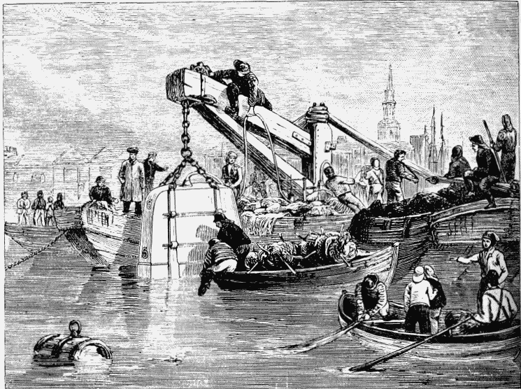
DIVING-BELL USED IN THE CONSTRUCTION OF THE THAMES TUNNEL.
Between the years 1740 and 1750 the manor of Rotherhithe was held by Admiral Sir Charles Wager. Another renowned admiral, Sir John Leake, was born in this parish in 1656, and was buried here sixty-four years afterwards. "Redriff" also long laid claim to brave old Admiral Benbow as a son of the soil. Allen, in his "History of Surrey," says he "was born in Wintershull Street, now called Hanover Street;" curious biographers, however, have discovered that the stout old sailor first saw the light at Shrewsbury. Another wellknown hero, but in a different line of life, Lemuel Gulliver, according to his veracious biographer, Jonathan Swift, was born at Rotherhithe, or, as he styles it, "Redriff"—a fact of which Gulliver doubtless boasted to his courtly friends at Lilliput and Brobdingnag. George Lillo, the dramatist, whose play of George Barnwell was for many years the stock piece performed at our theatres before the pantomime on Boxing-night, is said to have kept a jeweller's shop at Rotherhithe.
The St. Helena Tea-gardens, in Deptford Road, were opened in 1770, and, after undergoing sundry vicissitudes, have more than completed their centenary of existence. A newspaper advertisement in May, 1776, announces that there are "tea, coffee, and rolls every day, with music and dancing in the evening." The place still exists, and is chiefly supported by the lower classes of the neighbourhood, the families of men who work in the docks. In the summer there are brass bands and dancing platforms, singing, tumbling, and fireworks, for the delectation of the merry souls of "Redriff;" but the place has never attained more than a local celebrity, or affected to be a rival of Ranelagh or Vauxhall.
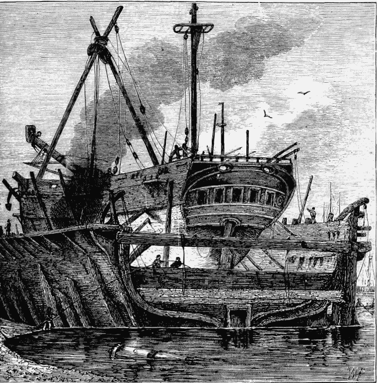
FLOATING DOCK, DEPTFORD (1820).
A notice of Rotherhithe would be incomplete
without at least some reference to that grand
triumph of engineering skill, the Thames Tunnel,
connecting Rotherhithe and Wapping, We have
already spoken at some length of this great work; (fn. 4)
but, nevertheless, a few more words concerning it
may not be out of place here. In 1805 a company
was incorporated as the Thames Archway Com
pany. A shaft was sunk at Rotherhithe, and a
driftway pushed to within 200 feet of the Limehouse shore. Then the water broke in, and the
project was given up. More than fifty engineers
of eminence declared it to be impracticable to construct a tunnel of any useful size beneath the bed
of the Thames. But as much was said afterwards
against carrying a railroad across Chat Moss, and
yet George Stephenson achieved that feat; and
another great engineering genius, Isambard Brunel,
happening, about the year 1814, to observe in the
dockyard at Chatham the little passages bored
through timber by a marine insect, took from it
a hint as to the construction of tunnels. In
course of time he matured the idea. In 1824 a
company was formed, and Brunel set to work, and
with his celebrated "shield," an adaptation and
imitation of the "teredo," or marine worm, began
the great tunnel. There were many mishaps.
Twice the water broke in. Then came want of
funds, and the work was suspended for seven
years. Public subscriptions raised £5,000, and
once more Brunel set to work. On the 25th of
March, 1843, the tunned was opened as a public
thoroughfare, and the successful engineer was
knighted by Queen Victoria. Of the diving-bell
used in the construction of the Thames Tunnel we
give an illustration on page 138. During the suspension of the work, great doubt was often expressed
as to whether the tunnel would ever be completed.
Tom Hood wrote an "Ode to M. Brunel," in
which occur these lines:—
"Other great speculations have been nursed,
Tih want of proceeds laid them on the shelf:
But thy concern, Brunel, was at the worst,
When it began to liquidate itself."
And again—
"Well ! Monsieur Brunel,
How prospers now thy mighty undertaking,
To join by a hollow way the Bankside friends
Of Rotherhithe and Wapping?
Never be stopping;
But poking, groping, in the dark keep making
An archway, underneath the dabs and gudgeons,
For colliermen and pitchy old curmudgeons,
To cross the water in inverse proportion,
Walk under steam-boats, under the keel's ridge,
To keep down all extortion,
And with sculls to diddle London Bridge!
In a fresh hunt a new great bore to worry,
Thou didst to earth thy human terriers follow,
Hopeful at last, from Middlesex to Surrey,
To give us the 'view hollow.'"
We need scarce add that for many years the great work was numbered with the splendid failures connected with the name of Brunel; and the tunnel, which had cost nearly half a million of money, became converted into little more than a penny show. The roadway, which would have made it available for vehicular traffic, it is stated, would have required nearly £200,000 more, and the money was not forthcoming. As this kind of approach has now been formed, the tunnel may be said to have realised its original purpose, though not in the way designed by Sir M. I. Brunel. In 1871 the tunnel was closed for pedestrians, and converted into a railway in connection with the East London line. This railway passes, by a gradual incline from the station of the Brighton and South-Coast line at New Cross, through the market gardens on the south side of Deptford Lower Road. Near the St. Helena Gardens there is a station for the convenience of this rapidlyincreasing district. Thence, passing under the roadway, the line skirts the south-west side of the Commercial Docks, and then shortly afterwards finds its level at the mouth of the tunnel, where there is another station, between sixty and seventy feet below the surface of the ground.
Rotherhithe has been for a considerable period celebrated for its docks. The great dry dock here has existed for nearly two centuries, having been opened in 1696; the great wet dock was finished in the year 1700. After the bursting of the South Sea Bubble in 1720, the directors took a lease of this dock, where their ships, then engaged in the whale-fisheries of Greenland, landed their cargoes of unfragrant blubber. The docks, known as the Commercial, are still used for the same purposes. Adjoining to them are the Great East Country Dock, and several smaller ones. From the situation of these very extensive docks, which include within their boundaries nearly a hundred acres, of which about eighty are water, they might doubtless be made, now that the trade of the port of London has so wonderfully increased, to rank among the most prosperous establishments of the metropolitan harbour.
The Commercial Docks and Timber Ponds, and also the East Country Dock, are now incorporated with the Grand Surrey Canal Dock, the opening of which into the Thames is about two miles below London Bridge. In the Timber Ponds and East Country Docks, timber, corn, hemp, flax, tallow, and other articles, which pay a small duty, and are of a bulky nature, remain in bond, and the surrounding warehouses are chiefly used as granaries, the timber remaining afloat in the dock until it is conveyed to the yards of the wholesale dealer and the builder. The Surrey Dock is merely an entrance basin to a canal, and can accommodate 300 vessels; whilst the warehouses, chiefly granaries, will contain about 4,000 tons of goods. The Commercial Docks, a little lower down the river, occupy an area of about forty-nine acres, of which four-fifths are water, and there is accommodation for 350 ships, and in the warehouses for 50,000 tons of merchandise. They were used originally, as stated above, for the shipping employed in the Greenland fishery, and provided with the necessary apparatus for boiling down the blubber of whales; but the whale fishery being given up, the docks were, about the year 1807, appropriated to vessels engaged in the European timber and corn trade, and ranges of granaries were built. The East Country Dock, which adjoins the Commercial Docks on the south, is capable of receiving twentyeight timber ships, and was constructed about the same period for like purposes. It has an area of about six acres and a half, and warehouse-room for nearly 4,000 tons.
The various docks and basins embraced in the elaborate system belonging to the Surrey Commercial Dock Company are no less than thirteen in number, and are named respectively the Main Dock, the Stave Dock, the Russia Dock, Quebec Pond, Canada Pond, Albion Pond, Centre Pond, Lady Dock, Acorn Pond, Island Dock, Norway Dock, Greenland Dock, and South Dock.
In all that concerns the bustle of trade and industry, no capital in the world can compare with London. Foreign travellers, like the Viscount D'Arlingcourt, own that the Neva is in this respect as far below the Thames as it is above it in splendid buildings and scenery. "What can be more wonderful," he asks, "than its docks? Those vast basins, in the midst of which are barracked whole legions of vessels, which the sovereign of maritime cities receives daily? These vessels enter thither from the Thames by a small canal, which opens for their admittance and closes after them. The docks are surrounded by immense warehouses, where all the products of the universe are collected together, and where each ship unloads its wealth. It would be impossible, without seeing it, to fancy the picture presented by these little separate harbours in the midst of an enormous city, where an innumerable population of sailors, shopkeepers, and artisans are incessantly and tumultuously hurrying to and fro."
"In 1558," writes Mr. Charles Knight in his "London," "certain wharfs, afterwards known as the "Legal Quays," were appointed to be the sole landing-places for goods in the port of London. They were situated between Billingsgate and the Tower, and had a frontage of 1,464 feet by 40 wide, and of this space 300 feet were taken up by landing-stairs and by the coasting-trade, leaving, in the year 1796, only 1,164 for the use of the foreign trade. Other wharfs had, it is true, been added from time to time, five of these 'sufferance wharfs,' as they were called, being on the northern side of the river, and sixteen on the opposite side, comprising altogether a frontage of 3,676 feet. The warehouses belonging to the 'sufferance wharfs' were capable of containing 125,000 tons of merchandise, and 78,800 tons could be stowed in the yards. The want of warehouse room was so great that sugars were deposited in warehouses on Snow Hill, and even in Oxford Street. Wine, spirits, and the great majority of articles of foreign produce, especially those on which the higher rates of duties were charged, could be landed only at the Legal Quays. In 1793 sugars were allowed to be landed at the sufferance wharfs, but the charges were higher than at the Legal Quays; extra fees had to be paid to the revenue officers for attendance at them, though at the same time they were inconveniently situated, and at too great a distance from the centre of business. The above concession to the sufferance wharfs was demanded by common sense and necessity, for the ships entered with sugar increased from 203 in 1756, to 433, of larger dimensions, in 1794. Generally speaking, the sufferance wharfs were used chiefly by vessels in the coasting trade, and for such departments of the foreign trade as could not by any possibility be accommodated at the Legal Quays. Even in 1765 commissions appointed by the Court of Exchequer had reported that the latter were 'not of sufficient extent, from which delays and many extraordinary expenses occur, and obstructions to the due collection of the revenue.' But the commerce of London had wonderfully increased since that time, its progress in the twenty-five years, from 1770 to 1795 having been as great as in the first seventy years of the century." Among the various plans for docks, quays, and warehouses, which were drawn up at the end of the last century, with the view of remedying the evils spoken of above, was one which displayed considerable ingenuity, and consisted, in fact, of four distinct projects:—1. To form a new channel for the river in a straight line from Limehouse to Blackwall; the Long Reach round the Isle of Dogs thus constituting a dock with flood-gates at each entrance. 2. To continue the new channel below Blackwall towards Woolwich Reach, so as to convert another bend of the old channel into a dock. 3. To make a new channel from Wapping, and to form three docks out of the three bends, to be called Ratcliffe Dock, Blackwall Dock, and Greenwich Dock. The Trinity House objected that the King's Dock at Deptford would be injured by the latter plan, on which it was proposed—4. To make a new channel from Wapping to the old channel between Greenland Dock (now the Commercial Docks) and Deptford, thence inclining to the northward until it opened into Woolwich Reach, thus forming two spacious docks out of the bends of the river (above and below) at Blackwall.
The Commercial Docks have an entrance from the Thames, between Randall's Rents and Dogand-Duck Stairs, nearly opposite the King's Arms Stairs in the Isle of Dogs. They are the property of the Surrey Commercial Dock Company. A considerable extension of their area has been made within the last few years, with a view to meeting the increased requirements of the timber trade in the port of London, by the addition of a new dock which has been named the Canada Dock. It is 1,500 feet in length, 500 feet in width, and has a water area of sixteen acres and a half. It communicates with the Albion Dock by an entrance fifty feet in width, and the quay space around is upwards of twenty-one acres in extent.
On the river-side of the Commercial Docks, just below Rotherhithe Church, at the bend in the river forming the commencement of Limehouse Reach, is "Cuckold's Point," which was formerly distinguished by a tall pole with a pair of horns on the top, and concerning which a singular story is told. From this point of the river, lying away to the right above Greenwich, is seen the village of Charlton, with which the tradition is connected. The manor-house there, of which we shall have more to say presently, although built only in the reign of James I., was long called King John's Palace by the country people, who doubtless confounded it with the old palace at Eltham in the vicinity, which, however, was not itself in existence in King John's day. "The Charlton people, however," writes Dr. Mackay in his "Thames and its Tributaries," "cling to King John, and insist that their celebrated Horn Fair, held annually on the 18th of October, was established by that monarch. Lysons, in his 'Environs of London,' mentions it as a vague and idle tradition; and such, perhaps, it is; but, as we are of opinion that the traditions of the people are always worth preserving, we will repeat the legend, and let the reader value it at its proper worth. King John, says the old story, being wearied with hunting on Shooter's Hill and Blackheath, entered the house of a miller at Charlton to repose himself. He found no one at home but the mistress, who was young and beautiful; and being himself a strapping fellow, handsome withal, and with a glosing tongue, he, in a very short time—or as we would say in the present day, in no time—made an impression upon her too susceptible heart. He had just ventured to give the first kiss upon her lips when the miller opportunely came home and caught them. Being a violent man, and feeling himself wounded in the sorest part, he drew his dagger, and rushing at the king, swore he would kill them both. The poet of all time hath said, 'that a divinity doth hedge a king;' but the miller of Charlton thought such proceedings anything but divine, and would no doubt have sent him unannealed into the other world if John had not disclosed his rank. His divinity then became apparent, and the miller, putting up his weapon, begged that at least he would make him some amends for the wrong he had done him. The king consented, upon condition also that he would forgive his wife, and bestowed upon him all the land visible from Charlton to that bend of the river beyond Rotherhithe where the pair of horns are now (1840) fixed upon the pole. He also gave him, as lord of the manor, the privilege of an annual fair on the 18th of October, the day when this occurrence took place. His envious compeers, unwilling that the fame of this event should die, gave the awkward name of Cuckold's Point to the river boundary of his property, and called the fair 'Horn Fair,' which it has borne ever since." Peter Cunningham, in his "Handbook of London," thus gives his version of the story:—"King John, wearied with hunting on Shooter's Hill and Blackheath, entered the house of a miller at Charlton to refresh and rest himself. He found no one at home but the miller's wife, young, it is said, and beautiful. The miller, it so happened, was earlier in coming home than was usual when he went to Greenwich with his meal; and red and raging at what he saw on his return, he drew his knife. The king being unarmed, thought it prudent to make himself known, and the miller, only too happy to think it was no baser individual, asked a boon of the king. The king consented, and the miller was told to clear his eyes, and claim the long strip of land he could see before him on the Charlton side of the river Thames. The miller cleared his eyes, and saw as far as the point near Rotherhithe. The king then admitted the distance, and the miller was put into possession of the property on one condition—that he should walk annually on that day, the 18th of October, to the farthest bounds of the estate with a pair of buck's horns upon his head." Of this tradition our readers may believe as much, or as little, as they please. "Horn Fair," adds Mr. Cunningham, "is still kept every 18th of October, at the pretty little village of Charlton, in Kent; and the watermen on the Thames at Cuckold's Point still tell the story (with many variations and additions) of the jolly miller and his light and lovely wife." The horns, we need scarcely add, have long disappeared from Cuckold's Point, and the disreputable fair formerly held at Charlton has, fortunately, now become a thing of the past.
Taylor, the "water-poet," makes mention of the
above tradition in the following lines:—
"And passing further, I at first observed
That Cuckold's Haven was but badly served:
For there old Time hath such confusion wrought,
That of that ancient place remained nought.
No monumental memorable Horn,
Or tree, or post, which hath those trophies borne,
Was left, whereby posterity may know
Where their forefathers' crests did grow, or show.
Why, then, for shame this worthy port maintain?
Let's have our Tree and Horns set up again,
That passengers may show obedience to it,
In putting off their hats, and homage do it.
But holla, Muse, no longer be offended;
'Tis worthily repaired and bravely mended."