Survey of London: Volume 26, Lambeth: Southern Area. Originally published by London County Council, London, 1956.
This free content was digitised by double rekeying. All rights reserved.
'Norwood: Introduction', in Survey of London: Volume 26, Lambeth: Southern Area, (London, 1956) pp. 167-173. British History Online https://www.british-history.ac.uk/survey-london/vol26/pp167-173 [accessed 18 April 2024]
CHAPTER VII - Norwood
South of Tulse Hill and Brockwell Park lies Norwood, a name derived from the North Wood which formerly covered the hilly country of north Croydon and the southern parts of Lambeth. The Lambeth portion of Norwood comprises West (formerly Lower) Norwood and part of Upper Norwood; it consists of a number of low hills, Knight's Hill, Salter's Hill, Gipsy Hill, which slope gently up to the ridge along which runs the road from Streatham to Sydenham. Until the beginning of the 19th century the area was remote and inaccessible, the roads from the north tapering off into winding tracks; indeed the name Norwood is itself a reminder that it had closer connection with Croydon than with Lambeth or London. As late as 1802 a hermit known as “Matthews the hairyman” lived in the wood in a cave or “excavated residence”. (fn. 1) The neighbourhood was so lonely that at about the same date Dr. Leese, who lived on Central Hill, used on winter nights to “fire off a pistol to let people know he had firearms in the house”; (fn. 2) even in the 1840s Norwood Lane (now Road) was so unfrequented that it provoked the dread of a youth walking home from his work in London. (fn. 3)
About three-quarters of the Lambeth portion of Norwood, including all the area south of St. Luke's Church, formed part of the Archbishop of Canterbury's Manor of Lambeth. The remaining quarter consisted of two pieces; one, bounded by Norwood Road, Croxted Road and part of Thurlow Park Road, was a detached portion of the parish of Streatham and of the Manor of Leigham Court, the rest of which lay in Streatham; the other, approximately bounded by Leigham Vale, Norwood Road, the parish boundary and a line parallel with and about one hundred yards south of Canterbury Grove, formed the bulk of the small Manor of Levehurst.
Much of the Archbishop's land in Norwood was wooded until the 18th century. Gipsy Hill gets its name from the gipsies who encamped in the woods there for many years and to whom Pepys may refer in the following entry: “This afternoon my wife and Mercer and Deb went with Pelling to see the gypsies at Lambeth, and have their fortunes told; but what they did, I did not enquire”. (fn. 4) The Gipsy House stood on the north side of the railway near Oaks Avenue. At the time of the Parliamentary Survey in 1647 that part of the wood in Lambeth covered some 300 acres with about 6,300 trees, but many of them were felled in the next 150 years. They were mostly pollard oaks which were lopped every 30 years; the herbage, bushes and thorns belonged to the tenants of the Manor. Within the wood were three inclosed coppices, Elderhall coppice, Great Clayland coppice and Little Clayland coppice, covering about 130 acres at Salter's Hill and Gipsy Hill. These three coppices were felled at ten years’ growth and then inclosed for seven years; “And then the commoners have had their common therein for three yeares till ye next fall”. (fn. 5)
At the south-eastern corner of the parish, where Westow Hill and Crystal Palace Parade now meet, stood the Vicar's Oak, “an ancient remarkable tree” which still stood in 1647, but which was probably felled soon afterwards. (fn. 6) The tree marked the junction of four parishes— Lambeth, Croydon, Camberwell, and a detached portion of Battersea—and was a favourite spot for the inhabitants of Lambeth to pause for refreshment when they beat the bounds of the parish; in 1586–7, for instance, the churchwardens spent 2s. 6d. “for makinge honest men drinke when we went to vicars oke in perambulacion”. (fn. 7) The tree was so famous that the term “Vicar's Oak” survived as a place-name until well into the 19th century.
The south-west extremity of the parish was much more open; the Parliamentary Survey of 1647 only mentions a small common wood called Knight's Hill, containing 40 pollard oaks and two elms, (fn. 5) while to the west of St. Luke's Church there was a heath called Little Blabbs Heath. (fn. 8)
The land between St. Luke's Church and Herne Hill was formerly part of the area known as Lambeth Dean. The history of this district, and of the rest of Norwood lying in Lambeth parish is greatly complicated by the existence of two areas both called Knight's Hill. The southerly Knight's Hill formed part of Lambeth Manor and lies to the south of St. Luke's Church, while the other comprised the detached portion of the Manor of Leigham Court and of the parish of Streatham mentioned above, and lies between Norwood Road and Croxted Road. The confusion dates from the 16th century when both areas were occupied by members of the Knight family, who held a great deal of land in Lambeth and Streatham. The Manor of Leigham Court lay in the latter parish, and its descent has been traced in the Victoria County History of Surrey. (fn. 9) Only the detached portion referred to above, containing some 160 acres, falls within the area covered by the present volume. In the 16th century it was part of the copyhold of the Manor of Leigham Court, and was usually held with an adjoining capital messuage which formed part of the copyhold of Lambeth Manor. (fn. 10) In 1786 the Manor of Leigham Court was held by the Duke of St. Albans. (fn. 9)
On the south side of the Knight's Hill belonging to Leigham Court lay the Manor of Levehurst, which in 1471 was held by Ralph Leigh (Legh). (fn. 11) In 1543 Sir John Leigh conveyed Levehurst and Stockwell Manors and certain copyhold lands in Lambeth Manor to Henry VIII. (fn. 12) Unfortunately Sir John Leigh had no right to sell the copyhold, for he had a younger brother, Ralph, to whom by the custom of Lambeth Manor it rightly belonged. In 1552 the Archbishop obtained a decree of the Court of Augmentations returning this land to him, (fn. 13) Levehurst remained in the hands of the Crown, but the position must have been obscure even then, for in 1563 a Commission was set up to inquire whether the lands conveyed by Sir John Leigh to Henry VIII had been held by him as freehold or as copyhold of the Archbishop's Manor of Lambeth. The jury empanelled by the Commissioners described the boundaries of Levehurst (fig. 56) and reported that Sir John Leigh had held the Manor subject to a rent of 10s. per annum to the Archbishop; but they could not say whether the adjoining land belonging to the Archbishop was freehold or copyhold, or even by what right parts of it were held. (fn. 14) A likely cause of their doubt may have been that much of the land in dispute was recently-felled woodland whose boundaries had hitherto not been accurately defined.
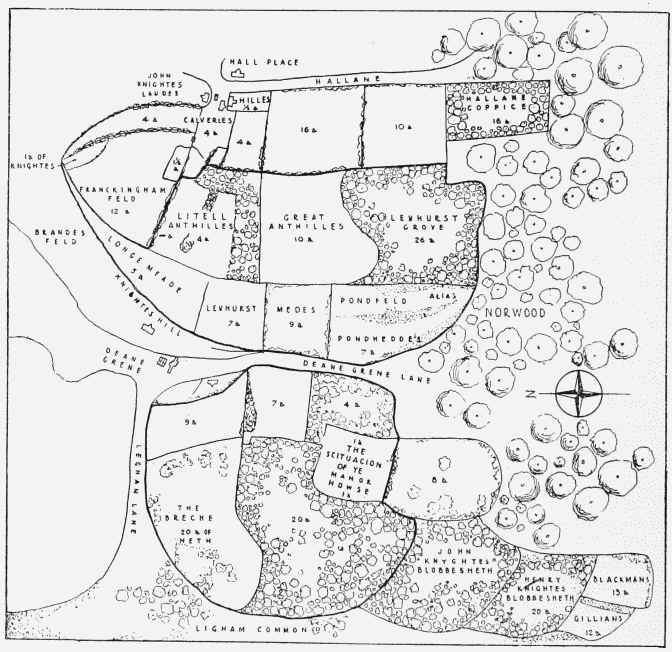
Levehurst Manor in 1563; re-drawn from a map in the Public Record Office
Two years later Queen Elizabeth granted Levehurst to Richard Barnard and Robert Taylour, (fn. 15) who in 1566 conveyed it to Sir Richard and Lady Wenefride Sackville. (fn. 16) In 1578 their son Sir Thomas Sackville conveyed it to Dr. Robert Forth, (fn. 17) and his son Thomas sold the greater part of it to Samuel Weller in 1600. (fn. 18) In 1616 William Weller conveyed this portion to John Bingham, (fn. 19) and in 1628 the latter's brother William sold it to Thomas Overman. (fn. 20) In 1703 another Thomas Overman and his wife Mary conveyed it to Samuel Lewin. (fn. 21) In 1744 it was in the possession of James Wall. (fn. 22)
That part of Levehurst Manor which lay on the east of Norwood Road was conveyed by Thomas Forth to Henry Dalton, citizen and joiner of London, in 1600. (fn. 23) George Dalton conveyed it to Christopher Woodward, citizen and vintner of London, in 1616. (fn. 24) This land descended to Christopher Woodward's grandson Edward, upon whose death in 1725 it was divided. Subsequently James Wall bought up both interests in 1731 (fn. 25) and 1744, (fn. 26) so that by the latter date the whole Manor had been reunited.
In addition to acquiring Levehurst Manor, James Wall acquired a large copyhold estate in the adjoining parts of Lambeth Manor. In 1733 he was admitted to some 124 acres in the southwest part of the Manor, comprising Blackmans and Julians (the latter name being still in use in St. Julian's Farm Road), Little Blabbs Heath and Fuzzey Field or Oxenleys, and to some 52 acres called Berrys Grove and Colwood coppice lying in the area between the south side of the South Metropolitan Cemetery and the eastern boundary of the parish. (fn. 27) In 1745 Wall was also admitted to the greater part of the remaining land between Norwood Road, Croxted Road and Knight's Hill, including two fields known as “Anthills”. (fn. 28) These last and Berrys Grove, which was formerly known as Levehurst Grove, had in the 16th century been part of Levehurst Manor, (fn. 14) but had subsequently become incorporated in the Manor of Lambeth.
The Wall estate was, however, soon superseded by an even larger one whose history coincided with the beginning of the development of modern Norwood. In 1772 Edward (later Lord) Thurlow was admitted to Knight's Hill House and 100 acres of copyhold land in Lambeth Manor between Norwood Road and the south-west side of Knight's Hill. (fn. 29) This land formed the nucleus of the vast estate in Lambeth and Streatham which Lord Thurlow acquired during the next 23 years. In 1778 he took a lease from the Duke of St. Albans of the Knight's Hill which formed a detached portion of the Manor of Leigham Court, and in 1785 he bought this land, comprising some 160 acres and then called Brockwell Green Farm, (fn. 30) for £3,255. (fn. 31) Two years later he was admitted to the entire copyhold estate held by the Wall family in Lambeth Manor. (fn. 32) In 1789 he bought the Manor of Leigham Court in Streatham (the detached portion of which he had already acquired in 1785) from the trustees of the late Duke of St. Albans, (fn. 30) and in 1795 he rounded off his enormous property by acquiring Levehurst Manor from James Wall, junior, a Lieutenant in the Navy. (fn. 22) The entire estate comprised 594 acres of freehold in Streatham, 355 acres of copyhold in Lambeth Manor, 123 acres of freehold in Lambeth and 48 acres of land allotted after the Lambeth Manor Inclosure Act of 1806. (fn. 33)
Lord Thurlow (1731–1806) was one of the most eminent lawyers of the late 18th century. He became Solicitor-General in 1770, Attorney-General in 1771, and was Lord Chancellor from 1778 to 1792 (except for the short period of the Fox-North Coalition). His distinguished appearance made him the victim of Charles James Fox's famous remark that “no man ever was so wise as Thurlow looks”. (fn. 34)
Near the junction of Thurlow Park Road and Elmcourt Road Lord Thurlow built a large mansion designed by Henry Holland (Plate 44c). Thurlow did not mean to spend more than £6,000, but Holland built an “ill executed” house costing about £18,000. (fn. 35) The two men quarrelled and the house, which was built between 1792 and 1795, was finished by Samuel Wyatt of Chelsea, “architect and builder”. (fn. 36) Lord Thurlow never moved into the house, but continued to live at Knight's Hill Farm, a very much smaller house near Norwood Road. Lord Chancellor Eldon told the story that, as Lord Thurlow was coming out of the Queen's Drawing Room, a lady “asked him, when he was going into his new house? ‘Madam’, said he ‘the Queen has just asked me that impudent question; and as I would not tell her, I will not tell you’ ”. (fn. 37)
The development of modern Norwood may be said to date from 1806, the year in which the Lambeth Manor Inclosure Act was passed and Lord Thurlow died. By his will (fn. 38) Lord Thurlow devised his entire property in Lambeth and Streatham to trustees to sell. The trustees at once tried to sell the mansion and part of the land, but no purchasers came forward. They therefore obtained an Act of Parliament in 1809 empowering them to demolish the mansion, to sell or lease the land, and to make certain roads to accelerate building in the area. (fn. 39)
Under the terms of this Act Norwood Road was improved, and what are now Leigham Vale, Canterbury Grove and Palace Road were built. Meanwhile in their Award of 1810 (fn. 40) the Lambeth Manor Inclosure Commissioners provided for the inclosure of Norwood Common and for the construction of the roads now known as Norwood High Street, Elder Road, Chapel Road, Gipsy Road, Salter's Hill and Gipsy Hill. In 1810 the trustees of Lord Thurlow started to disperse their estate and put up 160 acres of land for sale by auction. (fn. 41) This process went on gradually, the sales being sometimes by private treaty but usually by auction, until 1846, when all the Lambeth property had been sold. (fn. 42) The mansion was demolished in 1810, and the materials sold for £7,230. (fn. 43) Thus between 1806 and 1810 the fundamental obstacles to the development of Norwood had suddenly been removed; the Common had been divided amongst individual owners, greatly improved access had been provided, and the break-up of the principal estate had begun.
Most of the houses which were built in the area immediately after the Award of 1810 were cheap and small, probably because the Archbishop had no power to grant long leases on his own property, nor was he able to grant copyholders licence to demise their property for more than 21 years. A few of these unremarkable houses survive in a much mutilated condition in Norwood High Street. By two Acts of Parliament of 1824 and 1825, (fn. 44) however, the Archbishop was enabled to provide the necessary security of tenure for a better type of development, and no doubt the decision of the Lambeth Church Building Committee to erect St. Luke's Church (consecrated in 1825) in what was still open country provided an additional attraction for the wealthier classes. Between 1824 and 1843 a line of houses similar to those being erected at Tulse Hill, Herne Hill and Denmark Hill was built on the north side of Crown Lane; (fn. 45) all of them have now been demolished. On the west side of Knight's Hill there were two houses on an even grander scale. Both have now been demolished; both were originally erected in the 18th century but the more northerly one was entirely rebuilt shortly before 1840, when it became known as St. John's Lodge (Plate 45). A description of it written in 1884 (fn. 46) on the eve of its final demolition illustrates the lavish scale on which wealthy business-men lived in the 19th century. The house stood in 21 acres of ground and commanded extensive views. On the ground floor there were two drawing rooms, a dining room, morning room, library, conservatory, two kitchens and a servants' hall; on the first floor there were ten bed chambers, and four more on the upper floor. Outside there was a coachhouse, granary, two cottages, a lodge and stabling for six horses. There was also a farmyard with cow houses, piggeries, fowl houses and mushroom houses. The garden included a lake with an island, a boat house, summer house, heated peach houses, tennis lawn, an Italian garden, a rosery, a pheasantry, asparagus beds, two vineries, melon grounds, a fish reservoir and three kitchen gardens. The house was at first occupied by Bazett David Colvin, (fn. 47) an East India Agent, (fn. 48) and after 1850 by Thomas Tredwell, a railway contractor of the firm of Tredwell Brothers in Parliament Street. (fn. 49) The house and grounds were sold by auction in 1884; the house was shortly afterwards demolished and the entire area covered with small houses. Portobello House, the more southerly of the two, and its grounds suffered a similar fate when the Lambeth Borough Council made use of the site for a housing estate in 1949. (fn. 50)
St. John's Lodge, Portobello House and the houses in Crown Lane all finally succumbed before the inexorable advance of later and more modest development. Another part of Norwood was the scene of an ambitious scheme which never got under way at all. In 1825 George Mills of Norwood bought the Manor of Levehurst, which then contained 94 acres, from Lord Thurlow's trustees. This area was bounded by Leigham Vale on the north, Norwood Road on the east, the parish boundary on the west and a line parallel with and about 100 yards south of Canterbury Grove on the south. In the following year Mills sold (at considerable profit) the bulk of this land to John Wilson, builder, and the remainder to Allen Perring. (fn. 22) By this time the plan for the layout of the roads now known as York Hill, Lansdowne Hill, Royal Circus and the eastern part of Knollys Road had been settled (fig. 57) and Wilson very probably built them; they had certainly been built by 1843. (fn. 45) Wilson at once mortgaged his property and built and disposed of a number of houses; in 1834 he sold his entire interest to his mortgagee, who died three years later. The whole area was then sold off in small lots. (fn. 22)
The significant point in this otherwise totally undistinguished piece of development was the idea of building a circus. Royal Circus stood in a superb position on top of a steep hill, and in the late 1820s a speculator may well have thought that he could attract wealthy people to live there as Dr. Edwards was already doing at Tulse Hill. Unfortunately he did not realize that the advent of the detached or semi-detached suburban house in the early 19th century had already killed the use of the circus in suburban development. Royal Circus proved a complete fiasco. In 1860 it still contained only three houses, all detached, and building along the other estate roads had been at a standstill for nearly twenty years. The steepness of the hill may have discouraged purchasers; the railway which was opened in 1856 and ran round the north-east side of the hill must have provided a further deterrent. The development of the estate was not completed until the early 20th century. (fn. 51)
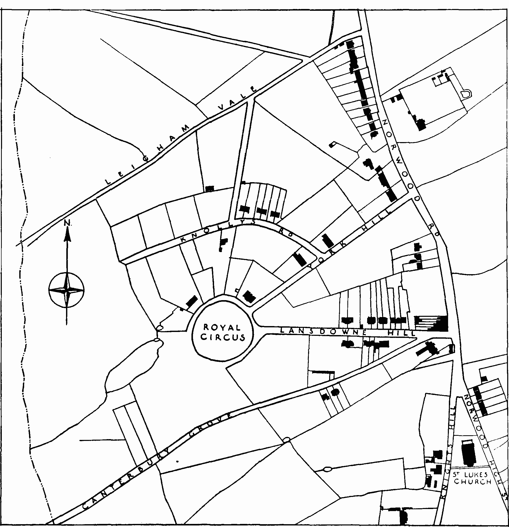
Royal Circus area in 1843, lay out plan
The rapid development of Norwood began shortly after the opening of the West End of London and Crystal Palace Railway in 1856. In 1851 the population of the district of St. Luke's, Norwood, was 3,977, and there were 647 houses. (fn. 52) By 1901 the population had increased nearly tenfold to 35,888, and there were 6,431 houses. (fn. 53) (The figures for 1901 include Knight's Hill and a small part of Tulse Hill not included in the return of 1851.) The demand for land became so great that in 1857 a jury valued at £500 some two acres of land which the railway company wished to acquire and which the owner had bought for only £60 in 1839. (fn. 54) Detailed treatment of the vast quantity of building which took place in the second half of the 19th century is impossible, but a few points of general interest may be noted.
Much of the land sold by Lord Thurlow's trustees between 1810 and 1846 was bought by successful London business-men. In Norwood one of the largest of these commercial investors was John Roupell, a lead-ash smelter of Cross Street, Blackfriars Road; (fn. 55) the occupations of other purchasers include those of pocket-book maker, gunmaker and several “merchants”. Some of the purchasers styled “gentlemen” prove on further investigation to have a commercial origin, such as “tripe butcher”.
These were the people who often became the landlords of the second half of the 19th century. In the case of copyhold land capable of development before about 1850, the owner obtained a licence to demise from the manor court and then let all or part of it to a builder; when the houses were finished, he granted a lease varying usually from 24 to 99 years to the builder's nominee.
From about the middle of the century, however, land was often enfranchised before development began. An act of 1841 established Copy-hold Commissioners with whose consent Lords of Manors might enfranchise copyholders upon receipt of a lump sum payment. (fn. 56) That enfranchised land was considered a better foundation for development than copyhold is shown by the fact that in 1843 R. P. Roupell was willing to pay £1,239 for the enfranchisement of 55 acres. (fn. 57) In the following year Lord Thurlow's trustees paid £2,845 for the enfranchisement of the remaining 156 acres of their estate; (fn. 58) a plan providing for the building of what are now Rosendale Road (as far south as Park Hall Road only), Thurlow Park Road. Lancaster Avenue and Park Hall Road was then drawn up, and the entire area was sold in freehold lots in 1845 and 1846. (fn. 42)
The size of estates ready for development varied greatly. Whatever the extend of their operations may have been, many landowners and builders seem to have lacked a sense of their own limitations—usually financial. In 1868 there were over thirty firms of builders in Lower (now West) Norwood, (fn. 59) most of them probably quite small businesses without the necessary capital to undertake large contracts; bankruptcies were exceedingly common, and many of them must have been caused by excessive ambition.
Norwood provides a spectacular example of catastrophe overtaking a landowner. The Roupell Park estate, whose two main arteries were Christchurch Road and Palace Road, was formed out of the former Thurlow estate and lay in Lambeth and Streatham. It was merely one of several estates in the Home Counties which were acquired by John Roupell and his son Richard Palmer Roupell. The latter had for many years lived with a woman by whom he had several illegitimate children; one of these, William Roupell, had managed the estates in Streatham and Lambeth on a grand scale with their own brick-works. Subsequently, however, R. P. Roupell had married his mistress and had a legitimate son, Richard. Upon his father's death in 1856, William Roupell forget a will by which the entire property (valued at over £200,000) was left to his mother, with himself as sole executor. In 1857 William Roupell was elected one of the Members of Parliament for Lambeth, but five years later suspicions of his deception were aroused and he fled to Spain. He returned voluntarily after a few months and in September, 1826, he was convicted of forgery at the Old Bailey and sentenced to penal servitude for life. (fn. 60)
Land companies and building societies which actually built houses for their members were also active in Norwood in the second half of the 19th century, though the scope of their work in this area was small compared with that of private landowners. In 1867, for instance, the London and Suburban Building Society was erecting five pairs of villas costing £6,745 (fn. 61) (these houses have not been identified), and in 1871 the United Land Company was laying out roads in Gipsy Hill. (fn. 62) At a humbler level on the social scale the Lower Norwood Co-operative Building Company erected working-class cottages on the Elm Grove estate, now known as Dunbar Street. The land on which these houses stood was formerly copyhold of Lambeth Manor but had been enfranchised before the Company bought it. (fn. 63) The first houses were built in 1865. Each pair contained four lettings with separate entrances, and cost £330, so that each letting cost £82 10s. (fn. 64) (Plate 73c, fig. 58.) In general, however, building societies did not play a dominant part in the development of the area until the 1870s, by which time most of them had ceased to erect houses themselves. By advancing money for the purchase of houses they nevertheless played a very important part in the development of Norwood, as of all other Victorian suburbs.
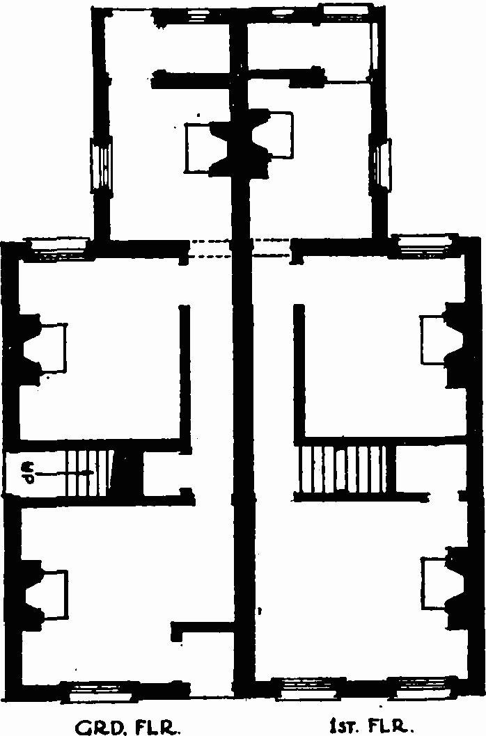
Nos. 25 and 29 Dunbar Street, plan