A History of the County of Stafford: Volume 8. Originally published by Victoria County History, London, 1963.
This free content was digitised by double rekeying. All rights reserved.
'Newcastle-under-Lyme: Introduction', in A History of the County of Stafford: Volume 8, (London, 1963) pp. 1-8. British History Online https://www.british-history.ac.uk/vch/staffs/vol8/pp1-8 [accessed 19 April 2024]
NEWCASTLE-UNDER-LYME
NEWCASTLE-UNDER-LYME, a market-town and parliamentary borough in the northern division of Pirehill hundred, (fn. 1) is situated in the north-west of the county in the undulating country which forms the head-waters of the River Trent. The town grew up around the 12th-century castle which stood in an extensive tract of water fed by the Lyme Brook and other streams descending from the eastern and western ridges. It is on these ridges, rising to a height of 500 ft., that the ancient borough has expanded in modern times, more particularly on the escarpment of the eastern ridge in the direction of the Potteries. The land to the north of the town is also hilly, but towards the south there is a shallow valley through which the Lyme Brook flows to join the Trent at Trent Vale. Geologically Newcastle is situated on a wide strip of barren measures let down by the Apedale Fault, and therefore differs from the contiguous Potteries area. (fn. 2) These measures do, however, contain sandstone once used for building (e.g. St. Giles's church tower), (fn. 3) clays and marls, and ironstone, which have contributed to the town's economic development. (fn. 4) Coal is found principally in the areas to the north and west of the old town which were added to it in 1932. (fn. 5)
In earlier times the town was well supplied with streams, which have now mostly disappeared. The Lyme Brook itself is no longer observable in the urban area, but in the 1870's its course could still be followed for most of the way through the town. (fn. 6) The stream crossed the northern boundary of the old borough just south of Hempstalls, and, after passing under the old canal, itself formed part of that boundary for a short distance. (fn. 7) It continued its course between the east side of Liverpool Road and Hempstalls Lane, passed under the railway from Newcastle to Market Drayton behind a row of houses in Wilson Street, and then under land occupied in part by a timber yard. Subsequently it flowed, mainly through culverts, under Liverpool Road, Bridge Street, and Froghall and past the paper-mill in Holborn. Having entered a culvert by the pool side, it joined near the Pool Dam coalyard another stream running from Ashfield. (fn. 8) This stream, known as the Ashfield Brook, entered the town on Knutton Road and passed parallel with Silverdale Road to the south-west of the castle mound and under the road known as Pool Dam leading to the Higherland. The combined streams, thereafter known as the Lyme Brook, flowed by the Well Steps in a southerly direction to join the Trent, 2½ miles from the town. (fn. 9) Other streams from the Rotterdam to the west and Deansgate to the south helped to maintain the level of the castle pool in medieval times and could still be traced in the 1870's. (fn. 10)
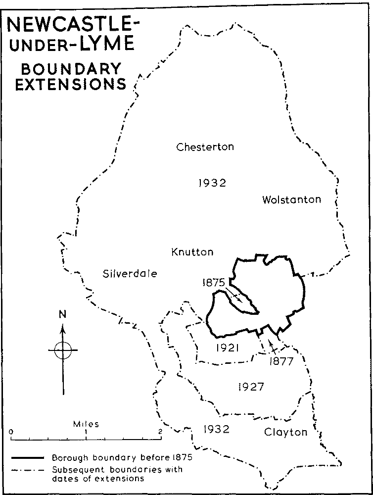
The old borough consisted of 554 acres (fn. 11) and when the new parish of Newcastle was constituted in 1807 (fn. 12) the parochial limits were made to coincide with the municipal boundary. On the east the town was bounded by the parish of Stoke, on the north and west by Wolstanton parish, and on the south by Trentham parish. On the north-west, however, a wedge-shaped area, representing a detached portion of Stoke parish, comprised the castle mound and pool and terminated just beyond Pool Dam, the extreme southern end of which was within the borough. Although under the Reform Act of 1832 this area was included in the parliamentary borough, (fn. 13) it was not until 1875 that this part of Stoke parish was added to the borough for municipal purposes. (fn. 14) In 1877 so much of the township of Clayton Griffith in Trentham parish as adjoined the municipal boundary, being the area now (1959) occupied by the cemetery and the isolation hospital, was also added to the borough, but an attempt at the same time to include a part of Wolstanton was unsuccessful. (fn. 15)
In 1901 an unsuccessful attempt was made to bring within the borough the rest of Clayton, Silverdale, parts of Keele, and Wolstanton, comprising in all 4,772 acres. (fn. 16) In 1921 small portions of Keele (26 acres) and of Clayton (217 acres) were added to the borough, though the corporation had wished to extend the boundaries to include, in addition, Wolstanton, Silverdale, and Chesterton. (fn. 17) In 1927 further parts of Keele and Clayton were incorporated. (fn. 18)
In 1932 a great extension took place, resulting in the absorption of Wolstanton, Chesterton, Silverdale, the rest of the parish of Clayton, and parts of Audley and Keele parishes. (fn. 19) The existing borough thus at a single stride extended its area to 8,882 acres. (fn. 20) Much of it consisted of collieries, brickworks, and tileries, and much of it of agricultural land, some of which has been absorbed by the housing development of the 1930's and of the period after the Second World War. (fn. 21) The borough is now (1959) bounded on the north by the Urban District of Kids grove, on the west by the parishes of Audley and Keele, on the south by Whitmore and Swynnerton parishes, and on the east by the city of Stoke-on-Trent.
The geographical and economic importance of Newcastle arises in the main from its position on the great trunk road which links London and Birmingham with Manchester and the North. It is also on the route from the north-east Midlands and the Potteries to Shrewsbury, Chester, and North Wales. No main railway passes through the town and its development has been to a large extent conditioned by the needs of road traffic on which its viability has largely depended.
NEWCASTLE-UNDER-LYME BOUNDARY EXTENSION
In the early 18th century the post road from London to Lichfield, Chester, Liverpool, and the North ran through Newcastle to Talke-on-the-Hill and then crossed the Cheshire border at Lawton. That part of the road between Tittensor and Talke had become so ruinous that in 1714 a Turnpike Act for its repair and maintenance was passed, and among the trustees were many Newcastle burgesses, including the mayor. (fn. 22) In 1735 the turnpike trust was renewed for a further term of twenty-one years and the trustees included the mayor, justices, and recorder of Newcastle. (fn. 23) When provision was made for further renewal in 1752, the town clerk was added to the list of trustees. (fn. 24) In this way Newcastle was strongly represented on the managing body of the road.
By the middle of the century the town had become the terminal point of five other roads, three of them passing through the growing Pottery towns. The first was the Newcastle-Leek road passing through Wolstanton and Burslem; the second went through Cobridge and Sneyd Green before joining the Newcastle-Leek road at Endon; the third, the NewcastleUttoxeter road, linked Stoke, Fenton, and Longton with the town. (fn. 25) On the southern side two roads existed, one through Seabridge, Whitmore, and Drayton in Hales to Shrewsbury, and the other through Keele, Madeley, and Woore to Chester. (fn. 26) In 1823 or shortly afterwards a new road was constructed from Blackfriars Road (known as Victory Place in the early 1830's (fn. 27) ) to Clayton, Beech, and Eccleshall. (fn. 28)
Until 1763 the flint and clay used in china manufacture, after being landed at Liverpool or Chester, was brought in via Lawton and the turnpike road to Newcastle, whence it proceeded by way of Wolstanton to Burslem and the other Pottery towns. The manufacturers were obliged to use the same roundabout route in the reverse direction for their finished goods. In that year authority was obtained for the creation of a new road from Lawton to Burslem, despite the opposition of Newcastle Corporation which was naturally concerned to preserve the monopoly of the Talke to Tittensor turnpike. (fn. 29)
In 1759 the Newcastle-Uttoxeter road was turnpiked and access to the seaport of Hull was thus made easier for the pottery manufacturers. (fn. 30) In 1779, as a result of an extension of the TittensorTalke road, it became possible to journey from London to Stoke, Burslem, and other places in the Potteries on turnpike roads without touching Newcastle. (fn. 31) With the opening of the Trent and Mersey Canal in 1777 (fn. 32) yet another means of communication became available to the Pottery towns, so that by the end of the century Newcastle had ceased to play an important part in the economic life of the Potteries. It however still retained its importance as a market and coaching town, to which its road system largely contributed. Even the disappearance of the stage coach in the 1830's did not materially weaken its economic status as a marketing centre for a large rural area.
Newcastle was not walled in the Middle Ages. The early settlers no doubt relied on the castle for protection, and it may be that their habitations grew up originally within the outer bailey of the castle. The sites and names of Upper Green and Lower Green give some support to the possibility, and the open character of the former suggests further that it was the site of a primitive market. (fn. 33) The medieval church of St. Giles on its hill above the castle provided another focal point of settlement. A guildhall, presumably in High Street, existed at the end of the 13th century (fn. 34) and the street itself is definitely mentioned in 1326, (fn. 35) while Lower or Nether Street is met with in 1316. (fn. 36) Penkhull Street, the main entrance to the town from the south, appears at least by 1450 (fn. 37) as also does Dog Lane, which traversed Merrial Street and the Ironmarket; (fn. 38) the latter was in existence by the middle of the 14th century. (fn. 39) Its width and that of High Street may indicate market sites. At the eastern end of the Ironmarket marshland, The Marsh of later times, and a large expanse of water known as Colleswaynes Lake (fn. 40) effectively prevented the development of the town in an easterly direction during the Middle Ages.
From a rental of 1608, (fn. 41) compiled to exhibit the chief rents payable to the borough, it appears that at that date the greatest number of houses were to be found in High Street, closely followed by the Ironmarket and Lower or Nether Street, with a substantial number in Penkhull Street. Other streets named in the rental, but containing only a small number of houses, were Bridge Street, Merrial Street, The Green, and Salters Lane—the last known as Hickman Street since at least 1875. (fn. 42) It seems, therefore, that by the beginning of the 17th century most of the town population had moved away from the low-lying neighbourhood of the castle to the higher ground to the east.
In August 1636 Henry, Earl of Huntingdon, passed through Newcastle and noted it as 'a long town, the street [presumably High Street] very broad, ill paved and houses poor thatched and very few either tiled or slated'. He thought the Guildhall 'a fair reasonable town house', but the church 'neither fair nor handsome'. (fn. 43) A plan made in 1691 shows the town to be compact and small, with most of the streets identifiable with their modern equivalents and with the market cross apparently sited in the middle of the High Street. (fn. 44)
For most of the 18th century the street plan was not significantly changed owing in the main to the existence of the circumambient open fields. In one direction, however, within the eastern sector of the old borough boundary, a measure of planned development was achieved. In 1782 the first steps were taken to reclaim The Marsh by enclosing its 23 acres of waste land described as being in a ruinous state. (fn. 45) As a result of the operations of the Marsh Trust the waterlogged area at the eastern end of the Ironmarket was drained to become the existing Nelson Place, from which new streets radiated eastwards and southwards. On the east were Queen Street, King Street, and Brunswick Street, and on the south Bagnall Street, now (1959) Barracks Road. By 1818 all these streets were in existence, as also was Water Street, linking the eastern ends of King and Brunswick Streets, and occupied for most of its length by a large brewery. (fn. 46) By 1834 Hanover Street, joining Queen Street with Hassell Street and traversing King Street and Brunswick Street, had been constructed. (fn. 47)
Until the end of the 18th century the main thoroughfare of the town was not, as might have been expected, the High Street. The highway from Stone and the South entered the town at Stubbs Gate and then proceeded along Goose Street, Lower Street, Holborn, Lower Green, and Upper Green, and thence to the road to Congleton and the North. (fn. 48) This route effectively by-passed the centre of the town, where trade was concentrated, the markets were held, and the principal coaching inns situated. After the Improvement Act of 1819 (fn. 49) the main thoroughfare was re-routed by constructing London Road at the southern approach to the town and Liverpool Street (later Road) at the northern exit, and by 1826–7 the reconstruction had been completed. (fn. 50) Thereafter, in the next fifty years, many buildings, chiefly working-class houses, were put up along and behind these two roads. (fn. 51)
The Inclosure Act of 1816 also affected the geographical development of the town. (fn. 52) The portions of the old open fields allotted to the burgesses in so far as they lay within the old municipal boundary were to the north and west of the town, with a smaller section to the south-east. No building development could take place on these extensive tracts of land (fn. 53) so long as the pasture rights of the burgesses remained intact, and although the 1859 Act (fn. 54) empowered the trustees of the burgesses to grant building leases, they were loth to do so. In the mid1870's much of this burgess land was allotment gardens, and this description still remained true in the late 1920's. (fn. 55) In those parts of the town where inclosure had taken place the opportunity was seized to lay down streets and build houses, and this was particularly true of the north-east quarter. From the mid-19th century the high ground known as The Brampton was developed as the main residential quarter for the professional classes of Newcastle, and many of the villas then built in spacious grounds still survive, though not now occupied in most instances as dwellings. (fn. 56)
During the earlier 19th century when the population of the town doubled (fn. 57) some fifty new streets, most of them consisting of small working-class dwellings, were constructed. (fn. 58) Most of this new development was concentrated in the Liverpool Road area and eastwards from Marsh Parade to the borough boundary. (fn. 59) The latter includes the area between George Street and Mount Pleasant, where the layout of the narrow streets, named after the Royal Dukes, was on the gridiron plan. (fn. 60) The scheme had been started by 1832 (fn. 61) and was evidently intended as a small self-contained unit with shops and public houses at the street corners and a marketplace in the centre. The buildings were almost entirely demolished in 1958. At a slightly earlier period streets of working-class houses were also laid out in the Higherland, particularly on the northern side. (fn. 62) During the 20th century the inhabited area of Newcastle has greatly expanded, particularly since the extension of the borough in 1932. In recent years two major alterations in the centre of the town may be mentioned. For centuries the western end of the Ironmarket had been almost blocked by two large buildings, allowing access to High Street by two narrow lanes, Lad Lane and New Street, but shortly before the outbreak of the Second World War these were removed and an adequate junction with High Street secured. Also at the southern end of High Street buildings have been removed to achieve greater width in the main highway from the South and a more impressive approach to the town.
Changes in street names came into force on 1 January 1954. The principal street through the town from London Road in the south to Liverpool Road in the north had hitherto consisted of Penkhull Street, Market Square, High Street, Red Lion Square, and part of Bridge Street. The whole length of this thoroughfare was renamed High Street and the properties fronting on it were renumbered accordingly. At the same time lower Penkhull Street was included in Brook Lane, Merrial Street was extended to Nelson Place, eliminating the former Marsh Street, and Barracks Road was continued northwards to include Bagnall Street. (fn. 63)
The increase in population and the extension of the built-up area emphasized the need of open spaces for public recreation. Under the Inclosure Act of 1816 5 acres were allotted in The Brampton and The Stubbs to be converted into public walks by the trustees for the burgesses and maintained by them. (fn. 64) The Town Walks, as they were denominated in the Act, were to be laid out into broad footpaths with a plantation of trees and shrubs on each side. (fn. 65) Brampton Walks (now [1959] known as Station Walks) and Stubbs Walks were vested in the corporation in 1835. (fn. 66) In 1877 Stubbs Walks, part of which extends across the city boundary of Stoke-on-Trent, were enlarged, (fn. 67) and ten years later the borough council erected a bandstand there. (fn. 68) In 1897 about 4,000 sq. yds. of freehold land at the south-eastern end of the Ironmarket were bought by public subscription and vested in the corporation. (fn. 69) The area has been known successively as Queen's Garden (fn. 70) and Queen's Gardens. (fn. 71)
Public transport within the borough dates from 1882 when it was decided that the town should be served by trams, though there was great division of opinion whether they should be horse-drawn or steam-driven. (fn. 72) The decision was in favour of steam with the result that the North Staffordshire Tramways Co. extended to Newcastle (fn. 73) the steam tramcar system already in operation in the Pottery towns. (fn. 74) One route entered the borough at the eastern end of Brunswick Street and then proceeded via Nelson Place, Ironmarket, New Street, High Street, and Penkhull Street to its termination in London Road. The second, from the junction in Nelson Place, followed a north-easterly course through Queen Street, Brampton, May Bank, Wolstanton, Port Hill, and Longport to Burslem. A third line went from Pool Dam to Silverdale. (fn. 75)
In 1886 the abandonment of the tramways was authorized, presumably in consequence of the substitution of electrical for steam motive power. (fn. 76) By 1901 an electric tram service was in operation over the old routes and also to Chesterton. (fn. 77) The trams were still running in 1926, though by then the Chesterton and Silverdale lines were being removed. (fn. 78) By 1928 the tramways had been abandoned and had been replaced by buses. (fn. 79) A bus station was erected at The Beeches, Liverpool Road, in 1932. (fn. 80)
Very little information about the population of Newcastle is available before the 19th century. In 1327 a tax on movables was paid by 50 inhabitants, those possessing goods worth less than 10s. and the women and children being exempt. (fn. 81) Five years later another tax list shows 55 payers on movable goods, the exemption limit on this occasion being 6s. instead of 10s. (fn. 82)
In 1563 a Lichfield episcopal return gives the number of households in the town as 78. (fn. 83) The rental of 1608 (fn. 84) probably lists most houses, mentioning about 150. In February 1641/2 289 male inhabitants of Newcastle of the age of eighteen and upwards (fn. 85) took the Protestation Oath. (fn. 86) The Hearth Tax return of 1666 (fn. 87) provides a list of 279 householders, 175 chargeable to tax and 104 exempt. The Compton Census of 1676, (fn. 88) supposedly restricted to persons aged sixteen and over, gives an estimate of 1,000 conformists and 5 nonconformists in Newcastle.
During the 19th century the population steadily increased. In 1801 it was 4,604 and this figure had been doubled by 1841. In 1891 the number of inhabitants was 17,805, nearly four times the 1801 figure. (fn. 89)
Since 1901 the population figures have been: 1911, 20,289; 1921, 20,549; 1931, 23,246; 1951, 70,036. (fn. 90) When the boundary was extended in 1932 the distribution of the population was as follows: Newcastle municipal borough, 23,246 and the added areas, Chesterton, 6,861; Silverdale, 8,662; Wolstanton, 15,002; Clayton, 264; Keele (part of), 478; Audley (part of), 226; giving a total of 54,739. (fn. 91) The population was thus more than doubled, and by 1951, as a result of the development of housing estates, it had increased by a further 15,000. The distribution in 1951 was: Newcastle, 36,198; Silverdale and Knutton Heath, 4,773; Wolstanton, 16,275; Chesterton, 8,017; Knutton, 4,773. (fn. 92)
The position of the town on one of the main routes from London and Birmingham to Liverpool, Manchester, and the North inevitably led to its development as an important coaching station, especially towards the end of the 18th century when the growth of the industrial towns of the Midlands and the North stimulated the movement of passengers and goods. In the early years of the century there were probably no regular stage-coach services to and from Newcastle; in a 1707 list of stage-coach departures from London none was scheduled for Newcastle, though there is mention of a carrier leaving for the town each Monday. (fn. 93) By 1738 a wagon, carrying goods and passengers, was leaving Newcastle every Saturday for London, and in 1756 James Pickford was conveying goods and passengers weekly between London and Manchester via Newcastle. (fn. 94) By the end of the century six coaches, including two mail coaches, passed daily through the town on the London-Liverpool route and four on the Manchester-Birmingham route four days weekly. The Derby Fly on two days a week linked Newcastle with Lincoln through Uttoxeter, Derby, and Nottingham.
In the early 19th century coach services increased rapidly and the advent of the railway saw the stagecoach traffic at its peak. On 6 November 1830 no fewer than 29 coaches passed through Newcastle. (fn. 95) Thereafter coach travel rapidly declined and by 1838 the mail coaches had ceased to pass through the town. (fn. 96) But as late as 1839 the London-Manchester coach and the London-Liverpool coach were still stopping en route at the Castle Hotel. A coach also ran thrice weekly to Derby, but a notification in the same year that an omnibus called there at various hours 'on its way to the rails', i.e. to Whitmore station five miles distant, indicated that the horse-drawn long-distance coach was then almost obsolete. (fn. 97)
The first Newcastle canal was a small local affair. In 1775 Sir Nigel Gresley, Bt., and his son were empowered to make a canal from their coal-mines at Apedale to Newcastle to feed the town with coal. (fn. 98) For a period of 21 years after the completion of the canal the coal was to be sold to the inhabitants of the town and of that part of the parish of Stoke-uponTrent adjoining the Mill Pool at not more than 5s. per ton, and for a further term of 21 years at 5s. 6d. per ton. Since the beginning of the second term (in 1796) the price in fact had been raised to 6s. per ton. (fn. 99) By 1812 both Gresleys were dead and the coal-mines were nearly exhausted. In that year new arrangements were sanctioned. (fn. 100) Commissioners appointed under the Act were empowered to make bylaws rendered necessary by the 'great riots, injuries, and disturbances' that had arisen at the coal wharf over the delivery of the coal. (fn. 101) For six years from 31 July 1812 coal was to be supplied to Newcastle from the Bignall Hill Mines in Apedale at 7s. 6d. per ton and from Ham's Mines, also in Apedale, at 6s. per ton. (fn. 102)
When the Trent and Mersey Canal Bill was under consideration by the House of Commons in 1765, the borough petitioned for a branch to be constructed from the new canal to the town. (fn. 103) The attempt was unsuccessful, presumably for the geographical reason that the high ground between Stoke and Newcastle would have raised serious technical difficulties and the project would have been extremely costly. Thirty years later, however, the link with the Trent and Mersey Canal was effected when the Newcastle Canal Company was formed to make a canal from Stoke to Newcastle. (fn. 104) The new branch left the main canal at Stoke, turned southward and then westward at the end of the hill ridge between the two towns, and finally followed a northward course to its termination in Newcastle at the southern end of the present Brook Lane. (fn. 105) The canal was closed in stages after 1921. (fn. 106)
In 1797 the borough council approved a plan for the construction of a Junction Canal from the Newcastle or Lower Canal to pass through The Stubbs, The Marsh, and The Brampton to join Sir Nigel Gresley's canal 'near the house called the Gate', (fn. 107) and in the following year, an Act having been obtained, (fn. 108) the canal was cut. (fn. 109) The Act also authorized the cutting of a branch canal from Gresley's canal at Apedale to the coal and other works at Partridge Nest and Bignall End. The proprietors, among whom were Josiah Spode and Josiah Wedgwood, were empowered to erect a steam-engine for supplying the canal with water, while special powers were given to them to take the canal through The Marsh and to construct a wharf there; so long as Gresley's undertaking to supply the inhabitants of Newcastle with coal at a limited price persisted (see above), he was allowed to charge an extra 1½d. per ton for freight in respect of coal sold at the wharf. (fn. 110) From its terminal point in Stubbs Field, now Stubbs Walks, near the top of Occupation Street, an inclined railway was made to link up with the head of the Lower Canal. (fn. 111) In this way direct canal communication was effected between the collieries to the west of Newcastle and the Pottery towns.
In 1846 the North Staffordshire Railway Company was empowered to construct a branch line from the main line near Stoke which was to end near the Silverdale Iron Works of Ralph Sneyd. (fn. 112) In 1849 and 1850 Sneyd, seeing no possibility that the Silverdale branch would be brought beyond Newcastle, constructed his own line from his ironworks to Pool Dam, and ten years later it was recognized as a public railway, under the name of the Silverdale and Newcastle Railway. (fn. 113) It was claimed that the establishment of the line had led to the erection of industrial plants and to a great increase in the population of Silverdale. (fn. 114) Half a mile to the south of the Pool Dam terminus was the head of the Newcastle Canal and it was natural that a junction between railway and canal should be sought. Accordingly, between 1850 and 1859 an extension railway was constructed by the canal company between the two points, the wagons containing coal, iron, and ironstone being drawn by horses. (fn. 115)
In 1852 the North Staffordshire Railway brought their line from Stoke via Newcastle to join the Silverdale and Newcastle Railway at Knutton Junction. For a quarter of a mile from Newcastle station the railway was laid on the bed of Robert Heathcote's canal (formerly Gresley's), which had been taken over by the N.S.R., and the goods yard at Newcastle was also made on part of the canal bed. (fn. 116) The passenger station in King Street was opened in September of that year. (fn. 117) In 1856 the Apedale branch from the Silverdale line was opened to serve important collieries to the north and north-west of the town. (fn. 118) In 1864 the canal company agreed to lease their canal and the canal extension railway to the N.S.R., (fn. 119) which had already in 1860 become lessee of the Silverdale and Newcastle Railway. (fn. 120) In the same year the N.S.R. completed its control over the transport facilities in the Newcastle area by taking over the Audley mineral lines and obtaining power to lease Sneyd's railway. (fn. 121) In 1881 the N.S.R. obtained statutory authority for the removal of the restriction whereby horse haulage only should be used on the canal extension railway. (fn. 122)
In the initial stages of the construction of canals and railways the prime consideration had been to facilitate the transit of the heavy mineral traffic of the area, and it was not until 1864 that the needs of passengers were given some priority, apart from the short line from Stoke to Newcastle. In that year the N.S.R. was empowered to extend the Silverdale line to Madeley and thence to Nantwich and Market Drayton and the London & North Western Railway. (fn. 123) A halt where the line crosses Liverpool Road was opened in May 1905 and is still in use. (fn. 124) The line has now (1959) been closed to passenger traffic except for the section from Stoke to Silverdale.
About 1911 a loop railway was projected to run from Trentham along the course of the old Newcastle Canal to connect with the Pool Dam branch. (fn. 125) The First World War held up construction and the project was finally abandoned in 1922. (fn. 126) All that had been built was a bridge carrying the line across the London Road and this was removed for scrap c. 1940. (fn. 127)
The earliest known post office in Newcastle is mentioned in 1734. It was then at the Swan Inn, the innkeeper presumably acting as postmaster. (fn. 128) Other postmasters are mentioned in 1771 and 1781. (fn. 129) In 1791 a post office is mentioned, though not its location. (fn. 130) By 1822 there was a post office in High Street opposite the Guildhall, (fn. 131) probably at no. 41 where in 1836 a postmistress was living. (fn. 132) In 1851 the post office was at 49 High Street (fn. 133) but by 1860 had been moved to Merrial Street. (fn. 134) Until 1854 Newcastle was the head post office of the whole of the Potteries district, but in that year the head office was transferred to Stoke. (fn. 135) From 1835 Tunstall, Burslem, Cobridge, Longport, Hanley, Shelton, Stoke, Longton, and Fenton were served by horseposts from Newcastle, while foot-posts to Longton, Tunstall, and Cobridge were established in the same year. (fn. 136) In 1884 a new office was erected at the corner of High Street and the Ironmarket. By 1888 the old Merrial Street building had been demolished. By 1888–9 the office accommodation was increased by the addition of the adjoining shop, no. 1 High Street. (fn. 137) Since 1914 the General Post Office has stood at the eastern end of the Ironmarket. (fn. 138)
Apart from a royalist plundering raid in May 1644, (fn. 139) Newcastle was not subjected to any military assault during the Civil War, although North Staffordshire formed a narrow gap between the main royalist areas of the West and North which meant that defensive forces had to be concentrated in the neighbourhood of Stone and Newcastle. (fn. 140) The political excitement evoked by the Exclusion Bill produced a strong reaction in Newcastle where the corporation made it clear to the borough members of Parliament that they were in favour of disabling James, Duke of York, and all other Popish pretenders. (fn. 141) In the reaction which followed the failure of the attempt to exclude James from the succession, Newcastle remained impenitent and was the only Staffordshire borough that did not present a loyal address. (fn. 142) In line with their attitude to the Exclusion Bill was the welcome given by the borough to the Duke of Monmouth when he toured the county in 1682. In September he visited the town where, it was reported to the government, 'his reception was above that at any other place . . . for the gentry and young freemen of the town all went on horseback out of town to meet him, and the mayor and aldermen and the rest of the town received him at the town's end on foot. The bells rang all night and many bonfires were made, but [no] wonder, for that town has ever been seditious and there are small hopes of amendment.' (fn. 143)
By 1715 Jacobite sympathizers were in control of the borough council, and in the riot of that year when the dissenters' meeting-house was burnt down (fn. 144) the authorities were thought to have dealt too leniently with the rioters. Henry Hatrell, a Newcastle attorney, (fn. 145) reported that 'the present mayor hath taken very poor bail for the rioters at Newcastle, all not worth £10, and I am told the said mayor charged the constables to take them before nobody but himself'. (fn. 146) This outburst of violence stirred the government to action, and the mayor and the two justices of the peace were arrested and detained in London for some months. (fn. 147) For the rest the borough seems to have concerned itself exclusively with its domestic affairs. If one can detect in its history a leaning towards reform and libertarian movements generally, it is perhaps worthy of remark that as early as 1863 the inhabitants petitioned the House of Commons in favour of votes for women. (fn. 148)
In 1930 the continuance of the borough as a separate entity was endangered by the promotion of the Stoke-on-Trent Extension Bill (fn. 149) which sought to incorporate Newcastle within the limits of that city. Despite strong local opposition—a postcard poll of the local government electors showed a majority of 97.84 per cent against the Bill—the measure was passed by the House of Commons, (fn. 150) only to be rejected by the House of Lords. (fn. 151) In recognition of their part in promoting opposition to the Bill the freedom of the borough was conferred on Lord Dartmouth and Col. J. C. Wedgwood (later Lord Wedgwood), M.P. for Newcastle. (fn. 152)
The best-known natives of Newcastle are Thomas Harrison, the regicide (1606–60), son of Richard Harrison (d. 1653), butcher and four times mayor, (fn. 153) and Philip Astley (1742–1814), the founder of the modern circus. (fn. 154) Newcastle has produced a few inventors of note. In 1713 Thomas Benson invented a flint-grinding machine which was supposed to obviate lung disease among pottery workers, (fn. 155) and Edward Massey (b. 1768) is known as the inventor in 1802 of the patent log for measuring the speed of ships. (fn. 156) A. W. Harrison, late-19th-century photographer, is credited with having produced the first X-ray photographs in this country. (fn. 157)
Joseph Mayer (1803–86), the antiquarian collector, was born at Thistleberry House, the son of Samuel Mayer, mayor in 1833. Although his major benefactions were made to Liverpool, where his extensive collections form part of the public museum, and to Bebington (Ches.) where he established a free library, his native town was not forgotten, (fn. 158) for he founded three university exhibitions tenable by pupils of the High School. (fn. 159) In 1882 he presented to the School of Art a good collection of drawings and prints of the old buildings of the town. (fn. 160)