A History of the County of Gloucester: Volume 8. Originally published by Victoria County History, London, 1968.
This free content was digitised by double rekeying. All rights reserved.
'The borough of Tewkesbury: The growth of the town', in A History of the County of Gloucester: Volume 8, (London, 1968) pp. 118-122. British History Online https://www.british-history.ac.uk/vch/glos/vol8/pp118-122 [accessed 25 April 2024]
Growth Of The Town.
The site of the possible Romano-British settlement is at the north end of the town, near a crossing of the Avon a little above the Long Bridge. From there a road may have crossed the Avon Ham and passed close by the Severn under the Mythe Tute towards Bow Bridge in Twyning, (fn. 1) and it was in the northern end of the town that Romano-British remains were discovered, on the site of the gas-works. (fn. 2) Traces of earthworks were visible in the Saxon period, for the street leading from the middle of the town was called Oldbury Street (later High Street) and the field stretching east from that Street was called Oldbury field. (fn. 3)
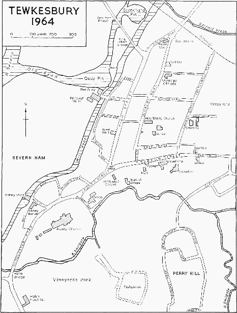
From the 11th century settlement appears to have centred on the point 600 yds. SSW. of the site of the Oldbury, where the roads from north, east, and south meet. There they are also joined by an ancient lane, once called Salters Lane, later Guest Lane, (fn. 4) and afterwards Tolsey Lane. (fn. 5) Later the junction was the traditional place for holding the markets, (fn. 6) and it is likely that they were held there from the time when the market was first established, between 1066 and 1086. (fn. 7) At the junction stood the High Cross, made of stone; (fn. 8) it was recorded in 1540, (fn. 9) and demolished in 1650, the stone being used to repair the Long Bridge. (fn. 10) The High Cross was evidently a simple cross, distinct from the two buildings called the Tolbooth and the Booth Hall, which were recorded in 1487. (fn. 11) In 1540 the Tolbooth was shown to be at the south end of High Street on the east side. (fn. 12) In 1586 the town got a new town hall, (fn. 13) which had a wool solar on the first floor. (fn. 14) It was described c. 1700 as a market cross and town hall, (fn. 15) and in the same period as a very fair market house with a spacious town hall above for courts and public entertainments. (fn. 16) The lower part was evidently open at the sides. (fn. 17)
The ground at this focal point of Tewkesbury, known as the cross, was cluttered with buildings, and the desire to ease congestion may have been one motive for the removal of the High Cross in 1650. More space was cleared in 1752 when the buttermarket house, the cover over 'the king's board', and the stocks were pulled down. (fn. 18) The exact nature of 'the king's board' is not clear, but it was apparently a covered space, called 'the king's place' in 1526, used in connexion with the markets. (fn. 19) In 1788 Sir Christopher Codrington built a new town hall or tolsey in High Street and presented it to the corporation. It was a two-storied gabled building of stone, with a colonnaded lower floor, and was intended for judicial, administrative, and deliberative business. It was set back from the street, and the courtyard in front was intended for a corn market. (fn. 20) In or soon after 1839 the building was enlarged to include a police station, cells, and a fire station, (fn. 21) and the front was brought forward flush with the other buildings in the street. In 1789 a new market hall was built at the cross on the south side of Barton Street, and the old market house, town hall, tolbooth, or tolsey was demolished. (fn. 22) The new market hall went out of use when the markets moved to the area of Station Street to be near the railway line, and its site was taken in 1878 for the new Wesleyan chapel. (fn. 23) After the First World War a memorial cross was placed at the centre of the road-junction.
South-west from the cross the town was for long contained by the abbey and its precinct, and it is likely that buildings reached along Church Street as far as Gander Lane and the Bull Ring (the widening in Church Street where Gander Lane joins it) by the early 12th century when the abbey was founded. On the north-west side of Church Street, where St. Mary's Lane makes a semi-circular loop, and north-east as far as the cranked course of Tolsey Lane, the characteristic pattern of Tewkesbury — long and narrow burgage tenements stretching back from the three main streets, and usually including alleys or elongated courts — is broken. This may indicate that the street pattern of this part had developed haphazard, and was fixed before Queen Maud gave the town its market and its burgesses. In the 20th century the lines of streets and lanes north-west of the abbey remained irregular and confused, though they were far less crowded and cramped than in the 19th century; (fn. 24) in the 16th century there was a maze of lanes there (fn. 25) and the houses were small. (fn. 26) Walker's Lane, recorded in the 13th century, (fn. 27) was an alternative name for the back part of St. Mary's Lane, (fn. 28) and Crispin Lane, recorded in 1509, (fn. 29) was either Bank Alley or the eastern end of St. Mary's Lane. (fn. 30) In addition to Mill Street, Mill Bank, and Wayte Lane, which survived in 1964, the area in 1540 also contained Long Alley (perhaps Old Chapel Court or Chandler's Court), which was important enough to serve as a point of reference, (fn. 31) and apparently Braziers' Lane, (fn. 32) which cannot be identified. The area of St. Mary's Lane underwent a good deal of demolition and rebuilding in the two decades following the Second World War. The assumption that the main road south out of the town in the Middle Ages went along St. Mary's Lane or Mill Street, (fn. 33) and the alternative theory that it went down Gander Lane, have little to recommend them. (fn. 34) The accounts of the abbey's property in 1540 indicate that Church Street followed its modern course and was the main route. (fn. 35)
With expansion on the south-west prevented by the existence of the abbey precinct (part of which, even so, seems to have been used for secular houses) (fn. 36) and by liability to flood, the town's physical growth was northward along High Street and eastward along Barton Street. High Street was called Oldbury Street in 1257 (fn. 37) and is not found as High Street until the 16th century; (fn. 38) both names were used until the mid-19th century. (fn. 39) It held the position of the 'chiefest' street in the 16th century, (fn. 40) and though in 1608 Church Street had a slightly higher number of men on the muster roll and not a noticeably smaller proportion of the wealthier tradesmen, (fn. 41) in 1672 High Street had clearly the highest share of the large houses. (fn. 42) The appearance of Red Lane where it follows the Avon suggests considerable antiquity, and Red Lane is possibly the Eleanor's Lane mentioned in 1393 as running between Oldbury Street and the Avon. (fn. 43) If so, High Street was builtup for virtually the whole of its length by the late 14th century, and on other grounds that is not unlikely. On either side, except for a short stretch at the south end, High Street is flanked by narrow tenements running back, not quite at right angles, on the west to the Mill Avon and on the east to the former Oldbury field. Apart from small alleys, each within the width of the tenement to which it belonged, only Smith's Lane, Quay Lane, (fn. 44) and Red Lane break the street frontage on the west side between the cross and the Long Bridge, and the east side contained no break more than an alley until the 19th century. (fn. 45) At the end of the 16th century one way into Oldbury field was through Little Lilly Croft, at the extreme north end of High Street, and the building of some mean houses there caused an obstruction. (fn. 46)
After houses had filled the whole available frontage of High Street, like that of Church Street, there remained Barton Street, the third of the three main streets comprising the town. Barton Street was less suitable for building than High Street because it is slightly lower and therefore more vulnerable to floods, and on the south side the nearness of the Swilgate prevented the holdings from stretching so far back from the street. Although in 1675 it was suggested that Barton Street was as long as High Street, (fn. 47) 16th-century accounts show that it contained fewer and poorer houses. (fn. 48) In 1608 many fewer inhabitants were returned for Barton Street than for High Street or Church Street, and in general they followed humbler callings. (fn. 49) Timberframed buildings extend along Barton Street only about half as far as along High Street, and in the 18th century Barton Street stopped where Chance Street joins it. (fn. 50) In 1540 there was a gate at the end of Barton Street, and a garden (fn. 51) called the almoner's orchard by it. (fn. 52) Barton Street, so called in 1257, (fn. 53) took its name from the barton or grange of the Earls of Gloucester, (fn. 54) which is likely to have been the building marked as 'tithe barn' in the western angle of Chance Street and Barton Street on a map of 1811. (fn. 55) The barn was presumably the stone-tiled barn of seven bays that housed the gaol of the liberty in 1547, (fn. 56) the stable and grange for the king's horses recorded in 1526, (fn. 57) and perhaps the place in Tewkesbury where the king's horses were kept in 1205 (fn. 58) and 1236. (fn. 59)
The disposition, therefore of the houses of Tewkesbury along the three converging main streets of the town was controlled on the north-west by the Mill Avon and the low-lying Severn Ham, on the north-east by Oldbury field, and on the south by the Swilgate. Back lanes ran along the Avon, the Swilgate, (fn. 60) and apparently along the course of Oldbury Road and East Street, round the south-west corner of Oldbury field. (fn. 61) High Street was built-up for its whole length as far as the water-meadows by the Carrant brook, while land and buildings belonging to the two great estates, those of the abbey and of the honor of Gloucester, the land being, moreover, liable to flood, closed the outer ends of Church Street and Barton Street. The superficial extent of the town, thus confined, remained the same from the later Middle Ages until the early 19th century.
Any increase that was required in the number of houses was achieved by raising the density of building, and particularly by making, behind the houses fronting the main streets, rows of cottages approached by the alleys that had originally given access to the stores, workshops, and gardens at the back. In this way the characteristic arrangement of picturesque but insanitary alleys and courts evolved. By-laws of the early 17th century assumed that every house had a frontage to the street and back premises that were not primarily for habitation, (fn. 62) and most of the houses in the alleys are of the late 17th century or the 18th. Statistical evidence which is stated below suggests a growing population in that period, and the changed pattern of housing may be associated with the replacement of a cloth industry, in which much of the work was done in the master's house, by a knitting industry carried on mainly in the houses of the knitters. The alleys with houses built in them encouraged the poverty-ridden overcrowding that came with an increased population and the town's industrial decline in the mid-19th century. (fn. 63)
The inclosure of Oldbury field in 1811 had made a large new area available for building, close to the centre of the town. Two long streets, Oldbury Road and Chance Street, were laid out parallel to High Street, and two shorter ones parallel to Barton Street. (fn. 64) By 1830 nearly 200 houses had been built in the area, which continued to be called Oldbury or the Oldbury, (fn. 65) and a further 100 by 1850. (fn. 66) The building of New Street between 1828 (fn. 67) and 1842, and of Nelson Street after 1842 along the line of Nelson Alley, (fn. 68) remedied the lack of access between the main streets and the new streets in the Oldbury; the name New Street was changed to Trinity Street after Holy Trinity church at its eastern end, consecrated in 1837. (fn. 69) Sun Alley (the western end of Station Street) was also enlarged, apparently before 1828, (fn. 70) but was still called Sun Alley rather than Sun Street in 1842. (fn. 71) On the other side of High Street Quay Lane was widened in 1843 by demolishing its southern side so that it could carry the railway line to the quay; thereafter it was known as Quay Street. (fn. 72) Apart from the new houses in Oldbury there was in the same period scattered building, including some larger houses, along Barton Road — the extension of Barton Street — where there was already a house called the Folly, near the pound, in 1811; (fn. 73) and a row of houses was built at the end of Church Street. (fn. 74)
There was hardly any new building in Tewkesbury between the 1850's and the 1930's, and a slight fall in the net number of inhabited houses. (fn. 75) The only notable extension in the period was the building of houses along the main road beyond the workhouse, (fn. 76) built 100 yds. south of Swilgate Bridge in 1793. (fn. 77) Before the Second World War some houses were built in the northern part of the Oldbury, and others were built as the first of the estate called Prior's Park, between the Swilgate and the main road to the south. The main development of Prior's Park came after the war, and houses were still being built there in 1964. The estate is mixed, with buildings of one, two, three, and four stories, of varied materials, some built privately and some by the borough council. In 1964 a bridge over the Swilgate was opened to link Prior's Park with a smaller post-war estate called Oldfield, between the Swilgate and Barton Road. (fn. 78) Other post-war housing estates lay further east, on either side of the main road in what was formerly the parish of Ashchurch, and more houses were built in the Oldbury.
A small public park called the Victoria Ground or Gardens, lying beside the Mill Avon below the Abbey Mills, was opened in 1897. (fn. 79) The Vineyards Park, by the Swilgate opposite the abbey church, was acquired by the corporation in 1929. (fn. 80)
Tewkesbury had 66 recorded inhabitants in 1066 and 101 in 1086. (fn. 81) In 1327 the total of 86 people assessed for tax, 65 in the town and 21 in the two hamlets, (fn. 82) was considerably lower than the number of burgesses specified, together with agricultural tenants, in a survey of the Earl of Gloucester's manor in the same year. (fn. 83) In the mid-16th century various estimates gave the number of communicants in the whole of Tewkesbury as 1,600, (fn. 84) 2,000 (fn. 85) and 2,600. (fn. 86) The lowest figure has the look of most accuracy: in 1563 there were said to be 396 households (fn. 87) and in 1603 1,600 communicants. (fn. 88) The estimate of 1,000 families in 1650 (fn. 89) seems too high; 471 houses were assessed for or discharged from hearth tax in 1672, (fn. 90) and a return of 2,001 adults was made in 1676. (fn. 91) The figures nevertheless suggest an increase, and in 1723 a painstaking census showed a population of 2,866. (fn. 92) The population reached 3,000 about the middle of the century, (fn. 93) was 3,768 in 1792, (fn. 94) and rose steadily to 5,780 in 1831. It then levelled off, and from 5,878 in 1851 it fell to 5,100 in 1881. After fluctuating it fell to 4,352 in 1931; the rise to 5,822 in 1961 was attributable only in part to the boundary extension of 1931, and mainly to the building of new houses in Prior's Park. (fn. 95) The foregoing figures include those for the two hamlets, Southwick and the Mythe, which, until the building of the Prior's Park estate in Southwick, contributed very little to the total.
Tewkesbury, 1964
The hamlet of Southwick was recorded in 1086 as one of the group of small estates closely dependent on Tewkesbury. (fn. 96) Southwick was separately tallaged in 1205, (fn. 97) and contained 11 taxpayers in 1327. (fn. 98) In 1662 there were 21 houses assessed for hearth tax, (fn. 99) and in 1841 there were 23 houses. (fn. 100) It is doubtful whether there was ever any settlement of the nature of a village in Southwick; the nearest thing is the scattered group of houses at Lincoln Green on the lane called Tad Lane or Frog Lane in 1544, (fn. 101) but the group of buildings half a mile further south, to which Tad Lane once continued, may have been more of a centre. That is the place marked as Southwick on maps, and although in 1964 it had only a farm-house (Southwick Farm) and a pair of cottages, there were more buildings in 1828. (fn. 102) It was presumably either there or at Lincoln Green that before 1553 three or more messuages lay in fairly close proximity. (fn. 103) For the rest, until the late 19th century Southwick comprised a number of separate houses and cottages. The chief of them is Tewkesbury Park, which with Gubshill Manor and Southwick Farm is described below.
At Gubshill there were two large houses until 1830 or later. Gubshill Manor, however, is the house marked on older maps east of the main road, for until the late 18th century the road ran south and west of Gubshill Manor. (fn. 104) The other house belonged in 1824 to the estate (fn. 105) that included the rectangular moat which survived in 1964 with the name of Margaret's Camp. It may have been the house called the Vineyard, occupied by William Read in 1553 (fn. 106) and perhaps by Giles Read in 1608. (fn. 107) In 1824 it belonged to John Wintle and in 1830 to his widow. (fn. 108) Later record of it has not been found. Half a mile south, beside the main road, stood Stonehouse Farm, where in 1964 there was no sign of any ancient building. Southwick Park, west of Stonehouse Farm and by the Southwick brook, was built in the mid19th century as a large three-story stuccoed villa, on the site of an earlier house; (fn. 109) in 1952 it became the home of Tewkesbury Grammar School. (fn. 110)
In the south-west part of Southwick is Park Farm, formerly Lodge Farm, a square three-story brick building of the 18th century; it has a three-ridged roof and heavy pilasters at the corners, and appears to have been remodelled in the early 19th century. Part of the structure derives from a much earlier building, for repairs in the mid-20th century revealed wattle-and-daub walling near the former front door on the west. (fn. 111) A quarter of a mile west, at Rayer's Hill, a pair of 19th-century Gothick cottages of rubble was falling down in 1964. Near the Odessa Inn on the main road at the southern boundary of the parish (fn. 112) there was in 1964 a holiday caravan site and a small brick farm-house north of it. Cowpen Farm, by the River Swilgate, was built in the mid19th century. Rudgeway Farm, east of the Swilgate, was called Trinity Farm until the 19th century and existed by 1603. (fn. 113) It is an L-shaped timber-framed house of two stories. The ground- and first-floor levels are lower and appear older in the south range than in the north wing. The space beneath the projecting first floor has all been filled, and some panels of the upper story have brick fillings. The house has been altered at least three times since the 17th century.
The extension of Tewkesbury town, described above, has completely changed the character of the north-eastern part of Southwick.
The Mythe, which Domesday Book does not record, was tallaged as a separate vill in 1205. (fn. 114) The name, meaning a river confluence, (fn. 115) befits a tract of land rather than a settlement. In 1327 the vill contained 10 taxable inhabitants. (fn. 116) In 1547 the chief messuage of the Mythe adjoined a chapel, (fn. 117) which may have been a private oratory rather than a chapel of ease. Eight houses in the Mythe were assessed for tax in 1662, (fn. 118) and there were said to be 12 c. 1710. (fn. 119) In 1841 there were 17 houses, (fn. 120) and a high proportion of them were large houses of the villa type: in 1830 there were in addition to the house called King John's Castle six houses described as 'delightful seats'. (fn. 121) There is no evidence that there was ever a nucleated settlement at the Mythe. In 1639 an estate included a parcel of waste called Mythe Green, with a cottage and three closes; (fn. 122) in 1586 a newly built house in the meadow close to the bottom of the hill was recorded; (fn. 123) the Stalls Farm near the northern boundary has a timber-framed barn of the 17th century or earlier. The 'delightful seats' were built widely spaced on the top of the hill at Mythe End and on the slope overlooking Avon Ham and the Avon from the mid-18th century (fn. 124) onward, and relatively large houses continued to be built there up to the mid-20th century. King John's Castle and the house called the Mythe are described below, under the estates to which they belonged. The reservoir and the large red-brick water-tower at the highest point of the Mythe were built in 1889. (fn. 125)