A History of the County of Gloucester: Volume 9, Bradley Hundred. The Northleach Area of the Cotswolds. Originally published by Victoria County History, London, 2001.
This free content was digitised by double rekeying. All rights reserved.
'Parishes: Whittington', in A History of the County of Gloucester: Volume 9, Bradley Hundred. The Northleach Area of the Cotswolds, (London, 2001) pp. 233-248. British History Online https://www.british-history.ac.uk/vch/glos/vol9/pp233-248 [accessed 18 April 2024]
In this section
WHITTINGTON
Whittington is a small rural parish on the edge of the Cotswolds 7 km. ESE. of Cheltenham. The ancient parish, which comprised 1,479 a., (fn. 1) was a thin and elongated band of land extending eastwards from the top of the Cotswold scarp. It was bounded by old tracks and ways on the west and on parts of the south, including the Gloucester—Stow road in the south-east. In 1956 an area on the boundary in the south-east was included in the new civil parish of Andoversford, and Whittington was left with 1,434 a. (fn. 2) (580 ha.). The following account deals with the ancient parish apart from buildings in the south-east belonging to Andoversford hamlet which is included in the history of Dowdeswell given above.
Much of Whittington is on sloping ground rising in places to over 260 m. in the north and to 272 m. in the west at the top of the scarp. The eastern end of the parish is crossed by the river Coln which emerges at Syreford from a narrow valley to flow southwards across more open land at c. 168 m. towards Andoversford. The Whittington brook rising at Puckham, in Sevenhampton, has carved a valley in the west of Whittington, where it has several short tributaries, and continues on its south-eastwards course over flatter land to Andoversford; in its upper part it may have been the stream known as the 'honey bourne' in the early 11th century. (fn. 3) The western end of the parish drains off the Cotswold scarp towards the river Chelt. The flatter parts of the parish lie on the Upper Lias clay or, to the north and west, the overlying Midford Sand, on which Whittington village is built. The hills are formed by an outcrop of the Inferior Oolite (fn. 4) and in places, notably in the north-west at Dodwell (in 1625 Davenport's) hill, (fn. 5) they have been extensively quarried and mined for stone. Gravel has also been extracted in Whittington, from the lower ground near the river Coln.
Although an area at Whalley had been cleared by the early 11th century, (fn. 6) much of the western end of Whittington was probably woodland in 1086, when Whittington manor included a wood measuring a league by ½ league. (fn. 7) In the 13th and 14th centuries woodland on the manor was subject to common rights. (fn. 8) The largest area of ancient woodland in the parish in 1840 was high up in the west and comprised Whittington wood (68 a.) and, on its north, Arle grove (14 a.). (fn. 9) Small plantations of firs on hilltops on the north side of Whittington had been established by the 1770s. (fn. 10) In 1824 Sandywell park in Dowdeswell was extended northwards to the line of a new road being constructed in the south of Whittington; (fn. 11) plantations were created along the northern perimeter of the enlarged park and on spoil heaps thrown up during the road's construction. The total area of woodland in the parish, 87 a. in 1840, (fn. 12) was reduced considerably when Whittington wood, part of the Lawrence family's Sandywell estate, was grubbed up in the early 1860s and the land brought into agricultural use (fn. 13) as Wood farm. (fn. 14) Arle grove, which W. L. Lawrence acquired in 1864, (fn. 15) was left as woodland. (fn. 16) In 1905 the area of woods and plantations in Whittington was given as 37 a. (fn. 17) and in 1986 the area of woodland returned for the parish was 54 a. (22 ha.). (fn. 18)
Eleven tenants were recorded in Whittington in 1086. (fn. 19) Thirteen people were assessed for the subsidy in 1327 (fn. 20) and over thirty-four inhabitants were assessed for the poll tax in 1381. (fn. 21) In 1551 the parish was said to have c. 53 communicants (fn. 22) and in 1563 the number of households was put at 13. (fn. 23) The number of communicants recorded in 1603 was 36 (fn. 24) and in 1650 there were said to be 17 families. (fn. 25) The total population, reckoned c. 1710 to be 126, (fn. 26) was 194 in 1801 and rose to 274 in 1831. After that it fell to 183 in 1871 and, despite an increase in the 1870s, to 179 in 1891. It then rose to 200 in 1911 but was smaller than that in the 1920s and 1930s. In 1951 the use of a military camp in Whittington as a temporary housing estate boosted the population to 265 and in 1961 the population was only 157; part of the decrease was explained by the loss in 1956 of perhaps up to a quarter of the permanent population to the new civil parish of Andoversford. Whittington's population was even smaller in the late 20th century and the number of residents in 1991 was 126. (fn. 27)
Ancient routes in the western part of Whittington may have included the 'port street' mentioned in the early 11th century, (fn. 28) and the parish's western boundary followed an old road from Winchcombe along the top of the Cotswold scarp east of Cheltenham. (fn. 29) Of the ways up the scarp in Charlton Kings (fn. 30) one skirted the top of Ham hill by way of Colgate and in the west of Whittington its irregular course, marking the parish's south boundary, perhaps followed the green way recorded in the early 11th century. (fn. 31) The road was diverted to run straight over the hill in the late 18th or early 19th century. (fn. 32) The place known as 'shaw end', where the Whittington tithingman kept watch in 1394, (fn. 33) was evidently a junction on that route southwest of Whittington village; later a coppice at the junction was called Shaw (or Share) grove. (fn. 34) The road running south from the junction towards Kilkenny, near Upper Dowdeswell, was known as a salt way in the early 17th century. (fn. 35)
The route up Ham hill was also part of a road to Whittington village which, near Whalley Farm, joined a road that once climbed the scarp up Northfield hill. (fn. 36) Further north a road climbing Northfield hill by the house called the Hewletts once descended south-eastwards by way of Puckham Farm in Sevenhampton and at the west end of Whittington village it joined the road from the west by way of Ham hill. Both roads were described as highways in the early 17th century. (fn. 37) From the junction the road continued on an easterly course through the village and the hamlet of Syreford, where it crossed the river Coln, and it provided a way to Northleach joining the Gloucester-Oxford road near Puesdown Ash, in Compton Abdale. (fn. 38) Among abandoned ancient tracks and paths in Whittington is one leading south-eastwards from the village towards Andoversford. (fn. 39)
From 1756 the road through the village was part of a turnpike linking Cheltenham with the Gloucester-Oxford road near Puesdown Ash. In the west of Whittington the turnpike took an indirect route: having climbed Northfield hill by the road past the Hewletts, it turned southwards along the old road which formed part of the Whittington parish boundary and then southeastwards to the junction near Whalley Farm. (fn. 40) In 1786 it was replaced by a new turnpike up the Chelt valley through Charlton Kings and Dowdeswell, and in 1825 a new line of road was opened from that road below Dowdeswell village up to Whittington. The new road of 1825 passed close to the parish church, some way south of the village, before turning southeastwards along the boundary with Dowdeswell for Andoversford. (fn. 41) During its construction several roads west of the village were closed, and a straight road built northwards from the new road and east of the church was completed as far as the village green by W. L. Lawrence, the lord of the manor. (fn. 42) In 1998 there was little trace of the closed roads and much of the route along the scarp was a footpath only.
In 1793 the road east of Syreford was closed and a new road built leading south-eastwards from the hamlet to the Gloucester-Oxford road by way of Shipton Oliffe village. (fn. 43) The following year a road running south-eastwards over the hills to Syreford from Gotherington, in Bishop's Cleeve, and the new road were turnpiked as far as the junction with the Gloucester-Stow road. (fn. 44) The road over the hills was described in 1818 as a way from Winchcombe (fn. 45) but by the later 19th century its southern end was primarily a way from Cleeve common, in Bishop's Cleeve, (fn. 46) and in the late 20th century a road further east, in the Coln valley, was the road from Winchcombe to Syreford. East of the river Coln a route from the north-east was designated a road from Chipping Campden in the early 19th century; (fn. 47) the section north-east of Syreford had become a track by the late 19th century. (fn. 48) The Gloucester–Stow road marking Whittington's southern boundary east of Andoversford was a turnpike between 1755 and 1871. (fn. 49)
The Banbury and Cheltenham railway, opened through Whittington in 1881, (fn. 50) crossed the east part of the parish on an embankment and ran through Sandywell park, near the south boundary, in a cutting and tunnel. (fn. 51) The line, which in the south of Whittington ran close to workings begun in 1865 for the East Gloucestershire Railway company but never finished, (fn. 52) closed in 1962. (fn. 53) Its route and some of the older workings were visible in 1998.
Roman and earlier remains have been found at several places in Whittington including Syreford, (fn. 54) where the river Coln is fed by copious springs. (fn. 55) By the early 18th century ploughing in a field called Wycomb (formerly Wickham) on the east side of the river Coln had revealed evidence of a settlement, which excavations first conducted in 1863 by the landowner, W. L. Lawrence, have identified as a Roman town overlying earlier occupation and extending from Syreford in the north to Andoversford in the south. Remains discovered in the gravel pits at Syreford include a Roman burial. (fn. 56)
Whittington village, in the centre of the parish, shelters below the hills to the north and spreads along the old Cheltenham-Oxford road with a small green at its centre. (fn. 57) The medieval parish church stands some distance to the south within a moated inclosure, west of the Whittington brook, (fn. 58) which also contains, right up against and dwarfing the church, the 16th-century manor house, Whittington Court. Earthworks east of the brook lie partly over the remains of a Roman villa (fn. 59) and represent a street running south-eastwards towards Andoversford, perhaps from the green, and containing more than ten dwellings, one of which was much more substantial than the others. (fn. 60) The abandonment of those dwellings, possibly before the 13th century, (fn. 61) indicates either that the village has shrunk or that part of it has shifted northwards.
At the east end of the surviving village onebayed cottages, most of one storey with a gabled attic, line the street east of the green and south of a ground known as Burgage in 1742. (fn. 62) The earliest surviving cottages, with segment-headed doorways and two- and three-light mullioned windows under hoodmoulds, date apparently from the early 17th century and they were added to in the 18th century to form rows or pairs. (fn. 63) One cottage has a sundial dated 1757 on its front and another has a reset datestone inscribed 1587 above the doorway. South of the street the end cottage of one row may originally have been an agricultural store; a mid 18th-century barn stands near the green on the corner of the road of c. 1825 linking the village with the CheltenhamOxford road. A few larger, mainly detached houses were built in the village in the 18th century and the early 19th. One, on the north side of the street opposite the green, was the village school and a public meeting place for many years from 1830. Further west a farmhouse has a main block dating from the late 18th century but its back wing incorporates walls of an earlier building and its outbuildings also include older ranges. In 1883 a schoolroom was built opposite the green, and in 1902 the rector built a pair of cottages next to it. (fn. 64) In the late 19th century the east end of the village also included a pound (fn. 65) and a drinking fountain designed, in a Gothic style, presumably by F. S. Waller in the mid 1860s. (fn. 66)
The west end of the village comprises a separate group of houses clustering around the junction of the old Cheltenham road with a lane that was once part of the road from Winchcombe by way of Puckham Farm. The largest house (the Old Rectory), standing between the roads and facing their junction, was formerly the parsonage (fn. 67) and one cottage near by apparently also has an early core. Normans Meese, a house recorded in 1674 (fn. 68) and converted as three cottages by 1776, (fn. 69) was demolished c. 1873 (fn. 70) and was replaced in the early 20th century by a pair of new cottages further back from the street. (fn. 71) On the lane to the north-west Puckridge is an 18thcentury house with a later wing; occupied as a house and a cottage in 1840, (fn. 72) it had been adapted as a single dwelling by 1931. (fn. 73) In the early 1920s a farmhouse was built to the northwest (fn. 74) with stone quarried on the site, (fn. 75) formerly part of the rector's glebe. (fn. 76) A few outlying houses to the west were farm cottages in the mid 19th century. (fn. 77)
Northleach rural district council completed two pairs of houses at the east end of the village in 1950 (fn. 78) and used a military camp, established south-west of Whittington Court during the Second World War, as a housing estate in the later 1940s and the 1950s. The huts, which numbered c. 24, were later pulled down. (fn. 79) In the later 20th century few houses and bungalows were built in the village, most of them at the west end, and in 1998, when a programme of repairing the older cottages at the east end was under way, several dwellings were unoccupied.
Syreford, in the east of the parish, takes its name from a crossing of the river Coln. The hamlet, which had been settled by the early 13th century, (fn. 80) is small and dispersed and the oldest surviving buildings stand on the river's western bank at the site of an ancient mill. (fn. 81) There was an alehouse at Syreford in 1607, (fn. 82) and a cottage east of the river beside the old Northleach road (fn. 83) was the New Inn in 1782. (fn. 84) The inn, which was rebuilt on a larger scale in the late 18th century or the early 19th, remained open until after 1854 (fn. 85) but had closed by 1864 when the building was a farmhouse. (fn. 86) In the later 20th century a cottage at its rear was enlarged to serve as the farmhouse, and following the sale of the farm in the mid 1980s both houses were private residences. (fn. 87) In the mid 18th century a cottage or small farmhouse stood some way to the southeast and there were at least two cottages further north above the river's eastern bank. (fn. 88) In the mid 19th century the cottages above the bank accommodated six dwellings (fn. 89) and in 1900 they comprised a pair of later 19th-century cottages (in 1998 a single dwelling) and an older cottage to the south-west. (fn. 90) Both buildings were enlarged in the later 20th century. In the 20th century a few new houses were built elsewhere in Syreford, the first being a wooden bungalow erected high above the west bank of the river before the First World War. (fn. 91)
In the west of the parish a farmstead or small hamlet at Whalley in 1236 (fn. 92) was evidently depopulated in the later Middle Ages. Whalley Farm, the older of the two principal farmsteads at that end of the parish in 1998, was established in the later 17th century. (fn. 93) Wood Farm, further west, was built following the clearance of woodland there in the early 1860s. (fn. 94) After 1920 the land south-east of Whalley Farm was filled with extensive cow pens and additional farm buildings (fn. 95) and in 1939 a pair of farm cottages was built on the road to the village. (fn. 96) East of the cottages stand a bungalow and a larger detached house called Whittington House, built in the 1930s. (fn. 97) The southern edge of the parish included 19th-century entrances to Sandywell park after the park was extended in 1824 to the line of the new Cheltenham–Oxford road. (fn. 98)
An inn with a sign was recorded in Whittington from 1559 (fn. 99) and it may have been in the house called the Bell in 1688. (fn. 100) In 1755 there were two inns in the parish, (fn. 101) one possibly the Syreford inn, mentioned above. According to local tradition quarrymen patronized a public house in the village at Puckridge in the early 19th century. (fn. 102) A friendly society met at the Syreford inn in 1782. (fn. 103) A society meeting there by 1794 (fn. 104) had 100 members in 1803. (fn. 105) A parish library was established in 1868, and the village schoolroom was used also as a reading room from 1879. The room remained a meeting place for many years (fn. 106) but a second schoolroom built in 1883 was the village hall in 1998.
From the 15th century the owners of Whittington manor were non-resident for long periods but from the mid 18th century and until the early 20th their principal seat was just outside the parish at Sandywell Park, a short distance from Whittington church; in the mid 19th century the owners, then the Lawrence family, lived on their nearby Sevenhampton estate. (fn. 107) Under the Lawrences the west end of Whittington village obtained a piped water supply in 1877. (fn. 108) The Lawrences' influence in Whittington was greatest in the late 19th century and the early 20th when, in the person of A. C. Lawrence, they also had the rectory there. (fn. 109)
Manor and Other Estates.
Osgot held an estate of 3 hides in Whittington in 1066 and William Leuric held it in 1086. (fn. 110) Some of William Leuric's estates in the county descended before 1166 to Robert de Croupes (Scroupes), and Richard de Croupes, who had succeeded Robert by 1190, held an estate in Whittington from the Crown for a knight's fee. In 1204, following Richard's death, his son Henry obtained seisin of his lands but in 1205 Richard's widow Maud quitclaimed the service of the knight's fee to Richard's mortgagee, Thomas de Rochford. (fn. 111) In 1216 the estate was restored to Henry perhaps after it had been confiscated (fn. 112) and in 1230 he was succeeded by his son Richard de Croupes. (fn. 113) Known by the mid 13th century as the manor of WHITTINGTON, (fn. 114) the estate passed from Richard (d. c. 1278) to his son Richard (fn. 115) (fl. 1310). The latter was succeeded by his illegitimate son Richard de Croupes, (fn. 116) who at his death in 1336 was said to hold the manor by the serjeanty of providing the service of two armed men for forty days in war. Custody of his lands during the minority of his son and heir Edmund (fn. 117) was granted to John of Ravensholm, (fn. 118) who was assessed on the knight's fee in 1346. (fn. 119) Edmund Croupes or de Croupes died seised of the manor in 1361 and his sister Alice, wife of Thomas Baskerville, was his heir. (fn. 120) Alice later married in turn Edmund Hakelyt and, by 1367, William Barndhurst (fn. 121) (fl. 1400) (fn. 122) and she was assessed for the knight's fee in 1402. (fn. 123)
As a result of sales of the reversion, at Alice Barndhurst's death in 1404 two thirds of the manor passed to Elizabeth, the widow of Edward le Despenser, and the other third to Elizabeth's grandson Richard le Despenser, a minor. (fn. 124) Elizabeth died in 1409, (fn. 125) and in 1414, after Richard's death, Whittington, as one of several manors said to have been forfeited to the Crown by his father Thomas le Despenser (d. 1400), earl of Gloucester, was granted for life to Richard's guardian Edward, duke of York. (fn. 126) At the duke's death in 1415 the manor reverted to Richard Beauchamp, Lord Bergavenny, and his wife Isabel, sister and heir of Richard le Despenser. Richard Beauchamp, created earl of Worcester in 1421, died in 1422 and Isabel, whose second husband was Richard Beauchamp (d. 1439), earl of Warwick, (fn. 127) made a settlement of the manor shortly before her own death later in 1439. Her son and heir Henry Beauchamp, earl of Warwick, (fn. 128) was created duke of Warwick in 1445 (fn. 129) and at his death the following year the manor passed to his daughter Anne, (fn. 130) a minor who died in 1449. Henry's sister and eventual sole heir Anne, whose husband Richard Neville (d. 1471) became earl of Warwick in her right, was deprived of her estates by Act of 1474. Part of them was awarded to her son-in-law George, duke of Clarence, (fn. 131) who following his attainder in 1478 was said to have held Whittington in the right of his wife Isabel (d. 1476). (fn. 132) In 1487 Anne Neville was restored to her estates but she granted most of them, including Whittington, back to the Crown. (fn. 133)
The Crown, which in 1489 granted Whittington to Anne Neville for life, (fn. 134) retained the manor after her death in 1492. (fn. 135) George Cotton held a lease of the manor in 1518 (fn. 136) and his widow Anne conveyed it to their son and heir Richard in 1520. (fn. 137) The Crown had the estate in hand in 1522 (fn. 138) and leased most of it to Richard in 1531. (fn. 139) In 1544 it sold the manor to trustees for Sir Thomas Seymour (fn. 140) and a few days later they sold it to Richard and his wife Margaret. (fn. 141) Richard died in 1555 and Margaret in 1559 and the manor passed to their son John Cotton. (fn. 142) John (d. 1600) was succeeded in turn by his sons Richard (fn. 143) (d. 1607), William (fn. 144) (d. 1612), and Ralph (fn. 145) (d. 1627). Ralph's heirs were Anne and Appolina Cotton, the infant daughters of his son Don (fn. 146) (d. 1624). (fn. 147) At a later division of Ralph's estates Whittington was allotted to Appolina (fn. 148) and she survived her husband, Sir Alexander Hall, to die in 1642 leaving an infant son Alexander as her heir. He presumably died without issue, for the manor passed to his aunt Anne and her husband, the poet John Denham of Egham (Surr.); (fn. 149) in 1652 its sequestration on account of Denham's delinquency was lifted. (fn. 150) Following the Restoration Denham became surveyor-general of the king's works and was knighted and in 1667, after Anne's death, (fn. 151) he gave the manor to his daughter Elizabeth. (fn. 152) She married Thomas Arden Price of Park Hall, in Castle Bromwich (Warws.), in 1675 and he, who succeeded to a baronetcy in 1678, died c. 1689. At Elizabeth's death c. 1702 (fn. 153) the manor passed to her nieces Mary and Cecily Morley, the daughters of Sir William Morley (d. 1701) of Halnaker, in Boxgrove (Suss.). In 1705 Mary, the sole owner since Cecily's death, married James Stanley, earl of Derby, and in 1714 they sold the manor to Francis Seymour-Conway, Lord Conway. (fn. 154)
Lord Conway added the manor to his adjoining Sandywell estate, with which Whittington descended for the next 200 years (fn. 155) and to which Syreford farm was added in 1900. (fn. 156) Katharine Evans-Lawrence retained Whittington at her sale of Sandywell in 1920 (fn. 157) and, having sold parts of her Whittington estate, (fn. 158) was succeeded at her death in 1954 by her daughter Stephanie Evans-Lawrence (fn. 159) (d. 1985), who left a reduced estate, including the manor house and much of the village, to a friend Joan Charleston, wife of Robert Charleston. The Charlestons both died in 1994 and the estate, comprising c. 275 ha. (680 a.), passed to their daughter Jennifer, wife of Mr. J. L. Stringer. (fn. 160)
Whittington Court, standing by the church south of the village and presumably on or near the site of the 14th-century manor house of the de Croupes family, (fn. 161) dates from the 16th century and 17th century. It is a house of two and a half storeys, faced in ashlar, with large mullioned and transomed windows. Its plan is two thirds of an H; the west end, of unknown form, had been demolished by 1816; (fn. 162) the east wing has bay windows at its north and south ends. There is a square staircase projection in the south angle between hall and wing. Later alterations include the gabled attic storey over the hall range and a hipped roof over the east wing. Elizabeth I and her retinue dined at Whittington Court in 1592 (fn. 163) and the will of John Cotton, whose main residence was at Horsenden (Bucks.), suggests that in 1599 the Whittington manor house, then the home of John's youngest son Ralph, was at least of two and a half or three storeys with a twostoreyed hall range; the rooms also included a parlour with a dining chamber over it and another chamber over that, a ground-floor chapel chamber with a room over it, and a new kitchen with chambers on the two floors above it. (fn. 164)
The core of the three-bayed hall range of Whittington Court was probably built in the third quarter of the 16th century. The range has a four-centred chimneypiece towards the east end, an original cross-passage doorway on the south, and another four-centred doorway to the east chamber wing. The hall was refaced and the east wing was rebuilt, apparently between c. 1600 and c. 1630, on a larger plan taking it to within a metre or so of the church's west front. Disturbed masonry on the north front (fn. 165) may indicate the site of a porch rising two storeys. High-quality stone chimneypieces in the north parlour and on the first floor have refined detail in the style popularized by Sebastiano Serlio and are presumably contemporary with the early 17th-century remodelling, as presumably are the stone arches leading from the staircase projection on both main floors. A matching arch opens from the hall into the present west service end. The staircase projection, on which a graffito dated 1637 has been scratched, (fn. 166) rises three storeys. The staircase itself, which has thick symmetrical balusters and a dog-gate made of splats and once had onion finials and pendants on the newels, (fn. 167) seems to date from the 1620s or 1630s. Also apparently of that date is the attic storey of the hall range which has, on its north front, three steep, slightly asymmetrical gables with onion finials and pedimented windows. The arrangement of the first-floor rooms of the east wing seems to be of the mid or late 17th century.
Whittington Court, for which Elizabeth Denham was assessed for tax on six hearths in 1672, (fn. 168) had become a farmhouse by the 1740s. (fn. 169) The east wing was given its hipped roof and the service wing demolished probably during the 18th century; a rainwater head bearing the date 1763 and the initials of Thomas Tracy has been fixed at the west end of the south front. An L-plan west service wing was added after 1816, (fn. 170) and by 1862 the hall had been subdivided to form an east entrance hall, with a north doorway cut through a window, and a kitchen, with a new west chimney stack. When the stack was constructed, or afterwards, a 16th-century chimneypiece was set against it at attic level. In 1862 and 1863, during an extensive restoration by the occupant, the architect F. S. Waller, the south front was made the main front of the house, (fn. 171) the kitchen was divided to form a south entrance hall and a north kitchen, and the staircase was partly reconstructed with a pantry beneath it. On the ground floor of the east wing partitions were changed and a blind north-east window was uncovered or created. The service wing was extended, (fn. 172) and the oriel window above the south entrance was probably inserted at that date. Following the alterations the house remained a farmhouse for several years (fn. 173) but in the late 19th century it was let as a private residence. (fn. 174) In the 1920s, in work designed by the firm of Healing & Overbury, the 16th-century hall was reinstated as a single room with a new west chimneypiece and the service wing was rebuilt as a one-and-half-storeyed block. (fn. 175) Also in the 1920s fittings and furniture from Sandywell Park were installed in the house; some of them, including panelling and two carved overmantels, had formerly been in Sevenhampton Manor. (fn. 176) A small south loggia was added in 1936. (fn. 177)
The barn and stable range respectively northwest and west of the house date from the early 17th century. The barn (fn. 178) is of eight bays and its entrance has a four-centred arch; inside, a beam over the entrance is carved 'rc 1614 wm'. The roof has the original braced double-collar trusses only at the east end. In 1805 there was also a five-bayed barn among the outbuildings. (fn. 179) The stable range has eight bays and two storeys with four-centred doorways and two-light windows on both floors. The roof was altered and a second upper entrance added in the mid 19th century as part of additions to the farm buildings, which also included a range beyond the kitchen garden north-east of the house. (fn. 180)
In the early 11th century the Withington estate of the bishop of Worcester included land at WHALLEY, in the west of Whittington, as well as the adjoining part of Dowdeswell. (fn. 181) At his death in 1497 William Twyniho, lord of Shipton Solers, held a messuage and two ploughlands in Whittington, Sevenhampton, and Dowdeswell from Whittington manor, (fn. 182) and in the early 16th century Richard Heydon evidently held the same estate as an escheat to the Crown. (fn. 183) Some land in Whittington descended with Shipton Solers manor (fn. 184) and in 1673, to perform the will of Robert Heydon (d. 1668), land at Whalley was sold to Thomas Roberts of Cheltenham. In 1684, Thomas having died, his father George sold the land to the Revd. Joseph Walker (d. 1706) of Shipton Solers, whose heir William Walker sold it in 1717 to Lord Conway, (fn. 185) owner of the adjoining Sandywell estate. The land was then incorporated in a farm on the estate and descended to Katharine Evans-Lawrence, (fn. 186) who in 1921 sold the farmstead called Whalley Farm and c. 342 a., mostly in Whittington, to the tenant farmer, J. H. Clifford. He sold his farm in 1937 to J. E. Rowe, (fn. 187) who also bought adjoining farmland at Puckham, in Sevenhampton, (fn. 188) and in 1998 the Rowe family owned c. 202 ha. (c. 500 a.) in the two parishes. (fn. 189) Whalley Farm was established c. 1680 (fn. 190) and the two-storeyed farmhouse built at that time had a T plan. A west wing was added in the mid 18th century and a south block in the early 20th century. Two stone outbuildings to the north, one a mid 18th-century barn, were converted in the 1990s for use by small commercial enterprises.
After 1673 the lords of Shipton Solers manor, which passed to the Peachey family, (fn. 191) owned the eastern end of Whittington as well as Arle grove at its western end. In the mid 19th century the estate retained 224 a. in Whittington (fn. 192) but in 1864 William Peachey relinquished Arle grove on an exchange of land with W. L. Lawrence, owner of Whittington manor, (fn. 193) and in 1900 John Peachey sold Syreford farm, comprising c. 220 a. in the east of Whittington, to C. W. Lawrence, owner of the manor, (fn. 194) The farm remained part of the manor estate until 1971 when Stephanie Evans-Lawrence sold it to the owner of Soundborough farm, in the adjoining part of Sevenhampton. (fn. 195)
Economic History.
In 1086 two of the six ploughteams recorded on William Leuric's estate at Whittington were on the demesne; the estate had fallen in value to £3 from £5 in 1066. (fn. 196) Although some 12 teams were enumerated in Whittington in 1220, (fn. 197) the manor had only two ploughlands in demesne in 1361 as well as two several pastures, 16 a. of meadow, and woodland subject to common rights. (fn. 198) In 1507 the site of the manor and its demesne were farmed at £5 6s. 8d. (fn. 199) and in 1714 the demesne, then covering 855 a. and including Whittington wood, was in hand. (fn. 200)
In 1086 the tenants at Whittington, having four ploughteams between them, were 6 villani, 4 bordars, and a radknight. (fn. 201) In 1361 free tenants on the manor owed rents of assize totalling £5 11s. 3½d. (fn. 202) and in 1507 the tenants' assized rents were valued at £9 4s. 8d. (fn. 203) Copyhold tenure was recorded in Whittington in 1625. (fn. 204) Leasehold tenure for 99 years, usually on three lives, although established on the manor by 1667, (fn. 205) had not fully replaced copyhold by 1714, when the manor had 14 tenants holding c. 253 a. by lease or copy. The largest holdings, 54 a., 34 a., and 30 a. (the last held by the then rector), were without a house, as were several of the smaller holdings. There were also eight cottages, including one held by the rector and two held at will, with no land other than a garden. (fn. 206) In 1674 one of the Whittington tenants of Shipton Solers manor held two cottages for lives by the service of two fowls and four day's harvest work. (fn. 207)
Inclosure of Whittington's two open fields had begun by the early 13th century when in granting common rights in Whittington for 300 sheep and 16 cattle to the Knights Templar, landowners in an adjoining part of Dowdeswell, Richard de Croupes and his wife Maud reserved one area or furlong in each field. The lands reserved, Wickham near Syreford in the east and Combe near the parish boundary west of the village, (fn. 208) were the demesne pastures recorded in 1361. (fn. 209) Whalley possibly had a separate system of farming in 1236 when Robert of Whalley, who did not have common rights in woodland belonging to the manor, successfully resisted Richard de Croupes's claim to common rights on his land. (fn. 210) In the late 16th century the western end of Whittington, including Peatley northwest of Whalley and the hills north-west of the village, was in closes; one was known as Whalley furlong. (fn. 211) The eastern end of the parish was grassland in the late 17th century. (fn. 212) Although most land had been inclosed, (fn. 213) there were traces of open-field ridge and furrow north-east of the village in the early 18th century (fn. 214) and some land was apparently still cultivated on an open-field system in the mid 1770s. (fn. 215) A field west of the village was described as a common in 1836. (fn. 216)
Much of the higher land on the north side of the parish was too steep and the soil too thin for arable farming (fn. 217) and, although about half of the rector's income in 1535 came from grain tithes, (fn. 218) in 1584 only three ploughs were said to be kept in the parish. (fn. 219) Several shepherds lived in Whittington in 1381 (fn. 220) and sheep farming provided a considerable part of the rector's income in the form of lamb and wool tithes in 1535. (fn. 221) On relinquishing a lease of the manor to her son Richard in 1520, Anne Cotton reserved the right to summer 200 ewes in Whittington. (fn. 222) At the division of Ralph Cotton's estates in the early 17th century Appolina Hall acquired a sheep walk at Wontley, in Bishop's Cleeve, as well as Whittington manor. (fn. 223) In 1714 the demesne farm grew corn and legumes on 142 a. and grass seeds, with sainfoin in two fields, on at least 166 a., but most of its 855 a. was evidently pasture. Among its livestock, a total of 574 sheep, 44 cattle, 41 pigs, and 11 horses, were 16 dairy cows and the farm had cheese-making equipment and a store of old cheeses. (fn. 224)
By the mid 18th century much of Whittington was divided between a few farms held on leases for 21 years or shorter terms. Whalley farm, one of two farms tenanted by the Arkell family in the 1740s, (fn. 225) also included land in Charlton Kings and Prestbury. (fn. 226) The other farm tenanted by the Arkells centred on Whittington Court and included much of the rector's glebe; (fn. 227) in 1816 it took in 734 a. of Rebecca Lightbourne's estate in Whittington and Dowdeswell and Whalley farm comprised 529 a. on the same estate. (fn. 228) Court farm was later leased to the Iles family but from 1828 it was held by John Arkell (fn. 229) and in 1840 he rented over 1,000 a. in the parish. (fn. 230) Court farm was later divided between several farmers; in the 1850s Samuel Hitch, who ran an asylum near by at Sandywell Park, held c. 230 a., mostly in Whittington, and from 1862 his son-in-law F. S. Waller, who managed the asylum for several years, farmed c. 450 a. from Whittington Court. (fn. 231) The eastern end of Whittington was farmed separately from the rest of the parish (fn. 232) and was known in the mid 18th century as the East Hill farm or estate; (fn. 233) in the later 19th century it was called Syreford farm (fn. 234) and it comprised c. 220 a. (fn. 235) Land in the west of Whittington cleared of trees in the early 1860s became a small farm. (fn. 236)
In 1896 eleven agricultural occupiers were returned for Whittington and the only freeholder among them had one of the smaller farms. (fn. 237) The number of agricultural holdings returned in 1926 was 15, which included one tenant farm of over 300 a. and four tenant farms and one freehold farm of over 100 a. Of the others one was described as rough grazing and six had less than 50 a. each. The number of agricultural workers returned as having regular employment in the parish was 47, a sixth of them women. (fn. 238) Of the ten holdings returned for Whittington in 1956 two had over 300 a., four over 100 a., and three under 15 a. The agricultural workforce at that time included 35 labourers with regular employment. (fn. 239) The pattern of farming in Whittington remained broadly similar in the late 20th century, with much of the Whittington estate being worked by a farmer in partnership with the owner in the 1960s and 1970s, (fn. 240) but the agricultural workforce shrank and only four labourers were employed regularly on the eight farms returned for the parish in 1986. The two largest farms had over 100 ha. and 50 ha. (c. 250 a. and 125 a.) respectively and of the smaller holdings, all worked by part-time farmers, five had under 20 ha. (c. 50 a.). (fn. 241) In 1998 several farms, some entirely and others partly freehold, had less than 20 ha. (c. 50 a.), (fn. 242) and the two largest farms at that time, one comprising the bulk of the Whittington estate and the other freehold land at Whalley and Puckham, had c. 202 ha. (c. 500 a.). (fn. 243)
In 1801 wheat, barley, and oats were the principal crops on the 288 a. returned as cropped (fn. 244) and in 1817 the livestock on Court farm included over 334 ewes and 171 wethers and 45 heifers, 29 dairy cattle, and 14 working oxen. (fn. 245) More corn was evidently grown in Whittington in 1866 when 893 a. in the parish was returned as under rotated crops, including root crops and grass leys, and 292 a. was recorded as permanent grassland. (fn. 246) The livestock returned were 1,016 sheep, 149 (mostly beef) cattle, and 76 pigs. (fn. 247) Whalley farm had over 400 ewes and lambs in 1868. (fn. 248) In the later 19th century arable farming contracted in Whittington, as it did elsewhere on the Cotswolds, and in 1896 small areas were described as fallow and as heath land and, although fewer animals may have been kept than in 1866, more land was returned as grassland. (fn. 249)
The conversion of arable land to permanent pasture continued in the early 20th century. In 1905 the areas recorded as arable and as permanent grassland were 646 a. and 614 a. respectively (fn. 250) and in 1926 860 a. was returned as permanent grassland and 126 a. as rough grazing. The animals returned in 1926 included 224 ewes, 284 beef and dairy cattle, and 171 pigs; poultry farming was represented by over 1,500 birds, mostly chickens, and horse breeding by 56 horses not being used in agriculture. (fn. 251) In 1956, when 587 a. was returned as permanent grassland and 232 a. as rough grazing, the livestock included 190 ewes, 559 cattle, 65 pigs, and 20,301 poultry, mostly chickens, and arable farming was represented by 455 a. under cereals. (fn. 252) In 1986, when 180 ha. (445 a.) was described as grassland and 41 ha. (101 a.) as rough grazing, 175 ha. (432 a.) was under cereals. Pig and poultry farming had largely been abandoned and 88 ewes and 453 cattle were among the livestock returned. (fn. 253) In 1998 Whalley farm was used primarily for dairying, as it had been from the 1920s, (fn. 254) and the bulk of the Whittington estate was devoted to sheep and arable husbandry with some of the grass crop being let to other farmers. Of the smaller farms in Whittington one reared suckler cows (fn. 255) and another kept horses and ponies at livery as well as sheep. (fn. 256)
A mill pool recorded in the early 11th century may have been in the north-west of Whittington upstream of the village. (fn. 257) William Leuric's estate at Whittington included a mill in 1086 (fn. 258) and the de Croupes family had two mills there in 1205. (fn. 259) At least one of those mills was presumably on the site occupied in 1361 by the manorial mill, (fn. 260) which was on the river Coln downstream of Syreford (fn. 261) and was known in the 1520s as Whittington mill (fn. 262) and later as Syreford mill. Having been farmed with a close called Wickham for £2 13s. 4d. in 1507, (fn. 263) it was included in the estate leased to the Cotton family. (fn. 264) Described as a grist or corn mill from 1535, (fn. 265) it was worked by the Mustoe family in the 17th century (fn. 266) and by John Dix, a local farmer, in the mid 18th century. (fn. 267) The Dyer family took over as millers in the early 19th century (fn. 268) and remained in business until the mill ceased to be worked a few years before the First World War. (fn. 269) The mill, which dates from c. 1600, is of two storeys with an attic; the southwest end, over the wheel, is timber-framed. The mill house, added to the north-east end shortly after the mill had been built, had two rooms, one of which was heated from a south-west stack and lit by a three-light mullioned window, and probably only an attic above. A bedroom was created in the mill's north-east end, perhaps in the 18th century, before the house's attic was made into a bedroom floor, probably in the 19th century. A gabled bay was added to the house's south-east front and a stable and hay loft to the north-east end; the stable and loft were incorporated in the house in the mid 20th century. (fn. 270) A bakehouse was built at the south-west end of the mill in the 19th century and the mill's machinery, dating probably from the 19th century and including a cast-iron overshot wheel, remained in place in 1998. The surviving outbuildings comprised a 19th-century range, which once accommodated a wash-house and an earth closet. In 1998 the large mill pond, fed by springs rising there, also survived but smaller ponds created for a trout farm, established downstream of the mill by 1920 (fn. 271) and abandoned c. 1940, (fn. 272) had silted up.
In 1257 Richard de Croupes obtained a grant to hold a Friday market and a three-day fair at the feast of St. Mary Magdalen (22 July) on the manor of Whittington. (fn. 273) Although the grant was confirmed in 1287 (fn. 274) there is no evidence that market and fair were ever firmly established.
In 1625 a field north-west of the village on Dodwell hill was known as Quarry close (fn. 275) and in 1632 a Whittington quarry supplied stone for building work at Dowdeswell church. (fn. 276) One parishioner, John Hill, was listed as a mason in 1608 (fn. 277) and his descendants followed the same trade in the mid 18th century. (fn. 278) Among other Whittington men Robert Newman, a mason, was engaged in 1767 to rebuild the town hall at Stratford-upon-Avon (Warws.) (fn. 279) and several generations of the Ebsworth family, including John (d. 1733) who is commemorated by a wall monument in local stone in the parish church, worked as slaters and tilers. (fn. 280) A limekiln operated north of the village in the mid 18th century. (fn. 281)
In the early 19th century Dodwell hill was extensively quarried for freestone, which was used in Cheltenham and places further afield, and the workings extended in long underground galleries from which horse-drawn trolleys removed the stone. The principal quarries on the hill were closed in the mid 1860s but stone was occasionally quarried there for local use until the 1920s. The quarrying heavily scarred the hillside and the spoil from the mines formed a long bank on the lower part, which later acquired a thick cover of trees and undergrowth. (fn. 282) In 1998 sealed drift entrances were also visible evidence of the mining.
In the early 19th century there were also important quarries north-east of Syreford. Supplying freestone to Cheltenham in the 1820s and 1830s, they were extended underground and were probably abandoned by the late 1840s. (fn. 283) A new quarry opened west of the hamlet in the mid 1860s. (fn. 284) In the mid 19th century road stone was quarried in several places in the parish (fn. 285) and in the early 1880s a gravel pit was open west of Syreford. From the late 19th century quarrying resumed intermittently at several places near Syreford (fn. 286) and after the Second World War concrete blocks were made at a gravel pit east of the river Coln. (fn. 287) In the later 20th century the quarry west of Syreford was worked primarily for road stone and, having been closed in the 1970s, it was reopened in 1998. (fn. 288)
Among the craftsmen resident in Whittington was a smith who died in 1548; (fn. 289) several blacksmiths lived there in the later 17th century (fn. 290) and a forge was recorded in the parish in 1672. (fn. 291) A mercer kept a shop in Whittington in the mid 17th century (fn. 292) and a woollen draper resided there a few years later. (fn. 293) A malthouse and a butcher's shop were recorded in 1714 and 1742 respectively. (fn. 294) A shoemaker was resident in 1699 (fn. 295) and a carpenter in 1743. (fn. 296) The last two trades were also practised in Whittington in the 1820s and 1830s. (fn. 297) A postman, a labourer who was also a carter, and a road labourer were among residents in 1851. (fn. 298) A bakery established in the village by 1833 (fn. 299) was run with a grocery next door to it in the late 19th century. A second grocer's shop opened in the parish the early 20th century. After the First World War few trades other than those of carpenter, baker, and shopkeeper were recorded and for a few years the shopkeepers included a tobacconist. (fn. 300) The bakery closed in 1938 and the shop next to it, the last in the parish, in the 1960s. (fn. 301)
A small press using old hand-printing techniques was installed in a cottage in the grounds of Whittington Court in 1971. (fn. 302) Known as the Whittington Press and specialising in limited editions of books and pamphlets, it acquired an international reputation. Small enterprises concerned with business training and development and electronic communication were established at Whalley Farm in the 1990s and employed people from outside the parish in 1998.
In 1608 the lord of the manor had at least five servants at Whittington (fn. 303) and in the mid 18th century and later several Whittington parishioners were employed in the house and grounds at Sandywell Park, some of them while the house was an asylum. (fn. 304) A surgeon lived in Whittington in 1684 (fn. 305) and William Simon, a Master in Chancery, lived in Whittington for some years before his death in 1784. (fn. 306)
Local Government.
The lord of Whittington acknowledged the lord of the hundred's ownership of frankpledge jurisdiction in Whittington in 1305 or 1306. (fn. 307) No records of manorial government are known to survive. In 1600 Whittington's constable, a woman, was presented for neglecting her duties and letting vagrants leave Whittington unpunished. (fn. 308)
Whittington had two churchwardens in the 1540s (fn. 309) and until at least the 1680s, after which there was only one churchwarden. In the 19th century there was occasionally a second warden. (fn. 310) In the mid 18th century two members of the Arkell family discharged the duties of churchwarden and overseer of the poor in alternate years and in rotation one with the other. The surviving churchwardens' and overseers' accounts begin in 1725. Poor relief took the usual forms with occasional payments to nurses and midwives and help to parishioners admitted to the Gloucester infirmary. Payments to doctors became more frequent in the early 19th century. At least twice in the later 18th century the parish exacted a lump sum from a man to maintain an illegitimate child. In the mid 1740s the overseer paid for repairs to the parish pound and stocks; in the later 18th century there was a lock-up at Syreford. In 1725, when two people received regular help, the overseer spent just under £7. The rise in his annual expenditure in the mid 18th century was gradual, save in the late 1760s when, during a smallpox outbreak, it increased dramatically to over £100. (fn. 311) The cost of relief in 1776 was £62 and it rose to £165 in 1803, when 36 people were permanently on the parish, (fn. 312) and to £389 in 1813, when slightly fewer people received help on a regular basis but the cost was one of the highest in the hundred. In the next few years annual expenditure on the poor fell slightly (fn. 313) and in the late 1820s and the early 1830s it was usually under £150, in 1834 falling to £86. (fn. 314) In 1836 Whittington became part of the Northleach poor-law union (fn. 315) and in 1895 part of Northleach rural district. (fn. 316) In 1974 it was included in Cotswold district.
Church.
Whittington church, which dates from the late 11th or the 12th century, was in the gift of Richard de Croupes in 1269. (fn. 317) The living, which was a rectory, (fn. 318) was united with Sevenhampton, Charlton Abbots, and Hawling in 1975. (fn. 319) From 1996 Whittington was one of eight parishes served by a priest-in-charge living in Shipton Oliffe village. (fn. 320)
Apart from a period in the 19th century the advowson of Whittington church descended with the manor. (fn. 321) In 1414, during the minority of Richard le Despenser, the patronage was exercised by Joan Beauchamp, John Greyndour, and Thomas Walwyn; Joan, Lady Bergavenny, (fn. 322) was the mother-in-law of Richard's sister and eventual heir Isabel. (fn. 323) In 1799, following Mary Tracy's death, (fn. 324) the bishop collated to the living by reason of lapse and in 1802 Charles Hanbury Tracy and his wife, as trustees of the disputed Tracy estates, filled the next vacancy. (fn. 325) The patronage, exercised in 1811 by the Timbrell sisters, (fn. 326) passed with the manor to W. L. Lawrence (fn. 327) but it belonged in 1846 to Richard Janion Neville and later to Henry Wright. (fn. 328) C. W. Lawrence was patron at the next vacancies, in 1866 and 1868, (fn. 329) and advowson and manor were reunited under him in 1889. (fn. 330) On the creation of the united benefice in 1975 Stephanie Evans-Lawrence as owner of the Whittington advowson became one of four joint patrons. (fn. 331) That right belonged to Jennifer Stringer in 1998. (fn. 332)
Although the glebe was said in 1584 to contain a little over 47 a., in 1625 its area was given as c. 92 a. (fn. 333) and in the 19th century it was 99 a. (fn. 334) It was sold to C. W. Lawrence in 1916. (fn. 335) All tithes in the parish belonged to the rector and provided the bulk of his income in 1535. (fn. 336) In the late 16th century Syreford mill paid 2 quarters of barley a year for tithes (fn. 337) and in the early 18th century land at Whalley belonging to William Walker was said to pay 4s. a year. (fn. 338) In 1793 the tithes from William Peachey's estate were commuted for a modus of £22 4s. 8d. (fn. 339) and from 1840 rent charges totalling £283 10s. were payable for all the rector's other tithes. (fn. 340) The rectory, which was among the poorest benefices in the diocese in 1291, (fn. 341) was worth £10 17s. clear in 1535 (fn. 342) and £70 in 1650. (fn. 343) In 1750 the valuation was only £74 clear (fn. 344) but in 1856 it was £285. (fn. 345)
The rectory house was recorded together with a barn and other outbuildings from 1584. (fn. 346) In 1672 the rector was assessed on three hearths for tax (fn. 347) and in the early 18th century the front of the house comprised a range of one and a half storeys, over in part a high arched basement and including an entrance passage, and a shorter three-storeyed block; the rector John Welch apparently rebuilt the longer range on a reduced plan with three storeys and cellar c. 1726. (fn. 348) Repairs undertaken by F. D. Gilby on becoming rector in 1866 led to the collapse of gables and much rebuilding, (fn. 349) and in the late 19th century the house was two-storeyed with gabled attics and had a three-bayed main range and a south cross wing, all faced in ashlar. (fn. 350) The main, east front, concealing the earlier house, has large mullioned windows of the mid 19th century and the principal rooms of the south wing are lit from the east by a canted bay rising two storeys. The bay may have been inserted by Gilby but some alterations were made by A. C. Lawrence, his successor in 1868; Lawrence divided up the room on the first floor of the south wing and inserted a new window there, and he added a study in a single-storeyed extension (dated 1889) on the north-east next to a porch or lobby that was a servants' room as well as a visitors' waiting room. (fn. 351) Alterations in the late 20th century, when ownership of the house changed hands several times, included the conversion of the former study and waiting room as a kitchen. (fn. 352) West of the house stands a stable and coach house block dating from the mid 19th century.
Walter of Cheltenham, rector of Ampney St. Mary, was also rector of Whittington from 1269 (fn. 353) and retained both churches in 1297. (fn. 354) In 1298 he became rector of Sapperton (fn. 355) and in 1306, following his death, Whittington rectory was granted in commendam to a priest for six months (fn. 356) after which it was conferred on John Hill. Hill, who a few months later was licensed to study for three years for his ordination, (fn. 357) continued his studies after 1310 (fn. 358) and in 1315 he obtained permission to serve one of the king's escheators for a year. (fn. 359) An allegation of simony and other suspicions attended presentations to the living in 1356 and 1357 and a new rector was not instituted until the previous incumbent's resignation on the grounds of disability and weakness was formally recorded. (fn. 360) Ralph Tittley, rector 1546–54, was non-resident and had a living in Shropshire; (fn. 361) in 1551 his curate at Whittington was unable to repeat the Ten Commandments perfectly and was ignorant of the authorship of the Lord's Prayer. (fn. 362) James Ingram, rector from 1629, was also rector of Cowley from 1639; he obtained a doctorate in divinity in 1643 and remained in place at Whittington until his death in 1670. (fn. 363)
In the early years of his incumbency Thomas Hacket (1678–1718) appointed a succession of curates (fn. 364) and in 1688 he obtained the Crown's permission to be chaplain at Park Hall, in Castle Bromwich (Warws.), to his patron's mother-inlaw. (fn. 365) The next rector Anthony Rogers was from a Dowdeswell family and, although he had served Whittington as curate from 1713, (fn. 366) he employed his own curate (fn. 367) and resigned the living in 1723. (fn. 368) Charles Rich, rector 1731–79, (fn. 369) was from another Dowdeswell family (fn. 370) and, having also acquired a living in Berkshire in 1731, (fn. 371) employed a curate at Whittington until 1752. (fn. 372) In the early 19th century Charles Coxwell, related by marriage to the Rogers family of Dowdeswell, was curate (fn. 373) to two successive rectors. Their successor William Hicks (fn. 374) (1811–66) served in person before moving to Coberley, where he was rector from 1816. (fn. 375) Anthony Cocks Lawrence (1868–1904) (fn. 376) acquired the living by the gift of his brother (fn. 377) and played an active part in parish life. (fn. 378) Lawrence's successors also lived in the rectory but from 1970 the parish was served by a nonresident clergyman. (fn. 379) In 1998 there was a weekly Sunday service in the church. (fn. 380)
Whittington church, which in the Middle Ages was sometimes described as a chapel, (fn. 381) was called St. Michael's in 1750 (fn. 382) but its dedication was later uncertain (fn. 383) and was given as ST. BARTHOLOMEW in 1922. (fn. 384) The church has a chancel with south chapel, a nave with narrow south aisle, north porch, and wooden east bellcot, and a vestry in the angle of the chapel and aisle. The chancel and nave, which are undivided and very long and narrow, were built in the late 11th or the 12th century. The eastern arch of the two-bayed nave arcade has two plain orders and may be of the same period, and a blocked round-headed opening in the aisle's west wall may be the remains of a window also of that period. The aisle, which has no doorway, was originally wider. In the later 19th century the head of a 12th-century arch with chevron decoration, perhaps from a doorway, and part of a small early 13th-century lancet were used in the construction of the west wall of the vestry. The chancel east window has two lights and dates from the 14th century and the western arch of the nave arcade rests on male and female head corbels of the 15th century. At the west end of the nave an early 16th-century doorway with foliated spandrels was blocked after the adjacent manor house was extended to within a metre or so of it. (fn. 385) Most of the windows in the main part of the church have plain arched lights and may be even later in date than the west doorway. An 18th-century window above the doorway lit a gallery, removed at a restoration of the church in 1872. (fn. 386)
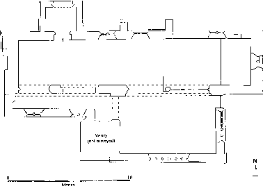
Fig. 18. St. Bartholomew's church, Whittington
The chapel, which before the restoration was divided from the chancel and east end of the nave by a wall containing two square-headed openings of unequal width, (fn. 387) was built by the Cottons and was used by them as a mortuary chapel by 1612. (fn. 388) It has large south and east windows of six and four lights respectively and an east doorway, all of the late 16th or early 17th century. By the later 18th century the chapel seated the lord of the manor's household from Sandywell Park, near by in Dowdeswell. (fn. 389) A blocked window high up on the west wall may once have lit a gallery.
The restoration of 1872, towards which many local gentry and clergy subscribed, (fn. 390) was to designs by F. S. Waller & Son. The wall dividing the chapel from the chancel and nave was replaced by an arcade of two bays, a rood screen between the chancel and nave was removed, the chancel floor was raised, the west gallery was taken down, and open benches were installed in place of box pews. At the same time all the roofs save those of the porch and chapel were replaced, two external buttresses were built against the nave north wall, and the south vestry was added. (fn. 391)
The font of c. 1200 is plain and sturdy with an octagonal bowl and stem. Of the other fittings, the wooden pulpit and the choir stalls date from 1936. (fn. 392) In the chancel carved 17th-century wooden fragments have been reused as a pair of cupboard doors set into 18th-century panelling said to have been made from pews from Sevenhampton church. (fn. 393)
Three effigies kept in the chapel since 1936 (fn. 394) date from the late 13th century and the early 14th. (fn. 395) Two of the monuments, representing knights bearing the arms of the de Croupes family, (fn. 396) are larger than life-size and were moved in 1872 to the south aisle from the openings leading into the chapel. (fn. 397) The third effigy, of a female, was perhaps that recorded in a niche on the north wall in the early 18th century. (fn. 398) It was at the west end of the aisle in the later 18th century; (fn. 399) a tombchest fragment displaying the de Croupes arms next to it was reset under the window on the chancel south wall in 1894. (fn. 400) The chancel floor contains the remains of brass memorials to Richard Cotton (d. 1555), his wife Margaret (d. 1559), and two children. (fn. 401) Thomas Tracy (d. 1770) of Sandywell, the lord of the manor, is commemorated by the principal wall monument in the chapel. Many wall monuments were moved in 1872, those in the chancel to the rector James Ingram (d. 1670) and his family being placed on the west wall where the doorway had once been. A monument to Giles Watkins (d. 1691), a former curate, was left in place outside on the nave north wall. (fn. 402) The glass in the chancel east window was made in 1901 in memory of Queen Victoria. (fn. 403) That in the the chancel south window was designed the following year to incorporate a medieval figure of St. Peter said to have come from Burford (Oxon.). (fn. 404) The single bell housed in the bellcot in the early 18th century (fn. 405) was presumably that replaced in 1856; (fn. 406) the new bell had apparently been cast the previous year. (fn. 407) A set of plate given by Mary Tracy in 1783 comprised a chalice, two patens, and a flagon; (fn. 408) following its theft from the church in 1985 copies of the original pieces were made. (fn. 409)
The churchyard contains near the chancel the base and shaft of a 14th-century stone cross and a group of five tombchests, the earliest dating from the mid 17th century. Among the graves are those of a few of the residents of Sandywell Park while it was an asylum in the mid 19th century. The parish registers begin in 1539 but there are some gaps in entries. (fn. 410)
Nonconformity.
Wesleyan Methodists from Winchcombe registered a house in Whittington in 1812 (fn. 411) but their mission was evidently abandoned soon afterwards. (fn. 412) In 1841 a cottage rented for use as a place of worship was registered by a Baptist from Charlton Kings. (fn. 413) In the mid 1860s Wesleyan Methodists of the Cheltenham circuit established a meeting in Whittington but from 1867 they centred their mission in the area on Andoversford. (fn. 414)
Education.
In 1818 Whittington had a Sunday school for 40 children. (fn. 415) It remained open in 1825, (fn. 416) when the parish clerk was a teacher, (fn. 417) but £1,000 left by the lady of the manor Rebecca Lightbourne (d. 1823) to establish a Sunday school there (fn. 418) was, as a result of litigation over her will, not paid to the charity's trustees until 1829. (fn. 419) The trustees used the bequest and the accrued interest to found a day school as well as a Sunday school for the parishes in which Mrs. Lightbourne's estates had lain. The schools opened in 1830 in a house in Whittington village and taught boys and girls in separate rooms, one on each floor, the rest of the building being accommodation for the teachers, a married couple. On weekdays the pupils came principally from Whittington, Dowdeswell, and Sevenhampton and most were educated free of charge. A few were from outlying parts of other nearby parishes. On Sundays the Sevenhampton children attended a school held in their own parish with financial support from the charity. (fn. 420) In 1833 the Whittington schools taught 68 children on weekdays and 39 children on Sundays; (fn. 421) in 1847 the numbers were 48 and 72 respectively. (fn. 422) In 1840, after a decline in the number of fee-paying pupils in the day school, the annual fee had been reduced from £1 10s. to 12s. (fn. 423)
In 1860 W. L. Lawrence, the surviving trustee and the owner of the school, conveyed the building to new trustees, who were local clergy, and formed a committee to run the schools as church schools. (fn. 424) The schools' income, from Rebecca Lightbourne's charity, was supplemented from 1861 by the rent of a stable adjoining the school building. The day school received a government grant from 1873. (fn. 425) By that time it taught very few children from outside Whittington and in 1872 the average attendance was 30. (fn. 426) In the later 1860s a porch and a bellcot were added during improvements to the school and later the house was remodelled with the upper floor as the schoolroom, reached by an external staircase. In 1883 a new schoolroom paid for by voluntary contributions was built in the garden to the west; (fn. 427) the schoolroom it replaced remained in use as a classroom and as a meeting place. (fn. 428) The day school continued to be supported by the Lawrence family (fn. 429) and as Whittington Lightbourne Charity school it had an average attendance of 40 in 1904, (fn. 430) 50 in 1910, and 40 in 1922. (fn. 431) It closed in 1929 and the children were transferred to the school opened at Andoversford the previous year. (fn. 432) Under a Scheme of 1930 the income from Rebecca Lightbourne's charity was used to pay the incumbents of Whittington and several nearby parishes £2 a year each for Sunday schools and to make other payments in support of education. The Scheme was amended in 1990 (fn. 433) but the charity was in abeyance in 1998. (fn. 434) At that time the building in which the charity schools had opened in 1830 was two dwellings and the schoolroom of 1883 was Whittington village hall.
Charities for the Poor.
By will proved 1674 Ralph Thayer, a Whittington woollen draper, left £30 for the distribution of clothing, including shoes and stockings, to the poor of the parish at Christmas and Easter. (fn. 435) Distribution of the charity, which had an income of £1 10s., was halted from 1739. On its resumption in 1757 the principal was augmented to £40 with part of the unspent income and was entrusted to lord of the manor, Thomas Tracy, who gave the overseer of the poor £2 a year for distribution at Easter. (fn. 436) The principal, apparently retained by Mary Tracy after her husband's death, (fn. 437) was later held by the rector, who distributed the charity in the 1820s. (fn. 438) The rector Walter Thomas (d. 1799) by will left £50 to be distributed with the Thayer charity, (fn. 439) but the legacy was apparently used to pay his former housekeeper £2 10s. a year until 1819 when his executor maintained that the principal had been exhausted by those payments. The Charity Commissioners later took steps to secure Thomas's bequest. (fn. 440) In 1922 the object of the two charities, which had become uncertain, was confirmed as the provision of clothing and not merely gifts of money (fn. 441) but under a Scheme of 1969 their income was to be distributed either in gifts in kind or in grants of money. (fn. 442) The charities had evidently ceased by 1998. (fn. 443)