A History of the County of Leicester: Volume 4, the City of Leicester. Originally published by Victoria County History, London, 1958.
This free content was digitised by double rekeying. All rights reserved.
'The ancient borough: St. Mary's', in A History of the County of Leicester: Volume 4, the City of Leicester, (London, 1958) pp. 369-380. British History Online https://www.british-history.ac.uk/vch/leics/vol4/pp369-380 [accessed 19 April 2024]
In this section
ST. MARY'S
The parish of St. Mary de Castro consisted (fn. 1) of a small area lying within the ancient borough walls, of the South Fields of Leicester, to the east of the Soar, with certain meadows in the Soar valley attached to them, and of the liberty of Bromkinsthorpe to the west of the Soar. The topography, manorial history, and economic history of Bromkinsthorpe are not closely connected with those of the rest of the parish, and are described separately at the end of the present article.
Within the borough St. Mary's parish occupied the south-west corner of the walled area adjoining the castle, which stood at the south-west angle of the town. The most important street in the parish has always been the thoroughfare joining the North and South gates, and running through the whole area within the walls. This important road, now known as Southgate Street for the southern portion of its length, and as High Cross Street for the rest, was in the Middle Ages known as High Street. (fn. 2) The street is mentioned under that name in 1306, (fn. 3) but had in all probability existed for a considerable period before that date. In the 16th century the name 'High Street' was transferred to another thoroughfare, previously known as the Swinesmarket, (fn. 4) which has retained the name of High Street ever since. The name of Southgate Street was in use by about 1666 for the portion of the former High Street which lay in St. Mary's parish. (fn. 5) Of the other streets in the parish, Red Cross Street, leading off Southgate Street to the south, is first mentioned in 1557, (fn. 6) but the house known, no doubt from its sign, as the Red Cross is referred to in 1493–94, (fn. 7) and the street must have derived its name from this building. The present Castle Street, running from Southgate Street to the West Bridge, was known during the Middle Ages as Soar Lane, (fn. 8) and under that name is first mentioned in 1458. (fn. 9) Perhaps to avoid confusion with the other Soar Lane, which lay outside the borough's north wall, this street was renamed St. Mary's Church Lane at some time before the late 18th century, (fn. 10) but about 1800 it was given its present name of Castle Street. (fn. 11) The present Bakehouse Lane, leading off Southgate Street to the west, is mentioned in 1484 under the name of Fosbrooke Bakehouse Lane. (fn. 12) Possibly the street's name derives from the existence in this part of the borough of several of the common bakehouses, where the town's inhabitants were obliged up to the 16th century to do their baking. (fn. 13) Only one street of any importance, Friar Lane, leads off Southgate Street to the east within St. Mary's parish. Friar Lane, which takes its name from the house of Franciscan friars that stood just outside the parish, is mentioned in 1391. (fn. 14)
During the Middle Ages the main route from London and the south reached Leicester by means of the road from Welford, and entered the borough through the South Gate. So long as this route continued to be important Southgate Street must have been one of the chief roads of the town. In the 17th century, however, the route through the South Gate and along Southgate and High Cross Streets was superseded, for most of the traffic from south to north, by a new route running along the east side of the borough walls. (fn. 15) This development must have much reduced the importance of Southgate Street. About 1815 it was said of the street that 'The buildings in general are tolerable', (fn. 16) but a drawing of the street, made about 1825, shows that it then contained, besides some good buildings in the Regency style, a number of rather dilapidated timbered houses, with upper stories projecting over the roadway. (fn. 17) At the present time (1956) Southgate Street remains a thoroughfare of some importance but its narrowness, and the fact that it leads into the tangle of congested streets that still occupy the area of the old walled borough, prevent it from carrying a really substantial amount of traffic. The part of St. Mary's parish that lies within the area of the old borough walls consisted in 1956 mainly of factories and warehouses, though there were some dwelling houses, mostly built in the Victorian period.
Outside the southern wall of the borough, but within St. Mary's parish, lay the great south field of Leicester, stretching from the line of the Roman Gartree Road (fn. 18) on the east to the meadows bordering the Soar on the west, and from the borough wall (fn. 19) on the north to the boundary of Knighton (fn. 20) on the south. (fn. 21) The total area of the south field itself was about 450 acres; (fn. 22) the meadows along the east bank of the Soar covered perhaps another 150 acres. (fn. 23) The whole area of some 600 acres made up by the open field and the adjacent meadows was commonly known as the South Fields. The land along the Soar formerly occupied by meadows is alluvium. The line of the former boundary between the meadows and the open fields coincides fairly well with the edge of the gravel terrace which borders the river's alluvial flood plain. (fn. 24) The open field lay on the terrace, and on the rather higher region of Marlstone, largely covered with Boulder Clay, which lies to the east of the gravel, and farther away from the river.
The south field is first mentioned in 1282, (fn. 25) but it may well have existed long before that date, as there was a considerable area of agricultural land attached to Leicester in 1086. (fn. 26) In the 14th century the field was divided into wongs, or culture, in which lay arable strips of the usual type. (fn. 27) In addition, it was divided into three open fields, the Gallowtree, Middle, and Rawdyke Fields, by means of which a triennial system of rotation of crops was apparently carried on. (fn. 28) Of the meadows which lay between the south field and the Soar, that called the Cowhay is mentioned in a document of 1191–1204. (fn. 29) The Cowhay lay some distance outside the south gate, bordering on the Soar, to the west; to the east the Cowhay did not extend so far as the Aylestone Road. (fn. 30) Immediately to the south of the Cowhay lay another meadow, mentioned at the same time, the Oxhay, also known as Marymeadow. (fn. 31) The location of a third meadow or pasture, Taskholm, mentioned in the same document, is uncertain, but it seems to have lain to the north of the Cowhay. (fn. 32) Close Meadow and Bedehouse Meadow (fn. 33) lay on a large island formed by two branches of the Soar. Close Meadow is mentioned in 1433, (fn. 34) and Bedehouse Meadow in 1546. (fn. 35)
By the late 12th century the greater part of the South Fields, both meadow and arable, seems to have belonged to the earls of Leicester, and it is likely that their extensive property in this area was originally acquired by Robert de Beaumont, probably the first earl, early in the century when he gained extensive possessions in Leicester that had previously belonged to the king and to the Grentemesnil family. (fn. 36)
Earl Robert FitzParnell, at some date between 1191 and 1204, granted the Cowhay to the burgesses of Leicester, subject to a payment to the earl of 3d. a year for every beast pastured there. (fn. 37) The earl was in possession of the Oxhay when this grant was made. (fn. 38) Earl Robert's grant was confirmed by his successor, Simon de Montfort. (fn. 39) When the Hospital of St. Mary in the Newarke was founded by Henry, Earl of Lancaster and Leicester, in 1330 the endowment provided by the earl included 4 carucates at Leicester, (fn. 40) and these were evidently in the south field. (fn. 41) The hospital (later the College of the Newarke) also acquired, apparently as appurtenances to their 4 carucates in the south field, the Oxhay, Close Meadow, a close called Gosling Croft, and the right to the payment of 3d. a year from each beast pastured in the Cowhay. (fn. 42) Further small quantities of arable and meadow, acquired by the college in 1368, 1373, 1392, 1405, and 1424, probably lay in the South Fields also. (fn. 43) The Newarke College thus became by far the largest landowner in the South Fields.
At an early date buildings and small inclosures began to spread southwards from the borough wall. Buildings outside the South Gate are mentioned in 1273. (fn. 44) Millstone Lane, which ran just outside the south wall of the borough, is mentioned in 1452, (fn. 45) and by 1484 the houses outside the South Gate were sufficiently numerous to form one of the twelve wards into which the borough was then divided. (fn. 46) St. Sepulchre's chapel, (fn. 47) which stood some distance outside the south gate, (fn. 48) and which was in existence by 1204, (fn. 49) presumably served the suburb outside the walls. The main road from the South Gate to Welford, and beyond it to London, was known as Peatling Gate, or Peatling Way, (fn. 50) in the late 13th and early 14th centuries, (fn. 51) but the section lying immediately outside the walls was known as South Gate in the 16th and 17th centuries. (fn. 52) By 1610 there were houses along both sides of the road for some distance outside the borough's South Gate. (fn. 53) When Leicester was fortified by the Parliamentarians against Charles I some houses outside the South Gate were demolished, and an earthwork was thrown up to protect the town. (fn. 54) In 1647–8, after the danger from the Royalists was considered to be over, the earthwork was levelled at the corporation's expense. (fn. 55)
When the Newarke College was dissolved under Edward VI its extensive property in the South Fields, forming a large farm generally known as the Newarke Grange, fell into the hands of the Crown, which first leased the farm to Leicester Corporation and others, and then in 1613 sold all the property to the corporation. (fn. 56) The arable thus acquired by the corporation in the south field amounted to 16 yardlands, (fn. 57) and there was in addition all the meadow land which had belonged to the Newarke College. (fn. 58) The corporation's arable holdings in the south field were enlarged by the purchase of two further yardlands from a Mr. Wightman, in or shortly before 1589, (fn. 59) the acquisition of two more yardlands from Richard and Francis Archer about 1602, (fn. 60) and the purchase of some further arable, apparently half a yardland, from Robert, Lord Spencer, in or just before 1622. (fn. 61) With these minor purchases added to the Newarke Grange, Leicester Corporation became the only important landowner in the South Fields.
Although much the greater part of the south field was thus in the hands of a single owner, the arable continued until well into the 18th century to be divided into arable strips, and it was let by the corporation in farms made up of one or more yardlands each. (fn. 62) The inclosure of the south field was delayed because of the rights which the borough freemen possessed to pasture livestock there. The grant of the Cowhay to the Leicester burgesses for pasture has already been described. It is possible that the burgesses had once enjoyed pasture rights over all the meadows in the South Fields, and that those rights had been curtailed in the 12th century by the earls of Leicester, for in 1433 the mayor, burgesses, and community of Leicester claimed that they were entitled to common of pasture for their stock in Close Meadow and Gosling Croft; the College of the Newarke, to which the two fields belonged, denied this, and the arbitrators to whom the matter was submitted ruled in favour of the college. (fn. 63) The right to pasture stock in the Cowhay was limited to freemen of the borough, (fn. 64) and it does not seem that any others were strictly speaking allowed pasture rights there. (fn. 65) About 1648 the corporation decided to use the Cowhay as a horse pasture, and to make use of a meadow called Burgess Meadow (fn. 66) as the cow pasture, but this seems to have been only a temporary arrangement. (fn. 67) Besides pasture rights in the Cowhay, the free burgesses of Leicester enjoyed rights of common for their livestock on the arable of the south field. These common rights are mentioned in 1605, (fn. 68) but no doubt had been in existence from a much earlier period. The freemen's rights of common in the arable of course only allowed them to pasture their livestock there while crops were not actually growing; about 1675 it was stated that by ancient custom the freemen's pasture rights began at Michaelmas, and lasted until Lady Day. (fn. 69) In the 17th century a serious conflict of interests arose between the farmers who rented the arable from the corporation, and the freemen of the town. About 1675 some freemen petitioned the corporation, saying that the farmers were harming the freemen's common rights by putting sheep into the fields before Michaelmas, contrary to custom, by putting more beasts into the fields to pasture than was usual, by hindering freemen from putting their animals in for pasture, and by damaging the pasture land in various ways. It was also complained that the farmers were failing to keep an adequate bull and boar, as they were by custom obliged to do. (fn. 70) These grievances were probably long-standing, as in 1605 the corporation had felt obliged to restrict the numbers of sheep that the farmers put into the south, (fn. 71) and about 1624 some inhabitants of Leicester petitioned the corporation, asking for the area available for pasture to be enlarged. (fn. 72) In the 18th century the freemen's rights in the South Fields became an important issue. The long, and at times violent, struggle brought about between the corporation and the freemen by the corporation's desire to inclose the fields has been described elsewhere. (fn. 73) Here it may be remarked that in the 1750's the corporation succeeded in dividing the arable of the south field into a small number of large farms, which were fenced, but that despite this degree of inclosure the freemen retained their rights of pasture over the arable area until 1804. (fn. 74)
One result of the freemen's continued enjoyment of pasture rights in this area was that the South Fields were not available for building purposes, and during the 18th century the urban area of Leicester expanded on the south very little. A map of Leicester drawn in 1792 shows houses stretching along the main road to Welford, the present Oxford Street, for some distance to the south of the site of the old South Gate, (fn. 75) with some further buildings along Millstone Lane, just outside the old walled borough, and along Hangman Lane nearby. (fn. 76) In 1785 a treelined promenade, later known as the New Walk, was laid out along the western boundary of the South Fields, following the line of the Roman road, (fn. 77) but no building was done along it until the 19th century. In 1767 Chapel Close on the main road to Welford was purchased as the site for the infirmary, but this seems to have been the only serious encroachment on the South Fields during the 18th century.
The site of Leicester Infirmary is the triangle formed by Infirmary Road and New Bridge and Knighton Streets. In 1766 Dr. William Watts of Medbourne, who afterwards lived at Danet's Hall, made frequent appeals in the Leicester Journal for the establishment of such an institution. A subscription fund was set up, Chapel Close was acquired, and in September 1768 the plans for the building were approved. (fn. 78) The architect was not James Wyatt, as has frequently been stated, but his father, Benjamin Wyatt of Weeford (Staffs.), who designed the infirmary at Stafford about the same date. (fn. 79) The building was completed in 1771. (fn. 80) A lunatic asylum by William Harrison was added in 1781 and extended to designs by William Firmadge in 1794. The fever ward by William Kirk was built in 1818 (fn. 81) and numerous additions were made throughout the 19th century and the first fifty years of the 20th century. The original structure is so set about with modern buildings that it is hardly visible. It is of three stories, with a central bow-fronted block jutting forward between two side wings. It is of red brick with stone dressings.
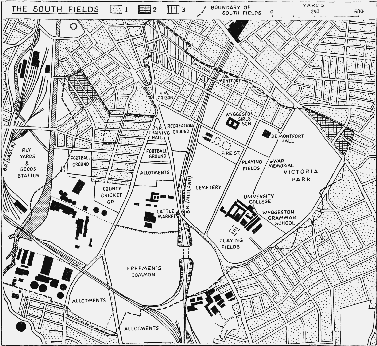
The South Fields
1. Land built up in 1950.
2. Parts of the South Fields privately owned after inclosure.
3. Land sold by the corporation and built over by 1828.
The South Fields were inclosed under an Act of 1804, (fn. 82) by which the conflicting interests of the corporation and the freemen were dealt with in a manner satisfactory to both parties. The award (fn. 83) made under this Act gives the total area of arable as 490 acres, and the area of the Burgess Meadows, (fn. 84) as the meadows in the South Fields were then named, as 116 acres. One hundred and twenty-five acres were allotted by the award to the freemen in full satisfaction of their pasture rights, 14 acres were allotted to various minor landowners, 453 acres, free of all common rights, were allotted to the corporation, and about 12 acres were sold to defray the expenses of the inclosure. The land handed over to the freemen was to be managed by deputies elected by the freemen of the borough parishes. The freemen's land lay in three parcels, one of rather more than 36 acres, lying between the Soar on the west and Aylestone Road on the east, a second lying on the east side of Aylestone Road, and extending to Welford Road on the east and to the borough boundary on the south, totalling 85 acres, (fn. 85) and a small plot of just over 2 acres on Saffron Lane. (fn. 86)
The inclosure of the South Fields made available for building a large district close to the rapidly growing borough, and it is not surprising that houses soon began to encroach upon the agricultural land. Part of the land sold to meet the cost of inclosure lay on the New Walk, and was sold in small plots suitable for building. (fn. 87) The handsome houses in the Regency style which still occupy much of the northern part of the New Walk were erected during the few years immediately after the inclosure award was issued in 1811. (fn. 88) The corporation, which had already developed for building its property in the part of St. Margaret's parish adjacent to the South Fields, (fn. 89) soon began to sell off for building its own land, which comprised the portion of the South Fields nearest to the town. (fn. 90) By 1828 a considerable amount of building had been done in the north-east part of the South Fields, and many new streets, still without houses at that time, had been laid out on a rectangular plan. (fn. 91) The Regency houses in the New Walk were joined by other houses in the same style, of which the most notable survivors are the Crescent, built in King Street about 1820, and Crescent Cottages, built in the same street in 1836. (fn. 92) A new county gaol, which provoked William Cobbett to make some strongly worded comments when he visited Leicester in 1830, was built in 1825–9 on land beside the Welford Road bought from the corporation. The architect was William Parsons and the building, which is surrounded by high brick walls with massive corner buttresses, cost over £20,000. (fn. 93) The Leicestershire and Rutland Lunatic Asylum was completed in 1837 from plans made by William Parsons from models shown to the asylum committee in 1835 by a Mr. Wallett, superintendent of the Dorset County Asylum. (fn. 94) The site, at the top of Knighton Hill overlooking the town, was purchased from the corporation. The original block is a large and well-designed rectangular building in gault brick. The front elevation has four projecting wings, each with three windows, the recessed blocks between having eight windows at each side and seven in the central block in which is a projecting doorway under a pediment. Additions to the original design, in the form of long side wings in red brick, were made shortly after the opening of the asylum, and the building remained in use until the erection of the new asylum at Narborough in 1907. During the First World War it was used as a military hospital and in 1918 was purchased by T. Fielding Johnson and presented to the University College of Leicester, which was opened in 1921. Since 1945 the rapid expansion of the college has enabled many additions to be made. These include the south wing extension (1948–50), the library extension (1953) and the Astley Clarke Laboratories (1951). In 1954 the Percy Gee Building, which is to house refectories, common rooms, and the Students' Union, was begun. (fn. 95)
University College, Leicester. Gules, an open book strapped proper and buckled and inscribed with the words 'Ut Vitam Habeant' in letters or between in chief two cinquefoils pierced ermine and in base a horseshoe also or. [Granted 1922]
The development of the South Fields as a residential district was cut short, in the first instance apparently by the building of the Midland Railway's line through the area in 1840. (fn. 96) The railway's proximity made the South Fields less attractive to the more wealthy of Leicester's inhabitants, whose villas were beginning to spread out on the southern outskirts of the town. As a result those parts of the South Fields which were not already built on by 1840, that is the whole area except the north and a zone bordering the New Walk on the east, were used either for housing of a working class character, or for various public purposes. The north-west part (fn. 97) of the South Fields was built up, mostly in 1850–65, with streets of red brick terrace houses, (fn. 98) which in 1956 still remained. In 1877 the corporation decided to set aside 18½ acres to the south of these streets as a site for gas works, (fn. 99) which were built in the following year. (fn. 100) Subsequently they were much extended and electricity plant was added. (fn. 101) In 1920 some contiguous land, belonging to the Leicester freemen, and lying between the Soar and Aylestone Road, was purchased by the corporation as a site for an electricity generating station. (fn. 102) Of the remaining land in the South Fields, the Leicester freemen still possess nearly all the 85 acres allotted to them between Aylestone Road and Welford Road at the inclosure. (fn. 103) The small plot of some 2 acres owned by the freemen on Saffron Lane was sold to Leicester Corporation in 1924. (fn. 104) The corporation's property, which remained very extensive despite sales of building land in the years after the inclosure, (fn. 105) was gradually made use of for various public purposes. Fourteen acres on the Welford Road, near the southern boundary of St. Mary's parish, were sold to the county authorities in 1835 as the site for a lunatic asylum. (fn. 106) Other land in the same area was used for a municipal cemetery, opened in 1849, (fn. 107) for a livestock market, opened in 1872, (fn. 108) and for a fire station, opened in 1927. (fn. 109) An area of about 70 acres in the south-east corner of the South Fields, after having been used as a racecourse from 1806 onwards, (fn. 110) was in 1884 laid out as a public park. (fn. 111) The Bedehouse Meadows, where the Leicester burgesses had not enjoyed common rights, were sold by the corporation in 1896 to the Manchester, Sheffield, and Lincolnshire Railway, (fn. 112) and have since been used for marshalling yards. The large island between two streams of the Soar, where the Bedehouse Meadows lay, was considerably altered in shape by the corporation's flood-prevention works, carried out in 1868–90. (fn. 113) The consequence of the failure to develop the South Fields as a residential district was the creation well inside the modern urban area of Leicester of a region still (in 1956) largely open.
Parish Administration.
That part of St. Mary's parish which lay within the town walls was always part of the borough, but the right of the borough authorities to exercise jurisdiction in the South Fields and Bromkinsthorpe was for long a subject of dispute. During the Middle Ages Bromkinsthorpe was certainly considered to lie within the borough. (fn. 114) There does not appear to be any evidence to show whether the South Fields were under the control of the borough or not. By the end of the 16th century the borough's rights of jurisdiction in the parts of the parish that were outside the walls were evidently felt to be insecure, for the charter which the corporation obtained from Elizabeth I in 1599 provided that the whole of St. Mary's parish should be under the jurisdiction of the borough. The charter, however, made this provision subject to the reservation that rights already granted to others should be preserved, and consequently the borough's rights in the South Fields and Bromkinsthorpe were not indisputable. (fn. 115) During the 18th and early 19th centuries a prolonged conflict took place between the borough and the county justices over the right to levy rates and exercise jurisdiction in the two areas. The course of the quarrel has been dealt with elsewhere. (fn. 116) The final result, only attained, after much litigation, in 1815, was that the borough and county justices exercised concurrent jurisdiction in Bromkinsthorpe and the South Fields, while the county had an exclusive right to levy rates in both areas. (fn. 117) The only parts of St. Mary's parish that remained wholly under the control of the borough were the portion lying within the old walled area, and a small district lying immediately outside the walls, and bordering on the South Fields. (fn. 118) The South Fields and Bromkinsthorpe were brought within the borough for Parliamentary purposes under the Boundaries Act of 1832, (fn. 119) and for municipal purposes under the Municipal Corporations Reform Act of 1835. (fn. 120) St. Mary's remained a civil parish within the borough until 1896, when the whole of Leicester was formed into a separate civil parish. (fn. 121)
The most notable feature of the internal administration of St. Mary's parish was the establishment of a close vestry. (fn. 122) In 1577 it was decided at a parish meeting to set up a committee of thirteen leading parishioners, to take charge of parish affairs. (fn. 123) The body thus set up, generally known as the vestry, (fn. 124) conducted all the affairs of the parish, levying rates, (fn. 125) electing the churchwardens, the overseers of the poor and of the highways, (fn. 126) the parish clerk, (fn. 127) and the sexton, (fn. 128) and closely controlling expenditure. (fn. 129) The thirteen vestrymen appear normally to have remained in office for life, though this is nowhere explicitly stated. Vacancies were filled by co-option. (fn. 130) In 1657 the vestry made it a rule that no matters which were in dispute within the vestry were to be divulged to outsiders. (fn. 131) The Ruding family, who were for long lords of the manor of Westcotes within the parish, usually supplied one member to the vestry. (fn. 132) Such close vestries were of course established in many other English parishes. (fn. 133) The parish adopted the Sturges Bourne Vestry Act of 1819. (fn. 134) The administration of the poor law in St. Mary's has been dealt with elsewhere. (fn. 135)
Churches.
A college of secular canons was established in the church of St. Mary de Castro by Robert de Beaumont, Count of Meulan and probably the first Earl of Leicester; the date of foundation is said to have been 1107. It is possible that a collegiate church had existed before the Conquest. (fn. 136) The history of the college has been described in an earlier volume. (fn. 137) The church, although collegiate, remained also parochial. An ordinance made in the middle of the 12th century by the abbot and canons of Leicester Abbey, to whom the college had been made subordinate in or shortly after 1143, (fn. 138) provided that the church services were to be duly maintained, and that one of the college's clergy was to be a chaplain, whose function was presumably to conduct the normal parochial services. (fn. 139) About 1220 the church was described as appropriated to Leicester Abbey. (fn. 140) From 1238 at the latest it was the practice to institute a vicar for St. Mary's. The vicarage was said in 1238 to be worth at least 6 marks, including 2 marks from Leicester Abbey. (fn. 141) The vicar was appointed by the Abbot of Leicester. (fn. 142) In 1535 the vicar was receiving £8 a year from the abbey. (fn. 143)
Under the Chantry Act of Edward VI the College of St. Mary de Castro was dissolved. (fn. 144) Its possessions fell to the Crown, and were granted by Queen Elizabeth I in 1589 to Leicester Corporation. (fn. 145) The college's property had included the small tithes of the parish, together with all offerings, and the revenue from the churchyard, (fn. 146) all of which thus passed first to the Crown, and subsequently to the corporation. As the great tithes had come into the hands of Leicester Abbey, and had at the Dissolution also passed to the Crown, (fn. 147) hardly any of the normal items of an incumbent's revenue were available in the parish. In 1548, shortly after the college had been dissolved, Ralph Cowley, the last dean of the college, was appointed vicar by the royal commissioners charged with arranging for the continuance of schools, charities, and clergy previously maintained from the revenues of institutions dissolved under the Chantry Act. The commissioners provided that Cowley was to have a stipend of £13 6s. 8d. (fn. 148) It would appear, however, that the only income received by the vicar was the £8 which had been once paid by Leicester Abbey, and which after the abbey's dissolution continued to be paid out of the abbey lands. (fn. 149) About 1580 the parishioners drew up a petition, which stated that owing to the small stipend the parish had been for some time served by unlearned ministers, and asked that the Crown should lease the property of the dissolved college either to the parish, or to the borough corporation, so that the stipend might be augmented from the property. (fn. 150) The petition was unsuccessful, but in 1603 the corporation, which had obtained the college's property, granted to the vicar the Easter offerings, the mortuaries, and certain small tithes, to hold during pleasure in return for some small payments. (fn. 151) Subsequently, from 1643 onwards, the corporation made a yearly grant of £10 to the vicar. (fn. 152) In 1679 Anne Lacy settled, for a payment of £20, a house in the Newarke on the vicar and parish for use as a vicarage, and the corporation made a grant of £5 towards this. (fn. 153) The house in the Newarke fell into decay, and a new vicarage was built in 1934. (fn. 154)
Leicester Corporation presented to St. Mary's in 1602 and 1603, (fn. 155) perhaps as the owners of the college property. In 1618 the Crown presented, (fn. 156) and the Crown remained the patron until the advowson was transferred to the Bishop of Peterborough, whose diocese included Leicester, in 1867. (fn. 157) After the establishment of the see of Leicester in 1926 the Bishop of Leicester became the patron. (fn. 158)
From the early 13th century onwards the church of St. Sepulchre, in the South Fields, was a chapel dependent on the church of St. Mary, although it is uncertain how this situation arose. Hugh de Grentemesnil granted the church of St. Sepulchre to the Norman monastery of St. Evroul (fn. 159) and the grant was confirmed about 1200 by Robert, Earl of Leicester. (fn. 160) By 1220 the church had passed to the college of St. Mary de Castro and was served by a chaplain from there. (fn. 161) It was apparently not a parish church. (fn. 162) It stood outside the South Gate of the borough and was said to be the place where those hanged on the nearby public gallows were interred. (fn. 163) During the 16th century the name St. James's seems to have been applied to the church as often as the name St. Sepulchre's. In 1510 the chancel was in need of repair (fn. 164) and the church seems to have been allowed to decay during the rest of the 16th century. At some point during that time it passed into the possession of the corporation and figures in the chamberlains' accounts of 1606–7, when it was leased to Nathaniel Sampson for 26s. 8d. yearly, with an additional 12d. for the tithe of the churchyard, which was paid to St. Mary's. (fn. 165) By 1634 the building may have disappeared altogether, (fn. 166) except for a few fragments of wall which were still standing in the lifetime of persons living at the beginning of the 18th century. (fn. 167) The last reference to the church seems to occur in 1663–4, when the corporation paid for paving done near to it. (fn. 168) The site of the church can probably be correctly identified as that of the first infirmary buildings, which were built upon Chapel Close, purchased from the corporation. (fn. 169) The suggestion, made by Nichols and others, (fn. 170) that St. James's Church may be identified with the Hermitage which stood in the same area, does not seem to be tenable. Stukeley's map shows the Hermitage quite clearly as standing on the opposite side of the road from the site of the church (fn. 171) and the two are distinguished in the corporation records in the 17th century. (fn. 172)
The two small extra-parochial areas of Castle View and the Newarke were annexed to St. Mary's for ecclesiastical purposes in 1871 by Order in Council. (fn. 173) The growth of the parish's population during the 19th century made necessary the establishment of several new churches. The first of these was that of Holy Trinity, built in 1838 to serve the population of the New Walk and the adjacent streets. The church was built at the cost of Thomas Frewen of Cold Overton, who also provided an endowment. Holy Trinity was originally a perpetual curacy, with Frewen as patron. The advowson remained in the hands of the Frewen family until about 1885 when it passed to the Peache Trustees, who still retained it in 1956. A separate parish was assigned to the church in 1861, and this parish was enlarged in 1886. (fn. 174) The architect of the church was Sidney Smirke, (fn. 175) but his work has suffered much alteration; in 1855 the church was enlarged by Flint & Wickes of Leicester, in 1871 it was extensively altered so as to give the exterior a Gothic appearance by S. S. Teulon, (fn. 176) and in 1872 the spire was added. (fn. 177) St. Andrew's Church, on Jarrom Street in the western part of the South Fields, was begun in 1860, and consecrated two years later. (fn. 178) The architect was Sir George Gilbert Scott. (fn. 179) The building is of brick, in the Early English style, with an ingenious timber roof. St. Andrew's parish was formed in 1862. (fn. 180) The advowson at first belonged to the Bishop of Peterborough, but was transferred to the Bishop of Leicester after the see of Leicester was established. (fn. 181) St. Paul's Church, in the northern part of Bromkinsthorpe, was consecrated in 1871. (fn. 182) It is a Gothic building of Enderby syenite, designed by F. W. Ordish and J. C. Traylen of Leicester. According to the original plan the church was to have included a massive tower and spire, but these were never completed. (fn. 183) St. Paul's parish was created in 1872. (fn. 184) The advowson was originally in the hands of the Bishop of Peterborough, but like the advowson of St. Andrew's was later transferred to the Bishop of Leicester. (fn. 185) In 1890 the church of the Martyrs, on Narborough Road in Bromkinsthorpe, was built by the Revd. Joseph Harris, and the parish was formed in the same year. (fn. 186) The red brick church was designed by Ewan Christian. (fn. 187) The advowson was at first in the hands of the trustees of Joseph Harris and his brothers. (fn. 188) Subsequently, about 1920, the advowson was held by the Bishop of Peterborough and the Principal of Ridley Hall, Oxford, who presented alternately. (fn. 189) After the establishment of the diocese of Leicester in 1926 the Bishop of Leicester replaced the Bishop of Peterborough, (fn. 190) and the advowson was in 1954 shared by the Bishop of Leicester and the Principal of Ridley Hall. (fn. 191) All Soul's Church in Aylestone Road, in the western part of the South Fields, was built in 1907, and was one of the last works of the architect G. F. Bodley. The parish was formed in the same year. (fn. 192) The advowson at first belonged to the Bishop of Peterborough, but after the creation of the diocese of Leicester in 1926 the Bishop of Leicester became patron. (fn. 193) The church of the Holy Apostles on Fosse Road, in Bromkinsthorpe, was built in 1906 to serve an ecclesiastical district created two years earlier. The original church, a temporary iron structure, was replaced by a permanent building by Pick, Everard & Keay in 1924, when the parish was created. The advowson, at first for a short time held jointly by the Bishop of Peterborough and the Principal of Ridley Hall, Oxford, came to the Leicester Diocesan Trustees, who in 1956 still remained the patrons. (fn. 194) In 1914 St. Anne's Church was built just inside the western boundary of Bromkinsthorpe to serve a newly created conventional district. In 1934 a permanent church was built to replace the original temporary one, and the parish was set up. The Bishop of Leicester has been from the first, and in 1956 still remained, the patron. (fn. 195)
The ancient parish church of ST. MARY DE CASTRO (fn. 196) consists of nave, north and south aisles, chancel, tower, north chapel and vestry and south porch. The oldest surviving parts of the church date from shortly after the refoundation of 1107, when a church was begun which was probably completed before 1143. It was perhaps cruciform, but no part of the centre remains. It had a long, aisleless nave and a square-ended chancel terminating 20 feet short of the present east end. Around the lowest stage of the nave ran an internal arcade of round-headed arches carried on columns with reeded capitals. This arcade remains on the west wall and at the west ends of the side walls. The second stage contained roundheaded windows, with polychrome decoration of dark and light stone. On the outside of the church this stage was arcaded, with a window in every fourth arch, but this only survives at the west end of the south wall. There were also round-headed windows in the chancel, on both exterior walls of which are traces of the outside decoration: the windows were linked by blind arches filled with diaper work. The door in the north wall of the chancel also dates from this period.
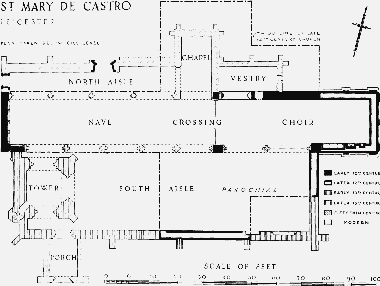
St. Mary de Castro
In the last part of the 12th century, probably about 1160–80, the chancel was extended to its present length and two chapels in echelon were opened out of each transept. New windows were set in the chancel at a higher level, with chevron ornament on their external hoods. Most of this work that still exists is, however, a modern copy of the original. The sills of the three western windows of the chancel are set at a higher level in order to clear the roofs of the transeptal chapels, and the westernmost bay of all had no windows, as the canons' stalls were there. The sedilia in the chancel date from this time, as do the doors in the north and west walls of the north aisle, although these have been reset in their present positions. The nave was by then parochial. On the outside of the south aisle can be seen a short stretch of rough rubble masonry which marks the south wall of the south transept.
Early in the 13th century a large rectangular chapel was built to the east of the south transept, in place of the former chapels in echelon and extending the full width of the transept. The sedilia in this part of the aisle are of this date. At the same time a small south aisle was added to the nave giving access to this new chapel. The lean-to roof of this aisle would have blocked the 12th-century windows, so a clerestory was added. The new chapel was probably parochial, and it looks as though the canons' choir had begun to encroach upon the nave, as the arches which were then cut through the walls of the chancel at the west imply that their stalls had been moved. In the second half of the 13th century the south chapel was extended westwards and a tower built in its west end, supported within the church itself on heavy freestanding pillars. (fn. 197) The large windows in the south aisle were inserted at the same time. The existing arches between south aisle and chancel were made in the 15th century.
There is little or no evidence for the north aisle until the 19th century, when it was rebuilt by Sir George Gilbert Scott, only partly, it seems, on the original plan. The north chapel is dedicated to St. Anne. It was built in 1861 by Scott for the Noble family, the owners of Danet's Hall. (fn. 198) A Danet's Chapel is mentioned in 1638 and there may have been a private chapel for the lords of the manor of Danet's Hall from a much earlier date. The south porch was built in 1860 (fn. 199) (fn. 200) and the vestry in 1904. (fn. 201)
The church has been much restored and altered. The south nave arcade was inserted, during alterations carried out after 1850 under the direction of Sir George Gilbert Scott, (fn. 202) to replace a large brick arch which had carried the east portion of the clerestory since 1780. (fn. 203) About the middle of the 19th century also the north arcade and clerestory were rebuilt, the tracery in all the windows was renewed, the south porch added, and roof largely repaired. Most of the outer walls have been repaired, and further alterations were carried out in 1930 and the years following. (fn. 204)
The spire, which has undergone much reconstruction, was added to the tower at an unknown period. In 1685 five yards of the spire had to be taken down. Further extensive repairs were necessary in 1757 and 1763, and in 1783 the spire had to be entirely rebuilt. Further repairs had to be carried out in 1871 and 1916. (fn. 205)
Beneath the tower stands the mid-13th-century font; it has a bowl-shaped basin on a circular stem, and is decorated with a trefoiled arcade of four arches, with carved heads between. (fn. 206) In the nave is a panelled oak chest, finely carved, dating from the 17th century. A number of 14th-century tiles in the floor of the tower include two bearing alphabets. The mayor's pew, made in 1491, formerly stood against the north wall of the chancel. It was removed in 1845, but a list of the borough's mayors marks the spot where the pew formerly stood. (fn. 207)
Leicester Corporation, after it had acquired the property of St. Mary's College, was responsible for the upkeep of the chancel. In 1610 the borough chamberlains note the payment of 14d. in fees when the corporation was summoned to the court of the bishop's commissary to show why the chancel had not been repaired. (fn. 208) Similar summonses were answered in 1626 and 1632. (fn. 209) In the latter year the chamberlains' accounts contain details of repairs to the chancel windows, (fn. 210) but in 1638 the archdeacon ordered that the chancel should be repaired, especially the east window, which had been stopped up with mortar and stones. (fn. 211) In 1797 it was ordered that provision should be made for draining the churchyard so that the foundations of the building might be safe from harm by subsidence, and that the church should in future be kept cleaner. (fn. 212) In 1832 Archdeacon Bonney noted that the corporation was responsible for what he called the north aisle, (fn. 213) by which he apparently meant the chancel; this confirms a statement made at the visitation of 1775 that the old chancel was never used, though kept in repair by the corporation. (fn. 214) By 1832 the great south aisle had by custom become the nave, and it remained so until the chancel and old nave were restored later in the 19th century. (fn. 215)
The registers date from 1600. The earliest existing pieces of plate are two silver cups and two patens, all dated 1688, and a silver dish, dated 1687. There are also two silver flagons, both of 1722. Much earlier church plate has been lost. (fn. 216) The church has eight bells. The oldest bears the date of 1631, and the other seven were all cast by T. Mears of London in 1830.
The tithes of St. Mary's parish belonged to Leicester Abbey, except that the Norman abbey of St. Evroul received one-third of the tithes of 3 carucates. (fn. 217) Leicester Abbey's possession of most of the parish's tithes was no doubt based on the grant to it, when founded in 1143, of all the possessions of the older college of St. Mary. (fn. 218) Robert FitzParnell, Earl of Leicester 1190–1204, confirmed to St. Evroul the tithes of all his demesne lands at Leicester; (fn. 219) it is probable that the tithes had originally been granted to St. Evroul by Hugh de Grentemesnil, the owner under William I and William II of much land at Leicester that later came to the earls of Leicester, and one of the joint founders of St. Evroul. (fn. 220) At some unknown date the abbey of St. Evroul demised its tithes at Leicester at perpetual farm to Leicester Abbey, (fn. 221) and after 1415 when St. Evroul's English possessions were transferred to Sheen Priory (fn. 222) Leicester continued to farm the tithes from Sheen. (fn. 223) In a document drawn up between 1152 and 1167 the Abbot and Convent of Leicester allocated most of the tithes of the parish to the canons of the College of St. Mary de Castro, (fn. 224) who were still receiving them in 1535. (fn. 225) After the Dissolution the small tithes of the parish were possessed by Leicester Corporation. The corporation was receiving the small tithes by 1603–4, (fn. 226) but does not ever seem to have obtained a grant of them; at times the lack of any sound title to the small tithes caused the corporation some anxiety. (fn. 227) Apparently it had assumed that it had the right to the tithes as part of the property of St. Mary's College, though the charter of Elizabeth I, which granted the college's possessions to the corporation, does not mention tithes at all. (fn. 228) The great tithes of Westcotes were sold by the Crown, which had acquired them at the Dissolution, to Edmund Downinge and Peter Ashton in 1582. (fn. 229) The Westcotes great tithes changed hands repeatedly until in 1652 they were sold to Walter Ruding, the lord of the manor, and his son, Walter Ruding the younger. (fn. 230) From 1652 the great tithes remained in the hands of the Ruding family, and of the subsequent owners of Westcotes, until commuted. (fn. 231) The great tithes of nearly all the remaining land in Bromkinsthorpe also came into the possession of the owners of the land there. (fn. 232) The great tithes of the South Fields were bought by the corporation in 1754, (fn. 233) and when the South Fields were inclosed in 1804, all tithes there were extinguished, the corporation being allotted land in compensation. (fn. 234) The tithes of Bromkinsthorpe were commuted in 1849; the corporation received £79 7s. 9d. a year as owners of the small tithes and the landowners received £161 16s. 4d. as the owners of most of the great tithes; small sums were allotted to Clement Winstanley of Braunstone, to the devisees of Thomas Pares, and to the trustees of Wyggeston's Hospital for their rights in respect of the great tithes. (fn. 235)
Charities.
Most of the charities of St. Mary's have been lost. In 1786 the parish was receiving 10s. a year from a house in the Market Place. The donor was said to be a Mr. Watts, but nothing further is known about this gift. The sum had increased to 16s. by 1837, (fn. 236) but no return for the charity was made in 1862–3 (fn. 237) and it has ceased to exist. It is possible that the payment derived from the gift made in or before 1649 by Julius Billers, who gave or bequeathed £10 to the poor of the parish. The corporation of Leicester seems to have been responsible for the charity, for the £10 was paid over to it in 1648–9 and in 1649 it was decided that 10s. should be distributed annually from the town's chamber until the £10 should be laid out in the purchase of land. (fn. 238) The payment of 10s. is recorded in the chamberlains' accounts in 1650–1, (fn. 239) but nothing further is known of this donation.
John Nurse by will dated 1624 left 13s. 4d. to the parish to be paid out of a close in Sanvey Gate. The payment was in arrears in 1837 and has not been recovered. (fn. 240) Joseph Wright's Charity of 13s. 4d. a year, probably paid out of a house in Belgrave Gate, was established before 1786 and lost before 1837. (fn. 241) William Ruding left £50 in 1748, the interest of which was to be laid out in coal for the poor of St. Mary's. The interest had not been paid for many years before 1837 and has not been revived. (fn. 242) John and Ann Lacy by deed dated 1765 granted to trustees a new house in Grange Lane, off Oxford Street, the rent from which was to be given to five poor widows. In 1837 the house was in bad condition and the rent was being given to more than five persons. (fn. 243) By 1862–3 the house was ruined and no rent was paid. (fn. 244) In 1716 Lucy Fownes left £20 for the use of the poor in the parish. The money was used for the repair of the workhouse and for some years before 1837 no interest from the £20 was distributed to the poor. In 1837 it was held that the workhouse must be considered as charged with the £20. (fn. 245) This charity still existed in 1862–3, when it was known as the Fownes or Clarke Charity and consisted of 11s. 6d. interest from £20 held in the Savings Bank, which was distributed to the poor. (fn. 246) This charity also has ceased to exist.
Shortly before 1687 Mrs. Anne Lacey apparently left £10 in trust with the corporation, which distributed the interest of 12s. to the poor of St. Mary's parish. A Mr. Sharman, probably William Sharman, gave £10 or £11 to the corporation before 1677–8, the interest of which was to be paid to the poor of the parish. These two charities had lapsed before 1837, but it was then held that they should be revived, there being no evidence that the principal sums had ever been returned to the parish. (fn. 247) No return was made for these charities in 1862–3 but they were still paid in 1955, and then produced about £7 a year, which was distributed in the form of bread tickets to the poor of the parish. (fn. 248)
St. Mary's parish receives 2s. from the Hobbie Charity, £1 1s. 4d. from the Courteen Charity, and £1 from William Ive's charity; all these payments are made by the corporation. A payment is made by the Leicester General Charities from the Heyrick Bread Charity. (fn. 249)