A History of the County of Leicester: Volume 4, the City of Leicester. Originally published by Victoria County History, London, 1958.
This free content was digitised by double rekeying. All rights reserved.
'The ancient borough: St. Nicholas's', in A History of the County of Leicester: Volume 4, the City of Leicester, (London, 1958) pp. 383-387. British History Online https://www.british-history.ac.uk/vch/leics/vol4/pp383-387 [accessed 25 April 2024]
In this section
ST. NICHOLAS'S
The ancient parish of St. Nicholas, 16 acres in area and the smallest of the old borough parishes, lay in the west of the town. The civil parish became merged in the civil parish of Leicester in 1896. (fn. 1) The boundaries of the present ecclesiastical parish, largely those of the ancient parish, were altered owing to the construction of the Great Central Railway at the end of the 19th century. From the junction with St. Martin's parish just south of Free School Lane, the boundary of the ancient parish runs south-east through houses to the junction of Thornton Lane and Harvey Lane. From there it goes west to reach Applegate Street about half-way to the West Bridge. The boundary then runs along the line of the river to a point almost due west of the remains of Friars' Causeway. From there it runs to the east along the line of that street to about the top of Great Central Street, then south-east to Blue Boar Lane and south-west to its starting-point. (fn. 2)
The main thoroughfare of the parish is St. Nicholas Street, which joins High Street and Applegate Street and leads to the West Bridge. St. Nicholas Street was known in the Middle Ages as Hotgate, from the common ovens of the borough which were in the locality. (fn. 3) Hotgate is first mentioned in 1297 and the name was Latinized as calidus vicus. (fn. 4) In the 17th century the old name was still current, although the common ovens ceased to be used, (fn. 5) but by the early 19th century it had become known as St. Nicholas Street. (fn. 6) Applegate Street still preserves its medieval name, although it was sometimes known in the past as Shambles Lane. (fn. 7) There was a St. Nicholas Shambles at least as early as the end of the 14th century, when it brought in a yearly rent of £3 5s. to the borough. (fn. 8) Although in the 16th century the Leicester butchers wished to confine their business to the Saturday Shambles, in the Saturday Market Place, their petition about the matter was evidently disregarded. (fn. 9) A new shambles was built in 1681–2. (fn. 10) Throsby refers to the street as Shambles Street, but it seems to have been generally known as Applegate Street at the beginning of the 19th century. (fn. 11)
Blue Boar Lane joins High Cross Street and Great Central Street. It was known in the Middle Ages as Guildhall Lane or Mayor's Hall Lane, from the presence at its western end of the second of Leicester's common halls. (fn. 12) This stood at the southern corner of the street, opposite the east end of St. Nicholas's Church. The borough purchased a building on this site for a common hall in 1251, (fn. 13) and it remained in the possession of the town until at least 1694, when the old Mayor's Hall still stood. It is not known when the hall was demolished. The present name of the street is derived from the Blue Boar Inn which until demolished in 1836 stood on the south side at the junction with High Cross Street. (fn. 14) The 'Blue Boar' was one of the best-known inns in Leicester during the 16th century, and is traditionally the house in which Richard III passed the night before the battle of Bosworth in 1485. (fn. 15) Jewry Wall Street is named from the Roman remains so called. It is not known when the name originated, but in its more probable form, Jury Wall, it was in use at the end of the 17th century. (fn. 16) The explanation of the name which was widely accepted in the 18th century and after, that this area of the town was the Jews' quarter, (fn. 17) seems highly improbable. Of Talbot Lane little remains, as it was largely cut into by the construction of the Great Central Railway in 1899. It was probably named from a piece of ground called the Talbot, which also gave its name to the Talbot Inn, which was probably standing at the end of the 15th century. (fn. 18) No. 10 Talbot Lane dates from the 18th century and has an interesting staircase. Jester House, next door, is of the early 19th century. Deadmans Lane and its continuation, later called Sycamore Street, (fn. 19) have now been lost in Great Central Street, which was partly an improvement and widening of existing streets and partly a completely new road cut through, when the railway was built, to connect the former Sycamore Street with St. Nicholas Street. (fn. 20) Its construction necessitated the rebuilding of St. Nicholas's school, and the demolition of houses in Holy Bones. The new school was designed by J. Stockdale Harrison and was opened in 1906. (fn. 21) Vaughan College, next door, was also designed at the same time by the same architect. (fn. 22)
Holy Bones, to the east of St. Nicholas's Church, was so named at least from the beginning of the 15th century, (fn. 23) most probably because it led to the churchyard. During the 18th century and earlier large quantities of bones of cattle and other animals were dug up there, and these were assumed to be the remains of sacrifices at the Jewry Wall, then supposed to be a temple, and to have given the street its name. (fn. 24) It is more likely that they came from the St. Nicholas Shambles. Bath Lane runs north along the river from West Bridge. It was named long before the public baths were built there in 1879 from plans by John Breedon Everard, the city engineer. (fn. 25)
St. Nicholas's parish is now mainly a commercial area of factories and warehouses, dominated by the railway. There are some houses, and in Thornton Lane is William Carey's cottage, the home of the Baptist missionary to India, which is now a museum, (fn. 26) and is an excellent example of a working-class home of the type built at the end of the 18th century.
In 1563 120 families lived in the parish, (fn. 27) but by the beginning of the 18th century there were only 90. (fn. 28) In 1801 the population was 947. It rose suddenly to 1,589 in 1811. In 1871 it reached its highest figure, 1,925. (fn. 29) In 1931 the population of the ecclesiastical parish was 1,388 (fn. 30) and in 1949 it was estimated to have fallen to about 1,000. (fn. 31)
Church.
St. Nicholas's Church is probably built on the site of the basilica of Roman Leicester, although it is very difficult to say what lies beneath the church, since only the ground under the narrow passage between the church and the Jewry Wall can be excavated. (fn. 32) Any explanation of the foundation and early history of the church must be largely conjectural. It seems very probable that the large early Saxon church which stood on this site was the minster or cathedral of the Saxon see of Leicester. The evidence of the fabric itself does not contradict the possibility that the building of the church coincides with the creation of the see. The first recorded bishop, Cuthwine, is known to have been in office from 679, although the see itself was not permanently established until 737. (fn. 33)
The church was probably not dedicated to St. Nicholas originally, that dedication only having been adopted about 1220. (fn. 34) References to two churches or chapels of St. Augustine and St. Columba, which have received a good deal of comment by historians of Leicester, (fn. 35) have their origin in the Novum Rentale of Leicester Abbey made by Prior William Charyte at the end of the 15th century. Writing of the parish church of Cosby he states: 'Ecclesia de Cosby pertinuit ad ecclesiam sancti Augustini Leycestrie que quidem ecclesia sancti Augustini sita fuerat ad orientalem partem cancelle ecclesie sancti Nicholai Leycestrie. Et erat ipsa ecclesia constructa sub duabus tectis conjunctis super medias columpnas cuius una pars erat dedicata sancto Augustino et alla [sic] pars Sancte Columbe. (fn. 36) Charyte's evidence for this circumstantial statement is not known. It is possible that the original dedication of the church was to St. Augustine and that it had a chapel dedicated to St. Columba. It has always been assumed that the two supposed churches or chapels of St. Augustine and St. Columba were destroyed shortly after the Norman Conquest, but just as the Jewry Wall stood ruined at the west end of the church, so another ruin at the east end (fn. 37) might explain the reference to St. Augustine and St. Columba's as a distinct building. It is also possible that the half-remembered change in the dedication of St. Nicholas's Church might have led Charyte or some earlier writer to assume that St. Augustine's Church was separate from that of St. Nicholas.
Church of St. Nicholas, Leicester
It has been suggested that St. Nicholas's Church, or churchyard, was the meeting-place of the jurats of the borough, who left their name as a result to the Jewry (or Jury) Wall. This theory was based upon an explanation offered by Mary Bateson of a passage in the charter of Robert, Earl of Leicester of the mid12th century, which freed the burgesses from pleading outside the town. The relevant passage runs 'neither for pleading nor for any other custom shall they go out of Leicester, except (tantummodo) ad coumecherchiam as was anciently established'. Miss Bateson suggested that 'coumecherchiam' was a corruption of 'communiam cherchiam', and by translating 'tantummodo' as 'only', she suggested that the passage meant that the burgesses should only plead at meetings in their own common churchyard. (fn. 38) A more recent suggestion for the meaning of this passage is that 'coumecherchiam' is a contraction of 'communiam serchiam', the duty of aiding the sheriff in finding strayed or stolen cattle, for which the burgesses would clearly have had to go out of the town. (fn. 39)
Whatever the truth of its very early history, it seems certain that the church of St. Nicholas, under its old dedication, was given to the college of St. Mary de Castro in 1107 and passed to Leicester Abbey on its foundation in 1143. (fn. 40) The abbey had appropriated it before 1220 (fn. 41) and retained possession of it until the Dissolution, (fn. 42) when the advowson passed to the Crown. The Crown continued to present until 1867 when the advowson was granted to the Bishop of Peterborough. (fn. 43) The Bishop of Leicester was patron in 1955. (fn. 44)
In 1651–2 it was proposed to unite the benefices of St. Nicholas and St. Mary, but this scheme came to nothing. (fn. 45) In 1938 the church was deprived of its vicarage. Until 1948 it was served by a curate from St. Martin's, but the vicarage was then restored. (fn. 46) During the Middle Ages the vicars received a pension of 6 marks from Leicester Abbey. (fn. 47) Before its appropriation the vicarage had been worth 10 marks. (fn. 48) Two grants from Queen Anne's Bounty were made in 1714 and 1800 and two parliamentary grants in 1813 and 1824, but in spite of these augmentations the vicarage was worth only £35 in 1831. (fn. 49) The stipend was again increased in 1885. (fn. 50)
Little is known about the tithes of the parish after the Dissolution, except that in 1626 the corporation paid tithe to the vicar for the ground on which the pest-house stood. (fn. 51) In 1853 these tithes, then amount ing to £2 2s. 6d. yearly, were redeemed for a lump sum of £55. (fn. 52)
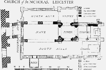
The church of ST. NICHOLAS (fn. 53) consists of nave and chancel, north and south aisles, and central tower. It is built immediately to the east of the site of the Roman forum, 12 feet separating the west end of the church from the Jewry Wall, and considerable use was made in building the church of the Roman material so close at hand.
The pre-Conquest remains of the church are the north and west walls of the nave and the wall above the 19th-century arch of the south nave arcade. Quoins of green sandstone of this early period survive at the south-west corner of the nave and at the base of the disused north-east angle of the chancel, which was the north-east corner of the early church. The ends of the middle pier of the north nave arcade are formed of large blocks of the same material. Above the north nave arcade are two small windows, the arches on both faces of the wall turned with two rows of Roman bricks. At the present time these windows are double-splayed but examination has shown that in both cases the inner ring of bricks on the outer side has been cut back and that the windows had originally only a single splay. These windows and the wall in which they are set date possibly from the 7th century and certainly from before the Danish invasions. This early church extended for the whole length of the present nave and chancel (the northeast angle has been mentioned above), and it seems likely that the Jewry Wall formed the western wall of the porticus, which, as at Brixworth (Northants.), was probably continuous round the nave; the nave was probably entered through arches in the side walls. Traces of rough foundation walls between the west end of the church and the Jewry Wall were discovered at the excavation of that site. This western porticus may have been designed for the instruction of catechumens. (fn. 54)
The second stage in the building took place in the last part of the 11th century, when building was carried out in brown sandstone, dressed with axes. At this time a central tower seems to have been built in stone to a height just above the roof line, and then probably completed in timber. The herring-bone arrangement of Roman tiles at the base of the tower dates from this time. A blocked opening in the north nave wall possibly led to a stair, and there may have been transepts to this church.
In the 12th century the tower was completed in grey limestone to its present height, two stories above and two below the roof line. The present arcade was cut in the north nave wall, and a similar arcade was probably cut in the south wall. That on the north (the only one surviving) is of two bays, the arches springing from the old central pier, which was redressed and chamfered. The wide blocked arch in the west wall and the south doorway with its simple hood and abaci with nail-head ornament are of the same date, probably the first half of the century.
The chancel of the 12th-century church was narrower than the nave and its walls were pierced, probably for chapels, early in the 13th century. The south arcade still survives and is of two bays with pointed arches. That on the north is of one bay and is now blocked up. There seems to have been a sacristy farther east on the north side, where a piscina remains in the outer wall. The south aisle, which runs the full length of the church, was added about 1300. The broach spire, which was demolished partly in 1805 and partly a short while later, (fn. 55) was probably added in the late 13th or early 14th century. The clerestory was built in the 14th or 15th century, when the nave walls were raised. The line of the original roof can be seen above the chancel arch. The timber-framed south porch was added in the 16th century. In 1697 the north aisle was demolished as it was dangerous, (fn. 56) and the north arcade was blocked. It is not known exactly when the aisle had been built. At the beginning of the last century the chancel was in use as a vestry and the altar was in the south aisle. (fn. 57) In 1825 a proposal was made to demolish the whole structure as it was held to be in an extremely dangerous condition. (fn. 58) Owing to the poverty of the parish, however, no funds could be raised for the proposed rebuilding, and nothing was done. Extensive alterations took place a few years later, when the south nave arcade was taken down and replaced by a large brick arch which spans the whole of the former arcade. The architect of this restoration and alteration was an otherwise unknown Mr. Mortin. The corporation subscribed two sums of £100 each towards the work. (fn. 59) The church was reseated at the same time. Restorations were again carried out in 1873–6, when F. W. Ordish rebuilt the old north aisle; (fn. 60) this was not carried to the length of the south aisle, and its east wall ends on a level with the eastern pillars of the tower. The wall is roughly filled with rubble masonry. This new aisle is wider than the former one. At the same time the porch was renewed, the interior walls freed from plaster, the window mouldings renewed and various other replacements were made. A new pulpit was made to Ordish's design, based on one in northern Italy. The church was again restored in 1904–5, when Charles Baker was responsible for securing the tower with steel supports and for restoring the outside of the tower, clerestory and north aisle. (fn. 61) Further restorations took place in 1949. (fn. 62) Nearly all the outer walls of the church show considerable signs of these various restorations, and most of the windows are modern.
There is an 18th-century sundial of Swithland slate on the south wall. The south aisle contains a mutilated piscina and triple sedilia. In 1929 this aisle was dedicated as a memorial chapel to Canon Edward Atkins. (fn. 63)
The font stands at the west end of the south aisle, and dates from the last century. (fn. 64) It is a square block of sandstone, with a scooped basin, supported on a single alabaster column. The old plate consists of a silver paten of 1706, a cup of 1714 and a cup and flagon of 1736. There are also three 18th-century pewter plates and some 19th-century silver. (fn. 65) The organ was installed in 1890. (fn. 66) There are three bells, all by unknown bell-founders, but cast in 1617, 1656, and 1710. Only that cast in 1710 is now used. (fn. 67) The registers date from 1560 and the churchwardens' accounts from 1761.
The churchyard was closed for burials in 1856. Part of it was taken for street-widening in 1898. (fn. 68)
Charities.
Francis Palmer gave at an unknown date an annuity of 10s., charged upon a house in Jewry Wall Street, to be distributed among the poor. In 1837 the money was being distributed by the corporation. (fn. 69) Sir William Wilson of Sutton Coldfield (Warws.) left, by will proved in 1710, a yearly sum of £10 from property at Sutton to be used for the apprenticing of poor children from the parish. The bequest was to take effect from 1792; in 1837 the children were being apprenticed mostly to framework-knitters. (fn. 70) Mrs. Elizabeth Clarke left £50 'by will in 1780' in trust for the poor. The parish added £5. The stock was apparently sold in 1801 to defray a debt of £130 for building at the workhouse. (fn. 71) By will dated 1821 Thomas Read left £50 in trust for bread for the poor on St. Thomas's Day. The interest was added to money received from the corporation and a substantial distribution of bread used to be made. (fn. 72) One other charity, Smart's Charity for bread, was lost before 1837. (fn. 73) One-half of the John Norrice Charity is payable to the vicar by the Trustees of the Leicester General Charities. The corporation pay sums to the parish under the Courteen and Ive charities, which also receives a share of the Heyrick Charity for bread from the Trustees of the Leicester General Charities. (fn. 74)