Survey of London: Volume 8, Shoreditch. Originally published by London County Council, London, 1922.
This free content was digitised by double rekeying. All rights reserved.
'Historical introduction: Shoreditch High Street, west side', in Survey of London: Volume 8, Shoreditch, (London, 1922) pp. 14-25. British History Online https://www.british-history.ac.uk/survey-london/vol8/pp14-25 [accessed 24 April 2024]
Shoreditch High Street, west side.
On the western side of the high road the parish of Shoreditch commenced at Worship Street (formerly Hog Lane). The whole of the northern side of that street, including the frontage to the high road as far as King's Head Yard (see Chassereau's Map, Plate 1), formed part of the prebendal manor of Norton Folgate. On 2nd October, 1639, Edmond Moore sold (fn. 1) to Thomas Large, four messuages lying between the King's Head and "the King's highway goeing unto the lane that leadeth from the streete unto the feild there" [Hog Lane], and two pieces of ground west of the messuages in question, and bounded south by the lane, west by the highway leading to Holywell [afterwards Curtain Road], and north by ground (a) "heretofore or late of Widow Man" and (b) "heretofore or late belonging to one William Herbert." (fn. 2) The property had previously belonged to John Roper and Christopher, his son, (fn. 3) and seems to have formerly been in the possession of John Parke, great-grandfather of Christopher. On 16th June, 1640, Large died, and his inquisition (fn. 4) mentions the property under the description of two messuages in Norton Folgate, in the parish of St. Leonard, Shoreditch, three messuages and five cottages in Norton Folgate, and two parcels of land called "pightells" containing by estimation two acres "lying in the aforesaid parish near adjoining the last recited messuages." The property, which is said to be held of the Dean and Chapter of St. Paul's as of their manor of Norton Folgate, descended to Large's daughter Katherine, who had married John Archer. On 8th November, 1651, John and Katherine Archer leased the "pightells" to Richard Punne for a term of 45 years, and when the remainder of the term was transferred to John Cliff and Geo. Herne on 18th May, 1680, twenty-four houses had been built, some certainly and all probably on the north side of Hog Lane. (fn. 5)
It is evident from the above that this piece of property of St. Paul's reached from Shoreditch High Street to Curtain Road, but its northern boundary (with which is bound up the southern boundary of Curtain Close) is uncertain. If the acreage of the property is to be depended on, however, it must have reached at least as far as the southern side of Hearn Street.
The spur of Stepney Manor, which has been met with on the east side of the high road, continued on the west side. In this case also, its limits are uncertain. Southward it extended at least as far as Talbot Alley (Stocking Frame Alley), which in a deed of 1640 (fn. 6) is definitely stated to be within the manor. Northward it took in The George, which, with the ground in the rear (fn. 7) extending for a distance of 112 feet behind the house, east to west, and 90 feet north to south, was from 1618 to 1634 (fn. 8) held of the lord of Stepney Manor.
Nos. 217, 218 and 219, in the high road, were still copyhold when purchased by the Metropolitan Board of Works in 1874. No. 213 was also part of the manor. John Wild of Edmonton, by his will (fn. 9) dated 12th April, 1662, left two customary messuages for charitable purposes, "which messuages he has surrendered in the Stepney Manor Court to the uses of his will," and these in 1825 were represented by No. 213. (fn. 10) These houses must have been close to, or may even have included, a house of the brothers Burbage, for the rear portion of The George property is said in 1619 to have been bounded on the east by "the landes and tenementes of Cuthbert Burbage and Richard Burbage, Henry Thorne deceased, and Thomas Thornton." This Burbage property is known to have formed part of the manor. (fn. 11)
Whether the manor extended north of The George there is no evidence to show. If such was the case, however, it was for a very short distance, for in 1558 the nine houses south of the corner house of Holywell Lane were held of the King. (fn. 12)
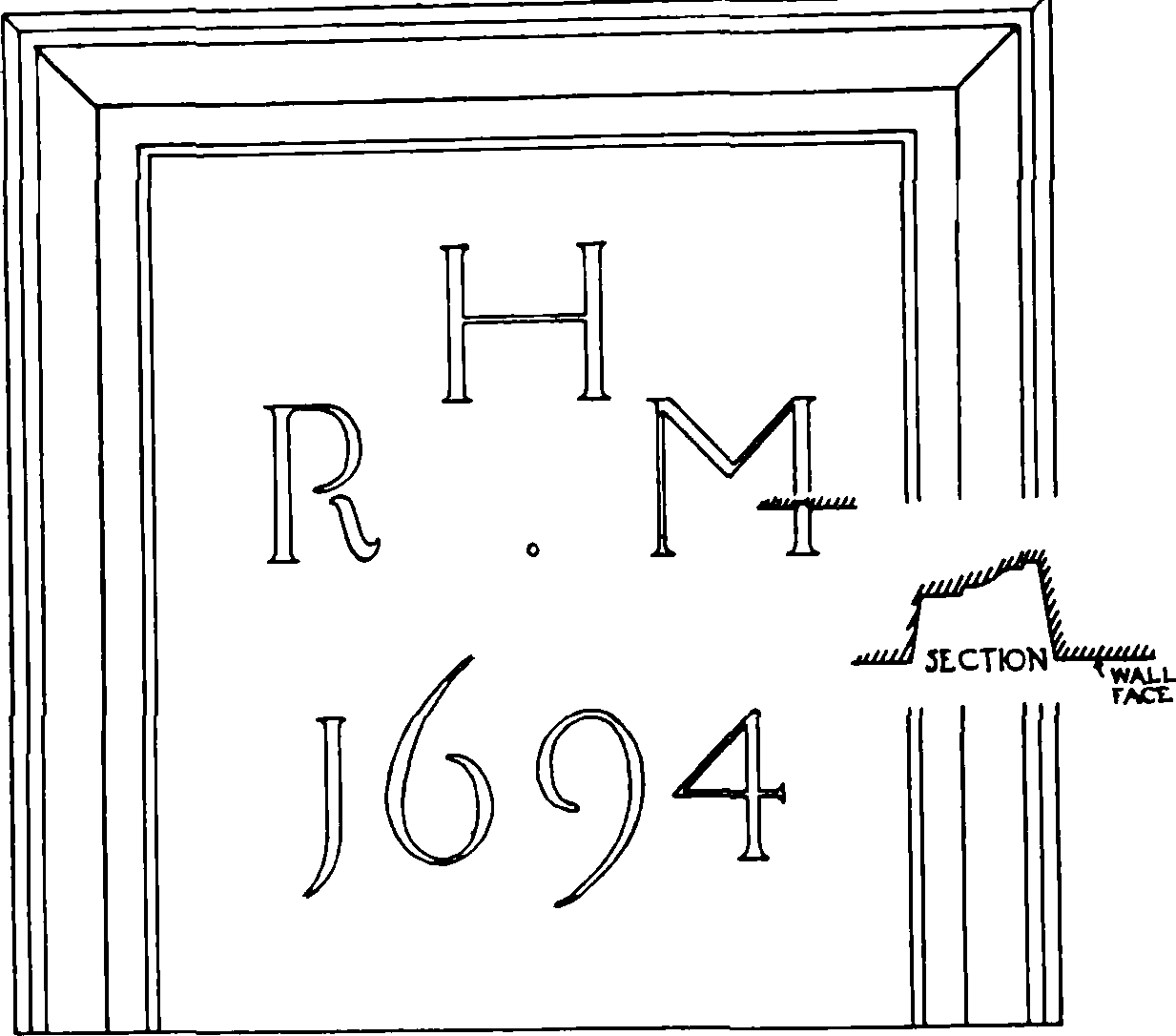
Stone tablet, dated 1694, on front of No. 197, Shoreditch High Street.
One of the houses in question (No. 197) appears to have been rebuilt in 1694, a tablet being affixed as follows— but no information concerning it has come to hand in the course of the investigations for this volume. The house must have been again rebuilt in the early part of the 19th century, when the tablet was refixed.
The greater part of the land behind the premises in the high road consisted of a close of pasture, belonging to the priory of Holywell, called Curtain Close. It reached as far as what is now Curtain Road on the west and Holywell Lane on the north, but stopped some distance north of Hog Lane on the south. On the east it included the site of what was afterwards Sugar Loaf Yard, (fn. 13) the boundary on this side corresponding roughly with the North London Railway.
On 27th May, 1537, the prioress leased to Dr. Thomas (afterwards Sir Thomas) Legh (fn. 14) for a term of 99 years, a number of fields and pastures belonging to the priory (fn. 15) including "a pasture bryckwalled aboute lying of the southe syd of my lord of Ruttelande place." (fn. 16) On 9th June, 1545, the freehold of the fields, etc., was granted by the king to Lord Wriothesley. (fn. 17) The pasture in question was described as "a close there enclosed with a stone wall on the south side of the mansion of the earl of Rutland, in tenure of Thomas Leigh, doctor of laws." On 25th September in the same year, Wriothesley transferred his interest to Legh, who was accordingly in possession of both of the freehold and the long lease.
On 20th February, 1566–7, Sir James Blount, Lord Mountjoy, and Lady Katherine, his wife, Legh's heiress, sold the close (fn. 18) to Maurice Long and William his son, the latter of whom, on 18th March, 1580–1, transferred it (fn. 19) to Thomas Harbert. It is described as "all that the house, tenemente or lodge commonlie called the Curtayne. And also all that parcell of grounde and close walled and inclosed with a bricke wall on the west and northe partes and in parte with a mudde wall at the west side or ende towardes the southe, called also the Curtayne close . . together with all the gardeyns, fishepond, well and brickwall to the premises . . . belonging." Also all other messuages, etc., built on the close, in tenure of Thos. Wilkinson, Thos. Wilkins, Robt. Medley, Richd. Buk, Henry Lanman, (fn. 20) and Robt. Manne, and messuages, etc., in Holywell Lane.
It will be seen that the development of the close had now begun and this process was henceforth steadily continued. The 99 years' lease granted to Legh had come into the hands of William Middleton, who is stated to have built certain houses there. (fn. 21) He died about 1586, and Thomas Harvey, who shortly afterwards married the widow, recalls the fact that after he "came to have any meddling with the said leas of the Curteyne . . . by his meanes the grounde there was for the most parte converted firste into garden plottes and then, leasinge the same to divers tenauntes caused them to covenaunt or promise to builde uppon the same, by occasion whereof the buildinges which are there were for the most parte errected, and the rentes encreased." (fn. 22)
Harbert died on 12th November, 1608, and all his property in Shoreditch came into the hands of Roger Papworth, one of his nephews. By indenture of 1st January, 1608–9, it was transferred to Thos. Catchmay and Thos. Wood, (fn. 23) who on 1st July, 1611, sold the close to Edward Morris, (fn. 24), and he, on 20th March, 1611–2, transferred the property (fn. 25) to Thomas Baldwin and Katherine, his wife. On Baldwin's death in 1639–41, the reversion of his "landes, tenementes and hereditamentes called . . . by the name of the Curtain . . . in or at Holywell in the parish of St. Leonard in Shoreditch," came to his niece, Katherine Higgins. (fn. 26) Mrs. Higgins afterwards became a widow and in 1666 married again, her second husband being Sir Clement Farnham. (fn. 27) The property was afterwards mortgaged by Baldwin Higgins, her son, to Francis Smith, (fn. 28) who, by his will dated 14th July, 1703 (fn. 29) bequeathed to Francis and Nicholas Coleman "all those my lands lying in Shoreditch . . . commonly called . . . the Cur tain and all messuages or tenements, erections and buildings, thereupon erected and built."
On 22nd June, 1724, Francis Coleman, the surviving brother, sold it to Woolaston Shenton, citizen and "silkthrowster" of London. By combining the information contained in the deeds (fn. 30) accompanying the transaction with that given in certain other documents about the same time, a fair idea can be obtained of the appearance of the close. (1) There was a large nucleus of open ground described as garden ground, but which was already used as a tenter ground. (fn. 31) It is said to contain "by estimacion" 5 acres, but the estimate was a distinctly generous one. (2) To the north of this and occupying all the frontage to Holywell Lane, west of the site of the North London Railway, were: (a) Sugar Loaf Court, 58 feet; (b) the "Flower de Lewis," 34¼ feet; (c) 10 messuages, 146 ft. 10 ins.; (d) a passage leading to the open ground, 42 feet; and (e) waste ground extending to "a street called the Curtin" [Curtain Road], 71 feet 10 ins. = 353 feet. With the exception of Sugar Loaf Yard, which had a depth of 118 feet, all the above-mentioned properties extended 60 feet southwards, to meet the open ground. (3) The open ground extended westward to Curtain Road for only a portion of its depth; for the remainder of the distance it was bounded by certain buildings known as Buffington's Buildings and Howard Buildings, (fn. 32) which had been built on part of the close (4) South of Howard Buildings, and at the extreme south-west end of the close were two messuages. (5) There were two other small portions of ground, of about 2 roods and ½ rood respectively, adjoining the inner ground, but their exact position is not stated.
Immediately east of the Holywell Lane frontage of Curtain Close were certain stables in the occupation of the earl of Rutland. On 1st January, 1537–8, the prioress of Holywell demised to the earl for a term of 58 years two stables and a hayloft built over, situated outside the gates of the priory near the pasture of the prioress called "the Curten." The lease was surrendered in 1585, to the Queen, who regranted the property to the earl for 60 years. (fn. 33) With the remainder of the Rutland estate in Holywell it was granted to Geo. Salter and John Williams in 1610 and in due course passed to Joseph Newsom in 1763. (fn. 34) In the indenture of bargain and sale on the latter occasion occurs a reference to "all those messuages, tenements and ground, lying over against Holywell Gate on the south side of Holywell Lane," which obviously represent the earl's stables and hayloft. The property is further detailed a few years later in a lease of Newsom's executors (fn. 35) as "a parcel of ground on the south side of Holywell Lane, with frontage, west to east 42 feet 6 inches, depth north to south, 104 feet 6 inches, east to west at the south end 41 feet 6 inches, with two messuages . . . thereon." On 8th January, 1782, Newsom's widow sold to Thos. Patey all those two messuages . . on the south side of Holywell Lane opposite the gateway there leading into King John's Court . . and also all those two new built messuages . . . lately divided into or used as three messuages . . . situate and being behind the other two messuages." (fn. 36) The number of houses in the rear was afterwards increased, and when in 1864 the North London Railway Company purchased the property it consisted of Nos. 54 and 55, Holywell Lane, and Nos. 1 to 10, Patys Court. (fn. 37)
South of the Rutland stables was a strip of ground 31 perches long and 2½ perches wide, formerly part of the possessions of Holywell Priory and granted by Henry VIII. to Christopher Campion and John Rollesley (fn. 38) on 8th September, 1544. Its boundaries are given as: north, the stables late in tenure of the earl; south, the great tenement at the end of the close called "le Curteyn"; west, the close called "le Curteyn"; east, the royal way [i.e., the houses in Shoreditch High Street]. It will be seen that the width of the strip corresponds exactly with the southern width of Patys Court, a fact which confirms the identification of the latter with the site of Rutland's stables.
At the time of the dissolution the stables were flanked on the east by two "tenements, or cottages," held of the priory of Holywell by Maurice Knevett on a lease of 61 years. (fn. 39) On 5th November, 1544, these were granted to Robert Curson and John Pope, (fn. 40) and for the next twenty years their history is lost. (fn. 41) On 9th September, 1566, Sir Thomas Davis (or Davie), a citizen and clothworker of London, died, leaving, inter alia, a "house and garden in the parish of St. Leonard's, Shoreditch." (fn. 42) His son John grew up, became Sir John Davis, and was subsequently attainted under Elizabeth. On 24th January, 1610–1, James I. granted to him that property "which ought to have come unto the handes of our late deere sister Elizabeth, or unto us, by reason of the attaynder." It is described as "all that one messuage or tenement and dyvers little cottages or chambers and one garden or voide peice of grounde with appurtenances scituate in St Leonard, Shoreditch, sometyme in tenure of Willyam Corey, clarke, and Alice his wife, and John Bagley . . . and now or late of Anthonye Glover . . . which premisses doe conteyne in length from the streete or highwaye there unto the south 117 feet 2 ynches and in breadth from the east parte of the premisses unto the west parte 48 feet 4 ynches." (fn. 43)
In 1623 Sir John Davis sold the property to George Layton, (fn. 44) and on 16th January, 1631–2, Thomas Layton conveyed it to Sarah Layton, (fn. 45) who died on 17th December, 1640. Her inquisition (fn. 46) identified the property with that granted to Curson and Pope and in the tenure of Maurice Knevet, and stated that it then consisted of two messuages, ten cottages, two curtilages and two gardens. In accordance with the terms of her will it was left to trustees with instructions to sell and invest the proceeds in the purchase of tenements in the City for the use of her grandchild, Samuel Gibbs. On 15th June, 1651, Samuel, in conjunction with his trustees, sold the property to Anthony Ferrer. (fn. 47) It is described as consisting of "all those messuages or tenements with the gardens, backsides and parcells of ground thereunto belonging or adjoining, with the bowling alley there, scituate in Hollowell Streete . . . contayning from the north to ye outhouse belonging to ye George Inn or Brewhouse on the south part 117 feet 2 ynches and in breadth from ye pale to ye east part of the garden unto certaine tenementes on the west heretofore ye stables of the earle of Rutland on the west 48 feet 4 ynches." From its position with regard to Rutland's stables, it is evident that the property included the site of Red Lion Court. This is confirmed by Anthony Ferrer's will, dated 7th July, 1652, (fn. 48) which mentions the messuage called the "Redd Lyon" with another messuage adjoining, "as they are scituate lying and being in Holloway Lane," as well as other messuages near by.
As regards the property lying between Sir John Davis's estate and the high road there is no information whether or not it belonged to Holywell Priory. It is first met with in 1555 when Sir Roger Cholmley sold to Thomas Hubott "all that his mesuage or tenement called the Hande and the "Flowre" and other messuages in four occupations. (fn. 49) More definite particulars are contained in connection with the sale by Hubott to William Beswick on 24th June, 1561. (fn. 50) The houses are said to lie between the house and garden of Thos. Davyson of London, clothworker, (fn. 51) on the west, the King's highway on the east, the house and garden of William Underhill, (fn. 52) south, and "Hallywell Lane," north, and the property is said to be 160 feet long and 22 feet wide. Four months later Beswick sold the property to John Nysam, (fn. 53) who, on his death in 1570 left to his youngest son, John, his free messuages, etc., "late purchased of William Beswick in Holywell Street." (fn. 54) With the exception of a single reference (fn. 55) a few years later, trace of the property is then lost until it reappears (fn. 56) in 1614–15 in two portions, together forming ten houses. The one portion, consisting of "all that "corner house . . . and all those five messuages, tenementes or cottages . . . to the said corner house next adjoining" was sold by Geo. Kilner on 30th Decr., 1614, to John Cattringham, (fn. 57) and can be traced without difficulty to 1683, (fn. 58) when Edward Simeons left to his son Edward (fn. 59) his six freehold messuages or tenements. The other portion, comprising four messuages, and described as adjoining a house of Mary Glover, towards the west was sold by Hugh Lobley to John Idell on 24th July, 1615. (fn. 60) How Lobley had obtained it is not said, but the indenture, by recording the fact that a part of the premises was under a lease granted by Geo. Kilner on 8th January, 1610–11, makes it clear that Kilner had been in possession of the property. (fn. 61)
Between Holywell Lane and the site of Bateman's Row was the Augustinian Priory of Holywell, a full account of which is given on pp. 153–187. Further to the north, was a close of pasture, belonging to the priory, called Fairfield. This and an adjoining close were included among the properties which were leased to Sir Thomas Legh in 1537 (fn. 62) and of which the freehold subsequently came into his hands. They are described as "two cloises next adjoininge to the brick wall of the north syde of the said monastery . . . the one called faire feild lying between the common way of Shordiche and the parishe churche of Shorediche. The other cloise is called and lyethe betwen Finsbury feild of the southe parte, and the well called Dame Agnes A Clere of the west parte, and the way called Hoxdone way of the north parte, and the cloise called Fairfeild of the este parte." (fn. 63) In 1555 Sir Thomas Chaloner and Lady Joan, his wife, widow of Sir Thomas Legh, obtained licence to alienate to John Mascal and Dorothy, his wife, the close called "Fayrefeld" and the unnamed close, (fn. 64) and sixteen years later Sir James Blount, Lord Mountjoy, and Katherine his wife, heiress of Sir Thomas Legh, transferred their interest to Dorothy Mascall, now a widow, and John her son. (fn. 65) Eventually the property came into the hands of Thomas Kemp and Anne Watts (née Mascall) in the proportion of three-fourths and one-fourth respectively. (fn. 66) On 4th October, 1627, Kemp sold his share to Randolph Crewe, (fn. 67) and some seven years later Crewe purchased Anne's interest. (fn. 68) On Crewe's death the property was divided. The greater portion came into the hands of his second son Henry, who on 23rd June, 1651, sold it to Thomas Byde. (fn. 69) In addition to certain houses and tenements it comprised a parcel of garden ground containing 7 acres late in the tenure of John Richars and then in that of John Noble, "which doth abutt in parte upon the highway leading down to Shoreditch Church towards the east, upon another parcel of garden ground there late in the tenure . . . of William Wood gardner . . . towards the west, upon certayne almshouses of Shoredich (fn. 70) towards the north, and in parte upon the common sewer running between the said parcell of garden ground and the waste ground lying on the north side of the brickwall of Hallywell towards the south," as well as another parcel of garden ground, containing 6 acres, late in the tenure of William Wood and then in that of John Noble, (fn. 71) "and doth abutt uppon the highway leading to Hoxton on the north, upon Finsbury Field on the south, a parcell of garden ground late in the occupation of one Robert Badger, since of Robert Kettle and now of David Vollett gardner . . . on the west, and upon the aforesaid parcell of garden ground now in the occupation of John Noble on the east."
A few weeks before, George Price, Crew's executor, had disposed of other portions of the estate. The largest of these sales was on 20th May, 1651, to William Billing (fn. 72) of that property which formed the western boundary of the last-mentioned. It is described as "all that his parcell of ground, . . . containing foure acres, late in the occupation of David Vollett gardner . . . . and now in that of John Hollam, yeoman . . abuttinge west on Dame Agnes of Cleere, east on other garden ground late in the occupation of William Wood . . ., south on Finsbury Feild, and north upon the highway leading to Hoxton."
From the several descriptions given above, the northern (Old Street), eastern (Shoreditch High Street) and southern (Holywell Priory precinct, and the northern boundary of Finsbury Field, i.e., Willow Walk, now merged in and roughly represented by Great Eastern Street) boundaries of Fair Field and the unnamed close can be deduced. The western boundary can only be decided in conjunction with the eastern boundary of Dame Agnes A Clare. (fn. 73) This result can be confirmed by reference to Chassereau's Map (Plate 1).
On 25th May, 1653, Byde sold (fn. 74) his portion of the property to Thomas Turgis, and on 12th October, 1704, Mary Turgis disposed of it (fn. 75) to William Urry, in whose family it continued for many years. (fn. 76) Chassereau's Map shows Urry as owning all the land north of Bateman's Row, while that lying to the west of the site of Curtain Road is divided between Urry and Taylor. Taylor's land obviously represents the four acres sold to William Billing.
Chassereau, in fact, makes it clear that the original pasture extended eastwards and northwards at least as far as (1) the backs of the houses in the high road, and (2) the rear of Fuller's Almshouses in Old Street. As regards (1), however, there can be little doubt that Fairfield at the time of the dissolution extended to the road. A plan of so much of Urry's estate as in 1834 remained in the possession of his successors in title (fn. 77) shows that it comprised even then some properties in the high road north of William Street, and, in addition, the sites of Nos. 138–9 and 143–4 can be shown to have originally formed part of Urry's estate. (fn. 78) The assertion cannot be made with so much confidence in the case of (2). The date of the erection of the almshouses cannot be definitely ascertained, (fn. 79) but no record has been discovered of a sale of any portion of Fairfield for the purpose. On the other hand, it is known that a rent of 5s. a year was paid to the prebendary of Hoxton in respect of the site, and it seems probable that the ground was not originally a portion of Fairfield, but a piece of waste belonging to the Hoxton prebend.
Rocque's and Chassereau's Maps show that up to the middle of the 18th century building on the two fields was confined to the high-road frontage and the north-east corner of Fairfield. The formation of the northern half of Curtain Road about this time (fn. 80) brought about a great change, but even at the end of the century large portions were still uncovered with buildings.