A History of the County of Cambridge and the Isle of Ely: Volume 10, Cheveley, Flendish, Staine and Staploe Hundreds (North-Eastern Cambridgeshire). Originally published by Victoria County History, London, 2002.
This free content was digitised by double rekeying. All rights reserved.
'Fulbourn', in A History of the County of Cambridge and the Isle of Ely: Volume 10, Cheveley, Flendish, Staine and Staploe Hundreds (North-Eastern Cambridgeshire), (London, 2002) pp. 130-136. British History Online https://www.british-history.ac.uk/vch/cambs/vol10/pp130-136 [accessed 25 April 2024]
FULBOURN
Fulbourn, which until 1876 comprised two ecclesiastical parishes, (fn. 1) lies almost 7 km. (4 miles) east of Cambridge. Approximately rhomboidal, (fn. 2) it covers 2,130 ha. (5,263 a.). (fn. 3) The straight boundary to the south-east follows the line of the Icknield way, (fn. 4) which from 1724 to 1871 formed a section of the turnpike between Great Chesterford and Newmarket. (fn. 5) That to the south-west ran along the line of another ancient road, called locally by 1200 Wulves street, (fn. 6) and by 1800 identified as part of a Roman road. (fn. 7) The north-east boundary partly follows the Fleam Dyke, styled locally by 1325 the Mickle ditch. (fn. 8) From Shardelowes well (fn. 9) at the dyke's north end it runs along the edge of Fulbourn fen, following the slightly altered course of a stream, called the Little Wilbraham river, which meanders northwards and westwards to meet at the parish's northern extremity another stream called c. 1279 Caldwell, (fn. 10) later Caudle, ditch, which flows north-eastwards from near Cherry Hinton. There the boundary may once have been undefined: when Fulbourn was inclosed, Hinton rectory shared the tithes of Catchpole furlong (26 a.) near the north-west corner. (fn. 11)
Fulbourn lies mainly upon chalk, overlaid along the stream to the north-east with alluvium and river gravels. Drift deposits are scattered (fn. 12) on the higher ground, at over 50 m., beside the Roman road, from which ridges, divided by narrow dips and rising in places, as at White Hill (so named by 1360), (fn. 13) and Limepit Hill, to over 60 m., stretch north-east almost as far as the village. That is sited near the fen at c. 15 m. From there the ground rises steadily southeastwards to c. 40 m. near the Icknield way. Much of the northern quarter of the parish, mostly level at c. 10 m., was fenland until between 1806 and 1812, when a system of drainage channels, still existing in the 1990s, was created. (fn. 14) Each side of a slight rise was used as arable from the Middle Ages. From 1965 40 a. of Fulbourn fen east of the village was entrusted by its owners, the Townleys, to the Cambridgeshire Naturalists' Trust for management as a nature reserve. (fn. 15) Between heath common to the south and that fen pasture to the north, (fn. 16) the central part of the parish was until 1808 cultivated as four open fields under a triennial rotation. Most of the land remained in 1990 arable farmland, the village, its population much enlarged by new housing from the 1950s, being then precariously (fn. 17) separated from the advancing suburbs of Cambridge by a narrow strip of green belt west of the county Mental Hospital.
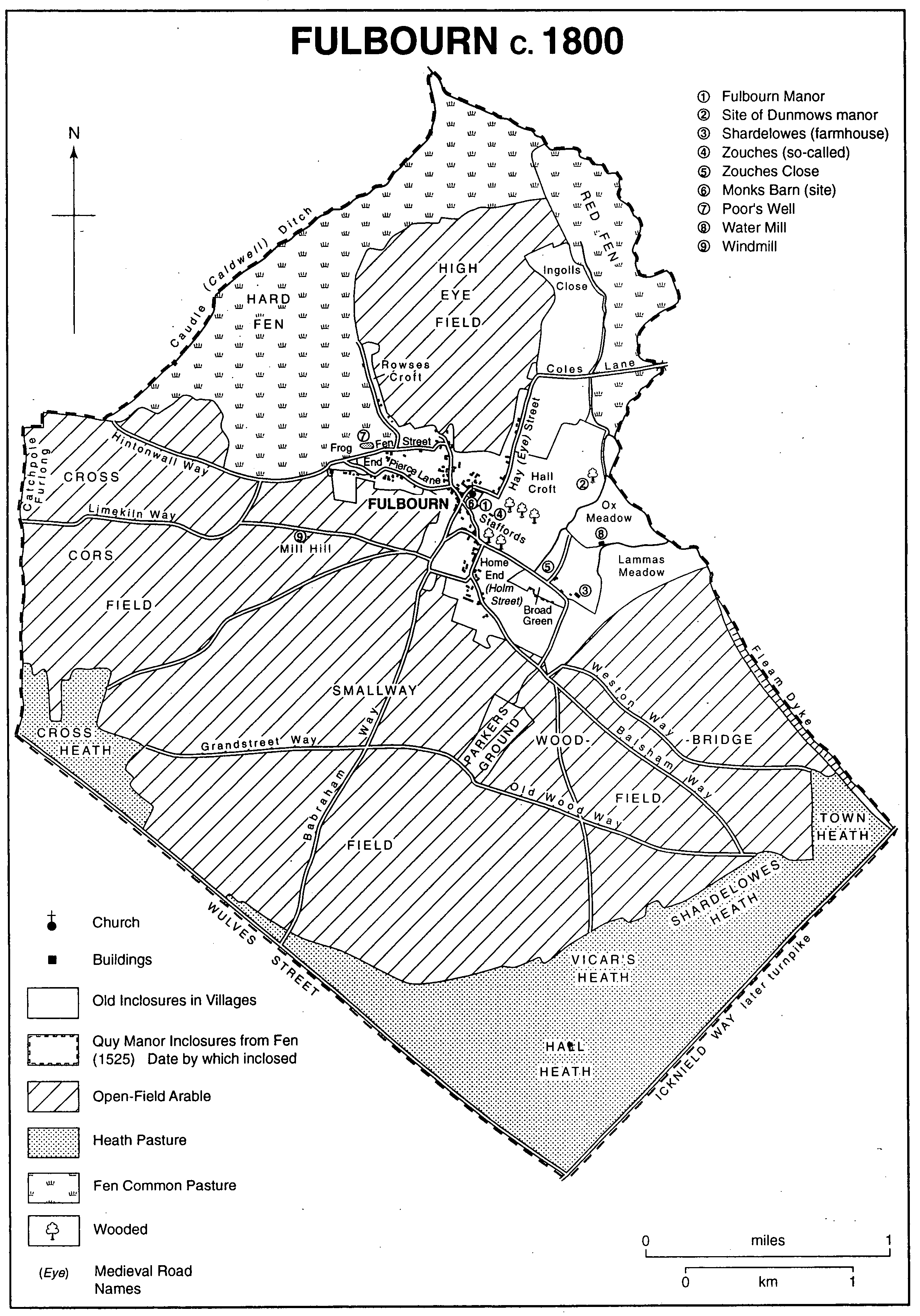
Fulbourn c.1800
A section of the ancient Street way, possibly that called locally by 1300 Grauntestreet, later Grandstreet, way, (fn. 18) ran from the parish's western edge to pass the northern end of the Fleam Dyke. (fn. 19) Few prehistoric remains have been found, except for some Bronze Age weaponry. (fn. 20) A probable Roman settlement has left traces in inclosures and droveways visible near the western boundary. (fn. 21) A Roman cemetery containing up to 30 skeletons was discovered in 1874 north of the village, along with an excavation variously identified as a limekiln and a tiled grave. (fn. 22) Another Roman limekiln was found further east in 1875 near the then station, (fn. 23) close to which a Roman pavement was discovered c. 1940. (fn. 24)
The parish was well populated from the Middle Ages. In 1086 there were probably c. 90 peasant households, (fn. 25) and by 1279, when 56 messuages and 20 cottages were recorded, c. 275 probably resident landholders. (fn. 26) Some 80 inhabitants paid tax in 1327 (fn. 27) and 426 adults paid the poll tax in 1377. (fn. 28) There were still 119 people assessed to the subsidy in 1524, (fn. 29) and 105 households in 1563. (fn. 30) Following subsequent growth from the 1570s, numbers may have ranged between 400 and 450 in the late 16th and early 17th centuries, increasing again from the 1620s. (fn. 31) In the 1660s and 1670s 105-110 dwellings were occupied, (fn. 32) and 107 adults were reported in 1676. (fn. 33) There were 106 families in 1728. (fn. 34) The population was probably again stable in the early 18th century, perhaps dropping slightly c. 1740, but began to rise from the 1750s, perhaps by a half by the 1780s. (fn. 35) There were 166 households in the 1790s and 702 people in 1801. (fn. 36) Until the 1840s numbers grew by c. 150-200 in each decade, reaching 1,023 in 1831 and 1,452 in 1851. (fn. 37) Pressure was reduced in the 1850s by emigration, especially to Australia. (fn. 38) The population stood at c. 1,385 in the 1870s before again declining steadily, (fn. 39) with the sharpest fall in the 1890s when many young people left, (fn. 40) to c. 1,200 between 1911 and 1931. (fn. 41) Of over 180 men who fought in the First World War 37 perished. (fn. 42) New building, which added 250 households to the village in the 1950s and 520 in the 1960s, increased its population to 1,396 by 1961, 4,139 in 1981, and 4,732, including 4.282 in private households, in 1991. (fn. 43)
The village was established, probably by 1200 at latest, in the east of the parish, near the waterfowl-frequented stream after which it was named, and close to the division between arable and fenland. By the late 13th century it was linked to the Icknield way by fieldways leading south-east including Weston, Balsham, and (Old) Wood ways, while Mill and Granditch ways, continued respectively by Limekiln and Hintonwal(d) ways, led west towards Cherry Hinton and Cambridge. (fn. 44) At inclosure those running south-east were mostly stopped up, and replaced by a single straight one, while the western ones had their courses straightened. (fn. 45) Under an Act of 1845 the Newmarket Railway Co. built across the south-east of the parish a section of its line from Great Chesterford to Newmarket, opened in 1848. A station was put up on the Balsham road, whose building was demolished after 1930; various cuttings and a bridge were visible in the 1980s. That line, closed in 1851, was formally abandoned in 1858, after the company had built the direct line from Cambridge, which crosses Fulbourn north of the village to join the earlier line at Six Mile Bottom. A new station for Fulbourn was opened by 1852 on Hay Street, (fn. 46) in the 20th century renamed Station Road. That station was closed in 1967 and its buildings demolished after 1973, (fn. 47) although the line remained open for infrequent passenger traffic in 1990.
By the 18th century dwellings in the village mostly stood toward the eastern end of c. 200 a. of surrounding crofts and closes. (fn. 48) A main street, probably called by 1370 Church Street, (fn. 49) linked two groups of tenements along Holm street to the south, so named by 1200, (fn. 50) later called Home End (Street), and along Eye street, (fn. 51) corrupted after 1400 to Hay Street, (fn. 52) to the north-east, along whose western side crofts, some walled, abutted upon Eye field in the 1310s. (fn. 53) In the late Middle Ages Holm and Eye streets were possibly reckoned as separate settlements, being still separately enumerated in manorial rentals c. 1435. (fn. 54) From the main street another, the modern Cow Lane, probably called in the 13th century Fen street (fn. 55) and in the 14th Low or Nether street, (fn. 56) led west towards the village's main watering place, Poor's Well. Possibly in use by 1335 and so named in 1437, (fn. 57) it was designated for that purpose at inclosure. (fn. 58) Cow Lane then joined a back lane to the south named by 1500 Pierce lane. (fn. 59)
Of c. 40 houses surviving in Fulbourn in the 1980s from before 1800, mostly timber-framed, some under later brick casing, and half still thatched, (fn. 60) most stood towards that eastern end of the village, where housing had largely been concentrated in 1800. A few others then stood along the south side of Pierce lane or at Frog End to the west. Those older houses include c. 10 dating from before 1600, among them some manorial farmhouses. The former Highfield Farm had a 14th-century hall with arched heads to its screen openings, and a two-bayed cross wing; it had another cross wing added after 1600. At Home End the originally 15th-century Old House had its hall reconstructed in the mid 17th century, soon after a parlour cross wing had been added, while at Ludlows, behind a Victorian front, was another early 15th-century hall with an original doorway and six-light window; its soller cross wing comprised a parlour below and two chambers above. Those houses mostly had crownpost roofs, into which red brick chimneys were inserted in the 16th century or later. At Flendyshe House, facing Ludlows where Home End widens into a small green, a rendered façade of c. 1807 covered an early 17th-century range with a rebuilt service wing to the rear. Over 20 smaller houses of 2-3 bays and single-storeyed cottages with dormers dated from 1700 or earlier, some from the 1660s. During the 18th century a line of eight two- or three-bayed cottages, one dated 1735, were built on small crofts south-west of the village along the south side of Broad Green, so named by 1460, where dwellings had been recorded by 1506. (fn. 61)
In the 1660s and 1670s barely 20 of the recorded dwellings had had more than one or two hearths. (fn. 62) About 1808 the village contained at least 78 houses, including 15 farmhouses, and 42 cottages. (fn. 63) There was rapid growth after the 1820s, the number of inhabited dwellings rising from 164 in 1831 to 270-310 between the 1840s and 1900; in the late 19th century another 15-25 were sometimes empty. (fn. 64) Meanwhile new farmhouses had been built on the former open fields to the south and west, including Bishop's Charity (c. 1833-5), (fn. 65) Rectory (1827), (fn. 66) Valley (by 1829), (fn. 67) and New Shardelowes (1820 × 1835) Farms. (fn. 68) In the village other farmhouses went up on the standard Cambridgeshire pattern of a symmetrical three-bayed grey brick front, sometimes with fieldstone sidewalls, besides rows of labourers' cottages off the main streets, (fn. 69) some in brick.
By the mid 19th century (fn. 70) there were c. 40 houses along the main street, usually still called Church Street, and its northern extension named by 1506 Apthorpe Street. (fn. 71) Another 35-45 lay in a ribbon along the west side of Hay Street, where two more elaborate terraces of brick cottages were put up in 1885 and 1903. There were almost as many around Home End, with c. 10 by Broad Green. Another 45-50 reached along Pierce Lane to Frog End, but the parallel Cow Lane to its north was hardly built up. By 1800 a few dwellings were scattered along the roads to Teversham and Cherry Hinton. (fn. 72) In 1910 c. 80 houses were reported and 190 cottages. (fn. 73)
The early 20th century saw little growth, only 340-50 dwellings being recorded in the 1920s, (fn. 74) but c. 50 had been added by 1951, mostly before 1939, including many council houses. The first 12 had been built in 1925, some near School Lane, and 40 more went up in 1931 and 1939 within the angle of the Cambridge and Shelford roads. (fn. 75) By 1950 ribbon building had filled the recently empty east side of Hay Street. From the 1950s, following the arrival of mains drainage, the village was subjected to intensive devel opment, (fn. 76) some 280 new houses being built by 1961 and another 500 by 1981. (fn. 77) Planning restrictions confined them within the village's previous boundary: some new building was effected by infilling along the older streets, which had c. 280 dwellings by 1980 and were almost continuously built up by 1990. (fn. 78) Other new housing, totalling 600 dwellings by 1980, lay on c. 25 new roads, often densely packed closes, laid out within them. Private building, beginning at the east end, where c. 160 houses went up in the 1950s, spread westwards along the south side of Pierce Lane, where c. 120 were built in the early 1950s and, after a pause 1965-75, 30 more in 1977-9. Meanwhile new council housing was concentrated on the south edge of the village, c. 50 dwellings rising in the 1950s east of the previously almost unoccupied Haggis Gap, while another 170 were put up to its west c. 1965-6. That last estate consisted of factory-built dwellings, sponsored by an enthusiastic council chairman, (fn. 79) which were square, grey, and 'barrack-like'. (fn. 80) By 1974 the council had also built sheltered housing for 40 old people in Home Close at Frog End; (fn. 81) from 1981 similar wardened housing, comprising 33 bungalows, was established further south in 1983. (fn. 82) The 1980s saw less extensive new building, although infilling with smaller groups in the remaining gaps continued, as along Cow Lane. (fn. 83) In 1981 the 1,188 homes in the parish included 353 council houses, reduced by 74 by 1991, and 709 owner-occupied ones, only 126 being privately rented. Of c. 450 dwellings added in the 1980s almost all were privately owned. (fn. 84)
The village had numerous alewives by the late 14th century, (fn. 85) sometimes presented for not putting up their 'alethorp' and for late-night opening. (fn. 86) Three public houses were recorded from c. 1770: the Plough and Crown, renamed from 1776 the Six Bells, occupies a four-bayed timber-framed house of 16th-century origin with a jettied first floor rising over a coach entrance, later blocked. The adjoining Coach and Horses, first kept by the squire's coachman, and the Harrow, in a 17th-century house, (fn. 87) which closed respectively in 1902 and 1911, (fn. 88) stood nearby along the main street. After inclosure the White Hart, occupying a new grey brick house, was opened at Home End. In the early 19th century they were taken over, following bankruptcies, by Cambridge breweries. (fn. 89) Several others were opened from the 1830s, nine in all by 1858, some in new built premises, (fn. 90) including one near the station from 1859, when there were four public and six beer houses. (fn. 91) Their clubrooms accommodated friendly societies such as a Lodge of Oddfellows set up in 1846, called the 'Loyal Townley' after the squire, (fn. 92) and from the 1880s to the 1920s a branch of the Ancient Shepherds. (fn. 93) There were 10-11 licensed premises, one to every 120 inhabitants, c. 1910, (fn. 94) and still eight in 1937, (fn. 95) but their numbers were gradually reduced, one of the last four closing 1990-1, (fn. 96) leaving one public house by the Teversham road, and the Six Bells and White Hart, the former remodelled after fire damage in 1963 and again in 1985. (fn. 97)
By the mid 18th century Fulbourn's village feast was held on three days after the first Sunday after Trinity. (fn. 98) Described in 1881 as a 'noisy ... annual nuisance', (fn. 99) it was formally reduced to two days in 1883. (fn. 100) Despite objections to its obstructing the streets and to the gipsy showmen's insanitary habits, (fn. 101) it remained well attended into the mid 1910s. (fn. 102) Held from 1920 after Midsummer behind the Six Bells, it survived until 1936. (fn. 103) It was supplemented by an annual flower and fruit show held from 1880 in the squire's grounds by the village's Horticultural Society. (fn. 104) That also lapsed in 1937 for lack of organizers, (fn. 105) but was revived in conjunction with Teversham from 1956. (fn. 106) Other fêtes included the regular celebration of Empire Day by the schoolchidren between 1907 and c. 1940, (fn. 107) and others sponsored by the village Labour party from the 1920s. (fn. 108)
The village was well supplied from the 19th century with institutions providing social activities, and venues for them. (fn. 109) A cricket club active from the 1820s to the 1860s (fn. 110) was reorganized in 1880. (fn. 111) There was a football club also from c. 1900, (fn. 112) and intermittently from c. 1920 one for tennis. (fn. 113) The parish council, after hiring a recreation ground from the rector 1897-1908, (fn. 114) accepted in 1921 from the Townleys a larger one, purchased in 1966, south-east of the village; (fn. 115) the original pavilion there was replaced in 1967. (fn. 116) A Conservative Club started in 1885 to attract the newly enfranchised labourers, which soon claimed 100 members, (fn. 117) was active into the 20th century. (fn. 118) For a Working Men's Institute formed in 1873 a reading room was erected on School Lane in 1878. (fn. 119) It still had 200 members in 1927, (fn. 120) but, though reopened after 1945, (fn. 121) declined in the 1950s through competition from ex-servicemen's clubs, among them a British Legion branch started in 1920 which had 300 members in 1981. The Institute was closed c. 1958 and its building sold in 1972. (fn. 122) A Women's Institute was started in 1921. (fn. 123) The National schoolroom was used as an 'Assembly Room' for entertainments from the 1880s (fn. 124) until the squire, C. F. Townley, who liked amateur dramatics, built in 1925 a well equipped village hall seating 300, with a stage, which his son gave to the parish in his memory in 1931. (fn. 125) It was still in regular use in 1990.
Fulbourn had a resident physician from the 1850s; (fn. 126) one, F. L. Nicholls, who served c. 1888-1938, was a promoter of many local activities. (fn. 127) The district council provided a health centre at Haggis Gap from c. 1973. (fn. 128) Epidemics of typhoid in 1886-7 had been ascribed to poor drainage and infected water from wells. (fn. 129) In 1885 the Cambridge Waterworks Co. nevertheless chose an area just west of the Poor's Well as the site for a pumping station to supply Cambridge, which was opened in 1891. The village had since 1887 received piped water through standpipes, (fn. 130) which partly made up for the gradual drying up of its own wells and the draining of the Poor's Well itself. (fn. 131) To avoid the villagers' sewage contaminating the pumped water, (fn. 132) a new pumping station was built from 1912 to the east by the Fleam Dyke. In operation from 1921, (fn. 133) it supplied in 1954 two thirds of the county's water. The older station, regularly operated again thenceforth, (fn. 134) was finally closed by 1989 when the site was sold for development; its listed grey brick main building was shortly converted for housing. (fn. 135) The Fleam Dyke station was then still in use; its steam machinery had been partly preserved as museum pieces when it was electrified and its tall chimney demolished c. 1976. (fn. 136)
The committee set up in 1848 to establish a lunatic asylum for paupers to serve the whole of Cambridgeshire (fn. 137) agreed in 1850 to buy a 47-a. site in Fulbourn on rising ground north of the road to Cambridge; the grounds were enlarged by 12 a. in 1856. (fn. 138) An asylum, initially intended to hold 259 lunatics, was erected there from 1856 to designs by Fowler Jones of York, described as 'Elizabethan'. (fn. 139) Built in grey brick dressed in red stone, it has a three-storeyed central block, housing its headquarters, with an ornate porch and including a central water tower and a chapel. (fn. 140) That block is flanked by lower gabled wings containing the wards, originally divided by sexes. The Asylum was opened in 1858. (fn. 141) Further long plain grey brick wings were added each side from the 1870s. (fn. 142) A cemetery for the inmates with a mortuary chapel, lying beside the railway, was consecrated in 1862. (fn. 143) The surrounding land, to which another 23 a. was added c. 1902, (fn. 144) was partly cultivated as gardens by the patients. (fn. 145) Their numbers rose from 236 in 1861 to 335 by 1881 and 500 c. 1900, and often exceeded 700, women usually predominating, between 1910 and the 1930s, besides over 50 staff. (fn. 146) The establishment, renamed Fulbourn Mental Hospital in 1917, (fn. 147) still held 920 patients in 1951, but numbers thereafter fell, by over 200 in the 1980s, to c. 450 in 1991; its closure was being considered in 1990. (fn. 148) The Ida Darwin Hospital, opened in 1966, was laid out next to the main asylum to provide day treatment for the mentally handicapped. (fn. 149) An attached school for children with learning difficulties, opened by the county council in 1977, was renamed the Windmill School in 1984. (fn. 150)
John Frederick Herring, an animal painter like his more celebrated father and namesake (d. 1865), (fn. 151) in 1865 (fn. 152) built himself The Poplars, a tall slightly Gothic house, standing isolated by the Wilbraham road. He lived there until his death in 1907. (fn. 153)