A History of the County of Essex: Volume 10, Lexden Hundred (Part) Including Dedham, Earls Colne and Wivenhoe. Originally published by Victoria County History, London, 2001.
This free content was digitised by double rekeying. All rights reserved.
'Lexden Hundred', in A History of the County of Essex: Volume 10, Lexden Hundred (Part) Including Dedham, Earls Colne and Wivenhoe, (London, 2001) pp. 1-8. British History Online https://www.british-history.ac.uk/vch/essex/vol10/pp1-8 [accessed 26 April 2024]
LEXDEN HUNDRED
LEXDEN HUNDRED by the 18th century contained 30 parishes and covered c. 62,466 a. or c. 25,279 ha. in north-east Essex. It was bounded by the river Stour and its tributaries on much of the north, by the river Blackwater on part of the south-west, and by Roman river on part of the south. The river Colne flows through the middle of the hundred, from Earls Colne and Colne Engaine in the north-west to Wivenhoe and East Donyland in the south- east. The last two parishes are separated from the rest of the hundred by Colchester borough, which was once part of Lexden hundred. The eastern third of the hundred, east of a line through the Horkesleys and along Roman river, lies mainly on sand and gravel; until the early 19th century it was marked by large areas of heathland. The western two thirds lies mainly on boulder clay, although there are gravel deposits along the rivers. Apart from the few acres of Tiptree heath which extended into Messing, the land has been cultivated as arable and pasture, with small areas of woodland. The land slopes gently from about 72 m. on the boulder clay plateau in the south-west to c. 8 m. in the Stour and Colne valleys in the east. (fn. 1) The landscape has inspired painters, most famously John Constable. (fn. 2) His Dedham Vale, in the north-east corner of the hundred, is the only Area of Outstanding Natural Beauty in Essex. The Stour Valley, Colne Valley, and Roman River Valley Special Landscape Areas and Nature Conservation Zones cover much of the south- east and north-east of the hundred. (fn. 3)
Three major early roads, those from London through Colchester to Ipswich, from Colchester to Bishop's Stortford, and from Colchester to Cambridge, cross the hundred. The first two were certainly Roman roads; the third was probably on or near the line of a Roman road. (fn. 4) The London-Ipswich road from Kelvedon to Stanway was turnpiked as early as 1696, and the section from Colchester to Dedham in 1725. The Bishop's Stortford and Cambridge roads were turnpiked in 1765. The Essex Turnpike Trust, which maintained all three roads, was dissolved in 1866. (fn. 5) The Colne was not navigable above Colchester. The Stour was canalized between 1705 and 1713, with landing places at Dedham, Langham, Boxted, and Wormingford; the navigation, never very successful, was abandoned in the 1930s. (fn. 6) The railway from London to Colchester was opened in 1843, with stations at Kelvedon (Witham Hundred) and Marks Tey, and extended to Ipswich in 1846. A line from Marks Tey to Sudbury with stations at Wakes Colne (usually called Chappel) and Bures St. Mary (Suff.) opened in 1849, and another from Chappel through White Colne and Earls Colne to Haverhill (Suff.) in 1860. A line from Colchester to Wivenhoe opened in 1863 and was extended to Walton and Clacton in 1866. (fn. 7) The Chappel to Haverhill line closed in 1965.
Lexden hundred was first recorded in Domesday Book, when it probably com- prised the later parishes of Aldham, West Bergholt, Birch, Boxted, Mount Bures, Chappel, Earls Colne, Colne Engaine, Wakes Colne, White Colne, Copford, (fn. 8) Dedham, East Donyland, Easthorpe, Feering (probably including Pattiswick), (fn. 9) Fordham, Great and Little Horkesley, Langham, Markshall, Messing, Stanway, Great, Little, and Marks Tey, Wivenhoe, and Wormingford. Its total assessment was c. 67 hides. Coggeshall, in Lexden hundred by 1274, (fn. 10) seems to have been in Witham hundred in 1086. (fn. 11) Inworth, in Lexden hundred by 1237-8, (fn. 12) may earlier have been part of Kelvedon, also in Witham hundred. Colchester borough was assessed with Lexden hundred in 1327, 1334, 1652, and 1662. (fn. 13) Lexden itself was disputed between the royal manor of Stanway and Colchester borough in 1086, but was in the borough by 1296. (fn. 14)
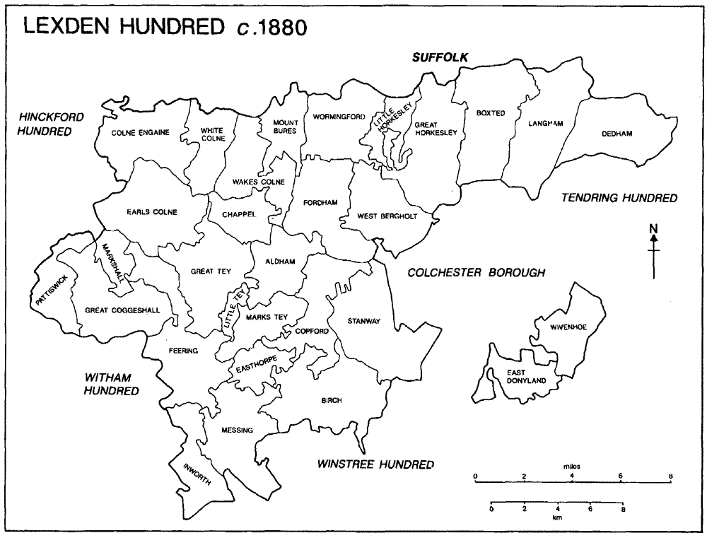
Lexden Hundred c. 1880
Matthew Mantell, sheriff of Essex from 1204, granted Lexden hundred to Ralph Gernon, a grant confirmed to Ralph and his heirs in 1207. (fn. 15) The hundred descended with Ralph's manors of Easthorpe and Birch until 1536 when Robert Peyton conveyed it to Sir Thomas Audley. (fn. 16) Audley devised it, with Berechurch, to his brother Thomas (d. 1572) and the hundred descended with Berechurch in the Audley and Smyth families until 1854 or later. (fn. 17) It was held for a fee farm rent of 4 marks from 1207 or earlier until the rent was remitted in 1537. (fn. 18)
The placename Lexden (Leaxa's valley) (fn. 19) presumably refers to the valley near Lexden church which may once have been the meeting-place of the hundred court. In 1262 John de Burgh, lord of Stanway and Lexden, had prevented the hundred from meeting in its usual place. (fn. 20) By 1581 the court was held at Stanway bridge, the bridge over Roman river between Stanway and Copford. (fn. 21) The hundred serjeant was recorded in 1198, the bailiff in 1254. (fn. 22) Late 16th-century courts seem to have been concerned almost exclusively with the collection of wardsilver and other dues, but the sheriff's tourn at Michaelmas 1574 ordered the scouring of ditches and the repair of a highway. (fn. 23) The site of the hundred pound in Birch still belonged to the owners of Berechurch in 1854. (fn. 24)
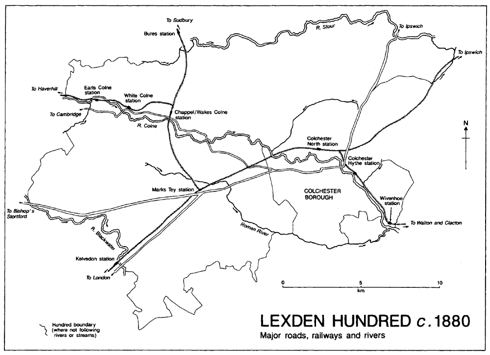
Lexden Hundred c. 1880
Major roads, railways and rivers
The only extensive liberty in the hundred was that of Westminster abbey in Feering; in 1274 the abbot claimed return of writs and all other royal liberties by grant of Henry III. Lawrence of St. Martin (fl. c. 1240) withdrew the manors of Great Fordham and Little Fordham (in Aldham) from the sheriff's tourn, and Robert de Quency (d. by 1264) similarly withdrew Wakes Colne manor. In 1274 Robert Fitz Walter in Great Tey, the earl of Oxford in Earls Colne, Baldwin Wake in Wakes Colne, Jordan de Sackville in Mount Bures, John de Burgh in Stanway, the abbot of Coggeshall in Coggeshall, John Neville in Langham, and Thomas of St. Martin in Little Fordham held view of frankpledge and the assizes of bread and of ale without the king's bailiff; the earl of Cornwall would not allow the royal escheators to enter his manors of West Bergholt and Mount Bures. Other lords held view of frankpledge and the assizes of bread and of ale in Great Birch, Colne Engaine, Copford, Fordham, and Marks Tey. (fn. 25) In 1574 only Aldham, Boxted, White Colne, Messing, Little Tey, Wivenhoe, and Wormingford attended the sheriff's tourn, and only Little Birch, Earls Colne, Dedham, Little Horkesley, Langham, and Markshall were said to have defaulted. The remaining vills had presumably been withdrawn. (fn. 26)
Like other Essex hundreds, Lexden had two chief constables in the later 16th century and the 17th. (fn. 27) By 1769 the hundred was divided into Colchester and Witham divisions. (fn. 28) All the parishes in the former Colchester division (West Bergholt, Birch, Boxted, Mount Bures, Dedham, East Donyland, Easthorpe, Fordham, Great and Little Horkesley, Langham, Stanway, Wivenhoe, and Wormingford), as well as Aldham, Chappel, Wakes Colne, Copford, and Great, Little, and Marks Tey, became part of the Lexden and Winstree Poor Law Union in 1834, and of the Lexden and Winstree Rural District in 1894. Wivenhoe became a separate Urban District in 1898. Earls Colne, Colne Engaine, and White Colne became part of the Halstead Poor Law Union in 1834 and of the Halstead Rural District in 1894. The remaining parishes in the hundred (except Pattiswick which became part of Braintree Poor Law Union) became part of Witham Poor Law Union and then of Braintree Rural District. (fn. 29) In 1974 Lexden and Winstree Rural District and Wivenhoe Urban District became part of Colchester Borough. Most of the parishes in Halstead and Witham Rural Districts, including Earls Colne, Colne Engaine, and White Colne, became part of Braintree District, but Messing and Inworth became part of Colchester Borough.
THE PRESENT VOLUME covers 21 parishes in the north and east of the hundred. Within that area, evidence of possible Mesolithic settlement has been found on the gravel terrace beside the river Colne in White Colne. Many later Neolithic finds have been made in the area, and there are Bronze-Age barrows and other possible early funerary monuments both along the Stour in Dedham, Mount Bures, and Wormingford, and further south, in White Colne and at Chitts Hill in West Bergholt. The fort at Pitchbury, in Great Horkesley, was first built in the early Iron Age. (fn. 30) In the mid to late Iron Age Camulodunum, which extended into the later Stanway parish, became the royal centre for much of Essex. It was succeeded by the Roman colony at Colchester. (fn. 31)
In the 11th century Mount Bures, Wormingford, and the Colnes were on the eastern edge of a large area of woodland which extended over much of north Essex. (fn. 32) In the 12th and 13th centuries land to the north and west of Colchester, in Dedham, Langham, Boxted, the Horkesleys, and West Bergholt, was within the woods and forests of Kingswood and Cestrewald. (fn. 33) Most of the wood was cleared in the Middle Ages, but Chalkney wood in Earls Colne survives with its medieval boundaries unchanged. Early medieval arable was probably organized into small common fields, but, in all the parishes except Dedham, holdings seem generally to have been consolidated and inclosed in the 12th and 13th centuries, if not earlier. Some of the field systems appear to have been shared by estates in two or more parishes, perhaps as a result of joint, early, clearance of woodland. Their inclosure left complicated boundaries and intermixed parishes which survived until the late 19th century, notably at Copford, Easthorpe, and Birch, and at Chappel, Wakes Colne, and Mount Bures. (fn. 34) Later assart land was presumably always held in closes. The resulting settlement pattern was one of scattered farmsteads, some of them moated, and hamlets, many of them grouped around small greens. Many roadside houses originated as 16th- and 17th-century encroachments, but others, particu- larly those on the London road in Stanway, are older. At Dedham the survival of an open-field system over much of the parish was probably associated with the development of a nucleated village. At Earls Colne the foundation of a market in 1250 presumably encouraged the growth of the settlement along the Colchester- Cambridge road. Wivenhoe and Rowhedge (in East Donyland) developed as ports for Colchester in the 16th century, and Wivenhoe was a small town by the 18th century. Hamlets grew up at bridges over the Colne in Aldham and Chappel. Elsewhere 19th- and 20th-century infilling has created new villages, many of which have become dormitories for Colchester and London. By the late 1990s the built-up area of Colchester extended into East Donyland, Stanway, and West Bergholt.
No one landowner dominated the area, and many of the smaller estates changed hands frequently. The de Veres, later earls of Oxford, held Earls Colne from the Norman Conquest, and the medieval earls were buried in the priory they had founded there. The earls acquired Crepping manor in Wakes Colne in 1356, Wivenhoe manor, by marriage, in 1425, Sherives manor in Colne Engaine before 1508, the priory manor in Earls Colne and Berwick Hall in White Colne at the Dissolution, and Wakes Colne manor in 1544. All were sold, to different pur- chasers, in the 1580s. The Ufford and de la Pole earls and dukes of Suffolk, lords of Stratford St. Mary (Suff.), held Dedham from 1338 and Langham from c. 1373 until the attainder of Edmund de la Pole in 1504. Robert Tey held land in Stanway by 1305; he acquired a moiety of Aldham Hall manor c. 1313, and his descendant, another Robert Tey, the other moiety in the later 14th century. A Robert Tey, probably a third man of that name, acquired Bart Hall in White Colne before 1325. St. John's abbey, Colchester, held the manors of East Donyland and Gosbecks in Stanway, as well as other, smaller estates in Stanway, West Bergholt, and Fordham.
Sir Harbottle Grimston acquired West Bergholt manor in 1641 and Wakes Colne manor and Wood Hall in Wormingford in 1646; his descendants sold Wakes Colne in 1719 and the other manors in 1775, but retained the advowson of Wakes Colne church until 1938. The Round family built up a large estate in Birch and Stanway from 1734, and acquired West Bergholt manor by marriage in 1829. John Hanbury of Coggeshall bought Mount Bures manor in 1750, and his son Osgood Hanbury obtained Inglesthorpes and Barts Hall manors in White Colne and Little Loveney Hall in Wakes Colne before 1768. Osgood's son, another Osgood, sold Mount Bures in 1790, but the other manors descended in the Hanbury family until the late 19th century.
Several Colchester men established themselves in the parishes around the town. George Sayer acquired Abbots in Stanway in 1546 and Bourchiers Hall in Aldham c. 1566. John Eldred held Olivers manor in Stanway by the earlier 17th century, and his son married one of the co-heiresses of Earls Colne manor. Isaac Lemyng Rebow acquired the later Wivenhoe Park in 1734; Jeremiah Daniell obtained an estate in West Bergholt in the earlier 18th century, and Thomas Moy bought Stanway Hall in the 1880s.
In the valleys of the Colne and the Stour and in some of the parishes around Colchester are a large number of timber-framed medieval houses. As elsewhere in Essex, the larger houses were built with an open hall and storeyed ends or cross wings, the small ones were single-storeyed. (fn. 35) On the whole only the larger houses survive, and what remains is often fragmentary and disguised by later work. Among the houses of manorial status are the early 14th-century Crepping Hall in Wakes Colne, (fn. 36) and the 15th-century or earlier Wenlocks in Langham, as well as Boxted Hall which preserves its early 14th-century hall and cross-wing plan, Olivers in Stanway, which has a possibly 14th-century north wing, Stanway Hall, where the early 15th-century roof survives, and Netherhall, Dedham, which has a cross wing of c. 1500. Other houses with open halls and storeyed ends or wings seem to have been farmhouses on copyholds or small freeholds. The earliest, Songers in Boxted, has a 13th-century, two-bayed, aisled hall. Parts of two aisled halls are incorporated into buildings on the High street in Earls Colne, a small town with several 14th- century fragments. Normandy Hall in Wakes Colne incorporates the aisled hall and cross wing of a 14th-century house. Other 14th-century work survives at Lane and Old House (fn. 37) Farms in the same parish and at Raynhams and the Swan inn, just across the Colne in Chappel. In the southern outskirts of the cloth-working town of Dedham, the earliest parts of Southfields (fn. 38) are 14th-century, but in the centre of the town there is only one 14th-century remnant; otherwise the earliest buildings are high quality, two-storeyed houses of the 15th century. The neigh- bouring parish of Langham, also a centre of cloth-working, contains at least twelve late medieval buildings; Glebe Farm, the former rectory house, is of the earlier 14th century, and Old House has a hall and cross wing of c. 1400. The possibly 13th-century barn at Langham Hall is the earliest surviving agricultural building in the area.
The hall and east wing of the White Hart inn and the hall and two cross wings at Beacon End Farm, (fn. 39) both in London Road, Stanway, are 14th-century, and at least four other houses along the road there date from the 15th century. In the neighbouring Copford, however, the earliest houses on the London road are 17th- century, and the only medieval building is the 14th-century cross wing at Mascotts Farm. On Horkesley Causeway, another main road out of Colchester, are at least five late medieval houses; four more lie near the Stour in Great and Little Horkesley. The five 15th-century houses in Aldham are all on the Colchester- Halstead road, but in the neighbouring Wakes Colne only one or two of the six or more late medieval houses are on that road. At Wivenhoe, south-east of Colchester and away from major roads, the earliest survival is the 15th-century hall and service end incorporated into a house in the High street.
The heaths in the north-eastern quarter of the hundred attracted settlement in the later Middle Ages. The core of Rye Farm, on the edge of the former Dedham heath, is 14th-century, and the nearby Winterfloods is only slightly later. The earliest surviving house at West Bergholt, High Trees Farm, which has an early 15th-century hall and cross wing, stood on the edge of the heath there. Wenlocks, Boxted, (fn. 40) was built c. 1500 on the edge of Boxted heath.
Halls and wings have conventional crown-post roofs, exceptions being the hall at Crepping Hall, Wakes Colne, which has base crucks, and a cross wing at Wash Farm, Fordham, which has a hybrid of the raised-aisle roof found in Norfolk and Suffolk. Construction shows the influence of Colchester and Suffolk building, the latter evident in the display of bold curved bracing. Open halls, often with ends in line, continued to be built in the 16th century, though, from the mid century, earlier halls were floored and chimney stacks inserted. At that time and in the 17th century chamber wings and hall ranges were rebuilt on a larger scale, as at Aldham Hall and Easthorpe Hall. (fn. 41) From the late 16th century, two-storeyed long-wall jettied houses began to appear in the centres of towns such as Earls Colne and Dedham; the Fox and Pheasant, at White Colne, is an isolated rural example. Some village and town buildings combined residential and industrial use, as did Southfields, Dedham, which was owned by a succession of clothiers, and Alberry's, Boxted. Southfields, Alberry's and Elms Hall Farm, Colne Engaine, had courtyard layouts entered through wide gateways. On a smaller scale, Flipses, Easthorpe, seems to have had a separate workshop bay. Unusual in building type and plan is Old Lodge Farm, Earls Colne, which incorporates a 15th-century park lodge.
Bakers Cottage at Langham was built in the early 16th century on a lobby- entrance plan. In the 17th century and the earlier 18th most houses had such plans, typified by that of Mayflower House, Colne Engaine. Timber-framed, usually two- storeyed, houses continued to be built in rural situations until the early 19th century. The Assembly Rooms at Dedham, built c. 1745, was the only public building so constructed.
Brick was used with stone and flint for building churches at Fordham, Great Horkesley, Mount Bures, and perhaps All Saints, Stanway, in the 14th century. By the late 15th and early 16th centuries brick was more widely used in church building, notably at the chantry chapel on Horkesley Causeway (fn. 42) and at Colne Engaine and Earls Colne churches; (fn. 43) at Dedham the brick was flint-faced. The precinct wall of Colne Priory is also of brick, which became widespread in domestic building from the early 16th century for chimney stacks. Brick was used most extensively in the early 16th-century rebuilding or recasing of Hoe Farm, Aldham, and for the hall at Birch Holt, work that has been demolished at both houses. A later 16th-century brick stair turret survives at Valley House, Langham. Sixteenth- century maps show that tiles and thatch were then used for roofing. Domestic brick building was not widespread until the 18th century. Newly-built or remod- elled manor houses, including the Little Horkesley Hall (c. 1700, later demolished), Copford Hall (refronted in 1720), Little Birch Hall (1727-8, later demolished), Colne Priory (c. 1736, remodelled 1825 and later), Wivenhoe Park (1759, re- modelled 1846-53), Langham Hall (after 1756), Colne Park (c. 1770, largely demol- ished) and West Bergholt Hall (1750s or 1760s) were of brick. At Dedham red and yellow brick was used in the 1730s for fronting town houses in sophisticated Baroque style. Lower down the social scale, in the mid 18th century the farmhouse at Nightingale Hall, Earls Colne, was extended and encased in brick, and later in the century a brick barn, (fn. 44) one of only three surviving in the county, was built there. Other houses were refronted or encased in brick in the later 18th century and the early 19th, when a refined classical style and gault brick became popular, as can be seen among the gentlemen's residences at Dedham. The Italianate Birch Hall and the Tudor Wivenhoe Park, (fn. 45) both designed by Thomas Hopper in the 1840s, and Colne Park as remodelled in the 19th century, (fn. 46) were the grandest and latest examples of such brick architecture. Brick predominated throughout the later 19th century and the 20th. More modest brick housing of the 19th century ranges from rows of workers' cottages at Chappel and small villas at Colne Engaine to estate housing built by the Rounds at Birch. The 20th century has added the Tollgate shopping centre at Stanway (fn. 47) to the range of building types.
The commercial dominance of Colchester ensured that Lexden hundred remained almost entirely rural into the 20th century. The only successful market town was Coggeshall, on the western edge of the hundred and outside the scope of the present volume. It was probably the largest and wealthiest settlement in the hundred in 1327, by far the largest in 1801 and, although it had not grown much during the intervening century, it was still just more populous than the growing port and Colchester suburb of Wivenhoe in 1901. In 1524 and 1525, however, Coggeshall was surpassed by the developing market and cloth town of Dedham, which was otherwise second to it until the mid 19th century. (fn. 48) The other medieval market, at Earls Colne, failed in the 15th century, perhaps because of competition from the neighbouring market at Halstead. There is evidence for clothworkers in Dedham in the 13th century, and at Langham, Earls Colne, and Colne Engaine in the 14th. The industry, probably dependent on that of Colchester and Halstead, flourished in the later 16th century and the earlier 17th when it was carried on in most of the parishes along the Stour as well as in the Colnes and in Chappel. It died out in the mid 18th century, although some spinning continued until c. 1800.
In the later 19th century falling agricultural wages were augmented by outwork for Colchester clothing factories in the parishes around the town, by straw-plaiting in the north of the hundred, and by tambour lace-making in the parishes around Coggeshall. Only the clothing work continued into the 20th century, and in the 1930s unemployment caused concern in many parishes. (fn. 49) At Wivenhoe shipbuild- ing started in the 16th century and throve from the late 17th to the 20th centuries; in East Donyland it started in the 1760s and grew into a major industry in the early and mid 20th century. In the mid and later 19th century the Hunt family built up a large engineering works at Earls Colne which continued until 1988, and the Daniell family built up a successful brewing business at West Bergholt. In the later 20th century gravel extraction, hitherto small-scale, consumed large areas of Stanway. During the Second World War airfields were built at Earls Colne, Langham, Birch, Fordham, and Wormingford. In the 1970s and 1980s industrial estates were established on those at Earls Colne, Langham, and Wormingford.
The medieval parks at Earls Colne, Langham, and Wivenhoe (the latter extending into Elmstead) were disparked and converted to arable in the 16th cent- ury; that at Great Horkesley was probably disparked about the same time, but its nucleus survived as a country estate into the 19th century. In the 18th century the Rebows at Wivenhoe and the Hills at Colne Engaine created landscaped parks, and the Harrisons at Copford and the Rounds at Birch laid out extensive gardens. (fn. 50) Elsewhere a pattern of small, irregular, fields, with a few small woods or plan- tations, continued into the mid 20th century. Most farmers concentrated on arable farming, with some livestock, but in the agricultural depression of the late 19th century and the early 20th some diversified into seed- or fruit-growing or poultry rearing. Farmers from elsewhere in Britain, many from Scotland, moved into the area in the earlier 20th century. Since the Second World War, intensive, mechan- ized, arable farming on larger farms has resulted in the amalgamation of fields and the destruction of hedges. (fn. 51) Encouraged by European Union subsidies, many late 20th-century farmers planted oilseed rape and linseed, whose distinctive colours have altered the appearance of the countryside in spring and early summer.