A History of the County of Middlesex: Volume 7, Acton, Chiswick, Ealing and Brentford, West Twyford, Willesden. Originally published by Victoria County History, London, 1982.
This free content was digitised by double rekeying. All rights reserved.
'Chiswick: Communications', in A History of the County of Middlesex: Volume 7, Acton, Chiswick, Ealing and Brentford, West Twyford, Willesden, (London, 1982) pp. 51-54. British History Online https://www.british-history.ac.uk/vch/middx/vol7/pp51-54 [accessed 12 April 2024]
COMMUNICATIONS.
Two Roman roads from London crossed the north part of the parish and converged near Brentford. (fn. 1) The northern one, from Newgate, having crossed Hammersmith along the line of Goldhawk Road, continued west to form the northern boundary of Chiswick. Along the eastern part of that boundary there was no road in 1746, although short sections were later marked by Bath Road and Chiswick Road. Farther west Chiswick High Road, passing through Gunnersbury and curving towards the river, may represent the northern road. The southern Roman road, Akeman Street, left London along the Strand and passed through Kensington and Hammersmith to Turnham Green, where originally it may have headed westsouth-west, skirting the southern edge of the common and continuing along the line of Wellesley Road. By the late 17th century the main east-west route was that of the later high road, (fn. 2) which followed the southerly Roman road to Turnham Green and thence cut due west across the common to Gunnersbury. Still known simply as the high road or Brentford Road in the 18th century, when it was turnpiked, (fn. 3) it was placed under the metropolitan turnpike roads commissioners in 1826 as the 'great western road', a description which was later to apply to a new route farther south. (fn. 4) From the late 19th century it has been called Chiswick High Road. (fn. 5)
A minor east-west route crossed the peninsular part of the parish, linking Old Chiswick with Strand-on-the-Green. (fn. 6) In 1728 it had no name (fn. 7) and by 1832 it was called Burlington Lane. (fn. 8) Shorter lanes ran southward from the high road to Old Chiswick in 1746: corresponding to the existing British Grove, Chiswick Lane, and Devonshire Road, they led respectively to the east end of the riverside road called Chiswick Mall, to its centre, and to Church Street at its west end. (fn. 9) British Grove was so called by the 1860s, as was the southern part of Devonshire Road, previously Chiswick Field Lane; Chiswick Lane, the most direct and presumably the oldest way to the village, was so called in 1747. (fn. 10) Hogarth Lane, so called by 1832, (fn. 11) led northwestward from Old Chiswick and apparently was a road in 1746; (fn. 12) although providing a short cut to Turnham Green common, it had become no more than a footpath across the duke of Devonshire's land by 1800. (fn. 13) From the high road the main northward route in the 18th century was Acton Lane, at the western end of Turnham Green common, although there were several paths to the Back common. From Turnham Green a lane also ran southward to Little Sutton, where it described a westerly loop before continuing south from the medieval manor house to join the western end of Burlington Lane; it was called Little Sutton Lane until the 1860s and Sutton Lane by 1890. (fn. 14) Strand-on-the-Green could be reached from the east along Burlington Lane or from the west by a short approach from the high road to the Kew ferry. A lane, perhaps afterwards Brook Road, in 1746 connected the later Wellesley Road with the middle of Back Lane, which ran behind the line of riverside houses (fn. 15) and c. 1908 was renamed Thames Road. (fn. 16)
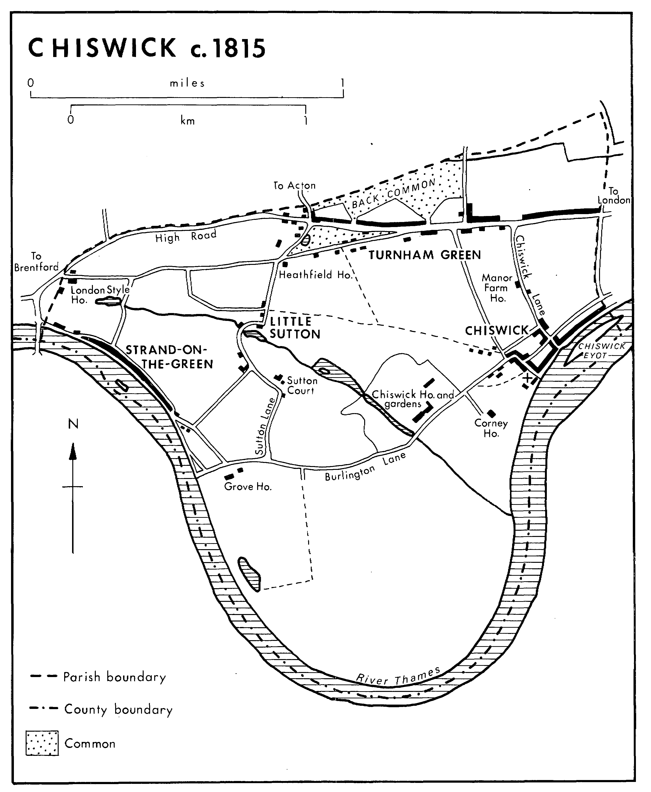
CHISWICK c.1815
The only significant changes between the mid 18th and mid 19th centuries were made in the 1820s by the duke of Devonshire. West of Chiswick Lane, and parallel with it, a carriage drive was constructed from the high road to Hogarth Lane, where it passed through the northern entrance gates of Chiswick House, and by the 1860s was called Duke's Avenue. On the other side of Chiswick House, Burlington Lane was moved farther south. (fn. 17) There were still no public roads in the central part of the parish, where the duke's parkland lay, and only tracks leading to fields south of Burlington Lane.
Apart from the addition of Sutton Court Road, which ran south from Turnham Green to Burlington Lane by 1886, (fn. 18) the main thoroughfares remained the same until after the First World War. In 1923 Chiswick U.D.C. bought 200 a. of riverside land from the duke of Devonshire as part of its plan to open up the southern tip of the parish for recreation. By 1925 a 2,000-ft. long embankment and terraced promenade lined the loop of the river, opposite Barnes, and sports grounds were under construction, (fn. 19) soon to be reached by Promenade Approach Road and Riverside Drive.
The first of several modern arterial roads, dividing one part of Chiswick from another, was planned in 1914 to improve the south-western outlet from London. Traffic was to be diverted from Chiswick High Road down Chiswick Lane to Mawson Lane, behind Old Chiswick, and thence along part of Burlington Lane to Great Chertsey Road, cut diagonally across the peninsula to the new Chiswick bridge west of Mortlake (Surr.). Work began in 1922 on a bridge over the railway south of Burlington Lane but it was not until c. 1930 that the eastern end of the lane itself was widened to form part of Great Chertsey Road (fn. 20) and not until 1933 that the bridge over the Thames was ready. Meanwhile part of the Great West Road, opened in 1925, (fn. 21) was formed from Hogarth Lane and the suburban avenues to the west as far as a new roundabout in Chiswick High Road, whence it continued across Brentford.
Another phase of road building for longdistance traffic began in 1955 with the widening and straightening of the Great West Road as part of the Cromwell Road extension. Roundabouts were built at the intersections with Devonshire Road and Sutton Court Road; (fn. 22) the names of Mawson Lane, Hogarth Lane, and its western continuations thereafter applied merely to stretches of the main road; the avenues which it crossed were bisected and later given the suffixes 'North' and 'South', (fn. 23) many being turned into cul-de-sacs and some linked by pedestrian subways, first opened in 1956. (fn. 24) From 1959 the Great West Road was carried over the roundabout near the western end of Chiswick High Road by a flyover (fn. 25) and from 1964 Chiswick flyover was linked with an elevated section of the M4 motorway. (fn. 26)
Bollo brook in 1826 passed under the high road at the west end of Turnham Green common, where a small culvert sometimes overflowed. The stream from the grounds of Chiswick House in 1746 apparently passed under Burlington Lane and in 1826 was confined to a width of 10 ft. beneath a brick bridge recently built by the duke of Devonshire. (fn. 27) Foot ferries at Old Chiswick and Kew were mentioned in 1659 (fn. 28) and presumably had long been in use, since there were no medieval bridges over the Thames in Middlesex. (fn. 29) Kew ferry grew busier after Kew became a royal residence, William III being among those who probably took short cuts to the high road along Sutton Lane from Strand-on-the-Green, (fn. 30) and more traffic followed the opening of a bridge in 1759. (fn. 31) There was no other bridge nearer than Fulham in 1826, however, (fn. 32) and Chiswick ferry was still used in the 1890s. (fn. 33) Apart from the approaches to Kew bridge, on the boundary, Great Chertsey Road became the only road across the Thames from Chiswick parish, with the opening in 1933 of the 700-ft. long Chiswick bridge, designed by Sir Herbert Baker and faced with Portland stone. (fn. 34)
A coach made two return journeys daily from Turnham Green to London in 1825 (fn. 35) and coaches, some of them presumably stopping only in the high road en route, left every half hour by 1832. (fn. 36) Eleven omnibuses ran between Turnham Green and the Bank in 1838-9, eight of them operated from the George IV inn by George Cloud, who also operated four from Kew bridge. (fn. 37) By 1845 omnibuses left for London every quarter hour. (fn. 38)
The West Metropolitan Tramways Co., which already ran horse cars from Shepherd's Bush to Acton, in 1882 opened a route from Shepherd's Bush along Goldhawk Road to Young's Corner at the east end of Chiswick High Road. Thence horse cars ran westward along the high road to Kew bridge from 1882 and eastward to Hammersmith Broadway from 1883. Services were poor by 1894, when the West Metropolitan, whose main depot lay north of Chiswick High Road, was taken over by the new London United Tramways Co. Electric trams were introduced by the L.U.T. on the enlargement of the depot and the opening of a power station in 1901. (fn. 39)
Lack of public transport in the areas away from Chiswick High Road led to rival but abortive proposals for new routes by the L.U.T., the county council, and Chiswick U.D.C. between 1900 and 1902. Trolleybus powers were conferred on the U.D.C. by an Act of 1911, to take effect from 1913, but were not exercised, (fn. 40) the first trolleybuses arriving only in 1935 (fn. 41) and surviving until 1962. (fn. 42) Motor buses operated by the London General Omnibus Co. reached Chiswick in 1911 (fn. 43) and, as part of London Transport's network, later served most parts of the parish.
The first railway reached Chiswick from Surrey, cutting diagonally across the empty southern part of the parish. A branch of the London & South Western Railway Co.'s line from Waterloo to Richmond, it crossed the Thames by Barnes bridge and ran northwestward through Chiswick and Kew Bridge stations to Brentford and Hounslow. Chiswick station, designed by William Tite and opened in 1849, was renamed Chiswick and Grove Park in 1872 and Chiswick again in 1920. (fn. 44) Not until 1869 did the L.S.W.R. open a line from Kensington through Hammersmith to Turnham Green (fn. 45) and Brentford Road. South of Brentford Road station, renamed Gunnersbury in 1871, the line divided: part of it was connected by a westward curve to the old line north of Strand-on-theGreen, while part ran south across the Thames to Kew Gardens and Richmond. At Hammersmith the station of the L.S.W.R. was close to that of the Hammersmith & City Railway Co., whence trains ran to central London. The populous northern part of the parish was also served from 1877 by the Metropolitan District Railway Co. from the City, which used the L.S.W.R.'s track from Hammersmith to Richmond, and by the Metropolitan. In 1879 the Metropolitan District, known simply as the 'District', opened a branch from Turnham Green to Ealing Broadway, with a station just across the parish boundary called Acton Green, renamed Chiswick Park and Acton Green in 1887 and Chiswick Park in 1910. (fn. 46) Early trains for workmen were provided by the L.S.W.R. and the District by 1890. (fn. 47) The District electrified its service in 1905 and opened Stamford Brook station, on the Chiswick side of the Hammersmith boundary, in 1912, after the track through Turnham Green had been widened. (fn. 48) In 1923 the L.S.W.R. was absorbed by the Southern Railway (fn. 49) and in 1933 the District's lines passed to the London Passenger Transport Board, thereafter forming part of London's Underground system. (fn. 50)