A History of the County of Somerset: Volume 6, Andersfield, Cannington, and North Petherton Hundreds (Bridgwater and Neighbouring Parishes). Originally published by Victoria County History, London, 1992.
This free content was digitised by double rekeying. All rights reserved.
'Lyng', in A History of the County of Somerset: Volume 6, Andersfield, Cannington, and North Petherton Hundreds (Bridgwater and Neighbouring Parishes), (London, 1992) pp. 53-56. British History Online https://www.british-history.ac.uk/vch/som/vol6/pp53-56 [accessed 20 April 2024]
LYNG
The ancient parish of Lyng included a Saxon burh now occupied by East Lyng village, the 'island' of Athelney with its Alfredian monastic foundation and stronghold, and the detached settlement of Burrow, a possible defensive outpost of Athelney abbey. (fn. 1) The name Lyng derives from the Old English hlenc, meaning a hill; Athelney means 'the island of the princes'. (fn. 2)
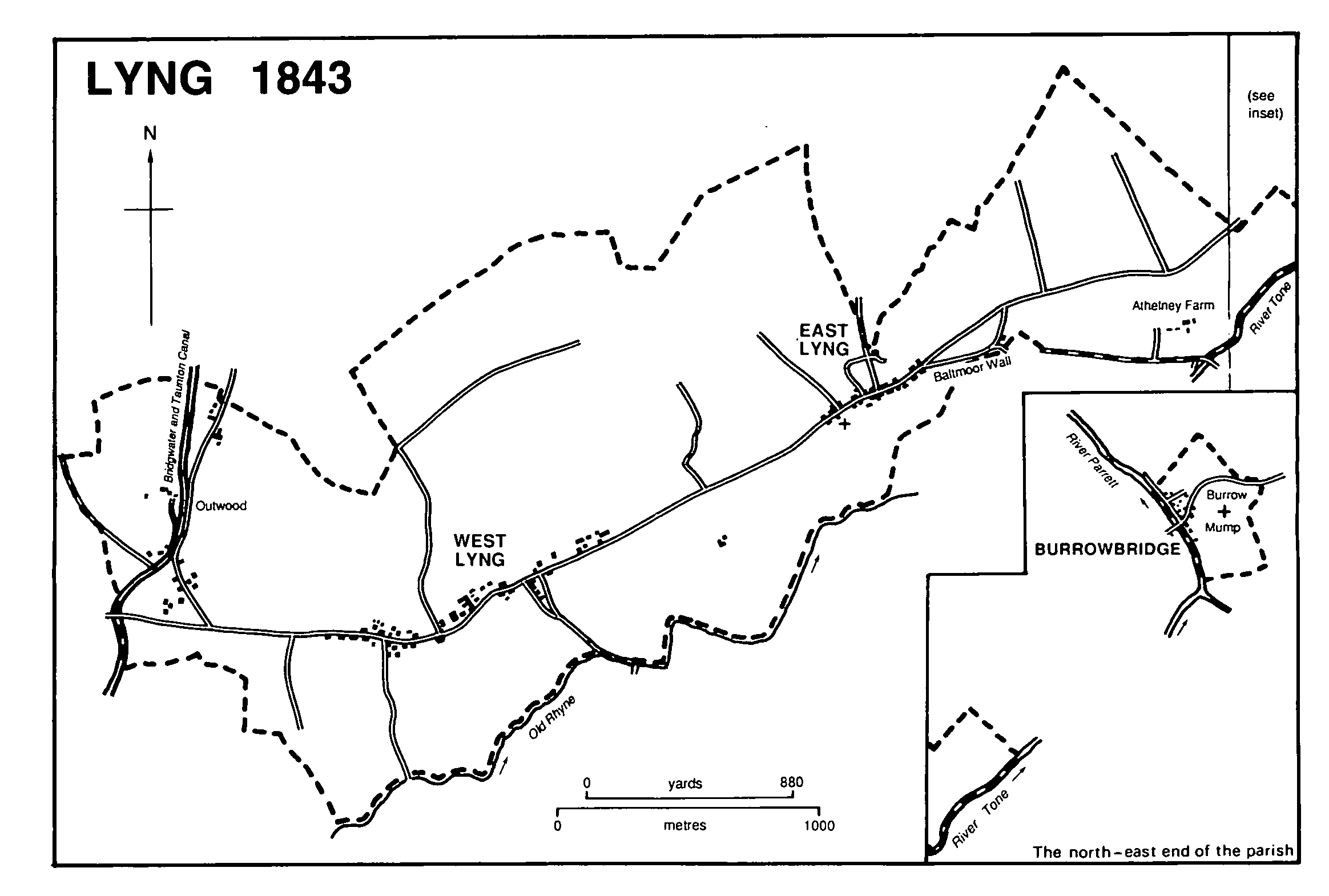
The parish occupies a ridge c. 3 km. long which protrudes north-eastwards as an extension of the Quantocks into the moors of the Parrett basin between North Petherton to the north and North Curry and Stoke St. Gregory to the south. East from the end of the Lyng ridge and attached to it by a causeway lies Athelney hill, where Athelney abbey stood east of the Alfredian fortress. (fn. 3) The monument to Alfred on the eastern end of the hill was erected by John Slade in 1801. (fn. 4) Just over 1 km. further north-east on the east bank of the Parrett and formerly a detached part of Lyng parish is Burrow, named after Burrow Mump or Mount, (fn. 5) a rocky outcrop forming a flat-topped hill with a ruined chapel on its summit. (fn. 6) The hamlet below the hill, formerly known as Burrow, was called Burrowbridge by the early 19th century after the bridge there. (fn. 7) A smaller detached part of the parish, lying 0.5 km. north-west of Burrow on the west bank of the Parrett in Salt moor (fn. 8) and including 2 houses and 8 persons, was in 1885 transferred to Stoke St. Gregory. In 1886 Burrowbridge (14 a., 8 houses, and 44 persons) was transferred to Othery. In 1882 uninhabited parts of North moor, including a large triangular area north of East Lyng village, had been transferred to Lyng parish from North Petherton, and a detached part of Lyng parish had been added to North Petherton; in 1888 Priestwood, formerly in Durston parish, was also added to Lyng. (fn. 9) In 1981 the parish measured 592 ha. (1,463 a.). (fn. 10)
The ridge which forms the thin spine of the parish is made up of Keuper marl with two pockets of valley gravel. (fn. 11) At its western end, where clay was dug in the 19th century for brickmaking, (fn. 12) the ridge reaches just over 30 m. in height and is nearly 1 km. wide; further east it falls and narrows, and beyond East Lyng village it ends abruptly at the 7-m. contour. Burrow Mump, also of Keuper marl, reaches 31 m.
The boundary described in the perambulation of Lyng attached to a charter of 937 has not been identified on the ground, but does not seem to coincide with the later parish boundary. (fn. 13) The southern boundary is now in part the Old Rhyne, the eastern end of which is probably the former course of the West Yeo, (fn. 14) that branch of the Tone which flowed between East Lyng and Athelney. The boundary further east follows the Baltmoor wall built c. 1154 presumably to prevent flooding in Higher Salt moor to the north. (fn. 15) The wall was faced in stone in 1675. (fn. 16) The boundary with North Petherton in the north, agreed c. 1204, (fn. 17) follows man-made watercourses in North moor. Burrow was bounded on the west by the Parrett and on the north and east by the former course of the river Cary. (fn. 18)
Settlement has been confined since earliest times to those areas above the flood plain. Two bronze palstaves and a Roman bronze mask were found on Athelney island, and several sherds of Romano-British pottery were discovered at the foot of Burrow Mump. (fn. 19) Permanent settlement was established in the later 9th century. In 878 King Alfred built a stronghold on Athelney island when it was still 'surrounded on all sides by very great swampy and impassable marshes', (fn. 20) the fortress probably sited at its western end. To complement that fortress, another was later built, probably before 893, at the eastern end of the Lyng ridge, the two joined across the river then flowing between them by a bridge 'made with laborious skill'. The second fortress, 'very strong' and 'of most beautiful workmanship', has been convincingly identified as the compact settlement of East Lyng, where traces of a defensive bank and ditch west of the village coincide with reasonable accuracy with the dimensions of a burh listed in the Burghal Hidage. (fn. 21) At the eastern end of Athelney island King Alfred established a monastery c. 888, possibly in succession to a hermitage. (fn. 22) The monastery, possibly refounded c. 960 after destruction in Danish raids, was dissolved in 1539. (fn. 23)
The charter of 937 described the estate west of the 'town', an estate later known as West Lyng manor. (fn. 24) By the 17th century four settlements were named in the main part of the parish: East Lyng (so called by 1334), (fn. 25) Middleton, and West Lyng all lay along the crest of the ridge, and Outwood in the north-western end of the parish, a scatter of cottages around a green. (fn. 26) Outwood may be the 'Prostrat' Lenge' mentioned in 1497, (fn. 27) the name either suggesting desertion or referring to its site on ground falling towards North moor and the Durston stream. East and West Lyng in the 20th century were the main settlements, on the Taunton-Wells road, the latter (probably including Middleton) a group of regularly spaced farmhouses, the former school, and local-authority and private houses nearly all on the north side of the road. Outwood expanded with the building of the Bridgwater and Taunton canal and later of the railway and with the exploitation of the brick field. (fn. 28) Tenements below Burrow Mump were referred to in the early 16th century, (fn. 29) and later included at least two inns in Lyng parish. (fn. 30)
Lyng 1843
The Taunton-Wells road keeps to the crest of the ridge and forms the main route through the parish. Its course until the early 19th century, turnpiked by the Taunton trust from 1752 to 1875, passed through West and East Lyng and then ran along the Baltmoor wall south of Athelney Farm to cross the Tone at Athelney Bridge. (fn. 31) A new road was built between 1803 and 1806 across Salt moor from the eastern end of East Lyng village direct to Burrowbridge. (fn. 32) Improved alignment there involved a new tollgate in 1804-5 and a tollhouse c. 1805. (fn. 33)
From the central spine, roads or lanes lead north and south into the droves of the moors. At Outwood a lane to Hedging in North Petherton was cut by the Bridgwater and Taunton canal, and was replaced by a footpath beside the later brickfields. (fn. 34) Further east Hitchings Drove leads north into the moors of West Lyng. A field lane south from Lyng Court Farm to Curry moor was established by 1427 (fn. 35) and was later known as Streaked or Streaky Lane. (fn. 36) A second southward route from West Lyng to North Curry was planned in 1829 but was not made until c. 1869. (fn. 37) The north side of East Lyng village is an irregular rectangle formed by lanes, but only one lane, formerly called the Lane or Lyng Drove Lane, survived in use in 1985 and has recently been called Hector's Lane. (fn. 38) It leads to the former demesne lands of Athelney abbey beside Lyng Drove in an area known as Culer or Cular. (fn. 39)
The bridge over the Parrett at Burrow consisted until the earlier 19th century of three high arches with cutwaters. (fn. 40) It was replaced in 1826 by a wider bridge slightly to the north, designed by P. B. Ilett of Taunton. (fn. 41) Tolls, let annually by sand-glass auction, were charged until 1945. (fn. 42) New Bridge, rebuilt c. 1876, takes the road over the old course of the river Cary NNE. of Burrow Mump. (fn. 43) Athelney bridge, where the former turnpike crossed the Tone south-east of Athelney island, was a two-arched wooden structure in 1791. (fn. 44) The present bridge is of concrete. There was a wharf at Athelney bridge in the 18th century (fn. 45) and another at Burrowbridge until the mid 19th. (fn. 46)
The Bridgwater and Taunton canal, cut through the western edge of the parish at Outwood, was opened in 1827. It ceased to be used commercially after 1892. (fn. 47) The BridgwaterTaunton section of the Bristol and Exeter railway, on a roughly parallel course, was opened in 1842. A branch line from Yeovil entered the parish south of East Lyng village, and at its junction with the main line Durston Junction station was opened in 1853. A loop line avoiding the junction was built further south in 1906 joining the main line at Cogload junction in Durston. (fn. 48) Durston Junction station and the original branch line were closed in 1964. (fn. 49)
There is no evidence of open-field arable in the parish. The grasslands to the north and northwest of the Lyng ridge were recovered during the Middle Ages from North moor and Higher Salt moor. (fn. 50) There were 50 a. of woodland on the estate in 1086, (fn. 51) some of which may have been on the northern moor land where timber trunks are still discovered under the pastures. (fn. 52) The name Outwood, used by 1543, may represent part of the former woodland including the adjoining Priestwood in Durston. By 1543 there were two areas of wood, Walbarough wood (7 a.) and Conygath copse (6 a.), (fn. 53) the latter perhaps recalling the grant of free warren made to the abbot of Athelney c. 1136-9. (fn. 54) The inclosed parts of the parish were said c. 1791 to be 'very woody', but by 1905 woodland had been reduced to less than 2 a. (fn. 55)
Later 17th-century inventories refer to several houses of two and three-roomed plan, one having a two-storeyed hall with a chamber and buttery 'within' it. (fn. 56) Two cottages at Outwood, Half Thatch and Outwood Cottage, remain relatively unaltered from that period. Modernization in 1912 obliterated the three-roomed plan of Council Farm, West Lyng. (fn. 57) Church Farm, East Lyng, remains of traditional plan. A number of substantial houses, including Winchester House, were built in brick in East Lyng village early in the 19th century, (fn. 58) and further building took place there in the 1980s.
There were two tipplers in the parish in 1619. (fn. 59) A victualler was licensed in 1630 and another in 1660, two in 1657 and 1674, and three in 1675-6. One of the victuallers in 1657 was at Burrow, where in 1686 the inn had 8 beds and stabling for 16 horses. (fn. 60) By 1708 an inn called the Anchor or Burrow inn was established at Burrow. By 1797 it was known as the Bell and by 1806 as the King Alfred. The building was modified to accommodate the new turnpike road in that year, and was still in business in 1985. (fn. 61) The Lyng inn at East Lyng was so named by 1709 and was renamed the Rose and Crown by 1786. It was in business in 1985 and occupies a building dating from c. 1600. (fn. 62) In the mid 18th century there was a third victualler in the parish and in the 1830s two other inns, the White Hart at East Lyng and the King John (possibly later the Bell) at Burrow. (fn. 63) There were beer houses at Outwood and West Lyng in 1851 and a beer retailer at Burrowbridge by 1875. (fn. 64) The Railway Hotel was established at Durston Junction by 1861 (fn. 65) and was in business as an inn in 1985.
In 1563 there were 53 households attached to the parish church and 12 to the chapel at Burrow. (fn. 66) About 1791 there were 22 houses at West Lyng, 16 at East Lyng, 8 at Outwood, and 18 at Burrow, with a total of c. 340 inhabitants. (fn. 67) In 1801 the total was 253. From that date there was a continuous increase until 1851 (the 1841 figure including 40 men working on the railway), and only a small decrease by 1861. Thereafter a slow decline brought the total in 1901 to 327. (fn. 68) By 1911 the number had fallen to 285 but from that date it remained roughly stable; between 1971 and 1981 the total rose to 315. (fn. 69)
The bridge at Burrow was recognized as of strategic importance during the Civil War, and a fort was built, presumably on the hill above. It was taken from the royalists after the battle of Langport in 1645. (fn. 70) In 1685 Lord Feversham secured the Parrett crossing shortly before the battle of Sedgemoor. (fn. 71)
St. Ethelwin, brother of King Cenwealh, may have been a hermit on Athelney island. (fn. 72) The 'fen fastnesses' there were the refuge of King Alfred in the winter of 877-8 before the battle of Edington. (fn. 73) George Marston (1882-1940), artist and explorer, member of Sir Ernest Shackleton's two expeditions to the Antarctic 1907-9, 1914-16, and co-author and co-illustrator of Antarctic Days (1913), was buried in the parish. (fn. 74)