An Inventory of the Historical Monuments in the County of Northamptonshire, Volume 3, Archaeological Sites in North-West Northamptonshire. Originally published by Her Majesty's Stationery Office, London, 1981.
This free content was digitised by double rekeying. All rights reserved.
'Daventry', in An Inventory of the Historical Monuments in the County of Northamptonshire, Volume 3, Archaeological Sites in North-West Northamptonshire, (London, 1981) pp. 62-72. British History Online https://www.british-history.ac.uk/rchme/northants/vol3/pp62-72 [accessed 26 April 2024]
In this section
23 DAVENTRY
(OS 1: 10000a SP 56 NE, b SP 56 SE)
The modern parish, covering about 1700 hectares, comprises the medieval parishes of Daventry and Drayton, the latter now a suburb of the town. Most of the area consists of undulating Jurassic clayland sloping generally N.E. between 210 m. and 110 m. above OD and drained by a series of small N.E.-flowing streams. In the N.W. of the parish the clays are overlaid by glacial clay, sands and gravel.
Along the E. side lies the great irregular flat-topped block of Borough Hill, rising to 200 m. above OD and capped by Northampton Sand. Its summit is ringed by a hill fort (3) which is by far the largest in the county and one of the largest in England. Despite the fact that its defences, except on the N., are negligible, finds from the area indicated a long period of occupation through much of the prehistoric and Roman periods and later. It is likely that it was the immediate predecessor of the Roman town of Bannaventa (Norton (4)) which lies to the E. The other monument of note in the parish is the enclosure known as Burnt Walls (35), which lies to the S. of Borough Hill; not only is it of unusual form, but also of unknown date and function.
b(1)–(21) Borough Hill complex (Fig. 54; Plate 1). Borough Hill is a large, roughly triangular hill covering more than 200 hectares in the E. part of Daventry parish. It is mainly of Lower Lias Clay, but is capped by Northampton Sand which gives it a rounded summit below which are steep clay-covered slopes. The highest point, almost 200 m. above OD, is near the S. end. The base of the whole hill is at about 145 m. above OD.
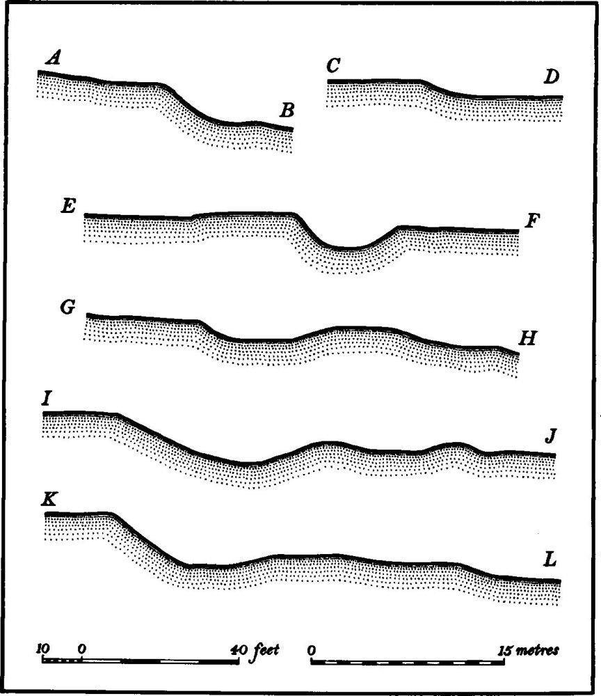
Daventry (3) Borough Hill Profiles (see Fig. 54)
The site is one of the most important in the county, because of both the variety and the historical implications of the remains. Chance finds indicate occupation during much of the later prehistoric period, culminating in the great hill fort itself. The latter seems to be of two distinct phases, a large but slightly defended contour fort, succeeded by a massively protected but much smaller fort at the N. end of the hill. During the Roman period there seems to have been much occupation here and the known remains include a large villa and a number of burial mounds.
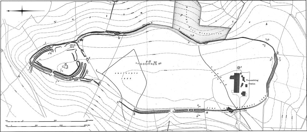
Fig. 54 Daventry (1–21) Borough Hill Complex
Two or perhaps three Saxon burials are recorded from the hill and, unusually, some Viking weapons. In the 10th century the hill fort is called a burh in a Saxon Charter (BCS 792; 944 AD) but elsewhere in the same charter it is also termed the stod-fald perhaps indicating that it was used for livestock at that time (PN Northants., 10–12). For most of the medieval period the hill was apparently pasture for the township of Daventry. In 1645 at least part of the Royalist army encamped there immediately before the Battle of Naseby. By the early 18th century the hill was used as a race course, races being held annually up to 1741 and then infrequently until 1801. At that date the archaeological remains were probably still well preserved, but since then a continuous process of destruction and mutilation has affected the site.
After the enclosure of the parish in 1801 the hill was divided into fields and much of the summit was ploughed. A farm was then built on the N. end of it, large parts of the hill fort defences were damaged or destroyed, and the barrows ploughed over. In the 1930s the site became a large BBC transmitting station; destruction and disturbance, still continue. Recently a golf course has been made across the N. part of the hill, resulting in further damage. As a consequence of this modern activity archaeological knowledge is fragmentary. Two separate excavations in the 19th century, first by Baker in 1823 and then by Botfield in 1852, produced much valuable evidence though by modern standards the methods used were totally inadequate. Further work in the early 1920s also led to valuable discoveries.
The literature is extensive. The main sources are: J. Morton, Nat. Hist. of Northants. (1712), 519–20, 546–7; J. Bridges, Hist. of Northants., I (1791), 42; G. Baker, Hist. of Northants., I (1822–30), 339–47; JBAA, I (1846), 245; C. Roach Smith, Coll. Antiq., I (1848), 113; Archaeologia, 35 (1853), 383–95; W. Edgar, Borough Hill and its History (1923). This latter work includes a collection of almost all the early commentaries on the area by Camden, Walpole, Brayley and Pennant.
Many of the finds from the hill are in NM and BM, but an important collection made by Edgar is situated in Daventry School (hereafter DS). This collection has been examined by A. E. Brown whose catalogue, including detailed descriptions and drawings, is deposited in NM and NMR.
The finds and the monuments on Borough Hill are here listed together for convenience.
Prehistoric and Roman
At least two Palaeolithic implements have been discovered on the hill. One is a small twisted ovate of developed middle Acheulean type (NM: PPS, 29 (1963), 382–3; Edgar, op. cit., Plate 4). The other, a small pointed hand axe, was found in 1932 during the construction of the BBC transmitting station and thus must have come from SP 588621 (DS).
In 1932 Edgar made a 'representative collection of flint implements' from within the hill fort. These include leaf-shaped and tanged arrowheads, circular and oval scrapers and notched flakes as well as cores and waste flakes (DS). Two Neolithic axes are also recorded (both in DS), one of chipped flint and the other, incomplete, of polished greenish-grey stone. The latter came from the foundation trenches of the BBC transmitting station (SP 588621).
Bronze Age discoveries include three looped palstaves. One was found before 1893 (lost; NM Records) and the two others (DS) are labelled 'from Borough Hill Camp'. Two socketed axes (DS) were found together in 1932 at the BBC transmitting station with the broken stone axe noted above, and part of a bronze sword-blade in the school's collection is also labelled 'from Borough Hill Camp'.
Further Bronze Age and Iron Age objects recorded as 'from Daventry' (see p. 67) may have come from the hill fort. Among other unlocated finds from the hill are two coins, of Gallienus and Julian, a 'metal kettle' and quantities of teeth and bones (letter dated 23 March 1865, in Dryden Collection, Central Library, Northampton).
(1) Barrow (SP 58896210; Fig. 54), E. of the BBC transmitting station on ground sloping gently E. at 195 m. above OD. In 1830 Baker (op. cit., 347) said that it was the most prominent 'tumulus' on Borough Hill. By 1932 Edgar (op. cit., 37) noted that it was 'visible but inconspicuous'. No trace now remains.
(2) Barrow (SP 58946306; Fig. 54), immediately S. of the northern fort on almost level ground at 190 m. above OD. It consists of a small roughly circular mound some 10 m. in diam. and 0.25 m. high, much mutilated, with no trace of a ditch. It was excavated by Baker in 1823 after it had already been ploughed (Baker, op. cit., 347). He discovered a primary cremation accompanied by fragments of a large urn 'ornamented below the rim with a zig-zag pattern', possibly a Collared Urn, as well as fragments of at least two or three other urns and a 'small part of a patera of light-red ware'. The latter may have been Roman and thus a secondary feature. Certainly a secondary inhumation with animal bones was also found. Baker records that two or three years before his work a broken jet amulet had been picked up on the surface of the barrow.
(3) Hill fort (centred SP 588626; Fig. 54; Plate 1), known as Borough Hill Camp, can be assigned to two separate periods. At the N. end of the hill is a small roughly triangular fort bounded by a massive bank and ditch but the whole hill top is surrounded by a much smaller bank and ditch. The relationship between the two defence systems has never been clear and most authorities have assumed that the northern fort was earlier and that the contour fort was added later. However, as the present survey indicates, it is more likely that the outer contour fort was the earlier defence and that the main northern fort was a later addition. This conclusion is the same as that reached by Edgar in 1923 (op. cit., 30–31). If this is so then the contour fort may be interpreted as a pre-Iron Age fortification of a type recently identified elsewhere. The late Bronze Age finds both definitely or possibly from the interior of the fort (see above) might support this idea.
The Contour Fort covers an area of some 54 hectares and was once probably bounded by a number of banks and ditches. However as a result of later destruction the original defences do not survive in their original state anywhere. In the S.W. these defences ('a' on plan) have been entirely flattened and no trace exists on the ground. Even in the early 19th century this section had probably almost disappeared, as a result of ploughing, though Baker's map of 1822 (Baker, op. cit., 343) showed the defences still existing. By 1923 Edgar (op. cit., Fig. 1; 29) noted that the 'old line of the defences can yet be seen under favourable circumstances'. Further N. the defences are still partly preserved for a distance of 400 m. ('a'–'b' on plan). Here, though the inner bank is reduced to little more than a scarp, the ditch is in good condition, being 1.25 m. deep with the counterscarp bank 1 m. high. Near the S. end of this section the ditch is blocked by two causeways of unknown, but perhaps recent, date. Neither of these was shown on Edgar's plan of 1923 (Edgar, op. cit., Fig. 1). A little to the N. of the causeways the line of the defence system is broken for a short distance at the head of a small spring. No earthworks existed here in 1923 according to Edgar though Baker in 1823 showed the line of defences unbroken at this point.
Beyond this the ditch and the counterscarp bank reappear and continue for some 210 m., after which only the downhill side of the counterscarp bank, a scarp 1 m. high, is visible ('b'–'c' on plan). For the next 150 m. no trace of the defences remains. Again Baker's map of 1823 showed the defences complete here, though Edgar's map indicated nothing.
At the edge of the golf course ('d' on plan) the outer side of the inner bank or rampart, now mutilated by a golf tee, is again visible, with, after a small break, the other face of the counterscarp bank below it. There is no indication of a ditch at this point. A little further N. these defences have been altered by the later defences of the northern fort, which at this point ('e' on plan) sweep N.W. and behind the contour fort's counterscarp bank.
From here to the N. corner of the hill ('e'–'f' on plan) all that remains of the earlier fort is a rounded bank, nowhere more than 1 m. high, which appears to be the counterscarp bank. The original ditch and inner bank or rampart have apparently been destroyed by the later ditch of the northern fort. These features are not shown on either Baker's or Edgar's maps.
At the N. end of the hill ('f' on plan) the counterscarp bank and indeed the defences of the northern fort are cut by a deeply hollowed trackway climbing the hill from the N.W.; it is not depicted on Baker's map of 1823 and Edgar described it as modern in 1923. Beyond this hollow-way are two short lengths of scarp; another further downhill (not shown on plan) is modern. The former appear to be the outer faces of the rampart and of the counterscarp bank of the contour fort, but there is no trace of the intermediate ditch. From this point, for some 330 m. along the E. side of the hill ('f'–'g' on plan), nothing remains of the contour fort defences apart from the well-marked scarp 2 m. high following the existing hedge-line, which probably represents the position of the original rampart. A slight ledge or scarp (not shown on plan) to the E. below the hedge, along this section and further S., is not part of the fort but is a natural feature occuring at the junction between the Northampton Sand and the underlying Lias Clay.
In the S.E. corner of the golf course ('g' on plan) the main contour fort scarp is broken and after a short gap reappears inside the line of the modern hedge, still as a scarp 1 m.–2 m. high. Below it, on the hedge-line, are traces of a much smaller scarp surmounted in places by the hedge-bank. This is probably all that remains of the original counterscarp bank. By 1823 Baker indicated that the defences here were already in this condition, but just over a century earlier in 1712, Morton (op. cit., 520) said that they consisted of 'two deep trenches and three banks'.
Further S. again ('h' on plan) a later terrace-way or track cuts across both scarps and, a short distance beyond, the upper scarp fades out. For the next 160 m. ('h'–'i' on plan) only the lower scarp remains, up to 2 m. high. There is then a short gap where even this scarp has been destroyed, after which it reappears, only 0.5 m. high, for some 40 m. ('j' on plan). In 1712 Morton described the defences here as consisting of 'three trenches and four banks'. Today there is then another gap beyond which the scarp reappears and can be followed as far as the S.E. corner of the hill ('j'–'k' on plan). Along the N. part of this section the scarp is 2 m.–3 m. high, but further S., as it curves across the S.E. corner of the hill, it has been reduced by ploughing and other activities to little more than 0.25 m. high. In 1823 Baker described a similar situation but in 1712 Morton said that the defences comprised two ditches and three banks.
In the S.E. corner of the fort ('k' on plan) the defences reappear in a state somewhat near their original form, and run N.W. for 270 m. Here they consist of a low flat-topped rampart 0.25 m.–0.5 m. high above the interior, with a steep-sided ditch in front of it, cut 2.25 m. deep below the top of the rampart and 1.25 m. below the ground surface to the S. There is no trace of a counterscarp bank. However here also much modern destruction seems to have occurred for Morton in 1712 recorded two ditches and three banks, perhaps implying that there was at least another ditch with a bank on each side of it beyond the present ditch. The face of the surviving rampart is now in poor condition and has partly collapsed to reveal that it was constructed of Northampton Sand. Towards the W. end of this section the ditch disappears and the rampart fades out; beyond, all trace of the defences is lost. In 1971, during excavation for new radio masts and cables on this southern section (SP 588619), part of a ditch was exposed. This showed that the original ditch was dug to a depth of 3 m. and later recut after some silting. After more silting it seems to have been recut again to a depth of 2.25 m. with a much narrower profile. It was then abandoned. No finds were made (DOE Arch. Excavations 1971, (1972), 11–12). Similar evidence was noted in 1918 when a trial trench for ironstone was dug here. Then Edgar and T. J. George noted that the ditch was silted up at least 1.2 m.–1.5 m. (4 ft.–5 ft.) deep (Edgar, op. cit., 29).
Apart from the barrows (1, 2, 4–17) and the chance finds listed above little is recorded from the interior. Baker's map (op. cit., 343) shows a large roughly rectangular earthwork near the W. side, S. of the northern fort (centred at SP 588628). Baker (op. cit., 344) described it as having a slight bank inside a ditch. In its S.W. corner and S. side met the W. rampart of the contour fort, but the N. side, Baker claimed, passed through the defences and extended down the hill as a 'covered way'. By 1923 all but the N. corner of this enclosure had gone (Edgar, op. cit., 32) and this N. corner survives now only as a scarp 0.2 m. high; however, another scarp continues N.E. for some 45 m. before turning S.E. and fading out. Baker also marked what he called a 'small trench' crossing the S. part of the hill but no trace remains. It was almost certainly an old hollow-way.
During work for new radio masts in 1971 (DOE Arch. Excavations 1971, op. cit.) two features were noted immediately N. of the S. defences of the contour fort. One was a round-bottomed pit or ditch with no evidence of silting and no finds. The other was a pit, at least 1.25 m. deep and 1 m. wide, with vertical sides. It was perhaps originally a storage pit, but may later have been used in an iron-making process. One sherd, possibly of early Iron Age date, was found in it. Morton (op. cit., 521) records the discovery of 'Roman money' in a cut through the ramparts though exactly where is not specified.
The Northern Fort covers just under 5 hectares and consists of a roughly triangular area, bounded by a massive rampart, a ditch and a counterscarp bank on the E. and W. sides. On the S. side a rampart, ditch and counterscarp bank, possibly with an outer and later bank and ditch beyond, cut across the hill top. The W. side is the best preserved. Here the inner rampart is no more than a scarp falling into the main ditch, except at the N. end where slight traces of the inner side of the bank, only 0.25 m. high, remain. The ditch is steep-sided and flat-bottomed, cut 3 m. below the summit of the rampart and 1.5 m. below the counterscarp bank on the outside. The counterscarp bank is much damaged and in places is only a low scarp 1 m. high. Elsewhere it is a bank of similar height. At the extreme N. corner of the fort ('f' on plan) a later, deeply hollowed trackway has cut across the ditch and apparently continues within the fort ditch along the N.E. side where it is 3 m. deep below the interior of the fort though no inner rampart is visible. Beyond the ditch the counterscarp bank still exists 1 m. high. After some 140 m. the latter fades out, the hollow-way ends and the inner side of the ditch turns W. to form an entrance-like feature before continuing S. in a mutilated form for another 40 m. This possible entrance is marked on Baker's map of 1823 as is the continuation of the scarp to the S. Baker also showed the counterscarp bank as still existing below it.
The S.E. corner of the fort and the E. part of its S. defences no longer exist. The earthworks were almost entirely destroyed by the farm built here in the early 19th century and now demolished. Some of the remaining scarps can be interpreted as the sites of farm buildings, and a deep pit to the W. is also to be connected with the farm. In 1823 the main rampart which had undoubtedly existed here had already gone, according to Baker's map, though what appears to be a broad ditch with another bank and ditch beyond it is depicted. To the W. again ('l' on plan) the S. defences are mainly intact and consist of an inner rampart, now reduced to a scarp, and a deep ditch, 4 m. below the rampart and 2 m. below the outer counterscarp bank, the latter here only 0.25 m. high. Below and some 10 m.–15 m. in front of the counterscarp bank is another bank 0.2 m. high with traces of an outer ditch up to 2 m. deep at its W. end. The position and appearance of this outer bank and ditch may indicated that it is a later addition to the defences on this side in order to strengthen the weakest side of the fort. At their E. ends this outer bank, the counterscarp bank and the main ditch all fade out, and the inner rampart curves inwards to form an ovoid flat-topped mound some 2 m. high. This suggests that before destruction there was some form of inturned entrance to the fort at this point. In 1823 Baker dug into the ovoid mound on the assumption that it was a barrow, as shown on his plan (Baker, op. cit., 343). In it he found 'part of a skeleton of a man, the tooth of a horse and several other bones', near the surface. Apart from the Roman Villa (18), the Saxon burials (19–21) and Viking finds (see below) no other discoveries are recorded from the interior of this northern fort (RAF VAP CPE/UK/1994, 2267–8).
(4)–(17) Roman Barrows (SP 589626; Fig. 54), lay on the summit of the hill at 195 m. above OD. In the early 18th century, Morton (op. cit., 520) wrote that there were 18 'tumuli' in a N.–S. row, with small depressions in their summits. Baker (op. cit., 346–7) noted that some were dug into, without any recorded results, around 1800. By 1823 only 14 remained and all had been ploughed over. In that year Baker trenched all the main barrows. His map shows all the 14, 11 of which were in a roughly N.–S. line, with three more to the E. It is not possible to identify these exactly with his descriptions of the excavation though he appears to have numbered them from N. to S. No trace of them remains on the ground today.
(4) Barrow (SP 58916276), Baker's (1), at the N. end of the group, described as very slight. Nothing was found in it and Baker doubted if it was a barrow.
(5) Barrow (SP 58916275), Baker's (2), immediately S. of (4), described as very slight. Nothing was found in it and again Baker doubted if it was a barrow.
(6) Barrow (SP 58916273), Baker's (3), immediately S. of (5). Baker discovered charcoal and bones and a cist with a covering stone.
(7) Barrow (SP 58916271), Baker's (4), immediately S. of (6). Baker found nothing.
(8) Barrow (SP 58916269), Baker's (5), immediately S. of (7), and in 1823 the 'most prominent' of the group with a diameter of 9.8 m. (32 ft) and nearly 1.5 m. (5 ft.) high. It covered an area of black earth and was probably constructed of stone but it had been dug into earlier.
(9) Barrow (SP 58916268), Baker's (6), immediately S. of (8). It was constructed of earth and covered four separate burials, all cremations contained in urns and three with other vessels near them. Baker described this as a 'family barrow'. All the pottery survives (in NM and DS).
(10) Barrow (SP 58916266), Baker's (7), immediately S. of (9). Baker described it as 'doubtful or had been previously examined'.
(11) Barrow ((?) SP 58916265), Baker's (8), probably immediately S. of (10), and one of the most 'conspicuous'. It consisted of a cairn of stones 0.6 m. (2 ft.) thick, below which was a layer of dark earth almost 0.3 m. (1 ft.) thick. This covered a circular area 1.2 m. (4 ft.) in diam. paved with small stones on which were spread burnt ashes and bones mixed with red earth and charcoal. At its E. end was a 'rude buckle of brass' as well as a considerable quantity of the same metal, much corroded.
(12) Barrow ((?) SP 58916263), Baker's (9), at least 1 m. (3 ft. 6 in.) high, covering a floor of burnt earth, charcoal, and bones, presenting 'the appearance rather of the spot where the body was burnt than of the actual place of interment'.
(13)–(15) Barrows ((?) SP 58926264), Baker's (10), (11) and (12) probably lay to the E. of (11). All 'furnished traces of the rites of cremation, but nothing of particular detail'.
(16) Barrow ((?) SP 58916261), Baker's (13), probably immediately S. of (12), at least 0.6 m. (2 ft.) high. It contained a small urn covered with five 'rude stones of the neighbourhood'. On the E. side of the urn was a considerable amount of burnt earth and charcoal which Baker suggested was the 'place of cremation'. The urn survives (in NM).
(17) Barrow ((?) SP 58916260), Baker's (14), probably S. of (16), only 0.3 m. (1 ft.) high. Below the mound and dug about 1 m. (3 ft. 6 in.) into the original ground surface was a circular stoned-lined cist, 1 m. (3 ft. 6 in.) in diam. In it was a small urn, containing a cremation burial, associated with a small handled vessel and a samian dish. These three items survive (in NM). Near by were corroded nails and fragments of iron.
All the surviving pottery, eleven complete pots, can be assigned to individual barrows (Northants. Archaeol., 12 (1977), 185–190; Edgar, op. cit., Plates 12 and 13). It all appears to be Roman, 2nd-century in date. In addition there is a small Roman bronze cooking pot of the 'Eastland' type (DS; Jahrbuch des Romisch-Germanischen Zentralmuseum, Mainz, 13 (1966), 67–164) which was not mentioned in Baker's account of the barrows but was included by Edgar (op. cit., Plate 12) in the pottery from the excavation.
(18) Roman villa (SP 58896320; Figs. 54 and 55), near the S.W. corner of the northern fort on a small knoll at 191 m. above OD. It was first excavated by Baker in 1823 (op. cit., 344–6) and then by Botfield in 1852 (Archaeologia, 35 (1853), 383–95).
Botfield re-excavated the area Baker had dug and then extended the work to reveal other parts of the building, but only a small part of the complete villa was exposed and little can be concluded from the plan made at the time (Fig. 55). The excavation uncovered a large range of rooms orientated N.–S., the S. part of which was a bath suite.
The building was constructed of sandstone rubble and there was ample evidence of tiled roofs. Many of the walls were decorated with painted plaster and a number of mosaic pavements, mostly in a very fragmentary condition, were discovered. One of the latter was virtually complete and was removed, but only a small fragment now survives (NM; Edgar, op. cit., Plate 1; C. Roach Smith, Coll. Antiq., 1 (1848), 113). There was clear evidence that the building was not all of one date, and both Baker and Botfield noted that one of the rooms had been adapted to form a corridor. Botfield also claimed that the most northerly room appeared to be a later addition to the rest.
The numerous finds (Edgar, op. cit., Plates 15–20 and 27–34) included large quantities of pottery of early 2nd to 4th-century date. Some of this was of Nene valley type and there was also some samian ware. Among other objects either recorded or surviving were a marble moulding (NM; Northants. Archaeol., 13 (1978), 85), miscellaneous ironwork such as an axe, keys, knives, buckles and part of a fibula, some pieces of bronze largely unidentifiable but including a razor and a bracelet (BM), tesserae, hypocaust tiles, flue and roof tiles, painted wall-plaster, a lead weight, a gaming object, two stone spindle whorls, part of a glass bottle, fragments of window glass, coal and pieces of antler. There are also at least 18 surviving coins (DS) mostly of late 3rd to mid 4th-century date.
Botfield's excavations also included the discovery of a stone-lined well immediately S.W. of the building, which contained, in its upper levels, a skeleton with bronze 'accoutrements' as well as an iron fibula and a hook. To the S. of the villa, at the rear of the S. rampart of the northern fort, Baker found a length of wall running roughly parallel to the rampart. Beyond was a deposit of burnt earth, charred wood, a knife and a socket of a spear, bones of horses, cows, sheep, deer and pigs and a large quantity of Roman pottery. The wall may have been the boundary of the villa complex with a rubbish dump outside it.
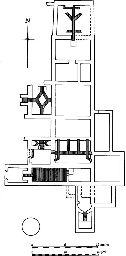
Fig. 55 Daventry (18) Roman villa (based on excavator's plan, 1852)
No trace of the villa remains on the ground and only a disturbed area marks its position.
For the Saxon burial from this site, see (20) below.
Medieval and Later
Two Viking battle-axes of Wheeler's type V1, dating from the later 10th or 11th century (Edgar, op. cit., Plate 8; J. Northants. Natur. Hist. Soc. and FC, 25 (1931–2), 177–8) and two spearheads (Edgar, op. cit., Plate 9) are all said to have been found during the cutting of a road on the N. side of Borough Hill around 1850. However it is possible that the spearheads are in fact those recorded as being associated with two of the Saxon burials listed below (20) and (21) and which cannot otherwise be traced.
(19) Saxon burial (unlocated), said to be from one of the numerous barrows on Borough Hill which Baker excavated in 1823, although Baker himself does not mention any such finds (Edgar, op. cit., Plate 14; VCH Northants., I (1902), 255). An inhumation burial, probably secondary in the barrow, was accompanied by a square-headed small-long brooch, a bronze buckle with a stylized dolphin's head on one plate, a bronze pin, a bronze boss, beads of glass, paste and amber, and two bronze Roman coins, both pierced for use as pendants and one certainly of the 4th century. It has been suggested that the burial is 5th-century (Meaney, Gazetteer, 186–7; J. Northants. Mus. and Art Gall., 6 (1969), 44–6).
(20) Saxon burial (SP 58896320), found in one of the rooms of the Roman villa (18) by Botfield (op. cit., 384) in 1852. A skeleton, lying N.–S. with a small spearhead at its side, was discovered within one of the rooms of the bath block. The spearhead may be one of those illustrated by Edgar (op. cit., Plate 8; now in DS) and said by him to have been found with the Viking axes noted above.
(21) Saxon burial (?) (SP 58946335), found at the northern end of Borough Hill a few years before 1823. A skeleton of a man in a stone cist with a spearhead by his side was dug up (Baker, op. cit., 347).
Undated
Baker (op. cit., 344) said that lynchets 'and other peculiarities' existed on the W. side of Borough Hill. Apart from the ridge-and-furrow on the lower slopes in this area (34), the only features which survive are uneven scarps and banks (at SP 585622). These are of purely natural origin, being land-slips of the underlying Lias Clay.
DAVENTRY PARISH (excluding Borough Hill)
Prehistoric and Roman
The following finds are recorded only as 'from Daventry' but some or all of them may have come from Borough Hill: two bronze palstaves (BM; VCH Northants., I (1902), 143; NM; T. J. George, Arch. Survey of Northants. (1904), 13; Plate 22); a bronze Hallstatt boat-shaped brooch (DS) of Italian type, probably dating from the 6th or 7th century BC; an Iron Age gold coin, a quarter stater of the North of Thames Group (Mack 271), said to be in NM but not recorded there (S. S. Frere (ed.), Problems of the Iron Age in Southern Britain (1958), 187).
The supposed long barrow, recorded by Baker (Hist. of Northants, I (1822–30), 340) at the E. end of Daventry Wood Hill (around SP 580610) was probably either part of the deer park pale (33) or part of the moated site of John Gaunt's Castle (32).
Edgar (Borough Hill and its History (1923), 38) said that a 'tumulus existed in Daventry until quite recently; its site is now occupied by the Council Schools' (SP 573626). As this location is very close to the old town centre the survival of a barrow here is unlikely.
Roman material, including 3rd-century pottery, horse bones and oyster shells, was found during road construction in 1968 S. of Drayton village (SP 565623). However it is probable that the material was brought from elsewhere when old quarries were filled in during the 19th century (BNFAS, 3 (1969), 1).
Baker recorded Roman bricks and tiles found on the 'opposite side of the road to Burnt Walls' (about SP 581611; Baker op. cit., 339). This material may have been medieval in date and connected with John of Gaunt's Castle (32) though several Roman coins are also said to have come from here (Whellan, Dir., 398).
a(22) Roman settlement (?) (SP 566651), in the N. of the parish on Boulder Clay at 140 m. above OD. Roman pottery and worked flints have been found (Northants. Archaeol., 8 (1973), 26).
b(23) Roman settlement (?) (SP 564649), S.W. of (22) on Boulder Clay at 145 m. above OD. Roman pottery and worked flints are recorded (Northants. Archaeol., 8 (1973), 26).
b(24) Roman settlement (?) (SP 554630), in the W. of the parish on Middle Lias Clay at 160 m. above OD. Roman pottery and worked flints have been found here (Northants. Archaeol., 8 (1973), 26).
b(25) Roman settlement (?) (SP 554622), 800 m. S. of (24) near the W. parish boundary, on Marlstone Rock at 155 m. above OD. Roman pottery and worked flints have been recorded at this site (Northants. Archaeol., 9 (1974), 89).
b(26) Roman settlement (?) (SP 557618), in the S.W. part of the parish on Marlstone Rock at 165 m. above OD. Roman pottery and worked flints have been recorded (Northants. Archaeol., 9 (1974), 89).
b(27) Roman settlement (?) (SP 58166280), E. of Daventry, at the foot of Borough Hill, on Upper Lias Clay at 145 m. above OD. Roman pottery, including Nene Valley wares, and floor and roof tiles were discovered here in 1965 (NM Records). Medieval pottery was also found on the site.
Medieval and Later
For medieval pottery at SP 58166280 see (27) above. Other medieval finds (in DS) include two glazed floor tiles from 'Rectory Park', an iron spur and a Nuremberg token.
b(28) Medieval quarries and post-medieval pits (SP 57486255), on the S. side of Daventry High Street. Development of the area in 1973 revealed a number of deep quarry-pits filled with loose stones and containing a few fragments of 14th-century Potterspury roof tile. Sherds of 13th and 14th-century pottery, a number of post-medieval pits and ditches, and walls of 19th-century property boundaries were also discovered (Northants. Archaeol., 9 (1974), 104–5).
b(29) Medieval building (?) (SP 57486255), lay immediately E. of Daventry church. During redevelopment in 1974 part of a stone wall cut into by later cellars was noted. A 13th-century pot of green-glazed ware was found near by (Northants. Archaeol., 10 (1975), 166).
b(30) Fishponds (centred SP 578623; Fig. 56), now entirely destroyed by building developments and playing fields, lay in the valley of a small N.E.-flowing stream immediately S.E. of the old town centre of Daventry on Middle Lias Clay at about 135 m. above OD. The only indication of their form comes from OS records and air photographs (RAF VAP CPE/UK/1994, 2269–70) on which Fig. 56 is based. Nothing is known of their history, but they are probably to be associated with the Cluniac Priory of Daventry. The priory was founded around 1090 at Preston Capes and moved to Daventry in 1107–8. It was situated immediately to the W. of Daventry church, at the E. end of the High Street (VCH Northants., II (1906), 109–13).
The fishponds consisted of four roughly rectangular ponds cut down into the valley bottom and separated by dams. No dimensions are known except that one of the dams ('a' on plan) was 1.6 m. high and that the scarp along the S.W. side of the upper pond ('b' on plan) was 1 m. high. The original stream through the valley was diverted to pass along the S. and S.E. sides of the ponds.
b(31) Settlement remains (SP 566625), formerly part of the village of Drayton, lie immediately S. of the old village on a N.-facing slope on Middle Lias Clay at 150 m. above OD. A series of embanked closes extend S. from the existing houses and probably represent former gardens.
b(32) Moated site (SP 581612; Fig. 57), known as John of Gaunt's Castle, lay in the S.E. corner of the parish within the deer park (33) on almost flat ground at the base of a steep slope, on Upper Lias Clay at 15 m. above OD. It was probably a medieval moated hunting-lodge, but little is known of its history.
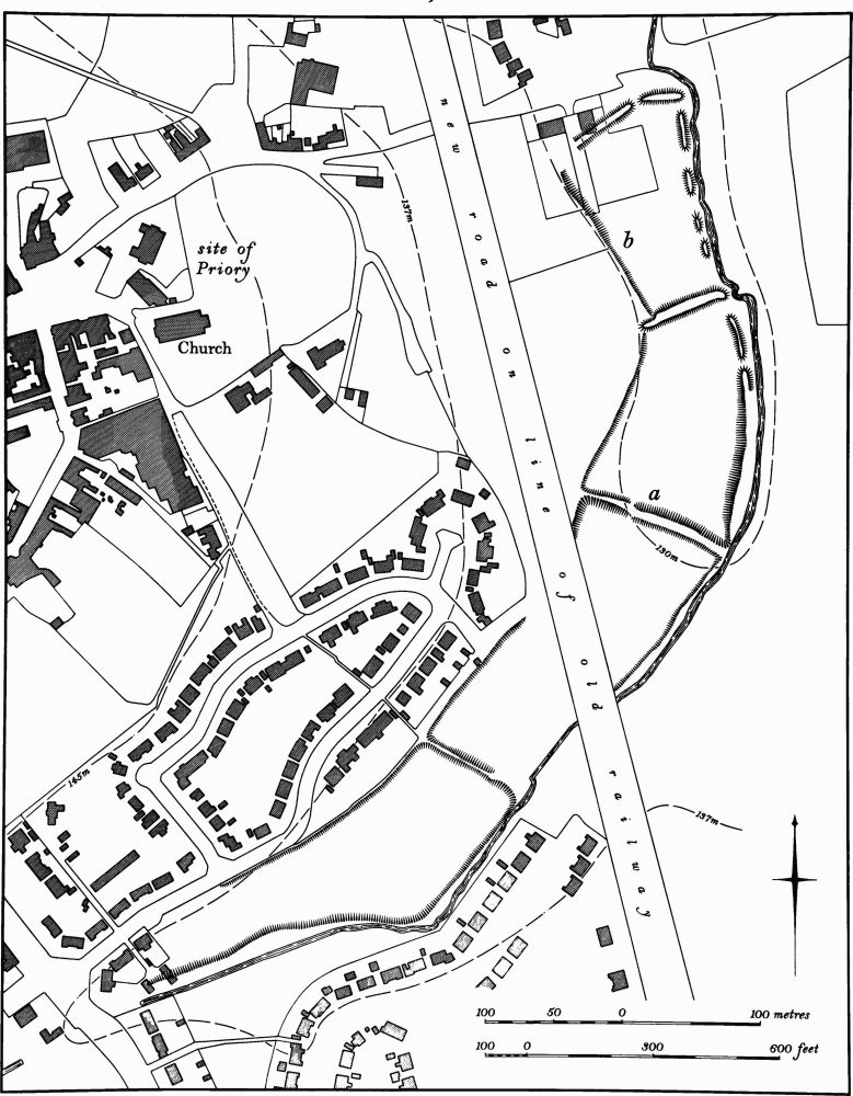
Fig. 56 Daventry (30) Fishponds
There are various records of Roman bricks and tiles having been found on the site; this may be a mis- identification of medieval materials. In 1816 the wood which then covered the area was removed and a 'double ditch was disclosed within which, just below the surface, was the foundation wall, varying from 4 ft. to 5 ft. in thickness, of a rectangular building 40 yards long and intersected with three cross walls' (G. Baker, Hist. of Northants., I (1822–30), 339).
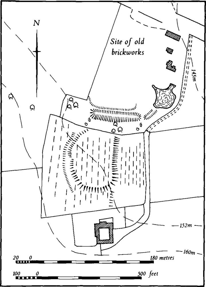
Fig. 57 Daventry (32) Moated site known as John of Gaunt's Castle
The N. part of the site, including all but the S. side of the moat, was worked for clay for a brickyard from at least 1857 until 1904 and during this time massive foundation walls were exposed and then destroyed. A building, apparently the one described by Baker, is recorded and described as 'square' and occupying an area of about one third of an acre with 'three cross walls'. On the S.W. side the foundations of a detached round tower 8 m. in diam. were discovered and traces of another, similar one were noted on the E. side. Foundations of 'an entrance which had evidently been approached by a drawbridge' were found there apparently on the S.E. of the building (W. Edgar, Borough Hill and its History (1923), 49–51; Northants. N. and Q., 5 (1921–3), 212–3). Recently the whole site has been built over except for the S. side of the moat which remains as a long ditch 1.2 m. deep. In the field to the S. is a small roughly D-shaped enclosure, bounded by a low scarp 0.5 m. high, with traces of an outer ditch on its W. side; this enclosure has been completely overploughed in ridge-and-furrow. There are slight indications that there was once a further enclosure to the S. again. A medieval glazed roof tile, said to be from the site, survives (DS), but a stone mortar of the 14th or 15th-century date and found in about 1853 on the site is lost (BNFAS, 3 (1969), 1; Northants. Archaeol., 8 (1973), 26; J. Morton, Nat. Hist. of Northants. (1712), 519).
b(33) Deer park (centred SP 580610), lies in the extreme S.E. of the parish, against the Newnham parish boundary. It occupies some 25 hectares of land on Upper Lias Clay, N.E. of Newnham Hill and mainly in a broad open combe facing N.E.
The park is first recorded in documents in 1284 when it belonged to Robert Fitz Walter (G. Baker, Hist. of Northants., 1 (1822–30), 311). Bridges (Hist. of Northants., I (1791), 43) said that it was 'formerly enclosed by a stone wall ... long demolished'. The area appears always to have been woodland and was known as Daventry Wood or The Wood (NRO, Enclosure Map, 1803) until 1816 when all the trees were removed (Baker, op. cit., 339). Within the park, near its N. side, stood John of Gaunt's Castle (32) with which it was presumably associated.
Very little remains of the park boundary although its outline is clearly defined by the parish boundary on the S. and E., by the A45 road on the N. and by a continuous hedge-line on the W. However what may have been its original boundary wall is recorded by Edgar (Borough Hill and its History (1923), 50–1); when discussing the finds from John of Gaunt's Castle, discovered during the 19th century clay-digging, he mentions the fact that a 'boundary wall was found near the highway'. No trace now exists along the N. side, as road-widening and modern buildings have destroyed any former remains. Along the W. side only a modern hedge bank is visible. However along the N. and W. sides, just inside the parish boundary, is a spread bank up to 5 m. wide but only 0.25 m. high. This may be the original boundary.
(34) Cultivation remains. The common fields of the old parish of Daventry were enclosed by an Act of Parliament of 1802 (NRO, Enclosure Map, 1803; Pre-Enclosure Map, 1802). Immediately before that date there were three open fields lying to the N., E. and S. of the town, known as Bean, Barley and Wheat Field respectively.
Ridge-and-furrow of these fields survives on the ground or can be traced on air photographs taken before modern urban expansion destroyed it over large areas. It was arranged in end-on and interlocked furlongs, mainly laid out across the contours although near the foot of the N.W. corner of Borough Hill (SP 586633) are two end-on furlongs of ridge-and-furrow which, unusually, lie skewed across the contours on a steep slope. These lay in Norton Road Furlong and Under Thrup Leys Furlong in 1802.
The common fields of the parish of Drayton were enclosed by an Act of Parliament of 1752, but no map apparently survives. Ridge-and-furrow of these fields remains on the ground or can be traced on air photographs over much of the area. It is best preserved in the N.W. of the parish where almost the total pattern of furlongs is recoverable in both end-on and interlocked blocks (RAF VAP CPE/UK/1994, 2267–73, 4271–7, 4355–9).
Undated
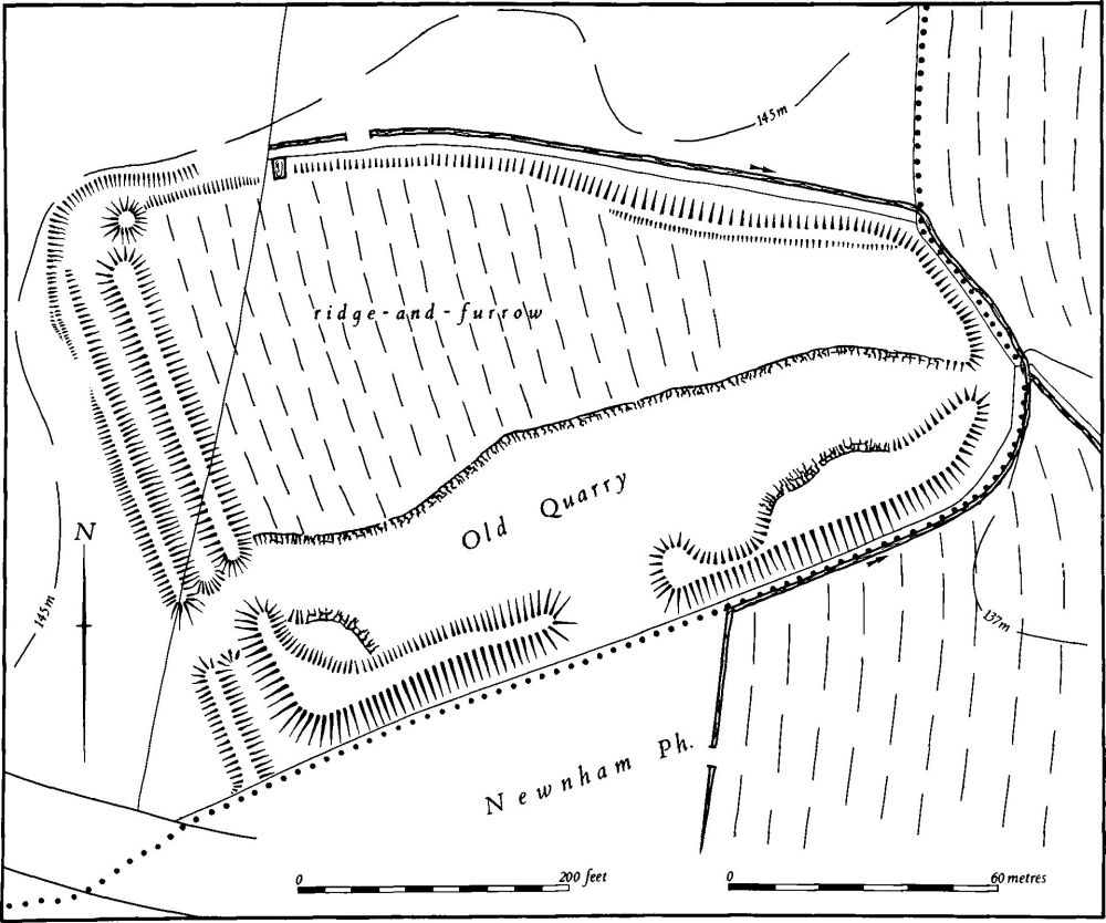
Fig. 58 Daventry (35) Enclosure known as Burnt Walls
b(35) Enclosure (SP 585612; Fig. 58), known as Burnt Walls, lies in the S.E. of the parish, immediately N. of the A45 road, against the Newnham parish boundary in the valley of a small E.-flowing brook. It is set on a low ridge of Jurassic Clay at 136 m. above OD, between the main stream and a small tributary stream on the S. The remains consist of a roughly triangular enclosure bounded on the S.W. by a bank 2 m. high, with an external ditch 2 m. deep and a low counterscarp bank beyond. There is a causeway across the ditch near the S. end which may be an original entrance. At the S. corner the ditch and counterscarp bank disappear and the main bank turns N.E. to follow the edge of the tributary stream. The bank here is between 1 m. and 2 m. high but badly mutilated, especially by quarrying on the inside. A gap which does not appear to be original lies in the centre of the S.E. side. At the N.E. corner the bank is mutilated and only a low scarp above the stream now remains along the N. side and N.E. corner. At this latter place there is a modern entrance gap. The S. half of the interior has been entirely quarried away; the N. half is covered by ridge-and-furrow.
The site has been a curiosity for centuries and no satisfactory explanation for either its date or function has been forthcoming. Morton (Nat. Hist. of Northants. (1712), 519) recorded that 'many Loads of Stones of ruined Walls and Foundations have been digg'd up' and this is repeated by many later writers. Baker (Hist. of Northants., I (1822–30), 339) identified it with the site of Bannaventa, but noted that as it 'had been used before the inclosure as a kind of open quarry, further research would be fruitless'. Since that time dates ranging from the Iron Age to the medieval period have been suggested for this earthwork (OS Record Cards; VCH Northants., II (1906), 399; W. Edgar, Borough Hill and its History (1923), 48–9). About 1899 some depressions within the interior were examined. 'Trenches were run through several of them, but nothing was found' (Ann. Rep. Northants. Exploration Soc., (1900), 7). The site was described as early as 1255 as Les Brendewalles (PN Northants., 19) which suggests that it not only existed at that time, but that its use was already forgotten (air photographs in NMR).