An Inventory of the Historical Monuments in the County of Northamptonshire, Volume 3, Archaeological Sites in North-West Northamptonshire. Originally published by Her Majesty's Stationery Office, London, 1981.
This free content was digitised by double rekeying. All rights reserved.
'Lilbourne', in An Inventory of the Historical Monuments in the County of Northamptonshire, Volume 3, Archaeological Sites in North-West Northamptonshire(London, 1981), British History Online https://www.british-history.ac.uk/rchme/northants/vol3/pp125-128 [accessed 9 May 2025].
'Lilbourne', in An Inventory of the Historical Monuments in the County of Northamptonshire, Volume 3, Archaeological Sites in North-West Northamptonshire(London, 1981), British History Online, accessed May 9, 2025, https://www.british-history.ac.uk/rchme/northants/vol3/pp125-128.
"Lilbourne". An Inventory of the Historical Monuments in the County of Northamptonshire, Volume 3, Archaeological Sites in North-West Northamptonshire. (London, 1981), British History Online. Web. 9 May 2025. https://www.british-history.ac.uk/rchme/northants/vol3/pp125-128.
In this section
43 LILBOURNE
(OS 1: 10000 a SP 57 NW, b SP 57 NE)
The parish, covering just under 680 hectares, lies immediately E. of Watling Street (A5) which forms its W. boundary with Warwickshire, and S. of the R. Avon which is its N. boundary with Leicestershire. The main topographical feature of the parish is a long E.–W. ridge completely covered with Boulder Clay and other glacial deposits between 115 m. and 125 m. above OD. From this ridge the land slopes gently N. to the R. Avon and its tributary, the Clay Coton Brook, at around 90 m. above OD, and S. to another stream at around 95 m. above OD. No Roman site has been firmly located in the parish. There are unsatisfactory records of finds of the period being made in the general area but the proximity of Tripontium a little to the N.W. and speculation by the older antiquaries as to its exact site may have coloured the evidence (e.g. J. Bridges, Hist. of Northants., I (1791), 571).
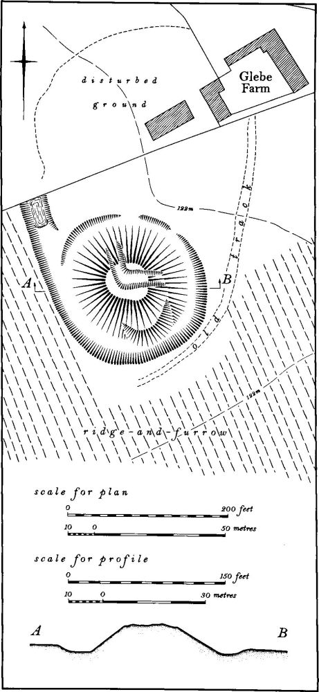
Fig. 96 Lilbourne (1) Motte
The most notable monuments in the parish are two mottes (1) and (2). Both lack any firm documentation. The settlement remains (3) associated with Lilbourne village are especially interesting; not only do they indicate a marked change in the location of the village over many centuries, but they also show that part of the village was at one stage laid out over previously arable land.
Roman
For the Roman Road 1f, Watling Street, see Appendix.
Medieval and Later
b(1) Motte (SP 55337714; Figs. 42 and 96; Plate 2), lies in the N.W. of the parish, immediately S.W. of Glebe Farm, on glacial gravels at just over 122 m. above OD. It stands on the E. edge of a prominent ridge with extensive views in all directions, including part of Watling Street (A5) which lies 450 m. to the S.W. Nothing is known of its date or history. The existence of another motte in the parish (2) is unusual and difficult to explain.
The motte consists of a large circular mound 7.5 m. high, formerly surrounded by a ditch up to 2 m. deep. The latter has been damaged, especially on the N. where it is now hardly visible. The summit of the mound was once probably flat and 15 m. across, but a large L-shaped trench has been cut in it and extends down the N. and E. sides. Some of the spoil from the latter may have been dumped at the bottom of the mound on the S. side where there is a pile of earth projecting into the ditch.
There is little indication of a former bailey. The surrounding land is now under permanent cultivation but air photographs taken in 1945 before the area was ploughed (RAF VAP 106G/UK/636, 4159–60) show ridge-and-furrow to the S., E. and W. of the motte, with what appears to be a track extending S.W. from Glebe Farm and around the S. side. However it is just possible that a bailey existed to the N. of the motte. The outer edge of the ditch on the N.W. side runs on as a well-marked scarp up to 2 m. high and becomes the S.W. side of a modern pond. This may be the W. ditch of a former bailey. The field to the N. was already under cultivation in 1945, but a discoloured area with a curving N. edge is visible on the air photographs. Although this could indicate the area of the bailey the proximity of the modern farm suggests that it is more likely to be a recent feature. No finds have been made in the area.
In 1878 it was recorded that outside the motte ditch to the S.E. was a 'smaller and apparently sepulchral tumulus' (Arch. J., 35 (1878), 119). No trace of this now exists or was visible in 1945. The general area has quantities of relatively modern brick, tile and post-medieval pottery on it, probably to be associated with a farm on the site.
b(2) Motte and bailey (SP 56117747; Figs. 42, 97 and 98; Plate 2), known as Lilbourne Castle, lies N. of the village, near the almost isolated parish church. It is situated in the valley bottom close to the R. Avon, on alluvium and river gravel at 95 m. above OD. Its position is in marked contrast to the other motte in the parish (1) and it appears to control the river crossing. Nothing is known of its date or its history, but the two stages of development visible in the surviving earthworks suggest that it may have started as a small motte and bailey of the late 11th century and was then rebuilt and strengthened perhaps in the mid 12th century.
What appears to be the earliest part of the site consists of a tall conical motte, now 7.25 m. high, with a surrounding ditch and a small sub-rectangular bailey on its N.E. side. The bailey is bounded by a ditch up to 2 m. deep with an inner bank on its S. and E. sides but has been damaged by later activity, including the use of the ditch on the N. side as a track. To the E. of this bailey is a large rectangular depression, probably once a fishpond. To the S.E. of the motte is a later bailey consisting of a rectangular raised platform bounded on three sides by a massive bank and surrounded by a ditch up to 2 m. deep. The bank is some 2.5 m. high except at the S. and S.E. corners where it rises a further 1.5 m. to two prominent mounds. The great size of this bank, and the fact that the bailey is constructed on ground rising out of the valley-bottom, means that it dominates the adjacent motte as well as improving the tactical position of the site from the S.
To the N.E. of the later bailey and immediately S.E. of the fishpond is a small circular mound only 0.25 m. high. It may overlie ridge-and-furrow, but this is not certain. Its purpose is unknown. To the E. and S. of the site is a series of ditched and embanked enclosures, many with ridge-and-furrow within them, that extend S. and form part of the settlement remains (3). A number of hollowed trackways approach and skirt the site but their relationship to it is not clear (air photographs in NMR; RAF VAP 106G/UK/636, 4160–1; CUAP, AGU82, AKP62, AWQ5; Arch. J., 35 (1878), 117–8; 90 (1933), 380; plans and sections, 1842, in Dryden Collection, Northampton Central Library).
b(3) Settlement remains (centred SP 563772; Figs. 11 and 98), formerly part of Lilbourne village, lie E. and N. of the existing village, between it and the now almost isolated church and castle, on glacial sands, clay and gravel between 94 m. and 110 m. above OD. The remains appear to be the result of movement of the village away from an early riverside location near the church to its modern position on the hilltop.
The village is first mentioned in Domesday Book with a recorded population of 28, indicating a sizable settlement (VCH Northants., I (1902), 327, 330). However this figure almost certainly includes Clay Coton which is not listed by name in Domesday Book, but which appears once to have been part of Lilbourne (Fig. 42). The later national taxation records of the village also apparently include Clay Coton, so that any estimate of the size of Lilbourne is impossible. Only the Hearth Tax Returns of 1673 (PRO, E179/254/14) listing 66 houses in the parish gives any indication of the population. However by that time the changes in the village described here had presumably already taken place for in the early 18th century Bridges (Hist. of Northants., I (1791), 571) wrote that 'by the causeys, pavements and ruins that have been dug up, it appears to have been formerly larger than it is at present'. By 1801, 243 people were living in the parish.
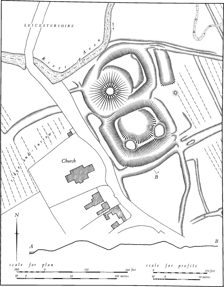
Fig. 97 Lilbourne (2) Motte and baileys
The remains fall into four distinct groups which may in part represent the successive stages of movement. The northernmost ('a' on plan) lie around the church and castle. None of the earthworks here can be said definitely to represent settlement. However it is possible that the three remaining houses and the castle occupy the earlier site of the village, for the system of streets formed by the existing road across the Avon, and three hollow-ways, one running parallel to the river E. of the castle, one approaching it from the S. and one S. of the S. bailey of the castle and apparently cut by the bailey, suggests the possibility of an early occupation in this vicinity. The area S. of the castle, between the modern road and the hollow-way, although completely devoid of earthworks, might well repay excavation in this context.
Further S.E. and N. of the modern road ('b' on plan) is a series of low platforms, banks and scarps all lying within long narrow closes, themselves bounded by low banks and ditches. These closes have notably curved sides the lines of which are continued to the N. and E. by the remaining ridge-and-furrow. They thus appear to have been constructed over earlier blocks of arable land which once extended as far as the road. If this interpretation is correct the area may represent either an extension of the original village near the church, or its movement in a southerly direction when the castle was constructed. A few sherds of medieval pottery of 12th or 13th-century date have been found within the closes.
To the S.E. again, immediately N.E. of the village and between it and the M1 are other earthworks ('c' on plan). The N. part consists of at least five long narrow closes bounded by scarps up to 1 m. high, with traces of former buildings at their W. ends along the existing road, and separated from the ridge-and-furrow to the E. by a massive scarp and a slight outer ditch.
Elsewhere around the village are other features which may relate to former occupation. The existing street running N. of the green continues as a narrow hollow-way with a wide area of unploughed land to the W. and can be traced as far as the modern road S.E. of the church, which it joined or crossed, continuing as the hollow-way to the castle noted above. To the E. of this (S. of 'b' on plan) is a large pasture field which has been ploughed and returned to grass in recent times, so that no clearly defined earthworks are visible, but shallow depressions and traces of ditches on its E. and N.E. side suggest that here too were former houses and closes (RAF VAP 106G/UK/636, 3161, 4160; air photographs in NMR; CUAP, AGU82, AKP62, AWQ5).
b(4) Manor house site (?) (SP 564769; Fig. 98), lies immediately E. of the village on almost level ground, on gravel at 105 m. above OD. The E. part has been destroyed by the M1 and part of the W. has been levelled for a playing field. Its attribution as the site of a manor house rests on the shape of the earthworks, and it may simply be a former part of the village.
The area is bounded on the E. by a broad N.–S. trackway, between low scarps some 0.5 m. high; a narrow hollow-way or ditch joins it from the W. On the N. of the site is another ditch which has a small rectangular pond at its E. end and a large L-shaped pond to the S. The latter is the remnant of a square pond surrounding an island, perhaps a moat but more likely a fishpond with an island in it. Other earthworks once lay to the W. but no trace of these remains (RAF VAP 106G/UK/636, 3161, 4160–1; air photographs in NMR).
b(5) Windmill mound (SP 56417671), lies S. of the village, on the upper edge of a S.-facing slope on glacial gravel at about 105 m. above OD. It consists of a circular mound 20 m. in diam. and 1.25 m. high with a flat top and a central depression in it. There is no trace of a surrounding ditch. Although described as a 'tumulus' on the 1st ed. OS 1 in. map it is almost certainly the site of a windmill (RAF VAP 106G/UK/636, 4160–1).
(6) Cultivation remains. The common fields of the parish were enclosed by agreement in 1680 (NRO, Agreement of Enclosure). From this document it appears that immediately before that date there were three open fields, Hill Field, Crick Path Field and Moor Field, presumably lying W., S. and N.E. of the village respectively. Ridge-and-furrow of the common fields remains intact over large areas of the parish on an impressive scale. It is particularly well preserved E. of Lilbourne Castle (2) where it is set within a series of ditched enclosures (3) (SP 562775; Fig. 98). Elsewhere it remains virtually complete, with many minor features of the medieval landscape still visible. To the N.W. of the village, S.E. of Lilbourne Gorse (SP 55557725–55767712), a broad hollow-way curves down the hillside towards the village with ridge-and-furrow on either side and partly running into it. At its S.E. end, to the E. of the modern road junction (SP 55857710), there appears to have been an open area of unploughed land, as the adjacent ridge-and-furrow to the E. terminates a little short of a low earthen bank leaving an unploughed zone to the W. The intricately interlocked layout of the ridge-and-furrow N.W. of the village (SP 556772) is the result of careful arrangement of furlongs to ensure that the furlongs all run down the slope of the broad curving ridge (RAF VAP 106G/UK/636, 4158–64, 3440–1, 3158–60, 4476–82).