A History of the County of Wiltshire: Volume 17, Calne. Originally published by Victoria County History, London, 2002.
This free content was digitised by double rekeying. All rights reserved.
'Calne: Calne outside the town', in A History of the County of Wiltshire: Volume 17, Calne, ed. D A Crowley (London, 2002), British History Online https://www.british-history.ac.uk/vch/wilts/vol17/pp51-64 [accessed 9 May 2025].
'Calne: Calne outside the town', in A History of the County of Wiltshire: Volume 17, Calne. Edited by D A Crowley (London, 2002), British History Online, accessed May 9, 2025, https://www.british-history.ac.uk/vch/wilts/vol17/pp51-64.
"Calne: Calne outside the town". A History of the County of Wiltshire: Volume 17, Calne. Ed. D A Crowley (London, 2002), British History Online. Web. 9 May 2025. https://www.british-history.ac.uk/vch/wilts/vol17/pp51-64.
In this section
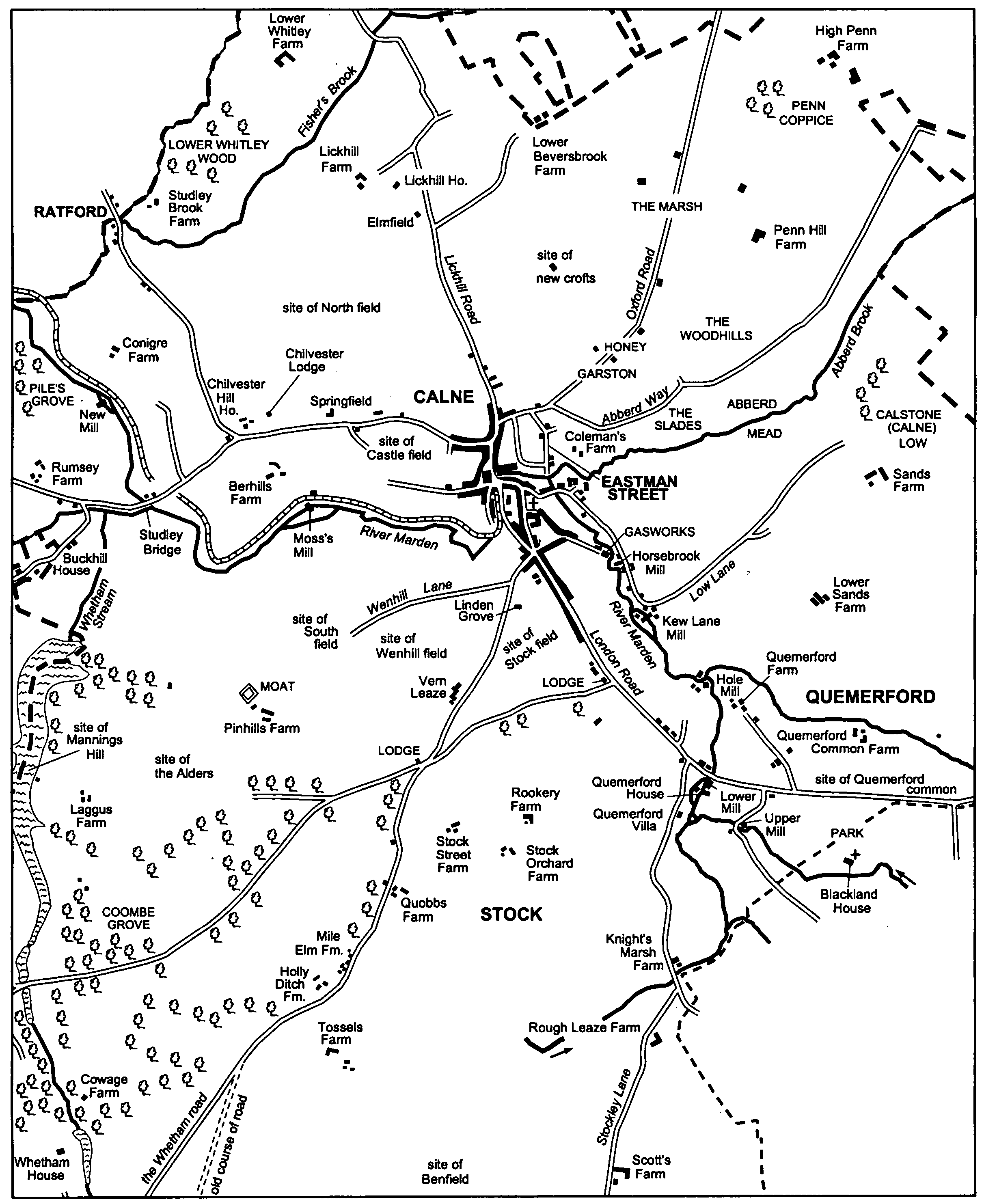
Caline outside the town
Agricultural land north and north-east and immediately southwest and west of the town was granted to Calne church before 1086. It was apparently divided between demesne and customary land and was laid out mainly as open fields and commonable meadows and pastures. At the time of the grant Calne may already have been a locally prominent settlement and, perhaps soon after the grant, a north-south street village was planted, and the land was worked from farmsteads built in it. (fn. 1) The village, evidently planned, consisted of a demesne farmstead and a mill standing, with the church, as a small group beside the Marden, and of the farmsteads of the customary tenants in a line north of them; (fn. 2) it had much in common with many other settlements in Wiltshire planted or reorganized in the Saxon period. (fn. 3) It stood east of the town and by the 14th century had been given the name Eastman Street. (fn. 4) In the earlier 18th century there remained a mill and several small farmsteads in the street (in 1728 called Eastmead Street). They remained those of the church's estate, from the 1220s held by the treasurer of Salisbury cathedral, (fn. 5) the street was later called Broken Cross Road, (fn. 6) but there is no direct evidence that a cross stood among the farmsteads.
The largest farmstead in Eastman Street, that on the demesne, may have gone out of use as a farmstead in the 18th century; (fn. 7) it was given to the vicar of Calne in the early 19th century, from when the farmhouse was the vicarage house. (fn. 8) The others probably went out of use as farmsteads in the late 18th century or early 19th. (fn. 9) In 1999 the farmhouses of two survived: each is of the late 17th century or early 18th and has been converted to two cottages (nos. 17 and 19, and nos. 55 and 57, the Pippin). Near the south end of the street a house (no. 61 the Pippin) abutting one of the farmhouses was apparently built in the early 19th century, (fn. 10) and from the late 19th century Broken Cross Road (later the east part of the Pippin) was embraced by the town. (fn. 11)
Eastman Street was a nucleated settlement with open fields and commonable meadows and pastures around it, and it is possible that dispersed settlement north and east of the town was displaced when it was planted and the open fields and other commonable lands were laid out. On land beyond the open fields immediately west and south-west of the town, and bounded by the Whetham stream and for short distances by the Marden and Cowage brook, there was dispersed settlement and no openfield land. It is possible that the dispersed farmsteads stood on sites in use before open fields were laid out and nucleated villages planted, but more likely that they were built on pasture which was demesne of the king's estate called Calne and perhaps of Calne manor, was granted away piecemeal, and was afterwards divided into closes. Houses and farmsteads were also built on scattered closes north and east of the town, and in the earlier 18th century c. 13 stood dispersed around the town. The sites of the open fields were not built on much until the town expanded in the 20th century. (fn. 12)
South-west of the town a principal house stood on each of five small freehold estates, including those called Pinhills, Laggus, and Cowage. That on the Pinhills estate stood on a moated site and was presumably built in the Middle Ages, that on the Cowage estate had been built by the 16th century, and that on the Laggus estate was built or replaced in the 17th century. (fn. 13) Those on two small estates near the woodland called Coombe grove were standing in 1728. (fn. 14) One had been demolished by 1843; (fn. 15) buildings on the site of the other were demolished in the later 20th century. (fn. 16)
On closes west and north-west of the town Chilvester Hill House (later Chilvester House) was built as the principal house on a small freehold estate, and three farmsteads, Berhills, Conigre, and Swerves were built. All were standing in 1728. (fn. 17) Berhills Farm had been built by the earlier 17th century (fn. 18) presumably on the site it occupied in 1728; c. 1840 its farmhouse was rebuilt with gables, windows, and a porch all in Tudor style, perhaps replicating features of the earlier house. Conigre Farm remains on the site it occupied in 1728; its farmhouse was rebuilt in the 19th century. In 1728 Swerves was a small farmstead on the south bank of Cowage brook; (fn. 19) by 1843 the farmstead had been renamed Studley Brook Farm, and between 1843 and 1885 it was demolished. New buildings were erected on the site between 1899 and 1922, and a new house was built there in the late 20th century. By 1885 the name Swerves Farm had been transferred to a small farmstead standing c. 350 m. south of Studley Brook Farm in 1843; the farmhouse there was rebuilt about the 1870s and the name was perhaps acquired then. (fn. 20) Swerves was the only one of the farmsteads used for farming in 1999. Immediately east of Studley bridge, a site on which cottages were standing in 1728 apparently on the verge of the London road, (fn. 21) a house was built in Jacobean style probably c. 1840. (fn. 22) None of the cottages survives, and between 1843 and 1885 the name Studley Brook Farm was transferred to the house. (fn. 23)
North and north-east of the town three farmsteads had been built on inclosed land by 1728. It is possible that their sites were used for farmsteads before Eastman Street was planted, but more likely that they were built on early inclosures of the commonable land. Lickhill Farm, near the centre of 99 a. of inclosed grassland, was standing in 1728. (fn. 24) In 1999 it consisted of buildings still used for farming and of a farmhouse which seemed to be mainly of the 18th century and early 19th. The other two farmsteads were built on land which had probably been part of a common pasture called Penn (fn. 25) and occupied adjacent sites. One of them, High Penn Farm, was a large farmstead in the 19th and 20th centuries, (fn. 26) and many, largely disused, buildings remained on its site in 1999. The farmhouse was apparently rebuilt in the late 18th century or early 19th. The farmhouse on the adjacent site had been burned down by 1728. (fn. 27) A barn and farmyard stood on the site until the 20th century. (fn. 28) Nearer the town Penn Hill Farm was built in the 18th century. Its farmhouse was extended in the 19th century and altered in the 20th; the adjacent buildings had mainly industrial uses in 1999.
Two small farmsteads were built a little east of the town. Coleman's Farm, on a small, inclosed, freehold estate, is slightly more likely to have occupied a site in use for a farmstead before Eastman Street was planted than are the three farmsteads which in 1728 stood north and north-east of the town. It was standing in 1728. (fn. 29) In the mid 19th century its farmhouse was rebuilt of coursed stone rubble in a 17thcentury style. (fn. 30) Newcroft Farm was built in the late 19th century. (fn. 31) In the 20th century Coleman's farm and Newcroft farm were built over (fn. 32) and both farmsteads were demolished. Off the Melksham and Devizes road a little south of the town a three-bayed house (no. 3 Linden Close) was built apparently as a farmhouse in the 18th century. (fn. 33)
In addition to the farmsteads, estate cottages and houses were built, usually in pairs, in the 19th and 20th centuries. North of the town, beside the road which continues Lickhill Road and leads circuitously to Malmesbury, a pair of stone cottages was built in 1883 and two pairs of council houses were built c. 1920. Beside the turnpike road built north-east of the town c. 1791 a pair of stone-faced cottages was built between 1885 and 1899, and near High Penn Farm three pairs of cottages and houses were built between the late 19th century and the mid 20th. Beside the Bristol road west of the town a pair of stone cottages was built between 1843 and 1885, later extended, and afterwards converted to one house, and a pair of stone-faced cottages with brick dressings was built in 1914. Beside the lane leading to Ratford a pair of cottages in domestic revival style was built in 1908. Two pairs of cottages of stone and brick were built in a 19th-century idiom although not until the 1920s, one beside the Bristol road in 1926, the other beside the Ratford lane in 1927. (fn. 34)
Large houses were built outside, and on most sides of, the town mainly in the 19th century and presumably for men prospering through business in the town. As the town grew in the 20th century it came up to, or embraced, most of them.
Calne outside the town, 1843: from the map on pages 28, 31
North of the town four large houses stand beside or off Lickhill Road and the Malmesbury road. (fn. 35) Elmfield (formerly Lickhill House) is a three-bayed house built in the early 19th century and altered in the late 19th or early 20th century. (fn. 36) Lickhill House, northwest of Elmfield, was built or greatly altered in the early 19th century and extended eastwards between 1899 and 1922. (fn. 37) Further north Fisher's Brook House was built mainly of brick in the 1920s although in a slightly earlier style. (fn. 38)
South of the town Vern Leaze (formerly Highlands) is a small mansion built in a small park in or shortly after 1813. (fn. 39) It is of two storeys and roughly square in plan, is faced in ashlar, and has a loggia in Greek revival style. A contemporary stable court stands to the southwest, and between 1843 and 1885 a lodge was built to the north-east beside the Melksham and Devizes road. (fn. 40) Linden Grove is a large house, of two storeys and a basement, built in the early 19th century as a three-bayed west range of the apparently 18th-century farmhouse now no. 3 Linden Close. (fn. 41)
South-east of the town two large houses in domestic revival style were built at or near Quemerford. Wessington House, on the northeast side of the London road, was built in 1905 of brick with half-timbered gables to designs by (Sir) Harold Brakspear. (fn. 42) Ebor House, on the south-west side of the London road, was built in 1907 with features, such as a conical cap on a large polygonal bay window, typical of northern France; it was demolished in 1997. (fn. 43) In Stockley Lane near Quemerford the Croft (formerly Quemerford Villa) was built in a miniature park in the early 19th century as a two-storeyed villa and is of dressed stone with ashlar dressings, has an ashlar portico on its entrance front to the north-west and a fullheight bow on its garden front to the south-east, and was extended to the north-east in the earlier 20th century. (fn. 44)
West of the town four large houses were built on the north side of the Bristol road near Chilvester House (formerly Chilvester Hill House). (fn. 45) Chilvester Lodge, immediately east of Chilvester House, was built in the early 19th century of two storeys and attics and with a main three-bayed front of ashlar; a singlebayed west range later replaced part of a service wing. Springfield, east of Chilvester Lodge, was built in 1820 for William Gundry (d. 1851), a grocer in Calne, (fn. 46) as a two-storeyed and three-bayed house of dressed stone with a symmetrical main south front. Between 1885 and 1899 Oak Lea (later Chilvester Hill House), a plain two-storeyed house with gables, was built immediately west of Chilvester House, and in the 1890s the Grange, in domestic revival style, of red-brick and with a half-timbered upper storey, and gabled, was built immediately east of Springfield; (fn. 47) in 1999 the Grange was in use as Springfields school. (fn. 48)
Of several pockets of settlement on or at the edge of Calne's agricultural land Mannings Hill, a settlement in the 17th century, (fn. 49) was probably the earliest and largest. Mannings Hill stood, on the east edge of Bowood park, along and off that course of the Calne-Bath road which ran via Pinhills Farm to Cuff's Corner where the road crossed the Whetham stream. In 1728 it consisted of a loose group of several homesteads, from some of which small holdings of agricultural land may have been worked, and of cottages on the verges of the road. Only one building stood on the west bank of the stream. (fn. 50) Nearly all the houses and cottages were demolished in 1766, when the Whetham stream was dammed to make a lake in the park of Bowood House, (fn. 51) and on the east shore of the lake there was only one building in 1776 on or near the site of Mannings Hill. (fn. 52) That building was replaced by a cottage in the early 19th century. (fn. 53)
Ratford (otherwise Rattle) (fn. 54) was the name given to a hamlet north-west of the town where, immediately below its confluence with Fisher's brook, Cowage brook was forded by a lane. Although in the earlier 17th century the lane evidently crossed the stream on a bridge, (fn. 55) in the earlier 18th there was apparently no more than a ford. (fn. 56) The oldest buildings at Ratford in 1999, and probably the first to be built there, were apparently of the late 17th century or early 18th and stood in Bremhill parish. Between 1728 and 1773, and probably about the same time as each other, a single-span bridge was built across Cowage brook, and a twostoreyed house of large sandstone blocks and with two-light mullioned windows was built a little west of it in Calne parish. (fn. 57) The combined stream was used for baptizing, large walls retaining its course survive, and a mission room for Baptists was built in 1900. (fn. 58) Another house in the part of the hamlet in Calne parish was built apparently in the early 19th century.
Beside the Wootton Bassett road north-east of the town the Bricklayers Arms, open in 1999 as the Bug and Spider, was built soon after 1843. Later in the 19th century two small houses and two pairs of cottages were built immediately north of it. (fn. 59)
Blackland and Calstone
Some settlement at Blackland, including some of that at Theobald's Green, and much of Calstone village lay in Calne parish. The whole of Blackland and of Calstone village are described elsewhere in the volume under the headings of, respectively, Blackland and Calstone Wellington.
Derry Hill (fn. 60)
In the 18th century there were three lines of settlement along the London- Bristol road at or near the north-west corner of the park of Bowood House. They seem to have borne the names Rag Lane, Red Hill, and Derry Hill and to have stood mainly in Calne and Bremhill parishes and in what became Pewsham parish. That apparently called Derry Hill stood to the west in Pewsham; by the earlier 19th century it had apparently lost the name Derry Hill, by 1999 it had not been linked by buildings to the other lines of settlement, and it is not discussed further in this sub-section. Rag Lane and Red Hill may each have originated as a line of cottages and small houses built on the verge of the main road by squatters. Most of Rag Lane stood in Calne parish, the rest in the peninsula of Bremhill parish transferred to Calne in 1883. In 1709 the justices at quarter sessions found part of Red Hill to lie in Bowood liberty; c. 1840 nearly all of it lay in Pewsham and in 1984 was transferred to Calne Without. The whole of both Rag Lane and Red Hill are discussed here. The new section of the London-Bristol road built between 1787 and 1810 bypassed them to the north; a few cottages or houses at Red Hill stood beside that part of the old road used by Chippenham-Devizes traffic. (fn. 61) In 1839-40 a church was built on a site in Calne parish between the two lines of settlement, and in 1841 an ecclesiastical district called Derry Hill was assigned to it: (fn. 62) Rag Lane and Red Hill, linked by the church, a vicarage house, and a school, thereafter jointly assumed the name Derry Hill. (fn. 63)
In the eastern part of Derry Hill, formerly Rag Lane, two thatched cottages of the 17th or 18th century and an 18th-century cottage remain from those apparently built on the verge of the old London-Bristol road, and there are a few houses evidently of the late 18th century or early 19th. At the west end of what was Rag Lane a house, in 1999 two houses, was built in the 18th century beside a lane leading north to Studley, and a house was built c. 1800 at an entrance to the park of Bowood House. (fn. 64) Also beside the lane a nonconformist chapel was built in 1814 (fn. 65) and a pair of cottages, in 1999 one house, was built in the 19th century. At the corner of the lane and the old road a school was built in 1843. It was converted to a workmen's club in 1873, was in use as a reading room in 1885, (fn. 66) and was a village hall until the later 1990s. (fn. 67) Where the lane crosses the new London- Bristol road two pairs of red-brick estate cottages were built, one in 1885 and one in 1895. (fn. 68) Elsewhere in the old Rag Lane in 1999 there were c. 20 other houses, of the 19th century or the 20th; most stood on sites apparently occupied in the earlier 18th century (fn. 69) and they included three pairs of 19th-century estate cottages.
In the western part of Derry Hill, formerly Red Hill, c. 30 houses and cottages were standing c. 1838. Of the cottages and houses apparently built on the verge of the old main road only an 18th-century cottage on the south side and two 18th-century houses on the north side survived in 1999. Two cottages on the verge of the Devizes road at its junction with the old main road, one built in the 17th century and one in the 18th, were also standing in 1999. A drive across the park from Bowood House joined the old main road near that junction, and c. 1838 the Lansdowne Arms (formerly the Shelburne Arms) stood on the south side of the old main road near the entrance to the park, and a farmstead stood on the west side of the Devizes road a little north of the junction. (fn. 70) Between the 1830s and the 1850s the old buildings near the junction, including the Lansdowne Arms and the farmstead, were replaced by ones which were built to a consistent design to create a small picturesque estate village. On the south side of the old main road a stone cottage in Tudor style had been built by c. 1838 near the entrance to the park, possibly as a lodge, and immediately north-east of it a pair of picturesque stone cottages had also been built by then. About 1841 an arch and belvedere called the Golden Gate was built across the entrance to the park on or near the site of the old Lansdowne Arms. (fn. 71) A new Lansdowne Arms, dated 1843 and open in 1999, was built on the north side of the old main road at the junction, and a cottage and two pairs of cottages, each of stone and in picturesque Tudor style, were built nearby; (fn. 72) one of the pairs was built on the west side of the road north of the junction in 1853. (fn. 73) Also in the 19th century c. 13 other cottages and houses were built in what was formerly Red Hill, including a house dated 1879, a trio of cottages dated 1885, and, on the east side of the road north of the junction, a half-timbered house.
The character of Derry Hill was changed by the building of the Golden Gate, the replacement of buildings near it, and the building of the church, the vicarage house, and the school further east. (fn. 74) It was changed again in the later 20th century, when much new housing was built west of the church. Houses were built to fill spaces on the north side of the old main road, a block of seven bungalows for old people was built, and in 1963 a home for c. 30 old people was opened. (fn. 75) Between the 1970s and 2000 c. 220 houses were built to fill much of the space between the old road and the new road north of it, c. 120 in the 1970s and c. 100 in the 1990s. (fn. 76) East of the church the vicarage house was replaced by a nursing home, and a new village hall was built in 2000. (fn. 77) The west end of the village, including the Golden Gate, the Lansdowne Arms, and the cottages built between the 1830s and 1850s, was designated a conservation area in 1986. (fn. 78)
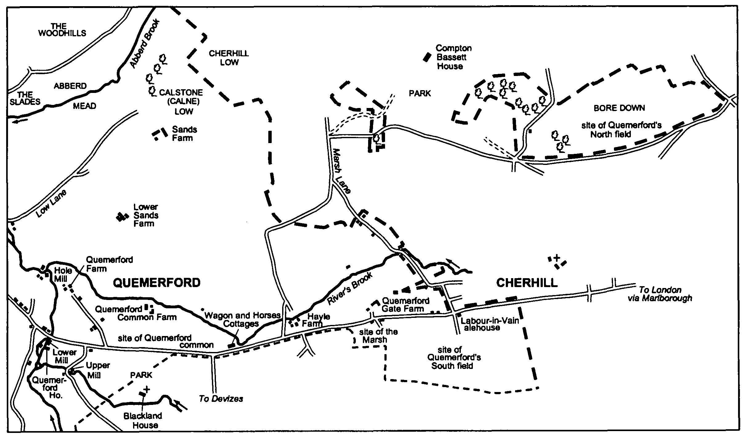
Quemerford
The land of Quemerford lay east of Calne and included open fields to the east. (fn. 79) A chapel may have stood at Quemerford in the mid 13th century, (fn. 80) and Quemerford had 45 poll-tax payers in 1377. (fn. 81)
In 1728 there were 10 dispersed farmsteads standing north of the London road east of the Marden. (fn. 82) Before then the pattern of settlement is obscure. It is possible that a village of small farmsteads, from which the open fields were worked, was planted when, presumably in the earlier Middle Ages, the fields were laid out. That mills stood at Quemerford on the Marden near where the river was crossed by the London- Bristol road, (fn. 83) and that the name Quemerford is likely to have been applied first to a settlement at or near a river crossing, (fn. 84) suggest that, if there was such a village, its centre was near the crossing. There is no direct evidence of such a village, and the great distance of the open fields from the crossing casts doubt on its existence, and thus on the possibility that the dispersed farmsteads were built on inclosures of extensive and formerly commonable pasture between the open fields and the Marden to replace it. It is more likely that no such village existed, that the farmsteads stood on sites inclosed and in use for farmsteads before the open fields were laid out, and that the assignment of open-field land was not accompanied, as it apparently was at Eastman Street, by the planting of a new village. (fn. 85)
The Marden had apparently been bridged at Quemerford by 1391, when a burgess of Bristol gave money to maintain a bridge between Calne and Cherhill. (fn. 86) From the mid 17th century or earlier a mill stood c. 450 m. north of Quemerford bridge, and Quemerford House and the mills later called Lower and Upper stood near the bridge and south of the road. (fn. 87) In 1728 small groups of buildings stood beside the London road west of the bridge. (fn. 88) Quemerford bridge was widened in 1823. (fn. 89)
Of the 10 farmsteads in 1728 Sands Farm stood on the ridge between Rivers brook and Abberd brook. The surviving farmhouse was apparently built in the early 18th century on an L plan. South of it the farmhouse of Lower Sands Farm was rebuilt in the later 19th century. The other eight farmsteads stood in a roughly east-west line, and three of them stood near the edge of Quemerford's remaining common pasture. (fn. 90) To the west Quemerford Farm stood on the ridge between the Marden and River's brook north of Quemerford bridge. Its farmhouse was built of stone on an L plan in the late 17th century or early 18th; it was altered in the 19th century and refitted c. 1980. (fn. 91) Further east Quemerford Common Farm is an 18thcentury farmhouse with a three-bayed south front, and the farmhouse at Hayle Farm was rebuilt c. 1800 with a Gothic porch and firstfloor sashed windows with Gothic heads. East of Hayle Farm an early 18th-century house of stone and thatch, which was standing in 1999, was part of a small farmstead in 1728 (fn. 92) but not later. Quemerford Gate Farm was built immediately east of it in the mid 18th century (fn. 93) with a farmhouse which was rebuilt in simple Tudor style in the later 19th century. Of those six farmsteads only Quemerford Farm and Sands Farm were used for farming in 1996. Little of the other four survives. One stood beside the London road c. 1.25 km. east of Quemerford bridge. (fn. 94) A house and three cottages stood there in 1843. (fn. 95) A block of cottages standing there in the late 19th century and early 20th was called Wagon and Horses Cottages, although there is no direct evidence of an inn or beerhouse there. A row of four 19th-century houses and cottages and a house, dated 1855 and called Queenborough Cottage in 1885, (fn. 96) stood there in 1999.
The buildings west of Quemerford bridge in 1728 stood on and off the north side of the London road and included a toll house; (fn. 97) in 1763-4 there were c. 12. (fn. 98) Few, if any, of those buildings survived in 1999. The toll house was rebuilt on the south side of the road apparently in the early 19th century. (fn. 99) On the north side of the road the Talbot, which occupies a stone house of the later 18th century, was open as an inn or alehouse in 1822 (fn. 100) and as a public house in 1999. Between the Talbot and the bridge, on or near sites occupied in 1728, there were in 1999 c. 12 cottages and small houses standing in three short rows and apparently dating from the later 18th century to the later 19th.
Immediately east of Quemerford bridge Lower mill was rebuilt as a cloth factory c. 1800, and a house adjacent to the factory was built c. 1850. Upper mill was enlarged in or shortly before 1860. (fn. 101) Apparently between 1843 and 1885 several stone houses and c. 40 cottages were built on the north side of the London road east of the bridge (fn. 102) presumably for those managing and working in Upper mill and Lower mill. The houses included Prospect House, a symmetrical three-bayed villa. The cottages stand in terraces of various lengths; most are of two bays and two storeys and faced in stone, and some have mullioned windows. A nonconformist meeting house was built in 1860 (fn. 103) and a red-brick beerhouse was built between 1867 and 1875. The beerhouse was opened as the New inn, was altered in 1904, (fn. 104) and was open as the Jolly Miller in 1999. Also apparently between 1843 and 1885 a group of c. 12 cottages, including none of high quality, was built on land off the north side of the London road and near the east bank of the Marden. (fn. 105)
Quemerford in 1843: from map on page 31
In 1852-3 a church and in 1867 a school were built on the north side of the London road between Calne and Quemerford, (fn. 106) and in the 20th century the built-up area of Calne was extended south-east of them to the Marden at Quemerford. In the earlier 20th century 10 houses in domestic revival style were built along the south-west side of the London road, and in the later 20th century estates of houses and bungalows were built off both sides of the road and in and off Stockley Lane. (fn. 107) The new houses built in the 1990s included 6 on the garden of Wessington House and 4 in the grounds of the Croft; 19 were built on the site of Ebor House in 2000. (fn. 108) Also in the 20th century c. 85 houses and bungalows were built as a ribbon along the north side of the London road between the houses and cottages built apparently between 1843 and 1885 and Wagon and Horses Cottages. The buildings, in mixed styles, include a pair of houses dated 1924 and, at the east end, two pairs of council houses built c. 1920. (fn. 109) On the south side of the London road the grounds of Quemerford House and the park of Blackland House had not been built on by 1999. (fn. 110)
Other settlement on Quemerford's land in 1728 included cottages on the south verge of the London road near the site of Quemerford Gate Farm, and a tenement on a similar site near Cherhill village. (fn. 111) A cottage, possibly 18thcentury, survives on the first site, and a house of c. 1900 and a 20th-century farmstead, in 1999 called Gate Farm, replaced other buildings there. A building on the second site was apparently the Labour-in-Vain alehouse in 1763-4 and 1828. (fn. 112) There is no later evidence of it as an alehouse, and cottages on its site and possibly converted from it were demolished in 1904. (fn. 113) By the 19th century the name Labour-in-Vain Hill had been given to the steep section of the London road leading from Calne to Cherhill. (fn. 114) A thatched cottage built near Cherhill on the north verge of the London road between 1728 and 1764 (fn. 115) survived in 1999, and a pair of brick cottages built in the 19th century stood nearby.
In Marsh Lane near Cherhill village a nonconformist chapel was built in 1832 (fn. 116) and a pair of bungalows in the earlier 20th century near several houses in Cherhill parish. As part of Cherhill village 6 council houses and later 11 bungalows were built on land of Quemerford transferred to Cherhill parish in 1934. (fn. 117) North of Hayle Farm c. 160 plain brick houses, semidetached or in short terraces, were built in a landscaped setting as married quarters for R.A.F. Compton Bassett in the mid 20th century; c. 40 other houses were built in the late 20th century. (fn. 118)
Sandy Lane (fn. 119)
A small settlement along the section of road which was common to the London-Bath and Chippenham-Devizes roads stands on Lower Greensand and by 1675 had been given the name Sandy Lane. (fn. 120) It had short offshoots along the Chippenham-Devizes road north and south of the common section, and to the south-east in the London road. In 1728 and 1764 it consisted of c. 20 houses and cottages, (fn. 121) in the early 1840s of c. 35 tenements. Several buildings at the north end stood outside Calne parish. (fn. 122)
An inn called the White Hart, at the south end and on the east side of the common section of road, was open in 1674, 1747, and probably 1763-4. (fn. 123) The London-Bath road via Sandy Lane became less important from the mid 18th century, (fn. 124) and the White Hart is not known to have been open after 1764. A house of ironstone with ashlar dressings, incorporating a pediment on brackets above its main entrance, was built on its site in the later 18th century and was standing in 1999. The George, at the north end and on the east side of the common section, was open in 1728, (fn. 125) probably in 1720, and in 1999. The present building bears the date 1720, is 18th-century, and was refronted in the 19th century. The Black Horse, apparently opened after 1728, was burned down in 1749. (fn. 126)
Several houses apparently of the 18th century or earlier stood at Sandy Lane in 1999 besides the George and the White Hart or its replacement. All are of stone and thatch (fn. 127) and they include about five cottages and houses at the north end of the village near the George, and two houses at the south end of the common section of road near the site of the White Hart. In that part of the London road to the southeast, which as it declined in use was given the name Back Lane, (fn. 128) four buildings comprised eight tenements in 1843. (fn. 129) Three survived in 1999, each apparently of 18th-century origin, altered and extended, and occupied as a single house.
An entrance to the park of Bowood House from the south lay at the north end of Sandy Lane and, as at Derry Hill, buildings near the entrance were replaced and improved on in the earlier 19th century. A picturesque lodge was built at the entrance, (fn. 130) and nearby about six cottages and pairs of cottages were built of ironstone and thatch and in picturesque style. A nonconformist chapel, also of ironstone, was built halfway between the two ends of the village in 1817. (fn. 131) A few other cottages and houses were built beside the Chippenham-Devizes road in the 19th century, a small church of wood and thatch was built in 1892 in Back Lane, (fn. 132) and, also in the 19th century, several cottages, only one of which survived in 1999, were built at the junction of Back Lane and the road from Calne to Melksham and Devizes. In 1885 there was a saw mill at the junction of Back Lane and what was still the main Chippenham-Devizes road, (fn. 133) and farm buildings were erected there later.
In the 20th century only two new houses were built at Sandy Lane, one in Back Lane and a police house near the north end of the village, and extensions to and alterations of the cottages and houses in the village were carried out with materials and in styles sympathetic to those of the earlier 19th century. Sandy Lane was designated a conservation area in 1974; the designated area was revised in 1994. (fn. 134)
Stock and Stockley
The names Stock and Stockley were given to adjacent areas of dispersed settlement. Stock lay north of Stockley, (fn. 135) the boundary between them being otherwise uncertain, and this sub-section deals with a triangle with its apex near the south-west corner of the Green in Calne, the parish boundary along the Roman road as its base, the boundaries with Blackland and Quemerford as its east side, and the road between Calne and Devizes via Heddington Wick as its west side. (fn. 136)
The names Stock and Stockley suggest that the two areas were colonized from Calne, that when farmsteads were first built on it the land was pasture, and that Stockley's pasture lay near woodland. (fn. 137) Neither Stock nor Stockley was mentioned as a village or estate in Domesday Book, and in neither area is there known to have been a nucleated settlement or more than a small amount of open-field land. (fn. 138) There were three main lines of settlement. Farmsteads stood at intervals along each side of the triangle, the centre of which was apparently commonable pasture, and in each case were linked by a roughly straight road. In 1728 there were c. 26 farmsteads of which 16 stood along the sides of the triangle, 6 on closes within the triangle and away from roads, and 4 in a group at what was called Stockley Green in the 19th century, Stockley in the 20th. (fn. 139)

Stock and Stockley in 1843: from the map on page 28, 31
Along the east side of the triangle, besides the four at Stockley Green, five farmsteads were standing in 1728, including those then or later called Knight's Marsh, Rough Leaze, Scott's, and Elm Hurst. (fn. 140) In 1687 Knight's Marsh farmhouse was apparently said to have been recently built; (fn. 141) the present farmhouse seems to have been built in the earlier 19th century and extended later to give it an L plan. The farmhouse of Rough Leaze was rebuilt in 1869 as a villa with gables, projecting timber eaves, and simple hoodmoulds over the windows, and that of Scott's was rebuilt in 1872 in a similar style. (fn. 142) That of Elm Hurst is a smaller red-brick mid 19th-century house, the rear wing of which incorporates what may be a fragment of an earlier stone building, and an adjacent pair of 19th-century cottages mainly of red brick also incorporates some stone walling. In 1999 the buildings of only Elm Hurst were used for farming; by then nearly all those of Scott's and some of those of Knight's Marsh had been removed, and those of Rough Leaze were then being removed or converted for residence.
Along the south side of the triangle seven farmsteads were standing in 1728, including those later called Bell's, Stockley, Willowbrook, and Broad's Green. (fn. 143) At Stockley Farm what may have been a farmhouse built of stone in the 18th century was apparently reconstructed in brick as cottages, was extended in the 20th century, and was occupied as one house in 1999. At Willowbrook Farm the farmhouse was replaced by a large house of stone with red-brick dressings built in the later 19th century; at Bell's Farm it was replaced by a house built in 1904. (fn. 144) Broad's Green Farm was rebuilt in the mid 19th century with a gabled farmhouse of two low storeys and stone farm buildings; the farmhouse was extended in the 20th century. The buildings of Stockley and Willowbrook were used for farming in 1999, those of Bell's then had other commercial uses, and those of Broad's Green, including some of the 19th century, also had other uses. The buildings which stood on the other three sites in 1728 had gone out of use as farmsteads by the mid 19th century, (fn. 145) and none of them survives. Between Stockley Farm and Bell's Farm a house and six cottages were built in the 19th century on the site of one farmstead, and between Willowbrook Farm and Broad's Green Farm a pair of stone cottages with red-brick dressings was built on that of another.
Beside the road along the west side of the triangle there were four farmsteads in 1728, those later called Holly Ditch, Mile Elm, and Quobbs and one on the west side of the road near Quobbs. (fn. 146) In 1999 there was apparently no surviving building as old as 1728. The farmhouse of Holly Ditch may have been replaced by a three-bayed house built in the late 18th century, and in the later 19th century that house was embraced by a larger farmhouse with mullioned windows and decorative bargeboards. Buildings on the site of Mile Elm Farm in 1999 included a plain ashlar-faced early 19th-century farmhouse, a three-bayed brick house of similar date, and a pair of red-brick and gabled later 19th-century cottages. The farmhouse of Quobbs, which was built in the earlier 17th century, (fn. 147) was replaced by a long and low stone house in the late 18th century or early 19th. In 1999 no building stood on the site of the fourth farmstead standing in 1728. Some buildings at Mile Elm Farm and Quobbs Farm were used for farming in 1999; those at Holly Ditch Farm, including large ones of the 19th century, were apparently not.
On closes within the triangle there were six farmsteads in 1728, towards the north those then or later called Rookery, Stock Orchard, and Stock Street, near the centre that called Tossels and one immediately south-east of it, and towards the south one on a site called Pool's Leaze in the 19th century. (fn. 148) The farmsteads called Stock Orchard and Rookery stood on the same farm in 1843, when there was a farmhouse at Stock Orchard and apparently none at Rookery. (fn. 149) By 1885 the farmhouse at Stock Orchard had been demolished and a large stone farmhouse with mullioned windows, hoodmoulds, and carved bargeboards had been built at Rookery. (fn. 150) All the buildings of Stock Orchard Farm had been demolished by the late 20th century, (fn. 151) and in 1999 those of Rookery Farm were not used for farming. Marden Farm, large buildings to house pigs, was built east of Rookery Farm in the later 20th century. (fn. 152) Stock Street farmhouse was rebuilt apparently in 1823; (fn. 153) the farm buildings were demolished in the late 20th century. (fn. 154) Tossels Farm, including a house built in the early 20th century, was a farmstead in 1999. The other two farmsteads standing in 1728 were small in 1843. (fn. 155) In 1999 little remained on the site of that south-east of Tossels Farm and no building stood at Pool's Leaze.
The buildings of three of the four small farmsteads at Stockley Green in 1728 had apparently been demolished by 1843. (fn. 156) In the 20th century a farm building alone occupied the site of the fourth. (fn. 157) There nevertheless remained a pocket of settlement at Stockley Green at or near the junction of the roads along the south and east sides of the triangle. A row of 18th-century or early 19th-century thatched cottages, a terrace of four red-brick cottages of the earlier 19th century, two 19th-century houses of which one was built in 17th-century style and of stone, a pair of estate cottages built c. 1932, (fn. 158) and two mid 20th-century bungalows constituted the hamlet in 1999. Broad's Green Farm was part of a hamlet called Broad's Green in the 18th and 19th centuries. (fn. 159) In 1999 the hamlet consisted of the former farmstead, two 20th-century houses, and an older house altered in the 20th century.
North of Quobbs Farm a house built after 1843 on the east side of the road was used as an isolation hospital in the 1880s. (fn. 160) Near it on the west side of the road a small gabled house of stone and stone slates was built in the later 19th century. In the 20th century houses were built on scattered sites beside the roads along each side of the triangle. They included four pairs of council houses built c. 1920. (fn. 161) In the late 20th century Calne grew across Stock's land, including former open-field land, at the north apex of the triangle. (fn. 162)
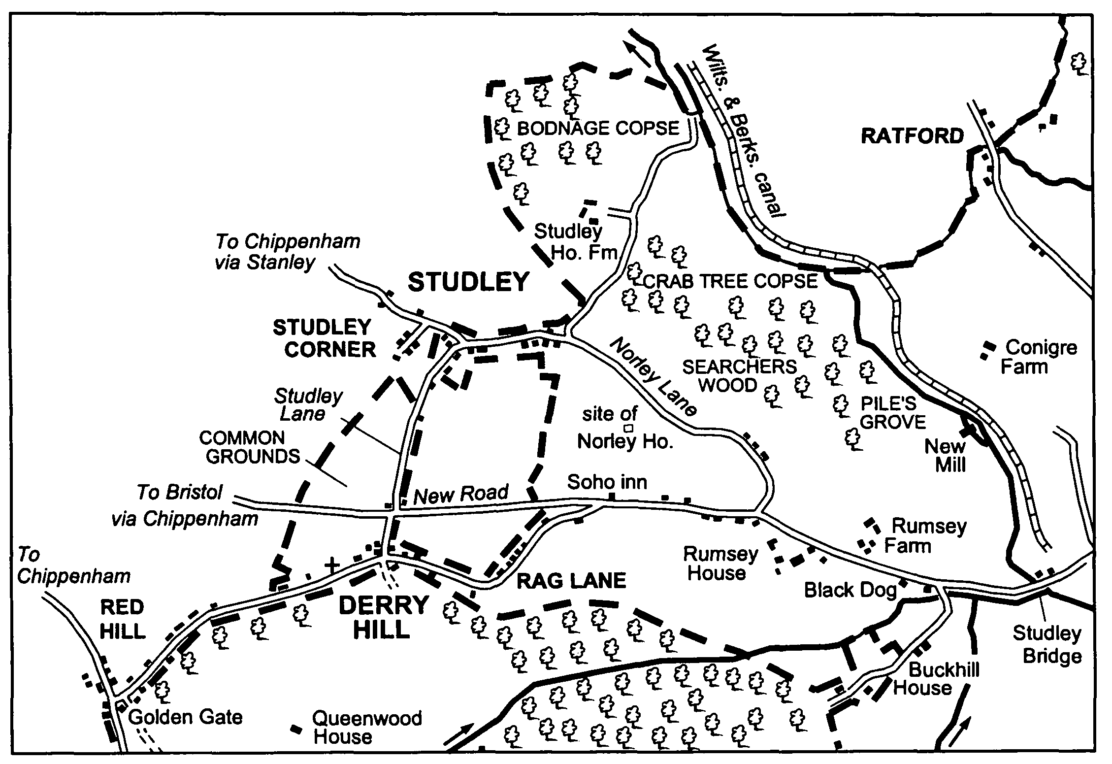
Studley
There had almost certainly been settlement at Studley by the 12th century. (fn. 163) It was probably not nucleated, Studley is not known to have had open fields, and its land was probably assarted from Chippenham forest. (fn. 164) When a new boundary for the forest was adopted in 1300 it followed the road now called Norley Lane and bisected Studley, and that part of Studley south of the road remained in the forest. (fn. 165)
Studley and Derry Hill in 1843: from the map on page 28
This sub-section deals with all the settlement at Studley, some of which lay in Bremhill and Chippenham parishes. (fn. 166) Most of the buildings stand along Norley Lane, which may have been part of the London-Bristol road in the Middle Ages, along Studley Lane, which linked Norley Lane to the later courses of the London- Bristol road at Derry Hill, and along the present course of the London-Bristol road west of Studley bridge, including the section built between 1787 and 1810. (fn. 167)
There was a manor house at Studley in 1240, (fn. 168) and in the 18th century a manor house, Studley House, stood, probably on the same site, north of Norley Lane. (fn. 169) A chapel at Studley in the earlier 13th century, presumably built by the lord of Studley manor, (fn. 170) is likely to have stood near the manor house. The house was replaced, probably between 1773 (fn. 171) and 1800 by a farmhouse built of stone rubble. The farmhouse, Studley House Farm, was given an L plan by an early 19th-century extension and, for reasons which are obscure, bears a date stone for 1875. A stone barn of the late 18th or early 19th century and 20th-century farm buildings stood near the farmhouse in 1999. Norley House, south of Norley Lane, was apparently another large house in the 18th century. (fn. 172) It was occupied as two houses in 1843 and had been demolished by 1885. (fn. 173) East of Norley House a mill stood on the Marden from the 17th century or earlier to the 20th. (fn. 174)
The name Studley came to be applied only to the group of buildings at the junction of Norley Lane and Studley Lane. Only one farmstead is known to have stood there, (fn. 175) and in the 18th century some of the buildings were apparently cottages which had been erected on the verges of the lanes. (fn. 176) In the 19th century some houses and cottages a little west of the junction and in Bremhill parish, most apparently not of high quality, were said to stand at Studley Corner. (fn. 177) A nonconformist chapel was built near the north end of Studley Lane in 1855. (fn. 178) The oldest building at Studley in 1999 was a short row of cottages, of stone and thatch and apparently 17th-century, standing beside Studley Lane. A thatched house apparently of the 18th century stood at the east end of the village in 1999, when a house built in the earlier 18th century and extended in the 19th stood at Studley Corner. The other houses and cottages were 19thor 20th-century. A pair of estate cottages was built at the east end of the village in 1888 (fn. 179) and a terrace of four cottages at the west end before 1885. In the middle, at the junction of Norley Lane and Studley Lane, a stone farmhouse, another house, and a pair of estate cottages were built in the 19th century, and in Studley Lane a pair of stone estate cottages was built between 1843 and 1885. (fn. 180) A pair of 19th-century cottages and a 19th-century house survive at Studley Corner. In the 20th century 13 houses and bungalows were built along the south side of Norley Lane and c. 25 elsewhere in the village.
East of Studley village two houses were standing near the east end of Norley Lane in 1728, (fn. 181) and a small group of buildings there in 1773 may have been called Studley Hill. (fn. 182) None of the buildings standing in the 18th century has survived. The course of Norley Lane near its east end was apparently altered between 1820 and 1843, and by 1843 a house, a pair of cottages, and a terrace of four cottages had been built beside what was apparently the new course. (fn. 183) Nearby four pairs of council houses were built c. 1930 (fn. 184) and another four pairs c. 1951. (fn. 185) Several other houses, including a pair of estate houses dated 1926, were built along the east part of Norley Lane in the 20th century.
Beside the London road between Studley bridge and the junction with Norley Lane the principal house of an estate called Rumsey's was standing in 1728 and may have occupied its site on the north side of the road from the 16th century or earlier. In 1728 a farmstead on the estate stood a little west of it on the south side of the road. About 1800 Rumsey House, a new principal house, was built in place of that farmstead, and from then or earlier the house on the north side of the road was a farmhouse, Rumsey Farm. (fn. 186) On the south side and nearer to Studley bridge the Black Dog inn was open in 1745 and 1848 but apparently not in 1855 (fn. 187) or later. The inn gave the name Black Dog Hill to that section of the London road. It occupied an earlier 18th-century house of stone rubble and stone slates which survived in 1999. Off the south side of the London road and near Buck Hill the principal house on a small freehold estate was standing in 1728; it was replaced by Buckhill House in the late 18th century or early 19th. (fn. 188) At the junction of the London road and the road to Buck Hill a pair of lodges at an entrance to the park of Bowood House was built in the mid or later 19th century. (fn. 189) On the site of the railway bridge over the east part of Black Dog Hill a Cor-ten steel footbridge with a walkway suspended from a bow-string truss was built in 1999-2000 to designs by Mark Lovell Design Engineers. (fn. 190)
Along the London road west of its junction with Norley Lane cottages stood on the verge on the south side, and two tenements stood on the north side, in 1728. (fn. 191) The cottages were replaced by two short rows of cottages built in the 19th century. On the north side of the road an 18thcentury thatched cottage survived in 1999, as did a pair of stone estate cottages dated 1868. (fn. 192) Further west, where the section of the London road built between 1787 and 1810 diverges from the old section via Rag Lane and Red Hill, (fn. 193) the Soho inn had been opened by 1830 (fn. 194) and was open in 1999. It occupies a building of the later 18th century. The new section of road was still called New Road in 1999. On the north side of it, a little west of the inn, a pair of estate cottages was built of stone in the mid 19th century and a pair in domestic revival style in 1892. (fn. 195)
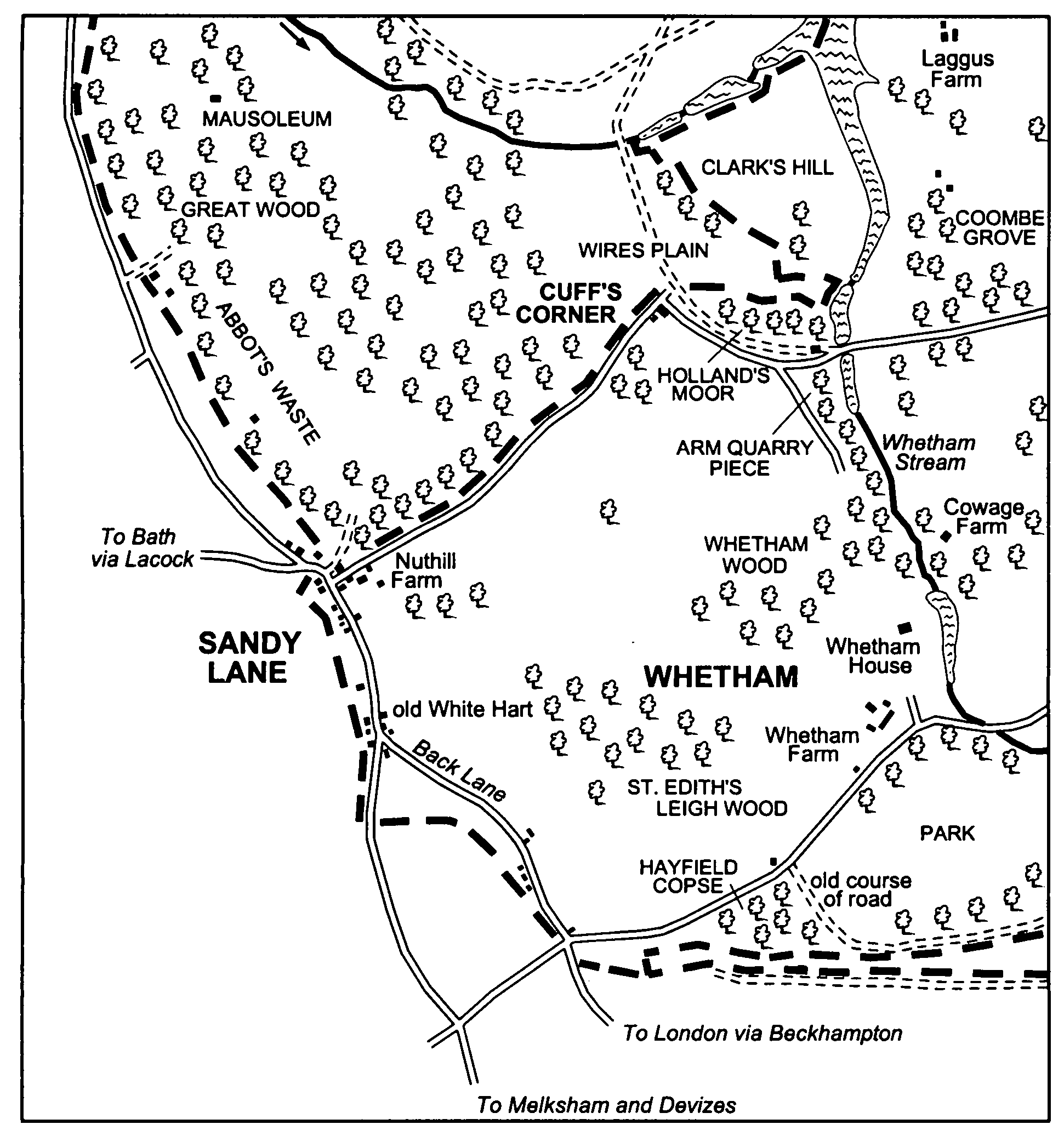
Whetham and Cuff's Corner
West of the Whetham stream, well wooded, and immediately south of a wooded part of Chippenham forest, (fn. 196) Whetham manor and the estates called Nusterly and Nuthill were probably assarted from the forest. (fn. 197) The new boundary adopted for the forest in 1300 followed the Calne-Bath road from the Whetham stream westwards via Cuff's Corner to the north end of Sandy Lane, (fn. 198) and from c. 1618 it was the boundary between those estates and Bowood park to the north. (fn. 199) A manor house, a farmstead, and a mill were built on Whetham manor, and a farmstead was built on the Nuthill estate. (fn. 200) Other settlement on land bounded by the Whetham stream, the Calne to Heddington Wick road at Broad's Green, the Roman road west of Broad's Green, the old London-Bath road through Sandy Lane, and the Sandy Lane to Cuff's Corner road (fn. 201) stood mainly along the roads at Cuff's Corner and Sandy Lane. (fn. 202)
The manor house was standing in the early 15th century or earlier, and Whetham House, built in the 17th century, stands on what was probably its site. (fn. 203) In 1728 Whetham House stood in extensive formal gardens, and a park lay south of it. The mill stood north-east of Whetham House, and Whetham Farm south. Whetham House was approached from the north by a drive from Cuff's Corner and from the south by a road running east from the London-Bath road and dividing into a drive to the house and a road skirting the park to the south and joining the Heddington Wick road at Broad's Green. (fn. 204) The road around the park may have replaced a more direct road when the park was made or extended. In 1790-1 a new section of turnpike road, partly following the southern approach to the house and perhaps on the course of such an earlier and direct road, cut the park off from the house, and buildings south-east of the house were probably demolished; the buildings were new in 1728 and were probably farm buildings. After the park of Bowood House had been enlarged to the southeast, and the lake made in the park, part of the northern approach, and a road built east of the lake in 1774, were used to replace the old roads between Cuff's Corner and Calne; in 1790-1 that new course, and the old course between Cuff's Corner and Sandy Lane, went out of public use as a road. (fn. 205)
Whetham and Sandy Lane in 1843: from the map on page 28
The farmhouse of Whetham Farm was rebuilt in the earlier 19th century, probably in the 1830s or 1840s. It is a tall house of squared ironstone and on a U plan; its main front is of three bays, is of two storeys and a half, and has casement windows under segmental heads. A barn probably contemporary with the house is faced in brick; other buildings on the site in 1999 were 20th-century. Beside the turnpike road south-west of Whetham Farm a pair of estate cottages was built c. 1905. (fn. 206)
Nuthill Farm was standing in 1728 on its present site beside the road from Sandy Lane to Cuff's Corner. (fn. 207) A stone and red-brick farmhouse mainly of the 18th century stood there in 1999; stone barns around a yard were not then used for farming.
There had been settlement at Cuff's Corner by 1709, (fn. 208) and in 1728 the settlement consisted of a small farmstead and 12 or more buildings, almost certainly squatters' cottages, along the Calne-Bath road where it ran along the boundary of Bowood park. (fn. 209) Whether there had been settlement there before the forest was inclosed c. 1618 is uncertain. All the buildings except those of the farmstead had been removed by 1817: (fn. 210) they were presumably demolished in the 1790s after the road went out of public use as a road. (fn. 211) In 1999 buildings, including a small stone house built c. 1800, remained on the site of the farmstead, which was apparently not much used for farming in the 20th century. (fn. 212)
Whitley
In the north part of Calne parish Whitley may have been a small village in the earlier Middle Ages. (fn. 213) If so, it presumably stood on or near the site of Upper Whitley Farm, which was the larger of the only two farmsteads on Whitley's land in 1728. (fn. 214) It is possible, but not likely, that Whitley had a chapel in the 14th century. (fn. 215) The farmhouse of Upper Whitley (later Whitley) Farm was rebuilt in stone and in Tudor style in the mid 19th century; farm buildings mainly of the 20th century stood near it in 1999. At the second farmstead, Lower Whitley Farm, in 1989 the farmhouse was demolished and a new one was built on a nearby site. (fn. 216) A pair of small estate cottages of stone was built west of Upper Whitley Farm between 1843 and 1885. (fn. 217)