An Inventory of the Historical Monuments in the County of Northamptonshire, Volume 3, Archaeological Sites in North-West Northamptonshire. Originally published by Her Majesty's Stationery Office, London, 1981.
This free content was digitised by double rekeying. All rights reserved.
'Woodford-cum-Membris', in An Inventory of the Historical Monuments in the County of Northamptonshire, Volume 3, Archaeological Sites in North-West Northamptonshire(London, 1981), British History Online https://www.british-history.ac.uk/rchme/northants/vol3/pp201-204 [accessed 30 April 2025].
'Woodford-cum-Membris', in An Inventory of the Historical Monuments in the County of Northamptonshire, Volume 3, Archaeological Sites in North-West Northamptonshire(London, 1981), British History Online, accessed April 30, 2025, https://www.british-history.ac.uk/rchme/northants/vol3/pp201-204.
"Woodford-cum-Membris". An Inventory of the Historical Monuments in the County of Northamptonshire, Volume 3, Archaeological Sites in North-West Northamptonshire. (London, 1981), British History Online. Web. 30 April 2025. https://www.british-history.ac.uk/rchme/northants/vol3/pp201-204.
In this section
68 WOODFORD-CUM-MEMBRIS
(OS 1: 10000 a SP 55 SW, b SP 55 SE)
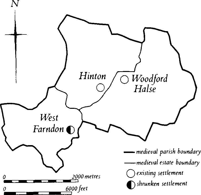
Fig. 149 Woodford-Cum-Membris Medieval settlements and estates
The parish covers about 1100 hectares and is bisected by the R. Cherwell, here flowing in a narrow steep-sided valley cut into the underlying Middle Lias Clays between 120 m. and 135 m. above OD. On either side of the river the land rises across undulating clayland to a number of rounded hills, some of which are capped by glacial deposits, or are formed by outcrops of Northampton Sand. The name of the parish comes from the uniting of three separate medieval settlements each with its own land unit, the boundaries of which are partly shown on the Tithe Map of 1840 (NRO). Woodford itself lies E. of the Cherwell on a high N.-facing spur, and Hinton stands immediately S.W. of it on the opposite side of the river on lower ground. Further S.W., also W. of the Cherwell, is West Farndon (2). Although the latter is now only a hamlet of some eight dwellings, the earthwork remains around it suggest that it was once much larger. To the S. of Woodford village is a flight of strip lynchets (3), a feature of medieval cultivation rare in Northamptonshire.
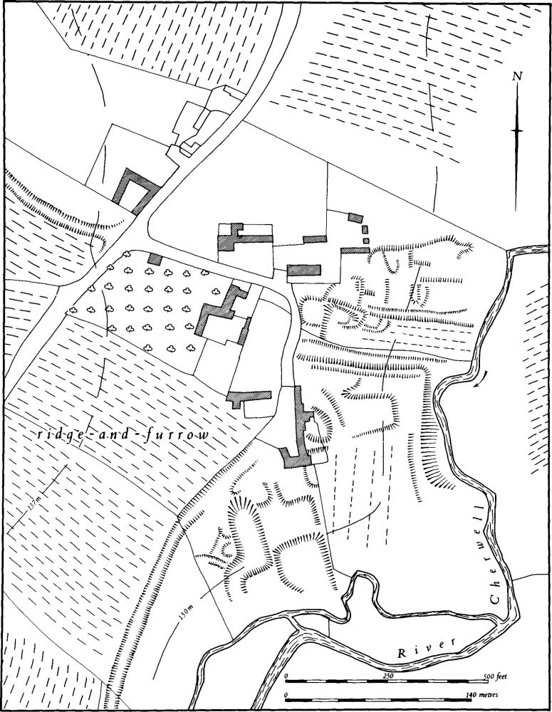
Fig. 150 Woodford-Cum-Membris (2) Settlement remains at West Farndon
Prehistoric and Roman
Worked flints, including scrapers, and pot-boilers have been found in the S.W. of the parish (SP 51555142; OS Record Cards).
a(1) Roman settlement (?) (SP 524514), W. of West Farndon, on Northampton Sand at 160 m. above OD. Sherds of 2nd and 3rd-century pottery have been found over a small area (BNFAS, 3 (1969), 2).
Medieval and Later
A 14th or 15th-century ampulla, inscribed 'Our Lady of Walsingham' was found in the W. of the parish (SP 531528; OS Record Cards; Warwick Museum).
a(2) Settlement remains (SP 530513; Figs. 149 and 150), formerly part of West Farndon, lie immediately E.S.E., S. and W. of the existing hamlet, on land sloping E. to the R. Cherwell, on clays and silts at 127 m. above OD.
The settlement is first recorded in Domesday Book when it was divided between two small manors, each with a recorded population of two (VCH Northants., I (1902), 324, 330). Later population figures are combined with the other two villages in the parish and are therefore of little value. All the earthworks are the remains of settlement already abandoned by 1840 (NRO, Tithe Map). The small single street of the hamlet can be seen once to have been part of a through road running N.W.–S.E. To the N.W. of the hamlet this road survives as a shallow hollow-way only 0.5 m. deep curving up the hillside towards Byfield (SP 527514). To the E. of the hamlet it can be traced down to the R. Cherwell as a similar hollow-way, but no trace remains to the E. of the river. On either side of the hollow-way above the river are slight scarps and banks indicating that at least three houses and closes lay on its N. side and perhaps three buildings on its S. Immediately to the S. a hollow-way or ditch up to 2 m. deep runs down the hillside but it is not clear whether this is an original feature. To the S. of this ditch, in a field ploughed and returned to grass, are the slight remains of a sub-rectangular enclosure and some irregular depressions.
Further W. and S. of the hamlet are several scarps, the lowest of which is cut back into the valley side, all forming a rectangular plan. To the W. is a deep marshy depression, also cut back into the hillside. In 1840 this field was known as Pool Close. Above it to the N. are the mutilated remains of another hollow-way running S.W. This can be traced on air photographs and partly on the ground for some 320 m. to the S. where it meets the R. Cherwell (RAF VAP CPE/UK/1994, 4101–2).
(3) Cultivation remains (Fig. 151). The common fields of Woodford Halse were enclosed by Act of Parliament of 1758. Ridge-and-furrow of these fields remains on the ground or can be traced on air photographs over most of that part of the parish which must have belonged to Woodford. Around Woodford Hill (SP 554523) there appears to be no ridge-and-furrow, but this may be, in part, due to modern destruction. Traceable ridge-and-furrow is mainly arranged in interlocked and end-on rectangular furlongs except along the N.E. parish boundary where some furlongs are triangular to enable the ridges to run across the contours. Ridge-and-furrow survives in especially fine condition S. of the village (around SP 540518 and 542520). To the N.E. of the village (at SP 548531) the modern allotments have been laid out on the pre-existing ridge-and-furrow and, as a result, have uneven widths and a reversed-S curve.
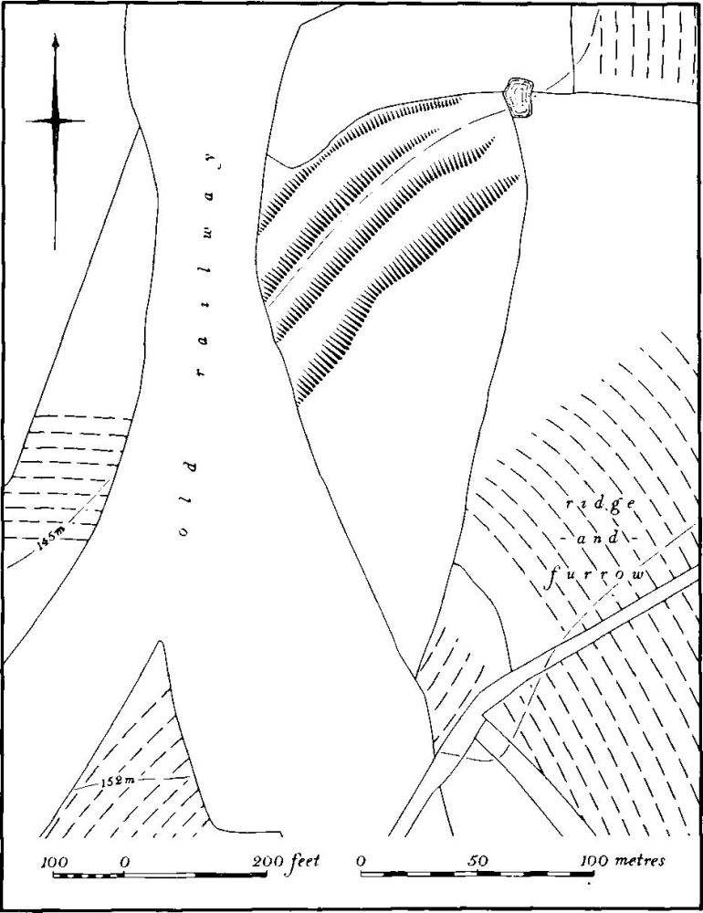
Fig. 151 Woodford-Cum-Membris (3) Strip lynchets
Immediately S. of the village, on a steep N.W.-facing hillside of Upper Lias Clay, is a flight of strip lynchets (Fig. 151), a rare survival in Northamptonshire, which consists of three contour strip lynchets, curving round the slope, with risers up to 2.5 m. high and treads up to 10 m. wide. At their E. ends they run up on to the adjacent hillside, but to the W. they are truncated by the railway cutting made in 1896–7. On the hillside above is normal ridge-and-furrow.
The common fields of Hinton were enclosed by Act of Parliament of 1753. The ridge-and-furrow of these fields can be traced all over the land of Hinton, where it is arranged almost entirely in rectangular interlocked furlongs, mainly with reversed-S curves. It is particularly well preserved in the N.W. of the parish (around SP 530535).
The common fields of West Farndon (2) were enclosed in 1760, also by Act of Parliament. Ridge-and-furrow of these fields exists or can be traced on air photographs over much of the land of the hamlet. Owing to the more broken landscape in this part of the parish the blocks are arranged in interlocked furlongs often of small size and irregular shape, in order to enable the ridge-and-furrow to be laid out approximately across the contours (RAF VAP CPE/UK/1994, 2152–7, 4097–104, 4154–61).