An Inventory of the Historical Monuments in the County of Northamptonshire, Volume 3, Archaeological Sites in North-West Northamptonshire. Originally published by Her Majesty's Stationery Office, London, 1981.
This free content was digitised by double rekeying. All rights reserved.
'Charwelton', in An Inventory of the Historical Monuments in the County of Northamptonshire, Volume 3, Archaeological Sites in North-West Northamptonshire(London, 1981), British History Online https://www.british-history.ac.uk/rchme/northants/vol3/pp43-47 [accessed 30 April 2025].
'Charwelton', in An Inventory of the Historical Monuments in the County of Northamptonshire, Volume 3, Archaeological Sites in North-West Northamptonshire(London, 1981), British History Online, accessed April 30, 2025, https://www.british-history.ac.uk/rchme/northants/vol3/pp43-47.
"Charwelton". An Inventory of the Historical Monuments in the County of Northamptonshire, Volume 3, Archaeological Sites in North-West Northamptonshire. (London, 1981), British History Online. Web. 30 April 2025. https://www.british-history.ac.uk/rchme/northants/vol3/pp43-47.
In this section
16 CHARWELTON
(OS 1: 10000 a SP 55 NW, b SP 55 NE, c SP 55 SW, d SP 55 SE)
The parish, covering some 940 hectares and of irregular shape, lies across the valley of the R. Cherwell. The river rises in the N.W. and flows S.E. in a broad open valley from 175 m. to 135 m. above OD. The undulating land beyond is almost entirely on Jurassic clays with small areas of glacial sands and gravels overlying these. In the extreme S., S.W. and N. of the parish the land rises to steep-sided, rounded hills of Northampton Sand, some over 210 m. above OD. Nothing of prehistoric or Roman date is known from the area and the main interest lies in the existence of the two villages, Church Charwelton (1), now deserted, and Upper Charwelton (3) (Fig. 13). Both seem to have suffered as a result of enclosure for sheep in the late 14th or early 15th century. The number of ponds in the parish (2), (4) and (5), apparently for both fish and wild fowl and probably of late medieval or post-medieval date, is also notable.
Prehistoric
There is said to have been a tumulus, destroyed in the early 19th century, at around SP 540563 (Archaeologia, 35 (1853), 394). The site is covered by ridge-and-furrow and there is no sign of a mound at this point. The reference may be a misplacement and misinterpretation of the mill mound (6). The same article (Archaeologia, ibid.) refers to an undated burial 20 m. to the N.W.
Medieval and Later
a(1) Deserted village of Church Charwelton (SP 544554; Figs. 13 and 39), on the N.E. side of the R. Cherwell on clay between 140 m. and 152 m. above OD. It was called Church Charwelton because the parish church, which still-stands, was located there and to distinguish it from the village of Upper or Over Charwelton (3) which lies 1200 m. up stream. The two villages are combined in most of the national taxation records so that it is almost impossible to ascertain the population of either at any one time.
In 1086 Charwelton was divided into four manors with a total recorded population of eleven (VCH Northants., I (1902), 319, 324, 326 and 331). It is possible that one of these manors, belonging to Thorney Abbey and with a recorded population of two, was part or all of Upper Charwelton and therefore the maximum recorded population of Church Charwelton could be nine. The village was mentioned by name in the Nomina Villarum of 1316. In 1491 John Rous (T. Hearne (ed.), Historia Regum Angliae (1745), 122–3) recorded that Church Charwelton was in danger of depopulation and Bridges (Hist. of Northants., I (1791), 36), writing in the early 18th century, also claimed that the village was 'in great measure depopulated at this time'. Bridges said that the village was deserted in the 15th century because of the civil war of the period, but in fact it is far more likely that enclosure for sheep led to its final abandonment. In 1417 Thomas Andrews, a merchant, acquired a small estate in the parish and later he or his son, another Thomas, leased most of the rest of the land held there by Thorney and Bittlesden Abbeys. By 1547 the third Thomas Andrews kept 1200 sheep in the parish, another 500 sheep were owned by the Knightley family of Fawsley and a further 300 by another freeholder (K. J. Allison et al., The Deserted Villages of Northants. (1966), 37). The whole site was certainly abandoned by 1847 (NRO, Tithe Map) when it was known as Home Close and belonged to the still-surviving Charwelton House.
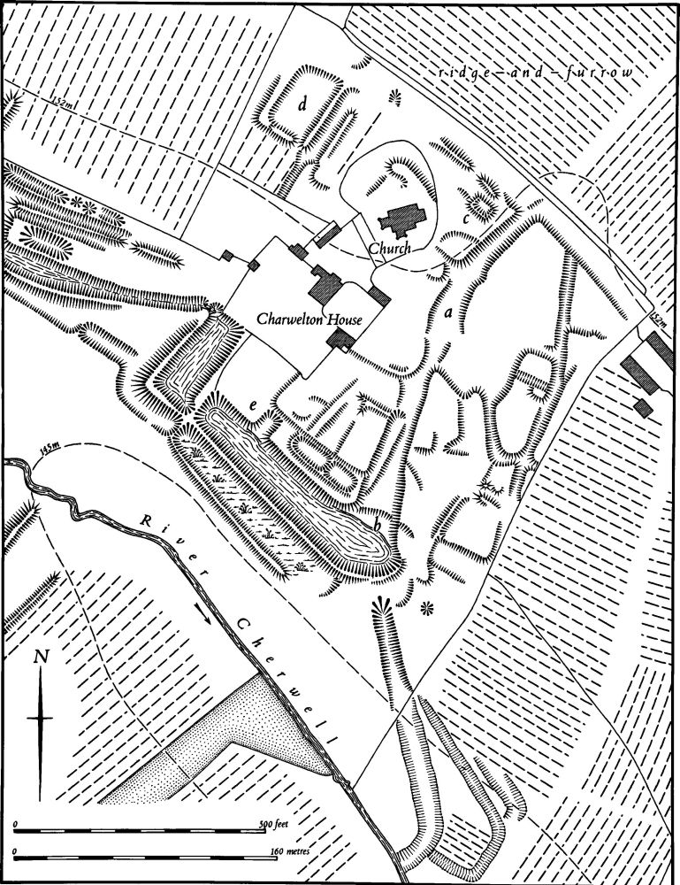
Fig. 39 Charwelton (1) Deserted village of Church Charwelton, (2) Ponds
The remains of the village lie S. and S.E. of the isolated church and Charwelton House and the main feature is a broad hollow-way ('a' on Fig. 39) only 0.5 m.–1 m. deep, which runs roughly N.–S. in a broad curve. As this nears the R. Cherwell it is cut by the most south-westerly of the fishponds (2) ('b' on Fig. 39), so this pond must post-date the abandonment of the village. Below the pond the hollow-way reappears and although its S.E. end has now been destroyed by ploughing it can be traced on air photographs further S.E. until it meets the river. On either side of the hollow-way are traces of former closes, all damaged by later activity and none complete. Only one definite house-site is visible, at the N. end of the hollow-way ('c' on Fig. 39). N.W. of the church ('d' on Fig. 39) is a small rectangular pond set back into the hillside and overlying ridge-and-furrow (RAF VAP CPE/UK/1994, 3147–8; CPE/UK/1926, 2059–60; CUAP, SA55–61, AHG47–8, AKV88–9, AW041–5, AZV84–5).
a(2) Ponds (centred SP 541555; Figs. 39 and 40), lie in the valley of the R. Cherwell, immediately S.W. and N.W. of the deserted village of Church Charwelton (1), on clay at 145 m. above OD. There appear to be two distinct systems, with different functions and perhaps of different dates. The earliest is probably the pond close to the river ('a' on Fig. 40); this is a roughly triangular sunken area bounded by scarps or dams and occupied by a complex system of islands. The water to feed it entered at its N.W. end, diverted from the river along the short inlet channels, and then passed along an outlet channel which still survives in the S. corner, back into the river. The purpose of this pond and its islands is not known but it may have been for ducks or wild fowl, the islands providing an extensive refuge for nesting. Its date is unknown. On the Tithe Map of 1847 (NRO) it is described as a fishpond.
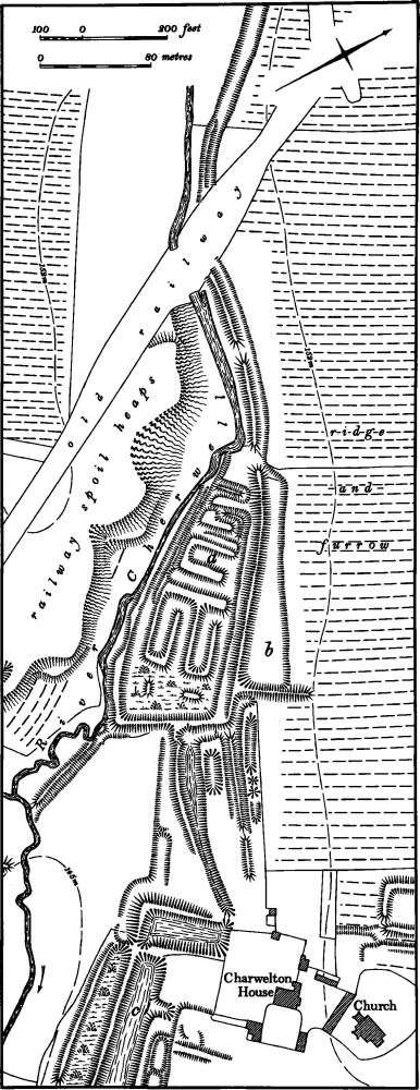
Fig. 40 Charwelton (2) Ponds
The other ponds form a more complex group. The water for them was taken from a small tributary of the R. Cherwell, 600 m. upstream, just S.W. of Upper Charwelton ('a' on Fig. 41). At this point a channel, 2 m. deep and embanked on its down-slope side, runs S.E. along the side of the valley. Beyond the point where it crosses the road to Church Charwelton the channel has been ploughed over and now remains only as a broad hollow ('b' on Fig. 41) but near the railway it returns to its original form, and on the far side of the railway embankment it continues along the valley to the first of the ponds ('b' on Fig. 40). This first pond is a long trapezoidal feature with an embankment 2 m. high on its S.W. side, above the pond with the islands already described. From it the water seems to have passed S.E. into a long narrow sinuous channel leading to a narrow slightly curved pond. An outlet at the S.E. end of this led into a small rectangular pond and thence into two large parallel ponds separated by a massive embankment 2.5 m. high ('e' on Fig. 39 and 'c' on Fig. 40). The S.E. end of the lower of these two ponds has been destroyed. The upper pond cuts the hollow-way of the deserted village of Church Charwelton ('b' on Fig. 39) and is therefore of later date. The outfall channel may have been the S. end of the hollow-way which met the R. Cherwell further S.W. since no leat is visible. The purpose of these ponds is not known, though they are likely to have been for fish. They were presumably built after the desertion of Church Charwelton and therefore not earlier than the late 15th century; they must also be later than the pond with islands described above, which they respect. The long leat to the second set of ponds was apparently out of use by 1847 (NRO, Tithe Map) for only the extreme S.E. end is shown. At the same time the larger pond, shown full of water, was called Fish Pond.
a(3) Settlement remains (SP 535562; Figs. 13 and 41), lie immediately N. of the present village of Upper or Over Charwelton, between it and Charwelton Hall, on clay and glacial gravels at 160 m. above OD. As most national taxation records combine Upper Charwelton and the now deserted village of Church Charwelton (1) it is difficult to assess the size of the village at any period. It is recorded in Domesday Book of 1086, but its population at that date is impossible to ascertain. In 1491 John Rous wrote that the village had been completely depopulated (T. Hearne (ed.), Historia Regum Angliae (1745), 122–3) and Bridges (Hist. of Northants., I (1791), 36) also said that it had suffered in the 15th century 'from the depredations of the soldiers and was in danger of being wholly destroyed', but whether the village was completely removed is not known. Presumably part of it was, probably as a result of enclosure for sheep in the 15th or early 16th centuries (see (1) above). By the late 17th century it had recovered, for the 1673 Hearth Tax Returns list 27 houses in the parish, most of which are unlikely to have been of medieval date (PRO, E179/254/14). On the Tithe Map of 1847 (NRO) the area of the remains was called Home Close.
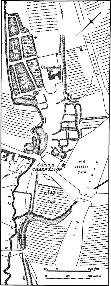
Fig. 41 Charwelton (3) Settlement remains at Upper Charwelton, (2, 4) Ponds
The remains suggest that the village was once aligned on a N.W.–S.E. axis along the R. Cherwell and then either moved to or was resettled along the main Daventry-Banbury road which crosses the river at right-angles. The earthworks are in poor condition having been damaged by quarrying, and by the construction of Charwelton station yard in 1896. They consist of a line of at least five embanked closes bounded on the N.E. by a massive scarp some 2 m. high. Their S.W. ends appear to have been cut away and they may have extended almost to the river (RAF VAP CPE/UK/1994, 3147–8; CUAP, AMS24–7, AZV78).
a(4) Fishponds (SP 533562; Fig. 41), lie in the valley of the R. Cherwell immediately S.W. of Charwelton Hall, on clay at 155 m. above OD. They consist of six roughly rectangular ponds of various sizes fed by a narrow leat from the river. They are now overgrown and in poor condition but were presumably a set of medieval stews connected with Charwelton Hall. On the Tithe Map of 1847 (NRO) they are all described as fishponds.
a(5) Ponds (SP 530555, 532558, 540553), S.W. of Upper Charwelton and W. of Church Charwelton, on clay at around 150 m. above OD, in small tributary valleys of the R. Cherwell. They vary in size but all are characterized by having small islands within them, probably for the protection of wildfowl. Their date is unknown. All are shown in their present form on the Tithe Map of 1847 (NRO) and called Fish Ponds. The same map also shows another similar pond, again with an island in it, in the S. part of the parish (SP 543542); this was destroyed by the railway (RAF VAP CPE/UK/1994, 3147–8).
a(6) Windmill mound (SP 53845599), lies E. of Upper Charwelton on the summit of a low E.–W. ridge on clay at 158 m. above OD. It is circular, 20 m. in diam. and 1 m. high, with a ditch 0.25 m. deep crossed in two places by causeways. It is surrounded by ridge-and-furrow and the ridges on the N.E. and S.W. terminate short of it indicating that the mound could be contemporary with the ridge-and-furrow. However the general pattern of the ridge-and-furrow and, in particular, the neat alignment of it on either side of the mound may indicate that the latter was erected on existing plough ridges. The mound is not shown on the Tithe Map of 1847 (NRO; RAF VAP CPE/UK/1994, 3147–8; CUAP, AZV81).
a(7) Windmill mound (SP 52555520), S.W. of the village, on Charwelton Hill, on Northampton Sand at 200 m. above OD. A low mound, now almost destroyed, marks the site of a windmill shown here on the Tithe Map of 1847 (NRO) when the area was known as Windmill Hill (RAF VAP CPE/UK/1994, 3146–7).
c(8) Windmill mound (SP 545543), in the S.E. of the parish, S.W. of Hollingwood House, on the summit of a hill of Northampton Sand at 152 m. above OD. A low mound, almost ploughed flat, with a disturbed area around it, marks the site of a windmill shown on the Tithe Map of 1847. The area was then known as Windmill Ground (RAF VAP CPE/UK/1994, 2154–5).
(9) Cultivation remains. The common fields of the parish were enclosed by agreement in 1531 (NRO, YZ 4523).
Ridge-and-furrow of these fields exists on the ground or can be traced on air photographs over most of the parish except in the extreme W., around and N.W. of Charwelton Hill Farm (SP 522555), but even here it is more likely that modern cultivation has removed all traces rather than that there was never any ridge-and-furrow. Along the valley of the R. Cherwell where it is still well preserved it is mainly arranged in end-on furlongs extending down the valley side. A similar pattern exists around the high land in the parish, especially in the N.E., around the S. and S.E. sides of Sharman's Hill (SP 542574) where the ridges radiate outwards. Elsewhere on the flatter ground interlocked rectangular furlongs are more common (RAF VAP CPE/UK/ 1994, 1155–60, 2152–6, 3145–9).
Undated
a(10) Burial (SP 539565), marked as 'site of interment' on a map in Archaeologia, 35 (1854), 394. No other details are known.