An Inventory of the Historical Monuments in the County of Northamptonshire, Volume 3, Archaeological Sites in North-West Northamptonshire. Originally published by Her Majesty's Stationery Office, London, 1981.
This free content was digitised by double rekeying. All rights reserved.
'Cottesbrooke', in An Inventory of the Historical Monuments in the County of Northamptonshire, Volume 3, Archaeological Sites in North-West Northamptonshire(London, 1981), British History Online https://www.british-history.ac.uk/rchme/northants/vol3/pp54-58 [accessed 30 April 2025].
'Cottesbrooke', in An Inventory of the Historical Monuments in the County of Northamptonshire, Volume 3, Archaeological Sites in North-West Northamptonshire(London, 1981), British History Online, accessed April 30, 2025, https://www.british-history.ac.uk/rchme/northants/vol3/pp54-58.
"Cottesbrooke". An Inventory of the Historical Monuments in the County of Northamptonshire, Volume 3, Archaeological Sites in North-West Northamptonshire. (London, 1981), British History Online. Web. 30 April 2025. https://www.british-history.ac.uk/rchme/northants/vol3/pp54-58.
In this section
20 COTTESBROOKE
(OS 1: 10000 a SP 67 NE, b SP 67 SE, c SP 77 NW, d SP 77 SW)
The parish, covering some 1150 hectares, lies on either side of a small S.E.-flowing stream, between 210 m. and 150 m. above OD. It is almost entirely on Lias Clay except for the higher areas to the S.W. and N. which are overlaid by Boulder Clay. In spite of the relatively heavy soils two Roman sites (2) and (3) and an Iron Age site (1) have been found during recent fieldwork and others undoubtedly await discovery. Of the medieval and later earthworks in the parish the settlement remains (5), though not of great interest in themselves, add to the history of the village's topography. Cottesbrooke appears always to have been two separate settlements each with its own land unit and separate field system (Fig. 14; NRO, Map of 1628). The well-preserved moated site with its enclosures (4) is usually said to be a monastic cell, but is more likely to be a small grange of Sulby Abbey.
Prehistoric and Roman
c(1) Iron Age settlement (centred SP 703759), in the N.W. corner of the parish W. of Old Covert, on clay at 145 m. above OD. Iron Age sherds were found on a dark occupation surface (Northants. Archaeol., 9 (1974), 89; CBA Group 9, Newsletter, 4 (1974), 27).
ac(2) Roman settlement (SP 700755), S.W. of (2) at 120 m. above OD. A large area of Roman pottery, building stone and patches of dark soil has been discovered (Northants. Archaeol., 9 (1974), 89; CBA Group 9, Newsletter, 4 (1974), 27).
c(3) Roman settlement (?) (SP 727751), in the N.E. corner of the parish on clay at 100 m. above OD. Air photographs (RAF VAP CPE/UK/1994, 1460–1) show a rectangular enclosure 85 m. by 30 m., orientated N.E.–S.W. at right-angles to a small stream. It is overlaid by ridge-and-furrow. On the ground the enclosing bank still survives 0.25 m. high. Roman pottery, and some other sherds of unknown date but probably Roman, have been discovered but the earthworks themselves may not necessarily be of Roman origin (BNFAS, 6 (1971), 8; Northants. Archaeol., 9 (1974), 89).
Medieval and Later
b(4) Site of monastic grange or cell (SP 690746; Fig. 48; Plate 4), lies in the N.W. corner of the parish, on Boulder Clay, on land sloping S.W. to a small stream at around 120 m. above OD. It has been said to be the site of a cell of Premonstratensian Canons, founded soon after 1155 and probably abandoned by 1291 (M.D. Knowles and R. N. Hadcock, Medieval Religious Houses in England and Wales (1953), 166; J. Bridges, Hist. of Northants., I (1791), 557). However there is no real evidence for a true cell ever having been there and the site is more likely to have been merely a grange or farmstead of Sulby Abbey. The land, called Kalender or 'Kayland', was given to Sulby Abbey by one William de Buttivillar, apparently soon after the foundation of the abbey in 1155. No other details of its history are known.
The main feature of the earthworks is a small Moated Site ('a' on plan) consisting of a rectangular island surrounded by a ditch 2 m. deep on the S.E. and 1.75 m. deep on the N.E. and N.W. but only 1 m. deep on the S.W. A low irregular mound in the interior may be the remains of a building. To the N.W. of the moat is a small embanked close with no visible entrance with, possibly, a second large close extending to the stream on the S.W. To the S.E. of the moat is another close with a number of interior scarps, bounded on the S. by a broad shallow trackway leading towards a rectangular sunken area S. of the moat. To the S. of the trackway is a further small ditched and embanked enclosure. There is a small rectangular pond on the S.W. side of the site ('b' on plan) with a large bank or dam on its down-slope side. This appears to have been filled by seepage of water from the hillside. To the S.E. of the pond but not connected to it is a long ditch, embanked on its S.W. side, the S.E. end of which passes into a large sub-rectangular depression ('c' on plan); the latter has largely been destroyed by modern cultivation but it was probably a fishpond (Ass. Arch. Soc. Reps., 33 (1923), 131–3; RAF VAP 540/474, 3151–2; CUAP, AGU64–5, NR64).
a(5) Settlement remains (SP 709735; Figs. 14, 49 and 50; Plate 19), lie at the S.E. end of the village around and W. of the church, on Lias Clay at about 100 m. above OD. The interpretation of the earthworks is difficult, and involves the whole history of the village's development.
The main area of earthworks, immediately W. of the church ('a' on plan), appears at first sight to be the remains of closes belonging to houses which once lined the road to the N. where part of a possible hollow-way indeed survives. This area could be interpreted as part of an original single-street village, the N. and S.E. parts of which still remain. However at least one other explanation must be considered. On the earliest map of Cottesbrooke, dated 1628, and indeed on the Tithe Map of 1839 (both in NRO; Fig. 50; Plate 19) neither the existing road nor the assumed hollow-way is shown. Both plans depict a road which left the present one at the N.E. corner of the churchyard and ran N. towards the lake or stream as it was in 1628, and then turned W. to run along the valley. After some 200 m. it swung S.W. to meet the modern road again near the last houses at the N. end of the village. The whole area of surviving earthworks, with the land now N. of the present road and occupied by the lodges to Cottesbrooke Hall, was a single field in 1628, with a pond on its N. side and a dove-cot N. of the church on the site of the present ice-house mound. By 1839 this field had been sub-divided into closes and two of the boundary hedges shown on the Tithe Map are marked by low scarps on the ground today. The ponds still existed but the dove-cot had disappeared and had been replaced by two buildings nearby; another building stood to the N. of the pond. The general area was then known as Horse Close. On a later map (NRO, said to be of 1874 but in fact made before 1858) the area is shown as a single field called Horse Close, but without pond and buildings. In 1858 (map in NRO) the old road had been abandoned and the present road cut across the site.
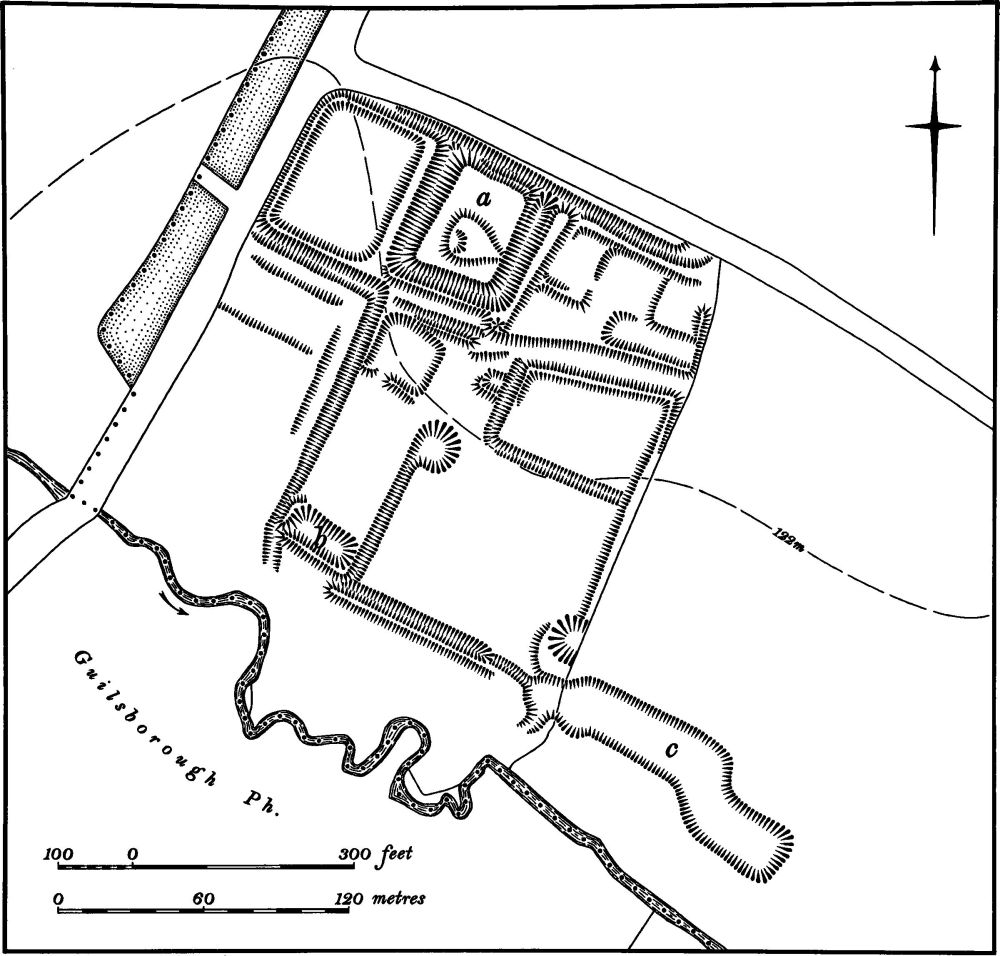
Fig. 48 Cottesbrooke (4) Site of monastic grange
It is thus possible that the surviving earthworks are no more than the remains of old paddocks and subsequent quarrying, all of which took place after 1628 and which had mostly been abandoned by 1839. If this is so then Cottesbrooke village was not originally of single-street type, but consisted of two separate settlements and is an example of a polyfocal village (Med. Arch., 21 (1977), 189). Whether this double-focus settlement existed at an early date is not known. The manorial boundary apparent on the 1628 map may indicate the division between the estates of the two settlements (Fig. 14). On the ground little remains in the area of the features shown on the early map apart from the earthworks immediately W. of the church ('a' on plan). The original road near the stream does not survive, as the construction of later gardens and the hall drive and especially the dredging of material from the lake has removed all trace. One low scarp, probably the side of the pond on the N. side of Horse Close, exists.
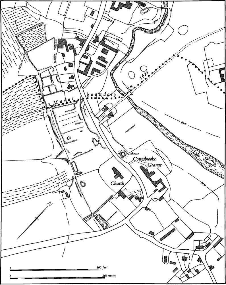
Fig. 49 Cottesbrooke (5) Settlement remains
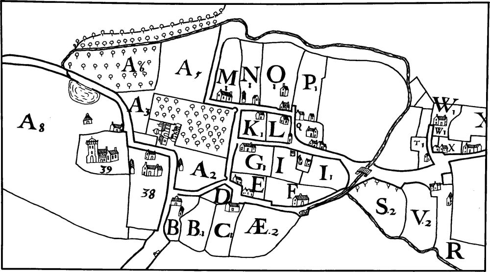
Fig. 50 Cottesbrooke (5) Plan of village in 1628 (from a map in NRO)
Immediately S.W. of the last houses in the N.W. part of the village ('b' on plan) are the remains of former closes and paddocks which presumably once belonged to houses there.
The E. part of the village underwent major changes in the 19th century but no earthworks bear witness to this. In 1628 the area was rather rectilinear in layout with a large number of houses scattered along its lanes. By 1839 this pattern had been much modified, partly by shrinkage but largely by the encroachment of the park from the N. Soon afterwards there were further alterations as the 1858 map shows and later in the 19th century most of the area was altered again and the kitchen gardens of the hall were laid out across it. At the extreme E. end of the village on both sides of the road, E. and S.E. of Home Farm (SP 717735), is a series of small rectangular enclosures bounded by low banks and scarps. These may represent another part of the village, but the area was already devoid of occupation by 1628 (CUAP, AZU16).
d(6) Garden remains (SP 709741; Fig. 51), lie immediately N.W. of Cottesbrooke Hall on land sloping N.W. towards the stream, on Lias Clay at around 100 m. above OD. John Langham, a London merchant, bought Cottesbrooke in 1637. Between 1702 and 1712 his grandson Sir John Langham built the present hall on a new site well away from the village (Pevsner, Northamptonshire (1961), 160–1). The remains of the garden are of such a form that they must date from the early 18th century and are thus probably contemporary with the house. Later in the 18th century the area around the hall was emparked and landscaped and the original gardens abandoned. This was carried out before or around 1770–80, the date of the bridge across the lake and the lodge gates (Pevsner, op. cit.).
The earthworks, though fragmentary, fall into three parts. The main section ('a' on plan), consisting of a long rectangular area, cut down into the sloping ground, and thus edged by two parallel scarps 1.5 m. high, is certainly the remains of the early 18th-century gardens. At the N.W. end, close to the stream, are the remains of a small pond which was clearly once much larger. To the S.E. the scarps turned and presumably opened out into a formal garden fronting the hall.
To the N.E. is a long bank ('b' on plan) up to 1 m. high with a flat top. It extends across the park from near the stream to a point N. of the hall, crossing and thus blocking an earlier hollow-way which can be traced to the S.E. and N.W.; its date and function are unknown. On the N. side of the bank, and within the bend of the hollow-way, is a large circular mound ('c' on plan) up to 4 m. high, much disturbed by later trees, which may be part of the original garden layout.
(7) Cultivation remains. The date of the enclosure of the common fields within the parish is not known, though certainly the whole of the S.E. part (Fig. 50) was already divided into hedged fields by 1628 (Map in NRO) and the N.W. part by 1841 (NRO, Tithe Map; Plate 19). It is possible that the whole parish was enclosed by the early 17th century though there is no proof of this nor indeed of whether there were two field systems attributable to the two apparently separate medieval settlements there (5). Ridge-and-furrow of these fields exists on the ground or can be traced on air photographs over much of the parish and is particularly well preserved within Cottesbrooke Park. It is arranged in mainly rectangular interlocked furlongs, many of reversed-S form. A number of access-ways between furlongs are visible, for example S.W. of the village (at SP 702732) and at the N.E. end of Cottesbrooke Park (SP 702742; RAF VAP CPE/UK/1994, 1373–7, 1459–65; 540/474, 3151–2).