An Inventory of the Historical Monuments in the County of Northamptonshire, Volume 3, Archaeological Sites in North-West Northamptonshire. Originally published by Her Majesty's Stationery Office, London, 1981.
This free content was digitised by double rekeying. All rights reserved.
'Badby', in An Inventory of the Historical Monuments in the County of Northamptonshire, Volume 3, Archaeological Sites in North-West Northamptonshire, (London, 1981) pp. 7-12. British History Online https://www.british-history.ac.uk/rchme/northants/vol3/pp7-12 [accessed 26 April 2024]
In this section
4 BADBY
(OS 1: 10000 a SP 55 NW, b SP 55 NE, c SP 56 SW, d SP 56 SE)
The almost rectangular parish of some 980 hectares is roughly bisected by the upper reaches of the E.-flowing R. Nene. In the extreme N. are three isolated hills, two capped with Northampton Sand rising to well over 180 m. above OD and the centre one overlaid by glacial gravel rising to 165 m. above OD. From there the land slopes gently across Lias Clays to the R. Nene, here flowing at about 120 m. above OD; beyond the river it rises more steeply, still on clay, to a maximum height of just over 180 m. on Badby Down, an E.–W. ridge capped with Northampton Sand. In the extreme S.E. of the parish is another isolated hill known as Arbury Hill which is of strangely rectangular form and has traditionally been said to be the site of an Iron Age hill fort (2); however this is in some doubt as the assumed defences appear to be natural features. The village of Badby lies S. of the Nene on a low rounded clay hill. Its plan is complex and not fully understood (4). Much of the S. part of the parish is occupied by Badby Wood, the site of a medieval deer park (6); its boundary pale is one of the best preserved in the county. A number of minor earthworks on the periphery of the parish have been recorded in detail elsewhere and are not listed below (Northants. Archaeol., 12 (1977), 155–76).
Prehistoric and Roman
A Palaeolithic hand-axe has been found in the parish (OS Record Cards; PPS, 29 (1963), 383). A scatter of Roman pottery has been found N. of the village (SP 559598; Northants. Archaeol., 12 (1977), 211).
b(1) Flint-working site (SP 573580), just outside the S.E. corner of Badby Wood, on Northampton Sand at 165 m. above OD. A large quantity of worked flints and waste flakes has been found here (local inf.).
a(2) Supposed hill fort (SP 541587; Fig. 19), covers some 4 hectares on the summit of Arbury Hill, a flat-topped, steep-sided knoll of Northampton Sand at 217 m. above OD. The site has for a long time been regarded as fortified and indeed was first described as such in an Anglo-Saxon Charter of 944 (BCS 792). There the site is called the 'ealden burh æt Baddanbyrig' and the charter describes the Badby boundary as running along the dic to the west of the burh. The present name of the site seems relatively modern for it does not appear in the records until 1712 (PN Northants., 13). In 1830 the site was described by G. Baker (Hist. of Northants., I, 258) as having a very high rampart and 'encompassed, except at the entrance on the E. side, by a wide single trench which has been 20 ft. deep, though farming has reduced the bank'. However in 1906 (VCH Northants., II, 401–2) though the scarps on the S. and W. sides were recognised they were not accepted either as of a defensive nature or as of ancient origin. Later investigators also rejected the antiquity of the site and suggested that the banks were caused by soil-creep and that the ditches on the N. and W. were modern drains (J. Northants. Natur. Hist. Soc. and FC, 24 (1928), 188). The site has been rejected as an antiquity by the OS and was not accepted for inclusion on the Map of Southern Britain in the Iron Age. It is not now possible to determine whether there was a hill fort here as ploughing of the summit and slopes over a long period has removed most of the evidence, but the features which had the appearance of ramparts were probably natural.
The flat summit is edged by a rounded and much degraded scarp, except in the N.E. corner where a natural gulley gives the appearance of an entrance. Below this upper scarp there is a wide sloping terrace below which the ground falls steeply and this is almost certainly the feature thought of as a ditch. It appears in fact to be the junction between the Northampton Sand and the underlying Upper Lias Clay and to be formed partly from the erosion of the sandstone but also partly as a result of the geomorphological process known as cambering and valley bulging (Q.J. Geol. Soc. London, 100 (1944), 1–44). On the E. of each side of the so-called entrance are large irregular mounds, which produce a ditched effect. These are almost certainly the result of landslips from the main scarp, and indeed the origin of the S. mound is visible as a deep indentation in the scarp face above it. Other landslips exist on the hillside, especially N. of the N.E. corner.
No finds have been made on Arbury Hill except for a fragment of a flaked and polished Neolithic flint axe, said to have been found there before 1893 (NM Records; RAF VAP CPE/UK/1994, 1158–9, 1277–8).
Medieval and Later
For Saxon cemetery, sometimes said to be at Badby, see Newnham (2).
b(3) Site of moated monastic grange or manor house (SP 562591; Fig. 20), now completely destroyed, lay on the S. side of the R. Nene, N.E. of the village, on low-lying marshy ground at 107 m. above OD. The manor of Badby belonged to the Abbey of Evesham from before the Norman Conquest until the Dissolution.
The site consisted of a small rectangular area of just under 0.5 hectares, bounded by a shallow ditch except on the W. side where there was a small N.-flowing stream. It was fully excavated in 1967–9 and three major periods of construction were identified. In period I (early to mid 13th century) the moat was constructed and a series of stone buildings erected within it, consisting of a stone hall and various detached domestic buildings. A chapel and a chamber were later added, at opposite ends of the hall. In period II (14th century) bakehouses and other structures were built, the hall was altered, the chapel extended and a stable-wing added. In period III (15th to 16th century) most of the buildings except the chapel were demolished and replaced by a group of structures round a courtyard. The moat was enlarged at the same time (G. Baker, Hist. of Northants., I 1822–30), 256; BNFAS, 2 (1967), 21; 3 (1969), 19; 4 (1970), 15; Med. Arch., 12 (1968), 190; 13 (1969), 270; 14 (1970), 191).
To the E. were other earthworks now also destroyed by ploughing (RAF VAP CPE/UK/1994, 1275–6). These included a large embanked paddock N.E. of the moat (at SP563591) and, to the E., a long pond with an embanked N. side orientated E.–W., possibly a mill pond or a fishpond (SP 563590). There were also hollow-ways or tracks crossing the area from the village to the river. On the Enclosure Map of Badby (NRO, 1779) what appear to be the N. and E. sides of a very large moated site with an entrance through the middle of the E. side are shown a little to the N. of the excavated moat. At that time the whole area was known as Court Yard.
b(4) Settlement remains (centred SP 560589; Figs. 11 and 20), formerly part of Badby village, lie around and between the existing houses, on Middle Lias Clay between 120 m. and 137 m. above OD. They add to the complexity of the village plan which is in any case difficult to interpret.
The S. part of Badby consists of a loop road set on land sloping down to the N. The church with a small triangular green on the E. occupies the highest point, and the loop is divided into two unequal parts by a further lane running N.W. from the green. Outside the loop, on the N.W., is another small green. The N. part of the village, beyond the loop, is built round a large roughly rectangular green. This plan has been explained as a characteristic type of settlement in a forest environment, with the freedom to develop loops and greens unconfined by the limits of the common fields (M. W. Beresford and J. K. S. St Joseph, Medieval England: An Aerial Survey (1958), 129). However it seems that the true explanation is more complex, for example the large rectangular green to the N. of the loop with a back lane on the W. might be interpreted as a deliberately planned extension to the original village (see also Newnham (2)). In addition, on the Enclosure Map of Badby (NRO, 1779) other lanes are shown which have now fallen out of use, especially on the S.W. side of the village.
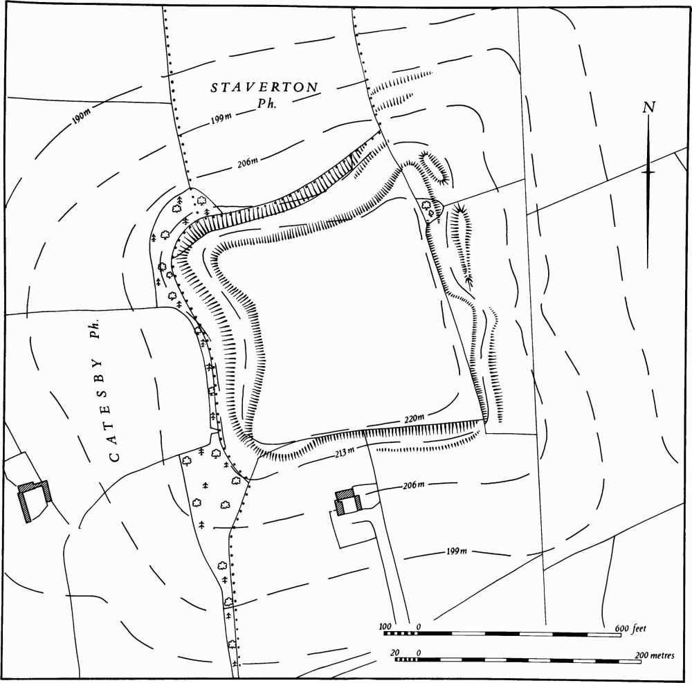
Fig. 19 Badby (2) Supposed hill fort on Arbury Hill
The earthworks associated with the village fall into two groups. To the N.E. of the church, within the N.E. half of the area contained by the loop road ('a' on plan), was another street which survived until recently as a broad hollow-way dividing this larger part of the area within the loop into two. On the E. side of this hollow-way, extending from it down the slope, were at least five or six rectangular closes bounded by banks, scarps or ditches. The area has now been built over and all the earthworks destroyed, but a large quantity of medieval pottery has been discovered in the vicinity. It consists of 13th and 14th-century types and included unglazed Potterspury and Coventry wares, part of a Lyveden ware jug and most of an onion-shaped jar of orange fabric with a green glaze and was found in association with a large area of stone flags (Northants. Archaeol., 9 (1974), 103). The hollow-way itself was marked by a band of gravel (local inf.). No building existed here in 1779 (NRO, Enclosure Map) but some of the close boundaries E. of the hollow-way still had hedges on them and the N. part of the hollow-way itself was a long narrow close. Further N.W., at the N.W. end of the back lane, are three embanked closes ('b' on plan) behind existing houses. In the N. of the village, on the W. side of the large rectangular green (SP 559591) late Saxon and 12th-century pottery has been recovered from gardens (local inf.; RAF VAP CPE/UK/1994, 1275–6).
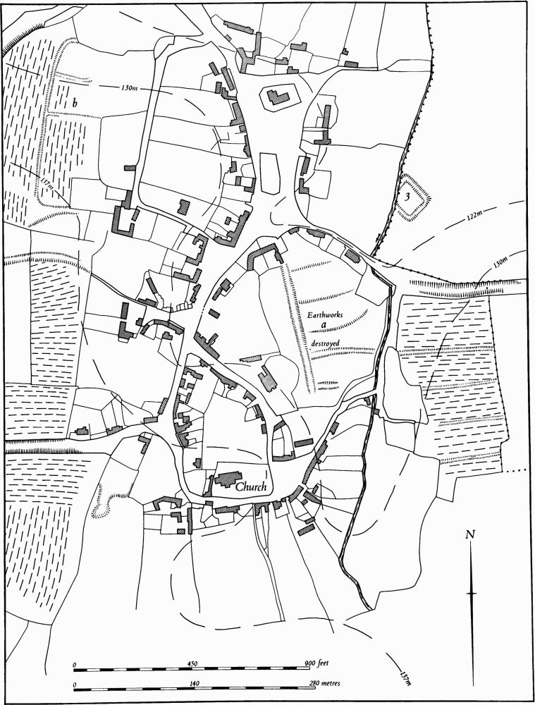
Fig. 20 Badby (3) Moat, (4) Settlement remains
b(5) Hollow-way (SP 55895782–55955801; Fig. 21), on Badby Down, along the southern parish boundary with Fawsley, cutting through the flat-topped summit of the E.–W. Northampton Sand ridge at 180 m. above OD.
The hollow-way is referred to in an Anglo-Saxon Charter of 944 (BCS 972) giving the boundary of 30 hides of land at Badby, Dodford and Everdon and is there described as the road from Fawsley to Badby. It consists of a narrow hollow-way almost 200 m. long and 1.5 m. deep. At the S. end it fades out and becomes a modern track leading down towards Fawsley Hall; at the N. end it cuts through the steep natural scarp above the edge of Badby Wood and is then blocked by a low scarp which is a remnant of the pale of the deer park (6). No trace of the hollow-way exists below the park pale as the area is a spring head and there is much marshy ground. It probably ran N. across the E. part of Badby Wood and entered the village near the church on or near the present footpath (at SP 560586) which is also deeply hollowed.
b(6) Deer Park (centred SP 565582; Fig. 21), occupies 80 hectares to the S.E. of the village, in the area now largely covered by Badby Wood. It lies on land sloping down steeply to the N. and N.E., mainly on Upper Lias Clay between 180 m. and 145 m. above OD. The park was created in 1245–6 when the Abbey of Evesham which held the manor obtained permission from the Crown to enclose Badby Wood for a park (J. Bridges, Hist. of Northants., I (1791), 20) but its later history is unknown.
Remains of the park pale survive round almost the whole circuit of the park and are among the best preserved in the county. Along the lower N. side of Badby Wood (SP559583–569586) the pale is an almost continuous bank 6 m.–7 m. wide and up to 1.75 m. high above the interior of the wood but only 0.25 m. above the higher land of the surrounding fields. It turns S. along the E. edge of the wood where it also marks the parish boundary with Newnham. At the S.E. corner of the wood (SP 572581) the pale, following the Fawsley-Badby parish boundary, leaves the wood and runs down the slope into Fawsley Park where the bank is very low and indistinct but can just be traced to a point N. of the Dower House in Fawsley Park (SP 570578). It then swings N.W. and becomes larger until, at the point where it meets the wood again (at SP 563578), it is 7 m. wide and 1.5 m. high. For some 200 m. beyond that the bank has been almost completely destroyed by ploughing which here runs to the edge of the woods. Just W. of an old sand pit the bank reappears and runs diagonally across a massive natural scarp 4 m. high which is the junction between the Northampton Sand to the S. and the Lias Clay to the N. Here the pale is 2 m. high and 7 m. wide. It reaches the bottom of the natural scarp and, turning N.W., runs along its foot. A little further on (at SP 55955801) it blocks the hollow-way (5) which clearly pre-dates the pale, though here the latter is reduced to a low scarp. Beyond, the pale continues around the edge of the wood, still below the natural scarp which increases to a maximum height of 6 m. The pale here is about 1 m. high and 8 m. wide and continues in this form until it reaches the N.E. corner of the wood.
Badby Wood is very uneven and overgrown, but there are traces of a number of low banks and scarps within it. These may be the remains of the boundaries of coppicing enclosures (RAF VAP CPE/UK/1994, 1274–6; Northants. Archaeol., 12 (1977), 155–76).
b(7) Terraced Way (SP 552586), W. of Badby village on the E. side of a deep narrow valley draining N. Air photographs (RAF VAP CPE/UK/1994, 1276–7) show what appear to be several strip lynchets, but on the ground a shallow terraced trackway can be seen, curving along the edge of the valley. It was probably an old line of the road from Catesby into Badby village.
(8) Cultivation remains. The common fields of the parish were enclosed by an Act of Parliament of 1779 (NRO, Enclosure Map), though areas of old enclosures already existed then. Ridge-and-furrow of these fields exists on the ground or can be traced on air photographs over a large part of the parish, but certain areas are completely devoid of any remains, presumably as a result of modern cultivation. Where it survives it is almost all in rectangular interlocked furlongs, often with reversed-S curves and carefully arranged so that it runs at right-angles to the contours.
Immediately E. of Badby village on a steep W.–facing slope (SP 562588; Fig. 20) there is a remarkably well-preserved furlong of ridge-and-furrow with dividing ditches between the blocks of ridges. The Enclosure Map of 1779 (NRO) shows that immediately before then most of the eastern part of the parish, as well as a small area W. of the village called Bare Hill Ground and another place near Fox Hill in the N.E. of the parish, was already divided into hedged fields (RAF VAP CPE/UK/1994, 1158–63, 1274–8).
Undated
d(9) Mound (SP 56086009), possibly a windmill mound, lies immediately W. of the Daventry-Banbury road, N. of the village on the N. side of the Nene valley, on clay at 155 m. above OD. It was recorded as a 'tumulus' in 1923 (W. Edgar, Borough Hill, (1923), 38) and was marked as such on OS maps from 1923 to 1950. A more recent record suggests that the mound was one of a former group of barrows, but no evidence for this theory exists (Pevsner, Northamptonshire, (1961), 91).
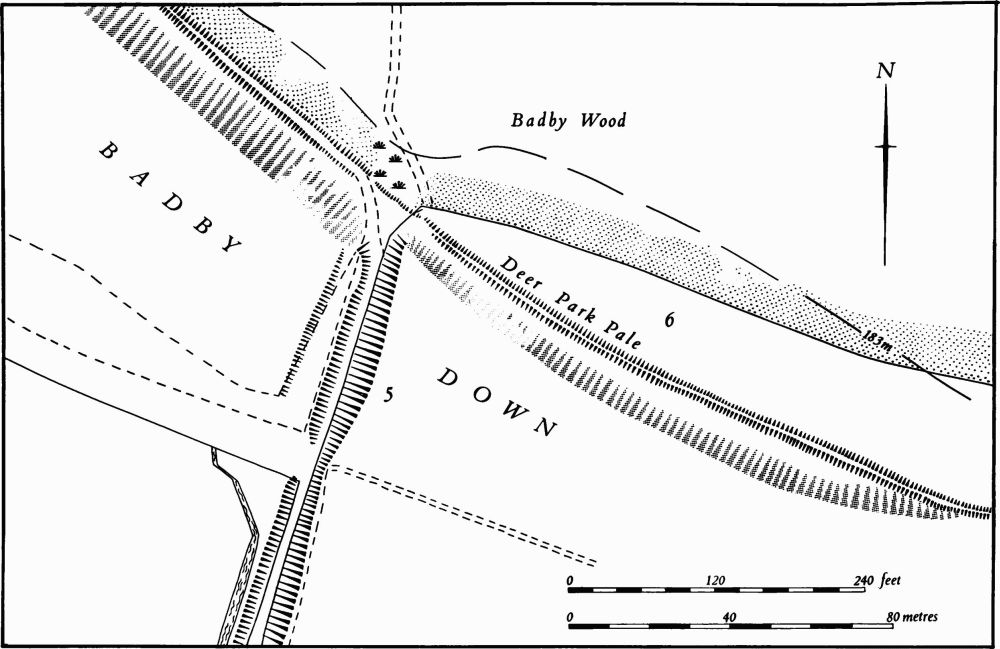
Fig. 21 Badby (5) Hollow-way, (6) Deer park
The mound is now ploughed over and only survives as a gentle rise 23 m. in diam. and 0.25 m. high (OS Record Cards).