An Inventory of the Historical Monuments in the County of Northamptonshire, Volume 3, Archaeological Sites in North-West Northamptonshire. Originally published by Her Majesty's Stationery Office, London, 1981.
This free content was digitised by double rekeying. All rights reserved.
'Sectional Preface', in An Inventory of the Historical Monuments in the County of Northamptonshire, Volume 3, Archaeological Sites in North-West Northamptonshire, (London, 1981) pp. xxiii-lv. British History Online https://www.british-history.ac.uk/rchme/northants/vol3/xxiii-lv [accessed 26 April 2024]
In this section
SECTIONAL PREFACE
TOPOGRAPHY AND GEOLOGY
The part of Northamptonshire described in this volume covers an area of some 600 square kilometres, bounded on the N. by Leicestershire and on the W. by Warwickshire. Topographically the region consists of scarp and dip-slope features based on rocks of the Jurassic period but it has been so dissected by later streams that the general impression is of rolling countryside with little visible indication of the underlying structure. Most of the area is on clays of the Lower, Middle and Upper Lias, but Northampton Sand covers the higher watersheds in the N. and N.W., caps many isolated rounded hills in the S.W. and W. and forms broad open stretches of land N.W. of Northampton around Harlestone, Church and Chapel Brampton and Boughton. Large parts are overlaid by glacial deposits including sands, gravels and clays. Except in the extreme N., N.W., W. and S. the main drainage is S.E. down the Jurassic dip-slope where a series of small streams flow towards the River Nene. In the N. a group of shorter streams flow N. to join the River Welland which rises near Sibbertoft, and in the W. and N.W. streams flow into the River Avon, which also rises in the area, near Naseby. The extreme S. is drained by the headwaters of the River Tove and the River Cherwell. None of these streams is edged by gravel deposits of any extent and most flow in broad valleys cut directly into the underlying rocks.
Apart from one or two small timbered areas such as Badby Wood, there is no woodland in the region, though the many trees in the hedges give the landscape a wooded appearance. Rivers, streams and springs everywhere provide copious water supplies; building-stone of high quality comes from the beds of limestone.
Present-day settlement is evenly spread over the whole area. In the E. most of the villages lie on Northampton Sand. Many of these are on hilltops or ridges, for example Cold Ashby, Thornby, Creaton and Spratton, as well as Draughton, Lamport, Brixworth and Pitsford. Others, for example the Bramptons and Harlestone, are on lower, flatter areas of the same formation. Further W. the villages have more varied situations. Places such as Crick and Barby are on dry patches of low-lying glacial gravel; Preston Capes, Staverton and Farthingstone are on high ground, Newnham and Badby on low clay hills and Clay Coton on alluvium in a valley bottom. In the N., the villages of Naseby, Clipston and Sibbertoft are on high land largely covered by Boulder Clay.
Daventry is the only urban area, and even this was still a small market town until recent expansion took place. Long Buckby was a medieval market centre but never became much more than a large village.
Apart from extensive workings around Brixworth, the part of Northamptonshire here under review has suffered less from ironstone-mining than the area further E. Devastation caused elsewhere, for instance in the Nene valley, by gravel-working is absent here because of the lack of gravel deposits. The region is almost entirely agricultural and, as a result of a farming economy more mixed than in east and central Northamptonshire, permanent grassland is more common. An important consequence of this is that earthworks of a variety of periods survive to a greater degree here than elsewhere.
Prehistoric and Roman Settlements (Figs. 1–10)
Compared with the east and central parts of Northamptonshire, the area covered by this Inventory is poor in known remains of the prehistoric and Roman periods; moreover the distribution of the material is too uneven and unsatisfactory for any spatial analysis. The quantity of new sites coming to light as a result of increased local fieldwork is such that the distribution maps here presented will require continual revision.
The material from this region is no less difficult to interpret than that in the areas previously described, and for the same reasons (RCHM Northants., I (1975), p. xxiv; II (1979), p. xxx. Indeed the difficulty in north-west Northamptonshire has been made the greater in some respects by the concentration of detailed fieldwork on specific periods in a few small areas. For example, the discovery of prehistoric flint-working sites in Brixworth (1–11) and of the Mesolithic site in Elkington (1) in the N. of the area adds little to our knowledge of prehistoric occupation patterns, whereas the implications would be great if similar discoveries were to be made throughout the county. The amount of work still needing to be carried out is considerable, but the evidence drawn together here and in the two previous Commission volumes on Northamptonshire implies a very much denser exploitation by man of almost every part of the landscape than used to be thought possible. It appears that the constraints of the natural environment such as heavy soils and dense woodland were more easily overcome than had previously been assumed, or were operating in a way as yet unknown to us.
In some respects the material in the Inventory is unsatisfactory, derived as it is from diverse sources over a long period of time and to very varied standards. Little is closely dated, or even recorded in an acceptable way. The relative ease with which material is recognised in field-walking may also lead to conclusions about the pattern of past settlement which may be false. For example, most of the flint-working sites listed lie on the Northampton Sand deposits, where it is easier to find them (e.g. Brixworth (1–11), Chapel Brampton (1–4, 6, 9) and Church Brampton (2–4, 9)), yet they have occasionally been recognised on heavier soils, such as Boulder Clay, for example at Chapel Brampton (11). Similarly, though most Iron Age and Roman settlements have been found on the lighter soils there are considerable numbers known on the Lias Clay deposits (Marston Trussell (1, 2), Cottesbrooke (1–3), Creaton (5–8) and Elkington (2, 5)). The evidence from air photographs too may be misleading. The light soils, especially the Northampton Sand and the glacial gravels, have revealed many remarkable complexes of cropmarks (e.g. Church Brampton (2, 8–11), Chapel Brampton (1–9) and Harlestone (1–5)) as well as individual enclosures and other features. On the much more extensive claylands, however, cropmarks are either very rare or, where recognised, are unclear and difficult to interpret. Yet such sites do occur (Kelmarsh (1, 2), Naseby (1)) and should not be ignored even though they are much less impressive than elsewhere. In addition, other sites may not be visible from the air at all.
An additional problem concerning soilmarks and cropmarks is that of distinguishing post-Roman sites from prehistoric or Roman ones. The growing evidence for a dispersed pattern of early Saxon settlement (see Saxon Remains) suggests that some sites known only from air photographs may be of this later period. Finds on the ground from one group of cropmarks at Chapel Brampton (2) indicate early Saxon occupation there, and although excavation might add to this picture, the possibility that some sites hitherto assumed to be prehistoric or Roman are in fact of Saxon date must be taken into consideration.
Few sites in the area have been excavated and not all of these have been fully published. Little can be usefully said, therefore, about the chronology, date, relationships, economy or social significance of most of them.
Prehistoric Remains
Of the prehistoric sites at present known within the area, few are datable since the fragile pottery of pre-Roman times is easily destroyed by later activity and cannot readily be found on the ground surface. A large number of the settlement sites shown clearly on air photographs as soilmarks or cropmarks but which have not produced Roman pottery are perhaps of prehistoric date. This is not certain, however, and no accurate dating evidence is obtainable without excavation; few cropmarks have any diagnostic features which enable them to be dated. Surviving earthworks of prehistoric times are extremely rare. The most notable is the vast hill fort of Borough Hill (Daventry (3)) and even this has suffered greatly over the last two centuries. The same is true of other sites which have been almost completely obliterated by modern cultivation, though they remained intact for centuries owing to their position on land which in medieval times was marginal. The enclosure at Farthingstone (3) is a good example of this.
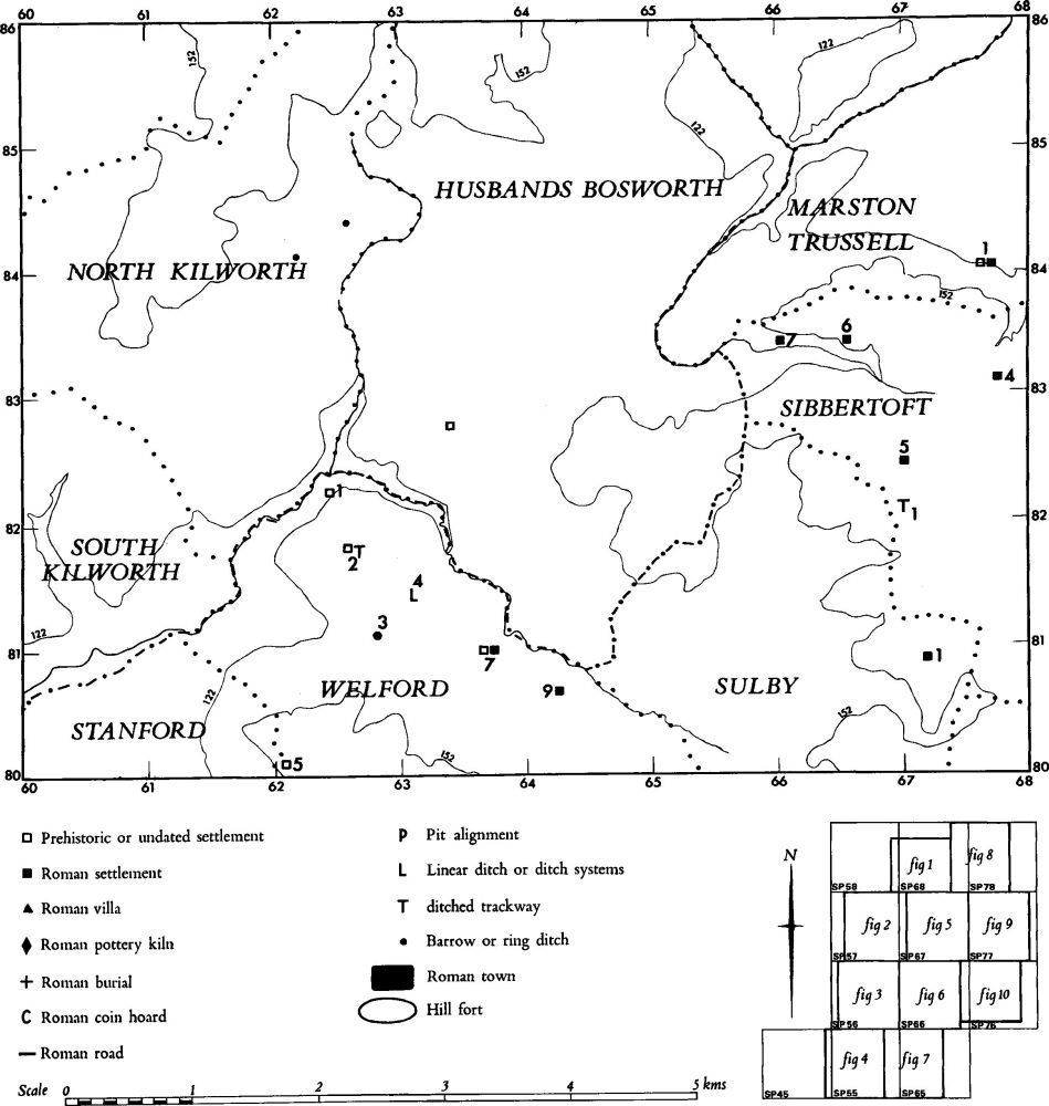
Fig. 1 Prehistoric and Roman sites and finds
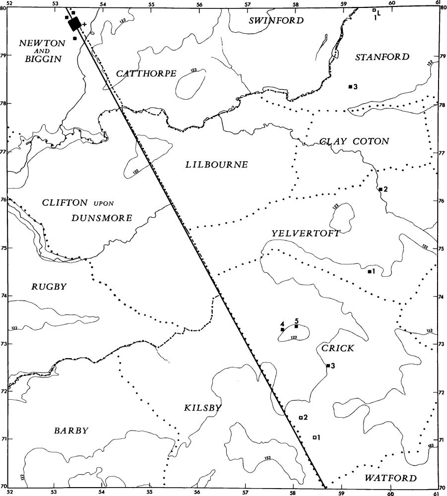
Fig. 2 Prehistoric and Roman sites and finds (for key see fig. 1)
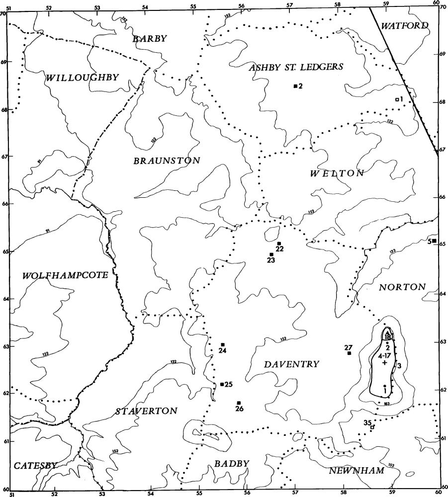
Fig. 3 Prehistoric and Roman sites and finds (for key see fig. 1)
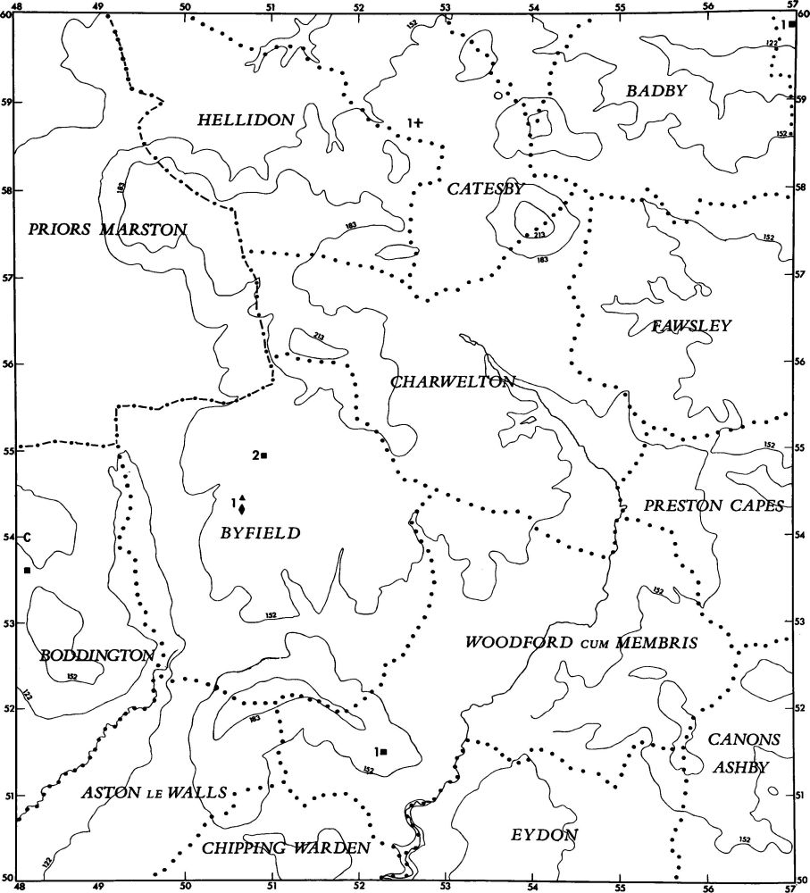
Fig. 4 Prehistoric and Roman sites and finds (for key see fig. 1)
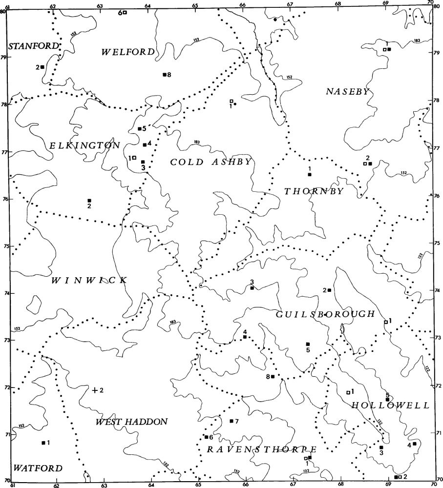
Fig. 5 Prehistoric and Roman sites and finds (for key see fig. 1)
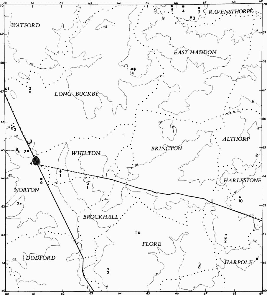
Fig. 6 Prehistoric and Roman sites and finds (for key see fig. 1)

Fig. 7 Prehistoric and Roman sites and finds (for key see fig. 1)
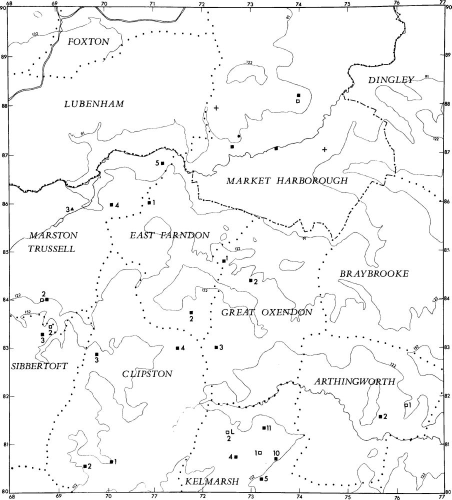
Fig. 8 Prehistoric and Roman sites and finds (for key see fig. 1)
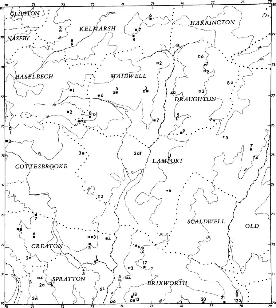
Fig. 9 Prehistoric and Roman sites and finds (for key see fig. 1)
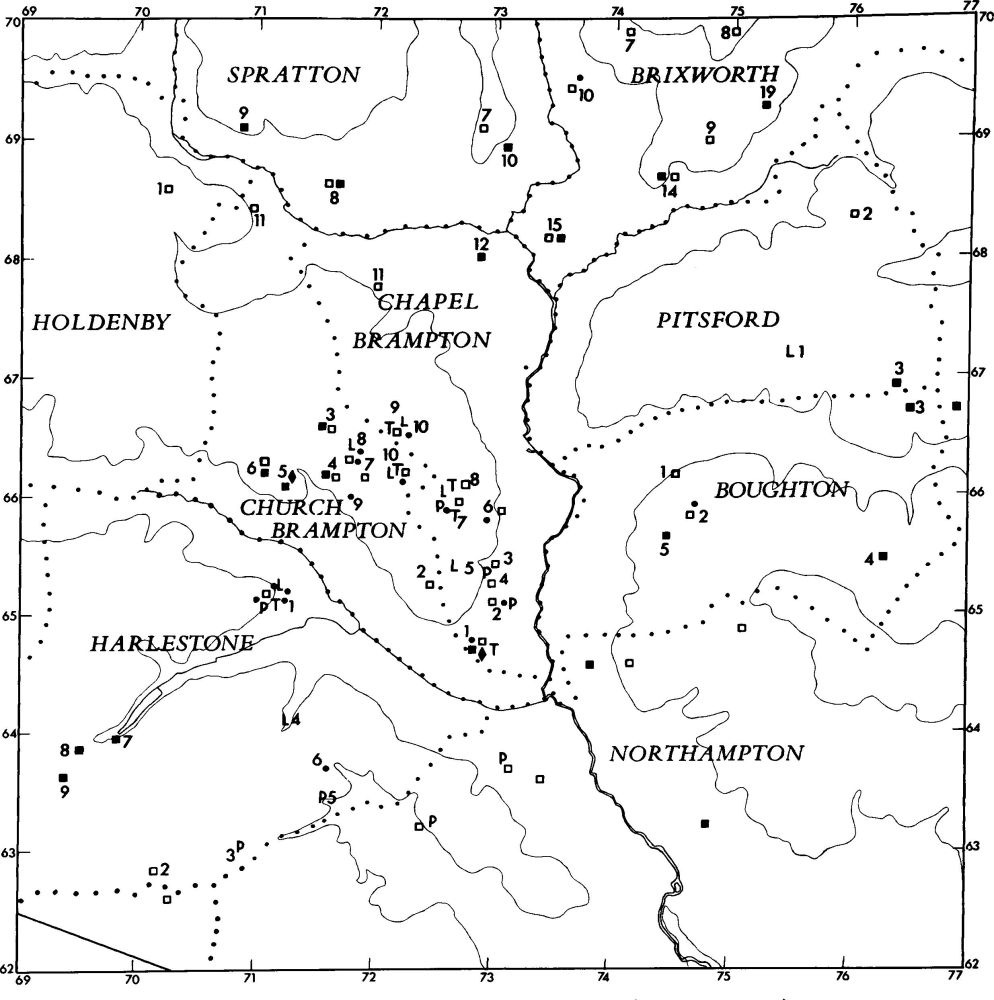
Fig. 10 Prehistoric and Roman sites and finds (for key see fig. 1)
Palaeolithic Period
Only three Palaeolithic axes are known in the area, one from Badby (p. 7) and two from Borough Hill, Daventry (p. 63). This lack of Palaeolithic material is probably related to the absence of gravel deposits.
Mesolithic Period
Until very recently little Mesolithic material had been noted in this part of Northamptonshire. Cores, said to be of Mesolithic type, are recorded from Pitsford (p. 161), Draughton (p. 75), Brockhall (p. 32) and Creaton (p. 58); an axe is listed from Flore (p. 91). However, fieldwork over the last few years has produced a small number of identifiable Mesolithic or later sites in the S. of the area, as at Brixworth (5, 8, 15). The recent discovery of a large occupation area at Elkington (1) is especially notable, for its existence casts doubt on earlier theories that Mesolithic occupation in the English Midlands was extremely limited.
Neolithic Period
Little material of definite Neolithic date is recorded from north-west Northamptonshire. Flint axes are listed from Badby (p. 8), Brixworth (p. 27), Boughton (p. 14), Daventry (p. 63), Everdon (p. 80), Farthingstone (p. 86), Flore (p. 91) and Guilsborough (p. 95), as well as a hoard of six axes from Church Brampton (1). The numerous waste flakes, and more particularly the large flint-working sites at Brixworth (4–7, 9, 11, 15), Church Brampton (3), Chapel Brampton (2–4), Draughton (1–3) and Spratton (8), may indicate a widespread Neolithic occupation of the area, although detailed analysis of the material is needed before this can be confirmed. An unusual oval enclosure (Stowe-Nine-Churches (1)) and a long mound at Pitsford (4) have both been interpreted as long barrows, but there is no proof in either case. Many of the undated cropmark sites may be Neolithic settlements; there is extensive evidence of Neolithic and Bronze Age flint-working at a number of such sites, for example at Chapel Brampton (1–3).
The Bronze Age
A few stray finds, including spearheads from Canons Ashby (p. 35) and East Farndon (p. 82), palstaves from Arthingworth (p. 3), Daventry (p. 63, 67) and Everdon (p. 80), axes from Daventry (p. 63), a dagger from Marston Trussell (p. 138) and a late Bronze Age sword from Brixworth (p. 28), are listed in the Inventory. Apart from a possible settlement at Church Brampton (7), and flint-working sites noted above under the Neolithic period which may also be of Bronze Age date, no occupation site certainly of this period is known.
Several burials are recorded but only the cemetery at Chapel Brampton (10) has been properly excavated and this remains unpublished. A Beaker burial is listed from Norton (2) and three Beakers, all found during ironstone-mining, are known to have come from Brixworth (p. 28). A group of Collared Urns also came from ironstone-workings in Brixworth (p. 28).
Several possible or definite round barrows still survive, including a certainly identified one on Borough Hill, Daventry (2), with a probable one near by (Daventry (1)), now destroyed. Another certain barrow is at Boughton (2); this produced a sherd of Neolithic or Bronze Age type. Other mounds (Draughton (7) and Lamport (4–6)) may not be barrows. However, there are large numbers of ring ditches recorded in the Inventory, almost all of which are visible only from the air. Some of these, especially those located within areas of settlement, may prove to be hut-sites, e.g. Church Brampton (8), but others, as at Chapel Brampton (7), are almost certainly burial sites. No large barrow groups or cemeteries are known. Groups of ring ditches, usually visible as three conjoined circles with other single circles near by have been noted at Brixworth (p. 28), Brockhall (p. 32), Boughton (p. 14) and Harlestone (p. 97); these have been identified as the sites of Second World War anti-aircraft or searchlight batteries.
As with earlier periods, the records, however inadequate, suggest an intensive occupation of all parts of north-west Northamptonshire during the Bronze Age, although very little can be said in detail about the period.
The Iron Age
No more than 20 Iron Age settlements are listed in this Inventory. This paucity of sites, compared with the hundred or more recorded in central Northamptonshire (RCHM Northants., II (1979), xlii), can only reflect the lack of detailed fieldwork in the area and many more must remain to be discovered. It is of interest that of the 15 small settlements four are on the Lias Clay and occur in parishes where fieldwork has not been carried out on a large scale (Marston Trussell (1, 2), Holdenby (1) and Cottesbrooke (1)). Nothing is known of these small settlements other than the scatters of pottery, except for one at Draughton (8) which was excavated during the Second War. This site is of considerable importance as it is still the only completely excavated example of what was probably the typical Iron Age farmstead in the county. It was a small defended settlement bounded by a single bank and ditch, enclosing three huts. Another Iron Age settlement of special interest is that at Farthingstone (3). This was a rare survival of a rectangular enclosure bounded by banks and ditches; its almost total destruction by modern ploughing is a considerable loss to the understanding of the Iron Age, but excavation might still recover some information. Many of the undated cropmarks may include other Iron Age sites.
The most important Iron Age monument is the great hill fort on Borough Hill (Daventry (3)). There is considerable evidence for occupation there from early prehistoric times through to the Saxon period, and the defences, assumed to be of the Iron Age, make the fort one of the largest in Britain with at least two stages of development. Here again the earthworks have been devastated by ploughing, by the construction of the BBC radio station and by other activities which over the last two centuries have greatly decreased its archaeological potential. It is imperative that this site be excavated before further damage or destruction occurs. The other supposed hill fort in the area, on Arbury Hill (Badby (2)), though documented as a fortified site as early as the Saxon period, is probably not man-made; what appear to be ramparts seem to be natural features.
A few pit alignments are listed in the Inventory, at Stowe-Nine-Churches (2, 3), Chapel Brampton (7) and Harlestone (1, 3, 5); no proof of date has been found but there is little reason to doubt that they belong to the later part of the Iron Age. As in the previous Northamptonshire Inventories there is no evidence for Iron Age or indeed earlier fields. Air photographs again show very large enclosures and lengths of linear ditches, but these are all undated and the pattern they form is obviously too incomplete for any exact interpretation to be possible. The only likely field system clearly of pre-medieval origin is at Church Brampton (10), where blocks of parallel linear features, perhaps recut many times, may be the boundaries of long rectangular fields. Other features which are also perhaps of late prehistoric date include the triple ditch system at Harlestone (4), visible as a cropmark, and the similar one at Stowe-Nine-Churches (13) which survives in part as an earthwork.
Roman Remains
In comparison with finds of earlier periods the amount of Roman material which has been discovered in north-west Northamptonshire is large. This is mainly due to the fact that Roman material has been and is more easily recognised both by the field archaeologist and by the layman; as a result it is difficult to draw a true comparison between the density of late prehistoric and of Roman settlement. Nearly 120 distinct settlements or probable settlements are listed as well as a number of isolated burials. This is considerably less than in the areas covered by the previous Inventories.
The evidence for Roman occupation is widespread but its pattern means very little in real terms. The densest distribution is in the S.E. corner of the area, in Church Brampton (3–6, 8), Chapel Brampton (1, 12), Brixworth (13–21), Spratton (8–10), Hollowell (2–5), Harlestone (7–10), Guilsborough (2–5), Cottesbrooke (2, 3), Boughton (4, 5) and Scaldwell (1). The finds are often the result of the combination of large-scale ironstone-mining in the area, which revealed a number of sites, and the fact that all these parishes have been subjected to intensive fieldwork by local archaeologists. The scattered distribution recorded in the N.E. of the area is mainly the result of random, localized fieldwork. The sites at Daventry (22–27) are known only through such activity, but those to the E., in Norton (5–8), may be an accurate reflection of a concentration of settlement around the town of Bannaventa (Norton (4)). Elsewhere some of the isolated Roman sites were chance discoveries, for example the Roman burial found at Catesby (1) during the construction of a railway tunnel.
Large tracts of land in the S. and W. of the area are at present devoid of known Roman settlements, but thorough field examination would probably result in the discovery of settlements of the period. However, permanent pasture, of which there is a considerable amount, would limit the detection of surface finds. The small, presumably rural, settlements have not been excavated and little can be said about them. The existence of scatters of stone-rubble at some indicates that there may have been stone buildings, but most are known only from pottery picked up on the surface. From this evidence all seem to have been very small, the majority under 1 hectare in area, but this may be misleading as extensive cropmarks are sometimes associated with only minimal concentrations of pottery and other material (e.g. Kelmarsh (6) and (9)). No fields have been identified at any of these sites.
There are several villas and other major buildings. The best understood, on Borough Hill (Daventry (18)), has been excavated twice. This villa, in its relationship both to the hill fort within which it stands and to the Roman town of Bannaventa (Norton (4)) a little to the E., is of considerable interest. The villa at Brixworth (16) has also been excavated but until the work is published it is impossible to be sure whether it will help to illustrate the problem of the undoubted continuity of settlement in that parish. The building at Harlestone (10) was dug into in the 1920s, but little could be made of the results; similarly, the plan made of a structure found in the 19th century at Byfield (1) clearly indicates a villa of considerable size, but nothing else is known about it. The rather vague cropmarks at Norton (8) also imply the existence of a villa.
The major Roman monument in the Inventory is the town of Bannaventa (Norton (4)). Although its general location had been known for over a century, it was not accurately identified until 1970, from air photographs. The town exhibits a number of unusual features, including a basic plan with oddly rounded corners, as well as a peculiar layout, askew to the main road which passes through it. Very little information is available concerning structures within the town but there is evidence of extra-mural occupation and a burial ground.
Other burials of the Roman period are noted at Catesby (1), Long Buckby (3) and West Haddon (2), but by far the most important are the Roman barrows on Borough Hill (Daventry (4–17)). At least 14 were excavated in 1823, and 18 are said once to have existed. They have all now been destroyed but some of the finds survive and constitute an important collection.
The only industrial monuments of any note are pottery kilns, but none of those listed has been excavated and all the records are unsatisfactory. Those at Scaldwell (1) have been destroyed, and the single kiln revealed at Byfield (1) is also unlikely to have survived. However evidence of kilns at Chapel Brampton (1) and Church Brampton (5) should encourage future work in that area.
Saxon Remains
The remains of this period fall into two distinct groups, burial sites and settlements. The Pagan Saxon cemeteries and other burials have been treated summarily in the Inventory since most of the ascertainable details have already been published elsewhere. A complete reassessment of Pagan Saxon burial sites is needed before any firm chronological framework can emerge. When this is accomplished the location of some of these burials may well be seen to be significant in relation to Roman sites. For example, those at Norton (9) and Welton (1) lie close to the town of Bannaventa (Norton (4)); on Borough Hill (Daventry (20)), and at Brixworth (24) the burials were actually within the ruins of villas.
Although there seems to be some general correlation between Pagan Saxon cemeteries and preceding Roman settlements, there is no real connection between the cemeteries and the subsequent medieval settlement pattern, apart from the unsatisfactorily recorded single burial at Clipston (5). As noted in the first two Inventories of the county (RCHM Northants., I (1975), p. xxxvii; II (1979), p. xlvii), the growing evidence for sub-Roman or early Saxon settlements may throw new light on these relationships. In the present Inventory a considerable number of these assumed early Saxon settlements are listed, though their known distribution is fortuitous, being the result of very localized fieldwork. Eight such sites are recorded from Brixworth (24–32) and two from Spratton (11, 12), the next parish to the N.; three sites have been found at Welford (10–12), and single ones at Chapel Brampton (2), East Farndon (3) and Harlestone (11). Five are known from Maidwell (9–13). Much more work remains to be carried out, however, before the significance of this material can be assessed. It may possibly indicate that the early Saxon pattern of settlement was more akin to the Roman and late prehistoric one and that the typical medieval nucleated village evolved only in the late Saxon period or later.
Medieval and Later Settlement (Figs. 11–13. For ease of reference, small-scale plans of some villages have been grouped together in the Sectional Preface; large-scale plans of the earthworks in these villages appear in the Inventory).
The Domesday Survey, the earliest definitive account of medieval settlement, appears to show a regular pattern of nucleated villages 2 km.–4 km. apart over the whole area. This may be a true picture for most of the area but there are some indications that it may not be so everywhere. For example the now deserted village of Faxton (Lamport (15)) is recorded as a normal settlement in Domesday Book and has an apparently earlier, Scandinavian, name, but extensive excavations, as well as fieldwork after total destruction, have failed to discover any evidence, apart from some Roman pottery, of occupation on the site before the 12th century. This contradiction between the documentary and place-name evidence and the archaeological material cannot at present be explained.
Most nucleated medieval villages lay within an area of land which has survived to the present time as an ecclesiastical parish, but which must have originated as an agricultural entity or as a unit of land tenure. A few modern parishes represent the territory of a single village and its agricultural land, as at Whilton, Canons Ashby and Staverton, but in the majority a more complex situation can be detected. In such parishes there are other medieval settlements, in addition to the main village, which also appear to have had their own land units, agriculturally and often tenurially separate from the land of the main village. The boundaries of these earlier land units can sometimes be ascertained from Saxon and medieval charters or from later maps, as well as from the pattern of the ridge-and-furrow. In the past such places have usually been regarded as secondary or 'daughter' settlements of the main or 'mother' village. However a close examination of many parishes in north-west Northamptonshire shows that the true situation is less simple. In some places the theory of primary and secondary settlement holds good, as at Thornby (2) where the small settlement of Chilcote, from its position, name, history and extant earthworks, seems certainly to be a secondary settlement. The same can be said about the deserted village of Newbold in Catesby (6), the lost village of Thrupp in Norton (10) and perhaps the shrunken hamlet of Little Preston in Preston Capes (2). However the situation is more complicated elsewhere, as at Marston Trussell (8) and (9). There, although the deserted settlements of Hothorpe and Thorpe Lubenham seem at first sight to be secondary to Marston itself, both were in fact once linked at least ecclesiastically to villages across the R. Welland in Leicestershire. Similarly the deserted village of Little Oxendon, the name of which suggests a direct link with Great Oxendon in which parish it now lies, was linked as a parochial chapelry to Great Bowden, also in Leicestershire. Again, the deserted village of Little Creaton is now in Creaton parish (10) and would seem to be secondary to Great Creaton, but its present position is the result of modern changes; before the 19th century it lay in Spratton parish to the S.
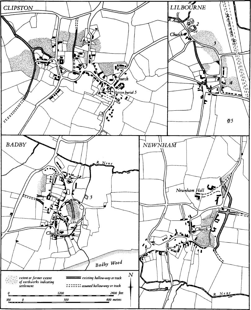
Fig. 11 Badby, Clipston, Lilbourne and Newnham Village plans
In other parishes the pattern is still more obscure. The abandoned village of Glassthorpe in Flore (4) appears to be a good example of a secondary settlement and yet part of its land unit, apparently even in medieval times, extended beyond Flore parish and into the adjacent parish of Brington. Similarly at Watford, the parish in medieval times contained not only the now deserted village of Silsworth (Watford (3)) but also part of the land and half the actual settlement of Murcott; the remainder of Murcott lay in Long Buckby parish (5). The situation at Barby is more difficult to explain. The parish is made up of the lands of Barby village (3) and of the abandoned village of Onley (Barby (1)). The latter may be a secondary settlement of Barby, but a third settlement and its land unit, Barby Nortoft, lay in Kilsby parish to the E. Certainly the situation at Norton, where the lost village of Muscott (Norton (11)) lies within a long narrow projection of the parish to the E. of Watling Street, suggests that Muscott was once a primary settlement with its own land unit and that it was joined to Norton for ecclesiastical purposes only at a relatively late date. The same is probably true of the settlements of Hinton, Woodford and West Farndon in Woodford-cum-Membris (2) and Snorscomb in Everdon (3). Elsewhere the names and shapes of parishes indicate that they were once single units which became divided administratively and ecclesiastically with the growth of secondary settlements. The relationship between Clay Coton (2) and Lilbourne (3) would seem to be an example of this. On the other hand, though the names, shape of the parishes and the admittedly late evidence for intercommoning at Badby and Newnham parishes might suggest the same process, the complex morphology of Newnham (2) and the possibility of a change of name, poses considerable problems of interpretation.
The inherent difficulties in this type of study are nowhere better demonstrated than in the Guilsborough area (Fig. 14). The settlement of Coton and its lands are now in Ravensthorpe (9) but were once in Guilsborough parish. The modern parish of Guilsborough is made up of two land units, each with its own settlement, Guilsborough and Nortoft. To the S. the present parish of Hollowell is also the result of the ecclesiastical unification of Hollowell and Teeton and their respective land units, but as Hollowell was once dependant on Guilsborough, there is some connection between these two also. In effect there seem to be not simply three parishes each made up of two separate settlements and their land, but one large area now covered by Ravensthorpe, Hollowell and Guilsborough parishes, which was perhaps at some time a tenurial or administrative unit made up of at least six distinct settlements and their land. If this supposition is correct then the original unified area must be of considerable antiquity, for the boundary between the medieval hundreds of Guilsborough and Nobottle Grove cuts across it. The possible significance of the borough element in the name Guilsborough and the existence of an important Roman site (5), now destroyed, in the village must also be taken into account.
In many other parishes which contain more than one medieval settlement there is no clear evidence that each of the latter ever had a separate land unit. In some cases, as at Clipston where there is an existing village of Clipston (7) and the deserted village of Nobold (Clipston (6)), lack of documentation makes it impossible to trace the boundaries of units that undoubtedly once existed. Other possible examples of this are at Charwelton (1) and (3), Stanford (4) and (6) and Catesby (2) and (3). Elsewhere it appears that there are genuinely secondary settlements which, because they were always small, never acquired their own land units, for example Cotton End in Long Buckby (7). In places such as Stowe-Nine-Churches, however, where both settlements in the parish are of equal size and status and yet seem to have been associated with a single agricultural unit, there is no clear explanation.
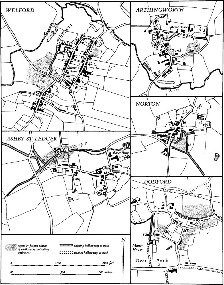
Fig. 12 Arthingworth, Ashby St. Ledgers, Dodford, Norton and Welford Village plans
Another type of medieval settlement in the region is the polyfocal village; this has always had a single land unit but is the result of the merging of two or more discrete centres into one single settlement (Med. Arch., 21 (1977), 189). In the area under review, Byfield and Hellidon are examples without any surviving earthworks and thus are not described in the Inventory. Others which are listed include Naseby (3), where the settlements of Nutcote and Naseby lie side by side, Cottesbrooke (5), where there are still two distinct parts to the village, and Holdenby (3), where there were certainly two centres although later activity has destroyed any evidence as to how close they were. The large deserted village of Kelmarsh (14) may be the result of growth from three centres, and Fawsley (1) is also made up of two parts. The origins of such villages are not understood. Newnham (2), which has at least three and perhaps more focal points, can be explained in a number of ways; the two centres at Sibbertoft (9) may be merely the result of planned extensions of the earlier settlement (Fig. 13). Despite the evidence from field analysis, documentary research and archaeology the origins of the medieval village in this area are still little understood.
Villages, once established, were subject to changes throughout the medieval and post-medieval periods; some grew larger while others declined or were abandoned completely, and many underwent changes of location. The Inventory describes a large number of monuments that have resulted from these processes. Although detailed topographical analysis can indicate the process in certain places, continuous growth or expansion by its very nature has no earthwork remains and is therefore not dealt with in the Inventory. One example is Scaldwell which seems to have resulted from gradual expansion from its central green.
Other circumstances have left visible archaeological features, usually in the form of earthworks. Some villages have been almost completely abandoned but there are many more which have undergone contraction or movement. The reasons for the desertion, shrinkage or movement of the majority of villages in the area are often obscure, partly because changes took place over many centuries as the outcome of complex events, local and national, social and economic, and rarely as the sudden result of one specific cause. The lack of surviving documentation giving information as to the size and population of these places or indicating any other history apart from the manorial descent, also makes it very difficult to isolate either general or specific conditions that caused changes in individual villages or in the overall pattern of settlement in the medieval and later periods. There is an inevitable tendency to pick out the more obvious potential reasons for change or decline but these produce an oversimplified view of the history of medieval settlement. Faxton (Lamport (15)) illustrates the potential weakness of generalizations based on a lack of firm evidence. This village has had large-scale excavation carried out on it, and there is also a wealth of post-medieval documentation. Without this evidence a simple but totally erroneous interpretation could be made of the decline and abandonment of Faxton. Unsatisfactory as the evidence is, it shows a complex picture of continuous change and movement as well as decline, spread over a period of 600 years, but with no obvious explanation for the processes involved.
The date and causes of desertion of the numerous abandoned villages described in the Inventory can be ascertained at only a very few, and even then the facts are probably more complicated than the existing evidence can reveal. It remains generally true that most of the villages that were eventually deserted were those which were always small and weak, but there are some which do not fit this description. Chilcote in Thornby (2) had a recorded population of two and Glassthorpe in Flore (4) of five in Domesday Book; these were obvious candidates for eventual desertion. Canons Ashby (1), however, which had a recorded population of 16 in 1086 and of 82 people over the age of 14 in 1377, and also Sulby (3) which had 89 people over the age of 14 in 1377, seem to be villages which, in spite of considerable prosperity, could still be removed by their monastic lords. On the other hand even the smallest of places might survive. Hothorpe in Marston Trussell (9) had only one person listed under it in Domesday Book. It grew larger so that 57 people over the age of 14 were living there in 1377 and, despite some clearly visible desertion or movement, it lasted until the 19th century when it was finally removed by emparking. Again the recoverable picture is one of considerable fluctuation for no clearly defined reason.
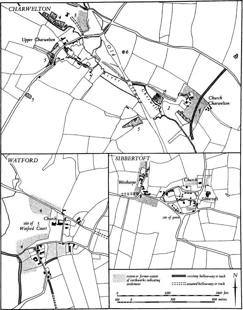
Fig. 13 Church Charwelton, Upper Charwelton, Sibbertoft and Watford Village plans
Many of the villages which still survive may be classified as true shrunken settlements with earthworks which appear to be the result of a reduction of population. Some of these show that part of the contraction took place in post-medieval times. The earthworks at Naseby (3) are especially interesting because sites of houses still standing in 1630 can be identified exactly. Even so, shrinkage at Naseby was taking place before 1630 and a long slow process is indicated, as it is more clearly at Faxton (Lamport (15)). Again, at Haselbech (3) some desertion was apparently the result of late 16th-century enclosure, but some may be earlier, and much was a consequence of 18th-century emparking. Some shrinkage is of very late date, as at Clay Coton (2) and Coton in Ravensthorpe (9), both of which have evidence of 19th-century contraction, although earthworks at both indicate earlier decline. Elsewhere the date of decline is largely unknown, for example at Little Preston in Preston Capes (2), Stanford (4) and Brockhall (1). Earthworks that reveal shrinkage can also provide evidence of earlier expansion. At Little Preston the fact that the abandoned gardens of former houses have cut through a dated deer park boundary implies that this part of the village did not exist when the deer park was created in 1227, nor, presumably, for some time afterwards. At Canons Ashby (1) too the evidence on the ground shows that the N. part of the village, now deserted, was laid out over former arable land. The same feature is detectable at Muscott in Norton (11).
In other villages, where there is no documentary evidence of a reduction in population, the surviving earthworks can indicate movement rather than shrinkage, though the two may sometimes have been combined. At Pitsford (7) the evidence is fragmentary, but at Yelvertoft (4) there is a strong possibility that the original village was situated in a low-lying valley and then moved W., encroaching upon its own fields. The best example of this is at Lilbourne (3) where two stages of apparent movement are detectable. The original village seems to have lain around the now isolated castle and church. It then moved S. into a new position with houses and crofts fitted into existing blocks of ridge-and-furrow. Finally it moved S. again to the hilltop where it still remains. The same process is traceable at Winwick, though the situation is here complicated by shrinkage as well. The evidence on the ground implies a movement of the village upstream along the valley, with the result that the abandoned part, including a manor house site, was ploughed over and incorporated into the village fields. Occasionally such movement appears to be the result of deliberate planning. At Long Buckby (6) the earthworks, now largely destroyed, together with the existing layout of the village indicate that the 11th-century village lay to the N.W. of the present one and that the new village was created around the market place, perhaps in 1280 when it received a market grant. At Sibbertoft the hamlet of Westhorpe, laid out in neat rectangular form, may have been consciously planned as an addition to the earlier village to the E. Likewise at Clipston (7) one part of at least three stages of development seems to have been a planned extension consisting of three parallel streets and a green added to the original village; a later unplanned growth occurred further W. At Welford (13) there is evidence that the whole village is planned. Although the existing settlement could be interpreted as a village along a simple N.–S. road with a back lane to the W., the location of the church and the manor house on that lane, and the earthwork evidence for a third street parallel to the existing ones to the W., make the idea of a completely planned settlement seem probable. The layout of Flore (5) suggests the same process.
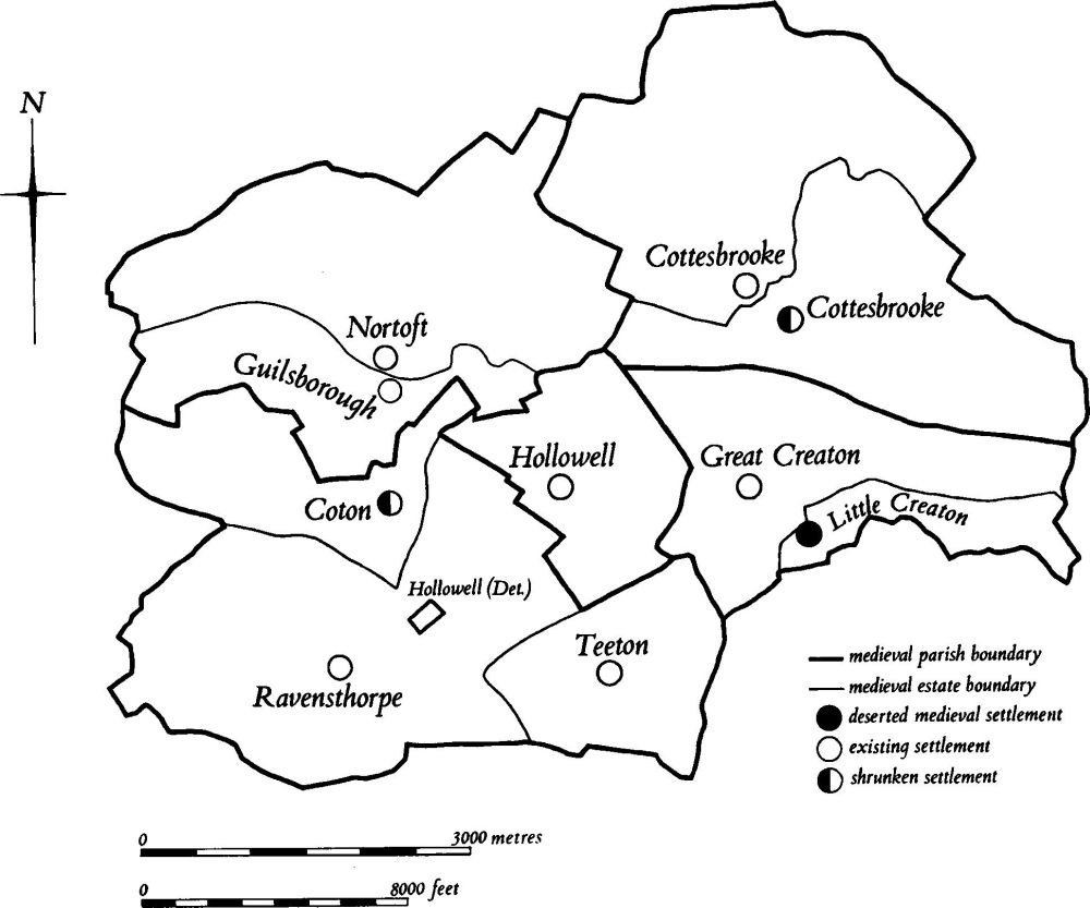
Fig. 14 Cottesbrooke, Creaton, Guilsborough, Hollowell and Ravensthorpe Medieval settlements and estates
In some of the completely deserted villages also there is evidence to suggest that they were laid out on a deliberate plan. The clearest is at Braunstonbury (Braunston (1)); the form of the surviving earthworks suggests a rectangular plan with 'greens' in two of the corners and the moated manor house in a third, and there are slight indications of an internal layout of straight property boundaries. The latter have clearly been distorted by later activity but can just be recognised. The name Braunstonbury, and the location of the village very close to the existing village of Braunston, might be taken as additional evidence for a late, planned origin. The deserted village of Braunston Cleves in the same parish (Braunston (3)) may also be planned. It is oddly arranged on one side of a single street and there is no evidence that any part of it lay on the other side. In addition, the diversion of the existing stream around the ends of the village closes could be the result of co-operative work in the layout of the settlement. Muscott (Norton (11)) also has an unusually regular plan, with a central axial hollow-way and a rectangular street system bounding the village; Glassthorpe (Flore (4)), though much altered by later activity, shows the same features. These may all have been planned settlements, as may the deserted village of Newbold in Catesby (6), now destroyed but clearly visible on air photographs. It is possible that in such apparently planned villages the earthworks reveal a widespread process, the traces of which have elsewhere been destroyed by late medieval and post-medieval occupation and change.
Even where the morphology of existing villages seems to be readily explicable the discovery and recording of associated earthworks can alter the interpretation. Several settlements in this part of Northamptonshire have in the past been described as 'loop' villages and have been regarded as the result of expansion in woodland areas where unused land was readily available. At two of these, Badby (4) and Crick (7), the earthworks in fact indicate a history far more complex. Even superficially simple villages may have considerable earthworks around them which cast doubt on the obvious interpretation of their history. Little Everdon (Everdon (2)) is one such settlement; it now survives only as a single street but in the surrounding fields are hollow-ways lined with former house-sites indicating a more complicated development.
The area also contains villages which have been greatly altered by 18th and 19th-century emparking. At Norton (12) the village was moved sideways in the 19th century as the park of Norton Hall was extended, and at Marston Trussell some of the buildings on one side of the main street were removed to provide a view for the new hall; at Hothorpe the entire village was cleared away in the early 19th century. At Cottesbrooke (5), though the earthworks described in the Inventory elucidate an earlier phase of the village's history, there is good cartographic evidence for two quite separate alterations to the S. part of the village in the 18th and 19th centuries, connected with the changes to Cottesbrooke Park. The enlargement of the park of Watford Court (Watford (5)) led to two distinct stages of change in one part of the village. In the 18th century some of the houses lost their gardens to the new park and a century later the houses themselves were removed as the park was enlarged again. Perhaps the most important example of the alteration of villages due to emparking is at Holdenby (3), not the least because of its early date. The great garden layout, implemented by Sir Christopher Hatton in the late 16th century to go with his new house, involved the replacement of one part of the village by a neatly planned estate village and probably the complete removal of the other part. This is one of the earliest known examples of a village being removed to make a park.
Some of the village earthworks recorded in the Inventory, although of considerable extent, defy interpretation and can only be said to indicate changes over a long period. Those at Lamport (8) and at Nobottle (Brington (3)) fall into this category. More interesting were the earthworks at Dodford (1), now destroyed, which must have been the result of a sequence of changes over several centuries. The continuing destruction of such sites as existing villages are enlarged or filled in by modern housing development is a serious problem, and their removal without excavation means that much of the archaeology of these places may soon be impossible to recover.
A most important aspect of the work on earthwork remains of medieval villages in this area relates to the period after abandonment. It has been recognised that many deserted villages (e.g. Nobold in Clipston (6), Glassthorpe in Flore (4), Onley in Barby (1), Sulby (3), Little Oxendon in Great Oxendon (9), Upper Catesby in Catesby (2) and Hothorpe and Thorpe Lubenham in Marston Trussell (9) and (8)), have later been completely or largely ploughed in ridge-and-furrow. Some of this ploughing, as over parts of Onley and Upper Catesby, is almost certainly of late date, perhaps late 18th or 19th century, but in most cases it is likely to be earlier. The details are discussed below under cultivation remains.
Medieval Earthworks
Settlement Remains
Thirty-three deserted villages are recorded in the Inventory: Althorp (1), Barby Nortoft (Kilsby (2)), Boughton Green (Boughton (7)), Braunstonbury and Braunston Cleves (Braunston (1) and (3)), Canons Ashby (1), Calme in Clipston (p. 49), Church Charwelton (Charwelton (1)), Chilcote (Thornby (2)), Downtown (Stanford (6)), Elkington (6), Fawsley (1), Faxton (Lamport (15)), Glassthorpe (Flore (4)), Holdenby (3), Hothorpe (Marston Trussell (9)), Kelmarsh (14), Little Creaton (Creaton (10)), Little Oxendon (Great Oxendon (9)), Lower and Upper Catesby (Catesby (2) and (3)), Muscott (Norton (11)), Newbold (Catesby (6)), Nobold (Clipston (6)), Onley (Barby (1)), Shenley (Yelvertoft (3)), Silsworth (Watford (3)), Snorscomb (Everdon (3)), Stanford (4), Sulby (3), Thorpe Lubenham (Marston Trussell (8)), Thrupp (Norton (10)), and an un-named settlement in Watford (2).
Visible traces of some deserted villages were removed centuries ago. Calme in Clipston is hardly recorded after 1086 and its site has not been located. Boughton Green, if indeed it was a separate settlement, was largely destroyed in antiquity. The remains of one of the parts of the village at Fawsley were levelled in the 18th century during emparking, and Thrupp was ploughed up apparently before the 19th century. The two separate parts of Holdenby were destroyed as early as the late 16th century; a new village was laid out on top of one of them and a garden on the other.
The sites of other deserted villages were also severely damaged or altered many years ago. Part of Lower Catesby was destroyed to make medieval monastic ponds (Catesby (4)), a section of Braunston Cleves was damaged by drainage works in the 19th century and a large piece of Kelmarsh seems to have been ploughed out during the 18th-century emparking. Another process, already noted and historically of more interest, has altered a number of sites, namely the late or post-medieval ploughing which has made the interpretation of surviving earthworks very difficult.
It is in recent years, however, that the greatest destruction has occurred. Lower Catesby has been almost completely levelled by modern ploughing, as have Silsworth, Elkington and Upper Catesby. The sites of Newbold in Catesby, Downtown and Faxton have all been totally destroyed since 1944 and small areas of Muscott and Church Charwelton have suffered a similar fate. Despite this destruction some of the most interesting deserted villages of Midland England still survive intact in the area under review, and a number of important features are recognisable. Most deserted villages, at least towards the end of their lives, lay either along important through roads or around complicated street systems, all now reduced to hollow-ways. At Braunston Cleves the single main street is still well preserved; a similar main hollow-way at Church Charwelton is blocked by a later fishpond at its S.W. end. Main hollow-ways blocked by later ridge-and-furrow exist at Onley and Sulby and there are also good examples of hollowed main streets at Little Oxendon and Nobold in Clipston. At Upper Catesby part of the through road still survives but the late 19th-century estate hamlet has been laid across one section. At Braunstonbury, Muscott and Glassthorpe more complex arrangements of streets and lanes are visible, perhaps as the result of conscious planning (see p. xliv). In some villages only the back lane survives as a hollow-way, as at Canons Ashby and Hothorpe. Many existing roads still follow the main medieval street, for example at Canons Ashby, Little Creaton and Kelmarsh. At a few places the unusual origin of medieval streets is still apparent. At Onley one of the streets followed the original course of a stream which even in medieval times was also the overflow channel from the manorial fishponds, and at Glassthorpe at least one of the abandoned hollow-ways seems once to have been a stream. Likewise the hollow-way at Snorscomb could not have been used as a through route unless the deeply cut stream which it meets at its N. end was also part of the road system of the area.
Well-preserved house-sites are comparatively rare. In villages with later ridge-and-furrow ploughing, only slight depressions or low rounded platforms indicate the sites of former buildings. Even where such destruction has not occurred the assumed wooden structures have left no clear surface trace. Earthworks of this form survive at Kelmarsh, Little Oxendon, Nobold in Clipston, Muscott and Braunstonbury. The best house-sites are seen at Snorscomb where the footings of what appear to be stone-built rectangular structures survive up to a height of 0.5 m.
As noted in a previous volume (RCHM Northants., II (1979), liv), house-sites in villages that were removed for emparking at a late date hardly ever survive, presumably because they were deliberately destroyed rather than being left to gradual decay as in villages abandoned earlier. The former is well exhibited at Hothorpe.
All the deserted villages have embanked, ditched or scarped closes or paddocks around them. Closes lying along streets and with remains of buildings within them are probably the original gardens or crofts, but the exact function of these is not always clear. Others were probably small enclosed fields, now reduced to earthworks because of changing land use, and should not be regarded as evidence of large settlements now depopulated.
Sites comprising earthworks of moved or shrunken villages are more common than deserted villages in this area. Over 40 such places are recorded in the Inventory but these are only the major ones and those of special interest. Every village has at least one or two places where houses formerly stood, many of which may have been abandoned in relatively recent times. Some are extremely well preserved and often cover large areas. The one at Clipston (7) consists of a number of abandoned streets or lanes as well as good house-sites, closes and paddocks. At Lilbourne (3) the earlier furlongs into which the houses and gardens were fitted still survive. Other examples are at Little Everdon (Everdon (2)), Naseby (3) and Watford (4).
Embanked paddocks or closes lying behind surviving buildings are another type of settlement feature associated with existing villages. They do not imply shrinkage, only a change in land use or ownership. Such remains have been noted at Drayton (Daventry (31)), Cottesbrooke (5) and Barby (3).
Major areas of earthworks such as those at Dodford (1) and Long Buckby (6) have been totally destroyed within recent years, and many others, as at Cold Ashby (3), Draughton (10) and Marston Trussell (6), have been severely damaged. In other places, largely as a result of special circumstances, the survival of the earthworks is notable (e.g. Little Everdon (Everdon (2)).
The present process of expansion and infill in the majority of rural villages means inevitably that more of these monuments will be destroyed in the near future. In many places there are areas which need to be excavated before such destruction occurs. At Crick for example it would be of considerable interest to know if the earthworks represent an early part of the settlement or a later addition to it, and at Newnham (2) and Watford (4) the considerable problems surrounding the origins and development of the villages might be at least partly explained by excavation of the remaining earthworks. The assumed two-stage movement at Lilbourne (3) could be proved or refuted by relatively small-scale archaeological work.
Moated Sites
Fewer than ten moated sites are listed in the Inventory. Of these the earthworks at Thornby (3) may not be a moat and those at Thrupp (Norton (10)) and Faxton (Lamport (16)) have been partly destroyed, so their original form is unknown. The rest are all typical medieval moated sites and little new general information has been gained from their examination. All are small and appear to have consisted of a single moated enclosure except at Marston Trussell (7) and Barby (2) where outer enclosures can be traced. None of the sites is truly defensive, the ditches being neither wide nor deep. Indeed, at Arthingworth (4) and Winwick (1) the moats were dominated by adjacent rising ground. Except for the one at Badby (3), which was fed by a small stream, all seem to have been filled by springs or intermittent seepage; all appear to have been sites of medieval manor-houses. The Badby site was fully excavated before its total destruction and an interesting sequence emerged of buildings associated with a monastic grange of Evesham Abbey from the early 13th to the 16th century.
The moated site at Braunstonbury (Braunston (1)) may have been built as part of the original village for its lies neatly in the N.W. corner of the rectangular village earthworks. The moat at Winwick (1) was, with the adjacent village remains, ploughed over with later ridge-and-furrow.
Manor House Sites
Apart from the moated sites already noted and some of the smaller castles listed below there are 12 other places which appear to have been the sites of unmoated medieval manor houses. Some, such as that at Hanging Houghton (Lamport (13)), were not abandoned until well into the post-medieval period and have garden remains associated with them (see p. liv). Others may have been deserted earlier. Most are unimpressive earthworks of little intelligible plan, e.g. Catesby (5) and Hellidon (1), and others retain only the remains of former paddocks and closes, the house-sites themselves having been destroyed or built over, e.g. Welford (14). Of some interest is the manor house site at Holdenby (3) which was turned into a formal garden in the 1580s. The best preserved, with its external boundary bank and building platforms still intact, is in the deserted village of Little Oxendon (Great Oxendon (9)); it lies along the edge of the former main street.
Castles
A number of motte and bailey castles are recorded in the Inventory. The finest is perhaps Lilbourne Castle (2) where two stages of development can be recognised; the original motte with its small bailey appears to have had a massive second bailey added to it on the uphill side. At Lilbourne there is a second motte (1), in an isolated position on a hill to the W. of the village; it is rare to find two mottes so close together. The motte at Farthingstone (4) is unusual in having three baileys, but at least one of these may be a much earlier, perhaps prehistoric, fortification. Another finely preserved motte and bailey at Sibbertoft (8), like those at Farthingstone and on the ridge-top at Lilbourne, lies remote from any known medieval settlement.
The purpose of these isolated mottes cannot be ascertained. All are in strong defensive positions, but none has great strategic importance. They contrast strongly with other mottes at Lilbourne (2) and at Preston Capes (1) which seem to control roads or river crossings as well as protecting adjacent settlements. Two other earthworks are possibly mottes, though this is uncertain. The mound at Little Preston (Preston Capes (3)) is damaged but seems to have been surrounded by a deep defensive ditch. It is in a strong tactical position but may be only a manor-house site. The so-called castle at Barby (2) is also well sited and strongly defended but can hardly be described as a true motte.
The ring and bailey at Long Buckby (8) is of interest for a number of reasons. Its position indicates that it protected not the present village but an earlier one on a different site. It is unusual in that it has a ring-work instead of the normal motte, and there is a possibility that it once had two baileys. In addition a small excavation has suggested late Saxon occupation on the site pre-dating the construction of the castle.
Of all the mottes in this area only the one at Preston Capes (1) can be dated; a document makes it clear that a castle was in existence by 1090.
Monastic Sites
Six monuments directly associated with religious houses are recorded in the Inventory. Two of them, the now destroyed moated site at Badby (3) and the finely preserved one at Cottesbrooke (4), are merely outlying grange farms of major houses. The only earthwork remains of Daventry Priory are the fishponds (Daventry (30)). Some fragmentary earthworks survive of the priory at Canons Ashby (2), but the best-preserved earthworks on the site appear to be the remains of a post-Dissolution garden and are probably not of monastic date as hitherto supposed. There is great potential for future excavation, however, including the greater part of the priory church. The small priory at Catesby (4) has left few surface remains, again because a large house and its gardens were later constructed on the site. These gardens, now reduced to earthworks, include a feature sometimes described as a moat and other remains which have been attributed to the priory but in fact only a group of ponds, some of which were altered in post-medieval times, are definitely associated with the priory. The most important monastic site is that of Sulby Abbey (Sulby (2)). The history of this house is well documented and the earthworks of the church and conventual buildings as well as fishponds, rabbit warrens, a mill site, paddocks and tracks are almost completely preserved in permanent pasture.
Deer Parks
A small number of deer parks have been identified in the area. The best example is at Badby (6); this is well documented, and its boundaries are almost completely preserved. The deer park at Little Preston (Preston Capes (4)) is less complete but is of special interest because the abandoned remains of the hamlet of Little Preston overlie one section of the park pale. The deer park at Holdenby (5) was a very late one, created in the 1580s by Sir Christopher Hatton as part of the large-scale reorganization of the parish at that time. The Badby park has no ridge-and-furrow in it. At Preston Capes there is no indication as to whether surviving furlongs pre-date or post-date the park but at Holdenby the park was laid out across the former common fields of the parish and there is extensive ridge-and-furrow within it.
Fishponds
In north-west Northamptonshire there are many fishponds, dating mainly from the medieval period. Not all have been described in the Inventory in detail and several which may be medieval in origin but have been radically altered in recent times have been omitted. The ponds which have been recorded can be assigned to four of the types described in detail in an earlier volume, A, B, C, F; no examples of types D, E, or G have been recognised (RCHM Northants., II (1979), p. lvii).
Type A. These ponds are formed by the construction of a simple earthen dam across a steep-sided valley. Examples are to be seen at Canons Ashby (4), though later alterations have taken place, at Catesby (4) where the ponds appear to be monastic in origin, at Creaton (10), Elkington (6) and Little Oxendon (Great Oxendon (9)), all within deserted villages, and at Sulby Abbey (Sulby (2)) where the main fishpond is of this type. A late example at Holdenby (3) was constructed in the 1580s.
Type B. Ponds in this category are formed by the construction of a dam as in Type A but in addition large quantities of material are removed to make them deep and flat-bottomed. They are characterised by steep artificial scarps along their sides where the valley slopes have been steepened or cut away. This type is well demonstrated at the deserted village of Braunstonbury (Braunston (2)), at Daventry (30) where the ponds belonged to Daventry Priory, at Lamport (9) and at Welford (15).
Type C. These ponds are set on valley sides and have dams on one of the long sides formed by spoil cut out of the hillside. This type was filled either by being built on a spring-line as at Dodford (2) or by means of an inlet channel carrying water to the pond from higher up the valley (Maidwell (15)).
Type F. These are small rectangular ponds, usually in groups. They were commonly called stews and were probably used for intensive fish-breeding. The best of these are at Sulby Abbey (Sulby (2)).
One of the most interesting aspects of many medieval fishponds is the great skill in large-scale hydraulic engineering which they reveal. Even some of the smaller fishponds show this, as at Maidwell (15) where water from a very large pond passed along a carefully graded high-level leat into another smaller pond set on the valley side. Other examples may be seen at Welford (15) where an inlet channel brought water from an adjacent stream to a large fishpond, and surplus water was carried round the pond in another channel and returned to the stream. The most complicated systems are those at Charwelton (2) and Sulby (2). At Charwelton at least two stages of development are visible, one of which appears to be later than the abandonment of Church Charwelton village (Charwelton (1)). At one stage water taken from the River Cherwell passed through a series of ponds and returned to the river. The later stage involved the construction of a leat some 500 m. long to carry water to another group of ponds at a higher level than the earlier ones. At Sulby (2) the monastic ponds represent a major feat of engineering. The River Avon appears to have been diverted along the valley side, passing at one point through a deep cutting, to feed a series of fish stews and probably also a watermill. Other ponds were set above the diverted river on a spring-line and a large dammed pond in the old river valley was also connected to the system.
The existence of islands in fishponds noted in the second Inventory (RCHM Northants., II (1979), p. lix), has again been recognised. One of the ponds at Preston Capes (5) has a narrow elongated island within it, which certainly remained well above water level when the pond was full; the rectangular island in the pond at Welford (15) is similar. On the other hand the roughly circular islands at Maidwell (14) are only a few centimetres high and must have always been well below the water.
Watermills
In north-west Northamptonshire watermills have always been common; more than a hundred are documented for the region. Many survive as standing structures and are not included in this Inventory. Only those watermills which appear to have been abandoned at an early date or where the remaining earthworks are of exceptional interest have been described. These include the remains at Murcott (Long Buckby (5)), Little Oxendon (Great Oxendon (9)), Sulby Abbey (Sulby (2)) and Yelvertoft (4).
Windmills
As with watermills there are numerous documented windmills in the area and many are still marked on 19th-century Ordnance Survey, Tithe and Enclosure Maps. The inclusion of the mounds, which often remain after demolition, has been selective in the Inventory. Almost all are simple mounds with or without surrounding ditches, and the finest are those of an early date. There are good examples at Canons Ashby (6) Preston Capes (8), Thornby (4), Great Oxendon (8) and Charwelton (6).
Cultivation Remains
Ridge-and-furrow in Open Fields
In spite of modern arable farming, large areas of ridge-and-furrow remain intact, and air photographs often reveal the pattern of furlongs where it can no longer be seen on the ground. There is no doubt that in the medieval period some form of ridge-and-furrow cultivation existed throughout the area, in every land-unit associated with a major settlement. In the parish of Flore, for example, both Flore itself and the now deserted village of Glassthorpe (4) each had its own field system.
As in the two previous Inventories, examination of ridge-and-furrow on the ground or on air photographs has shown that at various times cultivation was more widespread than the surviving maps indicate. In many places the whole of the land-unit of each village appears to have been cultivated in ridge-and-furrow at some date except for small areas of meadow along streams (e.g. Naseby (5) and Welton (5)). At least one medieval deer park (Preston Capes (4)) has ridge-and-furrow within its boundaries, although the date of cultivation is unknown. Elsewhere areas which immediately before enclosure in the 18th or 19th century were permanent pasture or the waste limits of a group of parishes, have extensive areas of ridge-and-furrow. At Long Buckby (9), land in the E. of the parish known as North Heath Common and Thorney Heath Common in 1765 is almost completely covered with ridge-and-furrow; at Newnham (5) Langhill Common and Burnt Walls Common, so named in 1765, have ridge-and-furrow over them. In other places, however, there were large areas which were either always waste or cultivated by methods other than ridge-and-furrow. This is particularly true of parishes in the S.W. of the area where much land is on extremely steep slopes which were impossible to cultivate, as in Staverton (3) and Barby (4). Near Little Preston (Preston Capes (2)) the hillside, though not abnormally steep, has never been cultivated, apparently because of the unstable nature of the underlying clay which has collapsed in a series of landslips. Elsewhere there seem to be areas which have never been ploughed, simply because other land was available. The N. side of Fawsley parish illustrates this well, for there is a large area on a gentle slope with no trace of cultivation of any date. In a few places, for example at Barby (4), there are small pieces of land which seem to have been brought into cultivation as hedged fields; no ridge-and-furrow exists within them.
Very few maps survive to show the layout of the former common fields and only one, of Brixworth (1688), depicts the individual strips. Nevertheless there is no reason to doubt the accepted view that the surviving ridge-and-furrow usually represents individual strips, lands or selions made up of groups of ridges but with no physical demarcation.
Enclosure of the common fields was carried out over a long period. Some small-scale enclosure undoubtedly took place in medieval times, perhaps as early as the 14th or 15th century in some places where the date of enclosure is unrecorded. These villages include Onley (Barby (4)), Braunstonbury (Braunston (7)), Cold Ashby (4), Little Creaton (Creaton (11)), Kelmarsh (18), Little Preston (Preston Capes (10)), Coton (Ravensthorpe (10)), Draughton (14) and Hanging Houghton (Lamport (19)). Most of these settlements are either completely deserted or very small. Evidence of early enclosure on a limited scale is also recorded at Chapel Brampton (14) where it took place before 1584. In addition 15th-century enclosure probably occurred at Sulby (5), Althorp (3), Catesby (8), Newbold (Catesby (8)), Glassthorpe (Flore (6)) and Muscott (Norton (16)). The enclosure of Thrupp (Norton (16)) is firmly dated to 1489. All these villages are also now deserted.
Enclosure is known to have taken place in the 16th century at the following places: Canons Ashby (7), 1539–47; Haselbech (4), 1599; Holdenby (7), 1584–7; Teeton (Hollowell (7)), 1590. Other parishes probably enclosed in the 16th century are Fawsley (8), Elkington (7), Snorscomb (Everdon (6)) and Stanford (7), though all of these could be earlier. Once more, deserted or shrunken villages predominate in this list.
During the 17th century there was a gradual but steady process of enclosure. Part of East Haddon (3) was enclosed between 1598 and 1607, Cottesbrook (7) in the early 17th century, Brockhall (2) in about 1619, Dodford (3) in 1623, Sibbertoft (3) in 1650, Preston Capes (10) in 1659, Clay Coton (3) in 1663, part of Watford (6) in 1664, Lilbourne (6) in 1680, Stowe-Nine-Churches (12) in the late 17th century and Maidwell (16) in the late 17th or early 18th century. All these enclosures were carried out by agreement between major landowners and though some of the villages were large, e.g. Lilbourne and Preston Capes, others, e.g. Clay Coton and Watford, were much reduced in size by then. The first half of the 18th century saw little enclosure and it was not until the 1740s that the movement towards parliamentary enclosure began. In that decade both Brington (5) and Faxton (Lamport (19)) were enclosed. Thereafter parliamentary enclosure became common.
In the 1750s seven parishes were enclosed, Drayton (Daventry (34)), Farthingstone (6), Norton (16), Welton (5), Pitsford (8) and Hinton and Woodford (Woodford-cum-Membris (3)), followed by eleven parishes in the 1760s, West Farndon (Woodford-cum-Membris (3)), Everdon (6), Ashby St. Ledgers (7), Guilsborough (8), Spratton (15), West Haddon (3), Newnham (5), Harlestone (13), Long Buckby (9), Arthingworth (6) and Great Oxendon (10).
The 1780s were the years of the greatest number of formal Enclosure Acts; eighteen villages lost their common fields, Watford (6), Murcott (Watford (6)), East Haddon (3), Hellidon (2), Staverton (3), Scaldwell (3), Yelvertoft (5), Braunston (7), Clipston (8), Crick (10), Welford (17), Weedon Bec (3), Kilsby (5), Barby (4), Byfield (5), Flore (6), Whilton (3) and Badby (8). The process then slowed down and between 1780 and 1802 only six parishes or parts of parishes were enclosed, Brixworth (42), East Farndon (7), Creaton (11), Lamport (19), Ravensthorpe (10) and Daventry (34). The enclosure of Marston Trussell (10) in 1813 and Naseby (5) in 1820 saw the end of the process in the area.
Analysis of the ridge-and-furrow associated with the common fields in this area has not led to any new conclusions (RCHM Northants., II (1979), p. lxi). The relationship between the natural configuration of the ground and the arrangement both of the shape of the furlongs and of the direction of the ridges sometimes causes striking patterns, but no new information on the origins and evolution of the fields has come to light. Such new evidence as has been recorded tends to show how little understood are the agricultural techniques used to produce ridge-and-furrow. Many minor details still defy explanation; for example in the N.W. of the area, especially in Kilsby (5), there are extensive areas of ridge-and-furrow of normal form but with a low narrow ridge set in each furrow between the main ridges (Fig. 88). One possible explanation is that it represents an attempt to increase the amount of grassland available. In Brixworth and in Wollaston in the S.E. of the county 17th-century documentary evidence shows that farmers were advised to leave grass strips between ridges so that tethered animals could graze on them (D. N. Hall, Wollaston (1977), 150), but whether this explains the large areas of ridge-and-furrow of this unusual form is not certain. Another detail difficult to interpret is the occurrence of high, rectangular mounds at the ends of ridges. Small rounded mounds on the ends of ridges are common throughout the English Midlands and have been explained as the spoil from the cleaning out of adjacent furrows for drainage or accumulated material removed from plough shares, the deposited spoil being reploughed to reduce the mounds. However the rectangular mounds at Brington (5) are so large and neat that it is difficult to see how they could have been either formed or ploughed over.
The detailed examination of ridge-and-furrow has continued to reveal not only the complexity of the agricultural techniques used but also their flexibility. A minor example at Watford (6) (Plate 21) shows this well. A later track cuts across a block of ridge-and-furrow, and mounds have subsequently been formed at the ends of the ridges on either side of the track. Sets of double and even triple mounds on the ends of furlongs in the same area are puzzling and not understood. Double headlands perhaps indicating a shortening of furlongs occur at Crick (10), where there is also evidence of the overploughing of apparently early quarry pits with ridge-and-furrow. Similar overploughed quarry pits have been noted at Great Oxendon (10). Also unusual are the circular areas of flattened ridge-and-furrow which occur at Brixworth (42). These can be identified as the places where ricks were shown on a 17th-century map of the parish. The parish was not enclosed until 1780 and the rick-stands were perhaps a permanent feature of the field system.
Ridge-and-furrow in 'Old Enclosures'
As in previous Inventories, ridge-and-furrow has been noted in many fields described on 19th-century or earlier maps as 'old enclosures'. Perhaps the most interesting aspect of ridge-and-furrow of this type is its occurrence over the remains of abandoned settlements. At the deserted villages of Nobold (Clipston (6)), Glassthorpe (Flore (4)), Onley (Barby (1)), Sulby (3), Little Oxendon (Great Oxendon (9)), Upper Catesby (Catesby (2)), Hothorpe and Thorpe Lubenham (Marston Trussell (9) and (8)) and at some shrunken or moved villages such as Winwick (1) the whole area or large parts of the earthworks have been overploughed with ridge-and-furrow. Unfortunately it is difficult to assign this ploughing to a particular date, but it appears to be of two different types, probably of different periods. Fine narrow-rig ploughing 2 m.–3 m. wide of a type usually dated to the late 18th or early 19th century lies over part of the deserted village of Onley (Barby (1)). This is very different from the ridges 5 m.–7 m. wide over most of the settlement sites. An example of the difficulty of dating this ridge-and-furrow may be seen at Glassthorpe (Flore (4)). The site is largely overploughed in broad ridge-and-furrow, but is now under pasture and has been so, according to local knowledge, for at least a century. It was certainly pasture in the mid 19th century according to the Tithe Map and also in 1758 from other cartographic evidence. In the early 18th century Bridges implied that it was a sheep-walk and sheep were grazed there in considerable numbers in the mid 16th century. The date of the final desertion of the village is not known with certainty but it appears to have been after the late 14th century. Thus the most likely periods for the ploughing to have taken place at Glassthorpe were either the 15th or the 17th century. However it is unlikely on general economic grounds to have been in the 15th century when the abandonment of arable land was common, and a 17th-century date is therefore more probable. Support for this is forthcoming from Sulby where the abandonment of the village for sheep certainly occurred between 1377 and 1428 and where sheep remained important until after the mid 16th century.
The 17th century might well be the period when this ploughing was done and a possible explanation is that pasture was broken up either for a rotation system of long leys or for the production of specialized crops such as woad or flax. Apart from these possibilities, this interesting if minor aspect of agricultural history is undated and unexplained.
Narrow Ridge-and-furrow
This part of Northamptonshire has cultivation remains of a type not seen in the areas previously described. Narrow ridge-and-furrow usually known as narrow-rig has been recognised. It is thought to be relatively recent, probably of late 18th or early 19th-century date. At Onley (Barby (1)) narrow-rig lies over part of the deserted village and from its appearance would seem to be comparatively recent. At Lamport (19) it clearly overlies medieval ploughing for the earlier headlands are still visible on the ground. Narrow ridge-and-furrow also exists at Crick (10), and at Sulby (2) where the whole of the former monastic fishpond is covered by such cultivation remains.
Post-medieval Earthworks
Fortifications
The Battle of Naseby of 1645 has prompted traditions concerning 17th-century fortifications in the N. part of the area under review. However nothing has been discovered that can be assigned to the battle or to events leading up to it, apart from the grave recorded at Sulby (4). A site at Kelmarsh (16) was excavated and published as a Civil War sconce but is much more likely to have been a medieval fishpond. The only certain post-medieval fortification is the unusual redoubt at Weedon Bec (2) which was probably built in the early 19th century, perhaps as a training exercise by troops stationed at Weedon Barracks.
Garden Remains
The remains of gardens, often elaborate, associated with great houses have continued to be discovered. Those listed in the Inventory cover a variety of garden designs from the mid 16th to the 18th century. The earliest is that at Canons Ashby (2) which though usually said to be of monastic origin appears to be immediately post-Dissolution in date. The site has been largely destroyed but enough remains for the general outline to be reconstructed. The next in date are probably the gardens at Holdenby (4), among the finest in the county, laid out by Sir Christopher Hatton in the 1580s. The great terraces and ponds and even some of the flower-beds are well preserved. An extension to the original garden, perhaps of the early 17th century, includes an elaborate series of sloping terraces, forming a zig-zag path. The gardens at Catesby (4), which consist of impressive terraces and ponds, are also likely to be early 17th century, and at Arthingworth (4), Fawsley (1), Lamport (12) and Hanging Houghton (Lamport (13)) are other definite or assumed 17th-century remains. The garden at Cottesbrooke (6) was of very different character and apparently of the early 18th century. The original layout at Watford (5) is also of the 18th century, though considerable later alterations have taken place there. Other earthworks connected with gardens or emparking have been noted at Althorp (2), Canons Ashby (5), Draughton (11) and Haselbech (3).
Undated Earthworks
Without excavation the purpose and date of a number of monuments in the Inventory must remain speculative. The most important of these is the earthwork known as Burnt Walls (Daventry (35)). This site has an obvious defensive function and may be pre-medieval, but its unusual form and position prevent any precise date being given to it. The enclosures on Borough Hill (Daventry (3) and Norton (17)) are also of unknown purpose, and their almost total destruction makes any future understanding of them unlikely.
Miscellaneous Earthworks
As in previous volumes earthworks resulting from medieval and later woodland management and 19th-century ironstone tramways have been omitted from the Inventory for the reasons stated (RCHM Northants., II (1979), p. lxv). Such remains would well repay detailed study for they illustrate two important aspects of Northamptonshire's history. Earthworks associated with the canals and early railways of the county have also been omitted.
Total Landscapes
The Inventory is, by definition, a detailed list of individual monuments. Many are of considerable historical or archaeological interest, even when viewed in isolation, but all are part of the history of a slowly evolving landscape and should always be regarded as such. It is often difficult to appreciate relationships between individual sites, whether contemporary or of different date. In the area covered by the present Inventory, however, two parishes stand out as excellent examples of the total historic landscape. The first is Holdenby, which is remarkable in that its medieval pattern, with two villages, was entirely reorganized in the space of a decade by Sir Christopher Hatton in the 1580s. The villages were removed and replaced by a single village, the fields enclosed, a deer park constructed and an elaborate garden laid out around the new house. Though many of the surviving remains have been damaged the parish is a clear example of a complete and dated change of landscape. At Fawsley, on the other hand, most of the parish has been preserved by the 18th-century park so that earlier landscapes including two medieval villages and their fields, areas of pasture and waste as well as part of a deer park and other medieval and post-medieval features have survived. These historic landscapes are particularly worthy of conservation.