Survey of London: Volumes 31 and 32, St James Westminster, Part 2. Originally published by London County Council, London, 1963.
This free content was digitised by double rekeying. All rights reserved.
'The Bailiwick of St. James', in Survey of London: Volumes 31 and 32, St James Westminster, Part 2, ed. F H W Sheppard (London, 1963), British History Online https://www.british-history.ac.uk/survey-london/vols31-2/pt2/pp24-31 [accessed 3 May 2025].
'The Bailiwick of St. James', in Survey of London: Volumes 31 and 32, St James Westminster, Part 2. Edited by F H W Sheppard (London, 1963), British History Online, accessed May 3, 2025, https://www.british-history.ac.uk/survey-london/vols31-2/pt2/pp24-31.
"The Bailiwick of St. James". Survey of London: Volumes 31 and 32, St James Westminster, Part 2. Ed. F H W Sheppard (London, 1963), British History Online. Web. 3 May 2025. https://www.british-history.ac.uk/survey-london/vols31-2/pt2/pp24-31.
In this section
CHAPTER I
The Bailiwick of St. James
Volumes XXXI and XXXII of the Survey of London describe that part of the parish of St. James, Westminster, which lies north of Piccadilly. (fn. 1) With the exception of Colman Hedge Close, on the west side of Wardour Street, and possibly of a small strip on the east side of Great Windmill Street, all of this area was part of the Bailiwick or Manor of St. James, which was formed by Henry VIII in 1531–6 out of lands in the parishes of St. Martin in the Fields (which then included all of the area later to become the new parishes of St. James and of St. Anne), St. Margaret, St. Giles in the Fields, Fulham and Chelsea. These lands were surrendered to the King by the Provost and College of Eton (1531), the Abbot and Convent of St. Peter's, Westminster (1531, 1536), the Abbot and Convent of Abingdon, the Mercers' Company, the Master of the Hospital of Burton Saint Lazar (1536), and a number of private individuals. A short account of the history of the bailiwick as a whole is contained in Survey of London, vol. XXIX, pages 21–3.
Colman Hedge Close was never acquired by the Crown and therefore did not form part of the bailiwick. Its history is described on page 219.
Henry VIII's purpose in acquiring these lands may have been, at least in part, to gain control of the ground from which the water supply for Whitehall Palace was obtained. (fn. 2) But his policy of concentrating the ownership of this land in the hands of the Crown was quickly reversed, for in January 1559/60 Elizabeth granted in fee some sixty acres in the parish of St. Martin in the Fields (together with other lands elsewhere) to William Dodington (Doddington) of London, gentleman (fn. 6) (fig. 1). All of this ground had formerly belonged to the Mercers' Company (fn. 7) and much of it lay within the area covered by this volume. No more Crown land in this area was granted away in fee until 1664. The grant to Dodington therefore provides the natural starting point for a survey of the estate history of the area under review.
Dodington's Freehold Lands
During the reign of Edward VI and the early years of that of Queen Elizabeth, William Dodington obtained several grants of former Church lands in various parts of the country. (fn. 8) On 24 July 1560 he sold his lands in St. Martin's, together with other property elsewhere, to John Tamworth, esquire, 'one of the gromes of the quenes maiesties most honorable privye chambre'; on 2 June 1561 the latter sold the sixty acres in St. Martin's to Thomas Wilson of St. Botolph without Aldgate, brewer. (fn. 7) These lands were intermingled with ground still in the possession of the Crown, and which had formerly belonged to the Abbot and Convent of Abingdon and the Hospital of Burton Saint Lazar. To add to the confusion, both Wilson and the tenants under the Crown were gradually enclosing much of their ground which had hitherto been parish Lammas land, (fn. 9) where the parishioners had grazing rights from Lammas Day (1 August) until the spring.
In c. 1580 James Bristow, a man of some substance in the parish of St. Giles and the tenant under the Crown of most of the Abingdon and Burton Saint Lazar lands, (fn. 10) claimed part of Wilson's land, (fn. 11) and a long series of lawsuits followed. During this litigation a plan (Plate 1) of the fields in question was made in 1585, and on fig. 2 this is related to the modern street layout. The documents in the various lawsuits, including the plan itself, formed the foundation of C. L. Kingsford's The Early History of Piccadilly, Leicester Square, Soho and Their Neighbourhood, which was published for the London Topographical Society in 1925. The litigation between Bristow and Wilson is described in detail by Kingsford, and is therefore only summarized here. (fn. 3)
The dispute concerned some four acres of ground in the vicinity of Poland Street called Little Gelding's Close. The point at issue was whether the whole close, which in the 1560's had been divided into two, (fn. 12) had formerly been part of the Abingdon lands, and should therefore have devolved upon Bristow as the tenant under the Crown, or whether it had formerly belonged to the Mercers' Company and therefore formed part of the lands granted by the Crown in fee to Dodington in 1559/60, and subsequently acquired by Wilson. Since his entry on the Abingdon lands in 1574 Bristow had apparently enjoyed the profits of the smaller, western part of Little Gelding's Close (subsequently known as Pawlett's Garden), (fn. 13) and in c. 1580 he exhibited a bill of complaint in the Court of Exchequer against Wilson, in which he claimed that the larger, eastern part of the close had also been part of the Abingdon lands. In January 1584/5 a commission was appointed to set out the boundaries of the lands held by Wilson under the grant to Dodington, and of the lands formerly held by the Abbot and Convent of Abingdon, and 'to make a trewe plotte' (i.e. map) of Little Gelding's Close. (fn. 14)
The commissioners took depositions from a number of ancient inhabitants and made a plan (fn. 15) (Plate 1) in which the lands formerly belonging to the Abbot and Convent of Abingdon were marked with a letter A, those of the Hospital of Burton Saint Lazar with a B and those of Mr. Wilson with a W. (fn. 16) So far as Little Gelding's Close was concerned the commissioners' inquiries proved inconclusive, and on the plan both parts of the close are unlettered. The case was heard in Trinity Term of 1586, when the court ordered that Bristow should continue to enjoy the smaller, western part, but that Wilson should plead further concerning his title to the larger part. The Attorney General, acting on behalf of the Queen (to whom the land would belong if Wilson could not prove his title under the grant to Dodington), then exhibited an information against Wilson for intruding into the larger part, but at the subsequent trial Wilson's title was acknowledged. (fn. 17)
In 1589 Wilson in his turn filed a petition in the Court of Exchequer in which he claimed the smaller, western part from Bristow, (fn. 18) and in February 1589/90 another commission of inquiry was appointed to examine Wilson's case. (fn. 19) The final decision of the court is not known, but it is almost certain that Wilson's claim was not successful, for the freehold of the land in question, later known as Pawlett's Garden, remained in the hands of the Crown until 1694, when it was granted in fee to the trustees of Sir William Pulteney (fn. 4) (see page 209). Neither Wilson nor Bristow survived the conclusion of their ten-year struggle for long, both of them being dead by the end of 1591. (fn. 20)
By his will Thomas Wilson bequeathed a windmill and all his freehold lands in St. Martin's to his son Richard Wilson. (fn. 21) In January 1618/19 the latter sold some twenty-two acres to Robert Baker, tailor, the builder of Piccadilly Hall; (fn. 22) this area is shown on fig. 1, and its later history is described in Chapters II, III, X, XII, XVI. On 29 June 1622 Wilson, described as of King's Lynn, gentleman, sold some thirty-five acres to William Madoxe (Maddox), citizen and merchant taylor of London. This area, comprising Millfield (11½ acres) (fn. 23), Ten Acre Close and Kirkham Close (13½ acres), is shown on fig. 1. Kirkham Close is now part of the parish of St. George, Hanover Square, and is therefore not described in these volumes, but the later history of Millfield and Ten Acre Close is described in Chapters XVII–XIX, XXVI.
The Devolution of the Rest of the Crown Lands
After the grant to William Dodington in 1559/60 no more Crown land within the area covered by these volumes was granted in fee until 1664. During the next sixty years several such grants were made, and by 1722 relatively little of the area was still in the possession of the Crown. Some ground was repurchased by the Crown for the formation of Regent Street in the second decade of the nineteenth century, and a number of minor adjustments of property have subsequently taken place. This section describes in outline the devolution of the Crown land which remained after the grant of 1559/60.
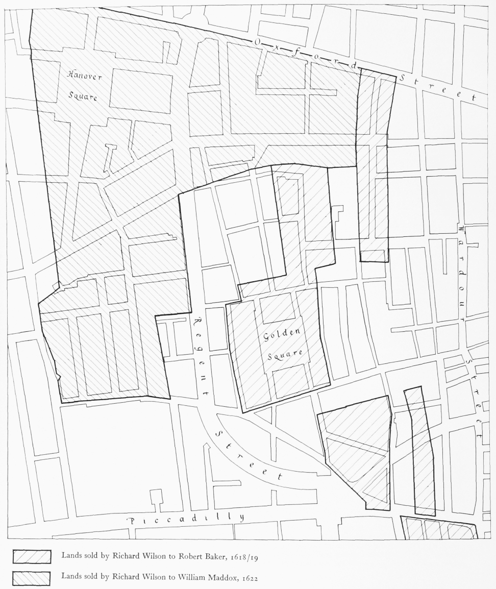
The hatched areas represent the lands which were granted in fee by the Crown to William Dodington in 1559/60, and which subsequently belonged to the Wilson family
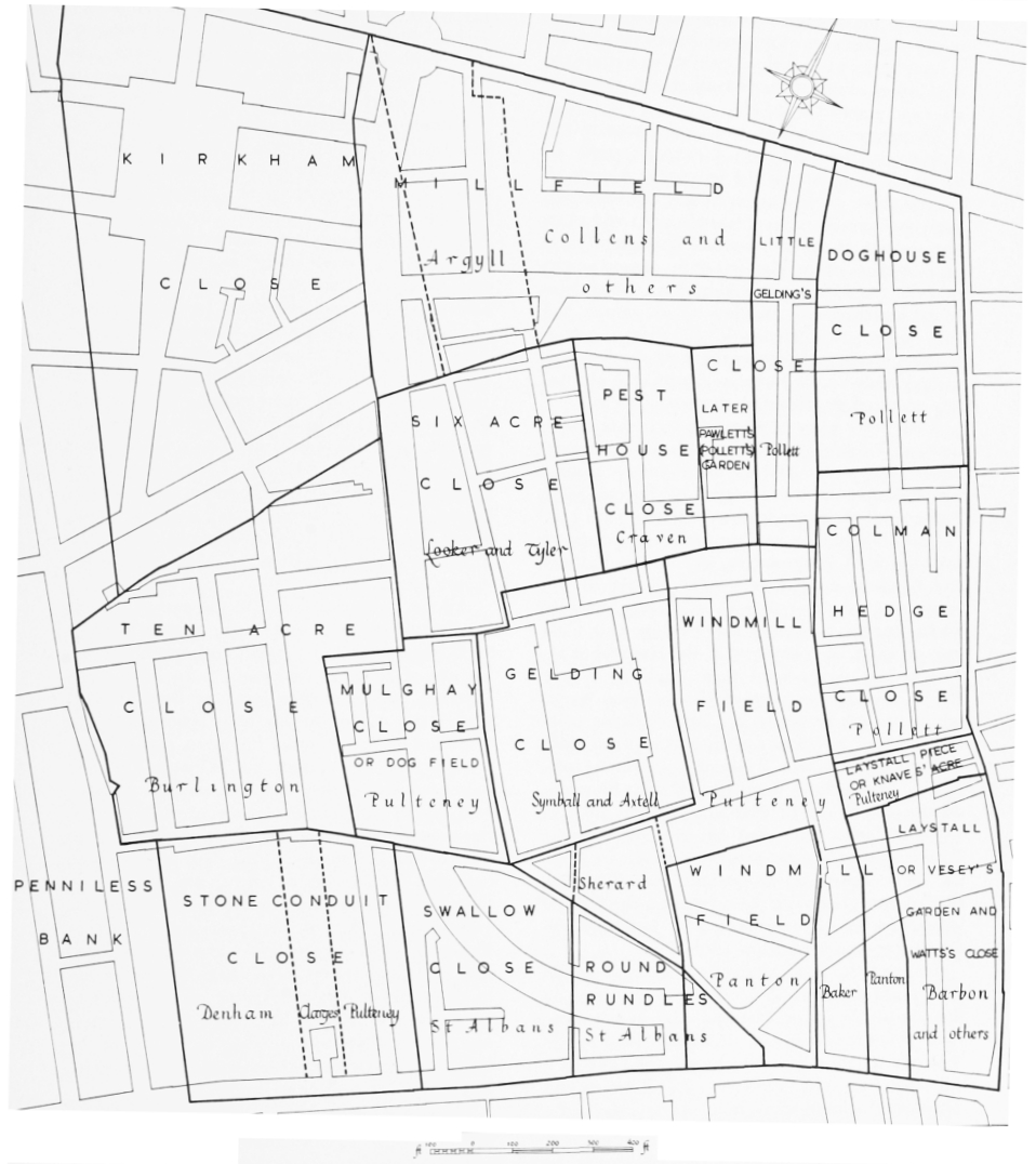
The sixteenth-century fields and their later developers. Broken lines represent approximate sub-divisions of the fields. Kirkham Close and Penniless Bank are in the parish of St. George, Hanover Square, and are not described in the present volumes
Dodington's freehold land had formerly belonged to the Mercers' Company until its surrender to Henry VIII in 1536. Almost all the rest of the ground under review had belonged, until its surrender to the Crown in 1531 and 1536 respectively, to the Provost and College of Eton (as custodians of the Hospital of St. James) and to the Abbot and Convent of Abingdon. All of these lands, together with Swallow Close, which had been acquired by Henry VIII from Thomas Hobson, (fn. 24) were subsequently held on lease at various times by the Pulteney family who ultimately acquired the freehold of some of them.
Two other plots, both on the west side of the modern Wardour Street at its north and southends, which were never held by the Pulteney family, had belonged to the Hospital of Burton Saint Lazar until their surrender to the Crown in 1536.
The Pulteney estate contained lands scattered over much of Westminster, and also in Fulham and Chelsea; an outline general history of the estate was given in Survey of London, volume XXIX, pp. 26–8. After the Provost and College of Eton, as custodians of the Hospital of St. James, had surrendered their lands to Henry VIII, the greater part of the demesne lands, which became known as St. James's Farm, continued to be leased as a unit, and at some time before 1575 Thomas Poultney became the subtenant. These lands were marked with his name on the plan of 1585 (Plate 1). Poultney died in 1581 and was succeeded by another Thomas Poultney, who was presumably his son. In 1590 the latter secured an assignment from Goma or Gomer van Osserwick (Osterwicke), the Crown lessee, of a reversionary lease of St. James's Farm for twenty-one years from 1608. (fn. 25)
In 1590 the lands which had belonged to the Abbot and Convent of Abingdon were leased by the Crown to James Harden, who in the same year assigned them to Thomas Poultney. (fn. 25) These lands are marked in the plan of 1585 by a light hatching and the letter A. This second Thomas Poultney died in c. 1607, leaving a widow, Ann, and a son, Michael. (fn. 26)
In 1610 St. James's Farm and the Abingdon lands, then in the possession of Michael Pulteney, were demised, together with other estates, by James I to John Eldred and William Whitmore for sixty years. (fn. 25) In March 1610 Eldred and Whitmore assigned their interest in the Abingdon lands to (Sir) Henry Hene in trust for Michael Pulteney (fn. 27) and in April of the same year they assigned their interest in St. James's Farm to Pulteney directly. (fn. 28)
In 1650 the estate was surveyed for the trustees for the sale of Crown lands (fn. 29) and this survey provides the earliest recognizable description of the fields of which it was composed. In the area under review they included Stone Conduit Close; Six Acre Close (not to be confused with the other Six Acre Close south of Piccadilly); (fn. 25) Windmill Field (including, but not mentioning, the Laystall Piece); a parcel of land to the north of this (the western parcel of Little Gelding's Close, later Pawlett's Garden); Mulguly Close (more commonly called Mulghay Close or Dog Field); Round Rundle or Rundles; and Swallow Close, which was found to have ceased to be part of the Pulteney estate in 1619. (fn. 5) These parcels are shown on fig. 2.
All the lands mentioned in the survey, except Swallow Close, were sold by the trustees in 1651 to Michael Pulteney's friend and agent, Samuel Stevens of Bray, in Berkshire. (fn. 30) In May 1652 Pulteney, who was then living at Bray himself, settled the estate for his own benefit and the benefit of his son Michael Pulteney, junior. (fn. 31)
After the Restoration Sir William Pulteney succeeded his brother Michael as their father's heir, and in 1661 obtained a reversionary term of twenty-one years after the expiry of the leases to Eldred and Whitmore. This new term, which extended his interest to 1691, was granted by Queen Henrietta Maria, the Bailiwick of St. James being part of her jointure. (fn. 25) Neither Round Rundles nor Swallow Close were included (the Pulteney interest in the latter having ceased in 1619), and after the expiry of the leases to Eldred and Whitmore in March 1669/70 these two parcels passed to the lessees of the rest of the bailiwick, who were the trustees of Henry Jermyn, Earl of St. Albans (fn. 32) (see Chapter IV).
During the reign of Charles II the practice of granting Crown lands in fee was resumed. In 1664 Sir William Pulteney gave up his leasehold interest in most of his land on the north side of Piccadilly in order that the Earl of Berkeley, the Earl of Clarendon and Sir John Denham might build themselves large houses there. (fn. 33) Stone Conduit Close formed part of the land surrendered to the King, and in the same year it was granted freehold to the Earl of Clarendon. (fn. 34) Immediately afterwards Pulteney re-acquired part of Stone Conduit Close from Clarendon; (fn. 35) this ground was therefore the first portion of their estate to be held by the Pulteney family in fee. The later history of these lands on the north side of Piccadilly is described in Chapters XXI–XXV.
In 1668 Sir William Pulteney was required to surrender another part of his lands to the Crown for the enlargement of St. James's Park and in recompense Charles II granted him a reversionary lease for thirty-four years from 1688/9 of most of the residue of his estate. This was the first occasion that a Pulteney had had a direct lease from the Crown. This grant, which extended Pulteney's interest to 1722/3, comprised Mulghay Close, Six Acre Close, Windmill Field and the Laystall Piece (or Knaves' Acre)—about twenty acres within the area covered by these volumes, as well as other lands elsewhere. (fn. 36) In 1670 Sir William sold his leasehold interest in part of Windmill Field to Ralph Wayne (Wain), who was acting on behalf of Francis Sherard (fn. 37) (see page 125). The Regent Palace Hotel now occupies the site of this ground, whose freehold is still owned by the Crown.
Two other parcels (both of which had formerly belonged, until their surrender in 1536, to the Hospital of Burton Saint Lazar) were granted in fee by the Crown in 1676 and 1698. Both of them were on the west side of the modern Wardour Street and both had been leased in 1661, as part of the bailiwick, by the trustees of Queen Henrietta Maria to the trustees of the Earl of St. Albans. (fn. 38) In 1676 Charles II granted to the latter the freehold of the more southerly, known variously as the Laystall, Vesey's Garden and Watts's Close and occupying the site of the modern Rupert Street, in exchange for the surrender by St. Albans of his leasehold interest in Nell Gwynne's house in Pall Mall (fn. 39) (see Chapter VIII). In 1698 William III granted the freehold of Doghouse Close, in the vicinity of D'Arblay Street (originally Portland Street), to William Bentinck, first Earl of Portland (fn. 40) (see Chapter XV).
After the death of Sir William Pulteney in 1691 his trustees, Sir Thomas Clarges and Henry Guy, were empowered to sell part of his estate to pay his debts and legacies. (fn. 41) In February 1692/3 the leasehold of the eastern part of Six Acre Close was sold to William Lowndes, (fn. 42) who obtained from the Crown a reversionary lease of ninety-nine years from 1722/3; (fn. 43) he subsequently purchased the reversion of the freehold. (fn. 44) In the western half of Six Acre Close Pulteney's principal subtenant, Lewis Maidwell, also obtained from the Crown a reversionary lease for ninety-nine years from 1722/3, (fn. 45) but the freehold was not subsequently sold, and (with the exception of the site of St. Thomas's Church, the freehold of which was granted to Dr. Thomas Tenison in 1692/3) (fn. 46) the ground still belongs to the Crown (see Chapter XI). In March 1692/3 the leasehold of the south-west quarter of Mulghay Close was sold to Nicholas Baxter (fn. 47) and the freehold of this, too, still belongs to the Crown (see Chapter XX).
In 1694 the leasehold interest held by Sir William Pulteney's trustees in some parts of the remainder of the estate was extended for ninetynine years from 1722/3 (fn. 48) while part of Windmill Field (around Great Pulteney Street, see Chapter IX) and Pawlett's Garden (a tongue of ground to the north of this) were granted to them in fee. The grant of the latter was made subject to a covenant that part of it should be set aside for a burial ground. (fn. 49) The parish workhouse was later built here (see Chapter XIII). In 1699 the leasehold of the Laystall Piece, on the south side of Brewer Street, and of the plot of ground to the west as far as Great Windmill Street, was sold to John Rowley, Yeoman of the Guard. (fn. 50) The freehold of both of these parcels belonged to the Crown until recently (see Chapter IX).
Sir William Pulteney's eldest son and heir, another William, died in 1715. He was succeeded by his eldest son and more famous namesake, the statesman, who later became Earl of Bath. (fn. 51) In 1721 an Act of Parliament enabled the Crown to grant to him the freehold of parts of the family estate, and in February 1721/2 Mulghay Close (with the exception of the south-west quarter) was granted to him in fee (fn. 52) (see Chapter XX), together with a rectangular plot at the south-east corner of Brewer and Sherwood Streets; the latter has subsequently been re-acquired by the Crown (see pages 117–18).
Lord Bath died in 1764, having been predeceased by his only son. The estate passed first to his brother, General Harry Pulteney, who died in 1767, and then to Frances, daughter of his first cousin Daniel. She married a William Johnstone who took the name of Pulteney and later became a baronet. Frances died in 1782 and left the London estates to trustees with benefits to her husband and their daughter, Henrietta Laura, later Countess of Bath. In default of Henrietta Laura's issue the estate was to go to Sir Richard Sutton and his heirs. (fn. 53) Sir Richard Sutton, the first baronet, was a lawyer and an under secretary of state from 1766 to 1772. In 1760 he had become a trustee of the marriage settlement between Frances Pulteney and William Johnstone and in 1772 became the trustee of the Pulteney estate which Frances had inherited from General Harry Pulteney. The Countess of Bath had married Sir James Murray, baronet (who added the name of Pulteney to his own), but she died without issue in 1808. Sir Richard Sutton died in 1802 and was succeeded by his grandson, Richard, an infant, and he, as the second baronet, inherited the Pulteney estate on the death of the Countess of Bath. (fn. 53)
During the nineteenth century the estate, now more accurately called the Sutton estate, underwent further changes. With the formation of Regent Street, which cut through part of the former Mulghay Close, the estate was divested of nearly all its property on either side of Swallow Street. This was surrendered to the Crown in 1823. (fn. 54) In 1830 an exchange of lands between the Crown and Sir Richard Sutton resulted in the acquisition to the estate of the freehold of land at the rear of houses on the east side of Little Windmill Street and of the triangular piece of land between Brewer Street, Glasshouse Street and Air Street. (fn. 55)
The Exclosure of Parish Lammas Lands
Much of the area described in this volume was Lammas land over which the parishioners had grazing rights from Lammas Day (1 August) until the spring. After the acquisition of almost all of the area by the Crown in 1531–6, the land was granted out on lease, or in the case of the grant to Dodington in 1559/60, in fee. The vague generalized phraseology in use in documents of title at that time was probably the main cause of the confusion which gave rise to the disputes (described on page 25) between James Bristow and Thomas Wilson. It is perhaps surprising that the testimony of the ancient inhabitants proved inconclusive in these disputes, but this was probably due to the blurring of old landmarks by the gradual enclosure of many of the fields between the modern Oxford Street and Piccadilly during the sixteenth century. A presentment made by the parishioners of St. Martin's in 1549 showed that enclosure on a considerable scale had taken place since the accession of Henry VII in 1485, and a survey made in 1575, shortly before the start of the dispute between Bristow and Wilson, includes (Little) Gelding's Close, the land in dispute, in a list of enclosures. (fn. 56)
In 1592 the inhabitants of the parishes of St. Martin and St. Margaret addressed a petition against the enclosures to William Cecil, Lord Burghley, as High Steward of Westminster. The latter ordered his under-steward 'to impanel an Inquest for Enquiry into this Matter, which seemed to favour' the petitioners. They, 'having, as they supposed, that Lord's Countenance, sent divers Persons on the 1. of August, being Lammasday, who, with Pickaxes, and such like Instruments, pulled down the Fences, and brake the Gates, having with them the Bailiffs and Constables, to keep the Peace'. On the following days the parishioners' cattle, guarded by a herdsman, were set to graze within the enclosures which had been thrown down, while the inhabitants ranged further westwards, peaceably destroying gates and fences towards Hyde Park and Chelsea. (fn. 57)
Shortly afterwards the tenants of the Bailiwick of St. James petitioned Burghley, stating that they had enjoyed their lands under the Crown 'Time out of Mind', and that if the destruction of their hedges were permitted 'all her Majesty's poor Tenants and Fermours were utterly undone'. In a counter-petition the inhabitants reiterated their claims to their ancient rights, and specifically mentioned 'Wilson, a Brewer' as an encloser. They alleged that the Queen 'greatly misliked' the enclosures, and that she had said that she only received eight pence an acre in rent for her lands and that her tenants 'abused her greatly therein. Whereupon she commanded some of the Tenants to be by the Lord Chamberlain committed to the Marshalsea: Which was done. And yet notwith-standing, they have proceeded to a farther Enclosure.' (fn. 57)
In February 1593/4 the vestry of the parish of St. Martin organized a collection to meet the costs of the defence of the common lands incurred in a suit started in the Courts of Queen's Bench and Exchequer by John Dawnson or Dauson, the tenant and encloser of part of the lands formerly belonging to the Hospital of Burton Saint Lazar. (fn. 58) The outcome of this suit is not known, but in 1598 the vestry appointed a herdsman to guard the parishioners' cattle grazing on the common land, 'to Use And Inioy it in As ampell maner as the Rest of or herdmen hertofore hath done'. (fn. 59)
In 1611–12 Robert Cecil, Earl of Salisbury, began to pay to the vestry an annual rent of fifty shillings for the right to build upon five acres of Lammas land at Swan Close, later Leicester Fields. (fn. 60) As building throughout the parish proceeded, this practice of paying rent for the right to build on Lammas land became increasingly common, (fn. 61) and continued until at least 1670. (fn. 62) The individual rents were, however, very small, and after changes of ownership the payments gradually ceased. It is worth noting that in the second half of the nineteenth century the vestry of St. Martin compiled an elaborate survey of the history of the parish Lammas lands, presumably in order to see if any of the rents could be reclaimed. (fn. 61)