An Inventory of the Historical Monuments in the County of Northamptonshire, Volume 3, Archaeological Sites in North-West Northamptonshire. Originally published by Her Majesty's Stationery Office, London, 1981.
This free content was digitised by double rekeying. All rights reserved.
'Hellidon', in An Inventory of the Historical Monuments in the County of Northamptonshire, Volume 3, Archaeological Sites in North-West Northamptonshire(London, 1981), British History Online https://www.british-history.ac.uk/rchme/northants/vol3/pp102-103 [accessed 30 April 2025].
'Hellidon', in An Inventory of the Historical Monuments in the County of Northamptonshire, Volume 3, Archaeological Sites in North-West Northamptonshire(London, 1981), British History Online, accessed April 30, 2025, https://www.british-history.ac.uk/rchme/northants/vol3/pp102-103.
"Hellidon". An Inventory of the Historical Monuments in the County of Northamptonshire, Volume 3, Archaeological Sites in North-West Northamptonshire. (London, 1981), British History Online. Web. 30 April 2025. https://www.british-history.ac.uk/rchme/northants/vol3/pp102-103.
In this section
37 HELLIDON
(OS 1: 10000a SP 55 NW, b SP 45 NE)
The roughly kite-shaped parish of about 640 hectares lies against the Warwickshire boundary, across the headwaters of a number of small streams which drain N. to form the R. Leam. The higher S. part is a fairly flat tableland on Marlstone Rock, between 180 m. and 190 m. above OD. This plateau is abruptly terminated by a steep and very indented scarp, through which the streams have cut valleys into the underlying Middle and Lower Lias Clays at between 120 m. and 165 m. above OD. Nothing of major archaeological interest is known in the parish, though the existence of the site of one of the two medieval manor houses (1) may help to explain the morphology of the village.
Medieval and Later
a(1) Manor house site (SP 517581; Fig. 81), lies immediately W. of Leam House, on limestone at 165 m. above OD. It is situated near the end of a N.-facing spur with extensive views to the N., E. and W.
Hellidon is not mentioned in Domesday Book, but from the 13th century onwards there appear to have been two main manors in the parish, one known as Giffords Manor and the other as Baskervilles. The two manor houses had some influence on the shape of the present village which consists of two conjoined loops with the church at the junction. Baskervilles Manor was on the site of the present manor house at the N.W. end of the village and W. of the W. loop. Giffords Manor is traditionally said to have stood on or near the existing earthworks in a field known as Woodhill, on the N. side of the E. loop (Whellan, Dir., 420–1); the site was abandoned by the late 18th century (NRO, Enclosure Map, c. 1775).
The remains consist of the N. part of a rectangular enclosure bounded by a degraded scarp only 0.25 m.–1 m. in height with, in places, traces of an inner bank. There is a small gap in the N.E. corner, partly blocked by another scarp which turns and runs E. down the hillside. The interior is uneven and disturbed by what appear to be quarry pits, though a sunken rectangular feature in the N.W. corner may be the site of a former building. On the E. a low bank, which extends down the hillside and which then returns S. as a slight scarp, is perhaps an outer and later enclosure (RAF VAP CPE/UK/1994, 1156–7; CUAP, AHG43).
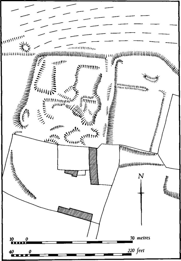
Fig. 81 Hellidon (1) Site of manor house
(2) Cultivation remains. The common fields of the parish were enclosed by an Act of Parliament of 1774 (NRO, Enclosure Map, c. 1775). Immediately before that date there were five large open fields surrounding the village. To the W. lay Hill Field, to the N.W. Lower Field and Further Field, to the N.E. Upper Field, and to the S. and S.E. Attle Field. On an earlier map of 1726 (NRO) Hill Field is called Middle Field and Attle Field is Short Attle Field. Ridge-and-furrow of these fields exists on the ground or can be traced on air photographs over much of the parish although it is markedly absent on the very steep slopes within and to the S. of the village, for example on Little Down Hill (SP 521578). Elsewhere it is mainly arranged in rectangular interlocked furlongs, often of reversed-S form. On the higher flat ground the furlongs run to the edges of the steep-sided valleys cut into the hillsides and rarely extend down the slopes (RAF VAP CPE/UK/1994, 1153–8, 1279–85).