An Inventory of the Historical Monuments in the County of Northamptonshire, Volume 3, Archaeological Sites in North-West Northamptonshire. Originally published by Her Majesty's Stationery Office, London, 1981.
This free content was digitised by double rekeying. All rights reserved.
'Sibbertoft', in An Inventory of the Historical Monuments in the County of Northamptonshire, Volume 3, Archaeological Sites in North-West Northamptonshire(London, 1981), British History Online https://www.british-history.ac.uk/rchme/northants/vol3/pp170-172 [accessed 30 April 2025].
'Sibbertoft', in An Inventory of the Historical Monuments in the County of Northamptonshire, Volume 3, Archaeological Sites in North-West Northamptonshire(London, 1981), British History Online, accessed April 30, 2025, https://www.british-history.ac.uk/rchme/northants/vol3/pp170-172.
"Sibbertoft". An Inventory of the Historical Monuments in the County of Northamptonshire, Volume 3, Archaeological Sites in North-West Northamptonshire. (London, 1981), British History Online. Web. 30 April 2025. https://www.british-history.ac.uk/rchme/northants/vol3/pp170-172.
In this section
55 SIBBERTOFT
(OS 1: 10000 SP 68 SE)
The parish covers almost 840 hectares. Its very short W. boundary follows the county boundary with Leicestershire. Most of the N. edge of the parish runs along the top of the steep N.-facing scarp of the Hothorpe Hills above the Welland valley, and the R. Welland itself rises from a spring in Sibbertoft village. The line of low rounded hills, deeply dissected by the steep-sided valleys of small streams, dominates the N. part of the parish; these hills are made up of Lower, Middle and Upper Lias Clay rising to a maximum height of 182 m. above OD. From there the land slopes gently S.W. and is almost entirely covered by Boulder Clay.
Apart from numerous scatters of Roman pottery, the major monument in the parish is the motte and bailey (8) known as Castle Yard, which is situated at a distance from the village commanding a steep-sided and narrow valley through the Hothorpe Hills. The village itself is of interest in that it appears to have had a completely new settlement on the W., added to the earlier one, probably in the medieval period.
Prehistoric and Roman
A polished stone axe has been found at SP 685812 (NM Records).
(1) Ditched trackway (SP 66988235–67128230), in the W. of the parish on Boulder Clay at about 155 m. above OD. Air photographs (in NMR) show a short length of ditched trackway, clearly visible for only about 150 m.
(2) Iron Age settlement (?) (SP 689835), N.E. of the village, on the edge of the Hothorpe Hills, on Middle Lias Clay, at 158 m. above OD. A scatter of Iron Age sherds has been noted (Northants. Archaeol., 12 (1977), 215).
(3) Roman settlement (?) (SP 686834), 200 m. S.W. of (2), in a similar situation. Roman pottery has been found (Northants. Archaeol., 12 (1977), 215).
(4) Roman settlement (?) (SP 677832), N.W. of the village, in a situation similar to (2) and (3). Roman sherds are recorded (Northants. Archaeol., 12 (1977), 215; grid ref. incorrect).
(5) Roman settlement (?) (SP 670825), W. of the village, 200 m. N. of (1) on Boulder Clay at 155 m. above OD. Roman pottery has been discovered (Northants. Archaeol., 12 (1977), 215).
(6) Roman settlement (?) (SP 665835), in the N.W. of the parish, on Boulder Clay, at 180 m. above OD. Roman sherds have been noted (Northants. Archaeol., 12 (1977), 215).
(7) Roman settlement (?) (SP 660835), in the extreme N.W. of the parish, on Middle Lias Clay, at 152 m. above OD. A small scatter of Roman grey ware has been found (Northants. Archaeol., 11 (1976), 193).
Medieval and Later
(8) Motte and bailey (SP 609831; Fig. 130), known as Castle Yard, lies on the end of a N.-projecting spur, between two streams cut deeply into the Middle Lias clays and silts, at about 155m. above OD. It is in a position of considerable tactical strength, commanding the assumed ancient trackways through the valley below. Nothing is known of its history, though it perhaps dates from between the late 11th and the mid 12th century. Its situation is surprisingly remote from any known medieval settlement.
The motte, standing on the edge of the spur, is roughly circular and rises some 2 m. above the ground to the S. The summit slopes slightly up to the N. and at its N. end stands the foundations of a modern structure. The motte is bounded on the S. by a broad ditch up to 2.5 m. deep and on the N. by a narrow ledge, with traces of an outer bank only 0.25 m. high above the precipitous natural slope.
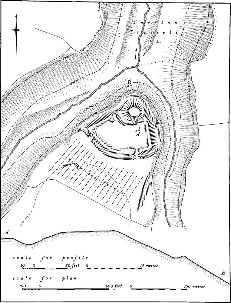
Fig. 130 Sibbertoft (8) Motte and bailey
The bailey is set on the flat ground to the S. of the motte; it is bounded on the S. by a broad ditch, up to 1 m. deep from the outside, with a flat-topped inner bank up to 0.5 m. high. At each end the ditch runs down to the natural valley side, but the bank returns to meet the ditch of the motte. Below this the ledge which encircles the N. side of the motte continues some 3 m. below the bank.
Beyond the bailey ditch to the S. is a block of very flat ridge-and-furrow which seems to have ended on the line of the present hedge. No finds have been made on the site (VCH Northants., II (1906), 411–2; plan of 1884, Dryden Collection, Central Library, Northampton).
(9) Settlement remains (centred SP 675827, 676829, 681828; Figs. 13 and 131; Plate 11), lie in and around the modern village on clays, silts and alluvium at about 165 m. above OD. The village appears once to have consisted of two separate parts, an impression confirmed by the name Westhorpe given to the N.–S. street to the W. of the main part of the village, but there is no documentary evidence bearing on this. Apart from two small groups of earthworks in the S.E. and N.E. ('a' and 'b' on plan), some of which may be house-sites, the surviving settlement remains are concentrated at the W. end of the village in the area called Westhorpe. However other remains may have been destroyed by the extensive 19th and 20th-century housing and indeed there are records of medieval pottery in that part of the village which has now been redeveloped (SP 678827; Northants. Archaeol., 9 (1974), 110).
On the W. side of Westhorpe there were former houses to both N. and S. of the existing buildings; building platforms and part of the outer boundary of the closes are still visible ('c' and 'd' on plan). Closes also exist on the S. side of the E.–W. road leading towards the main part of the village ('e' on plan). The symmetry of these closes and the L-shaped layout along two straight lengths of road, as well as the name, implies that Westhorpe may have been a planned extension of the main village. No date for the abandonment of these earthworks has been established.
In the field immediately W. of Westhorpe ('f' on plan) there are two large irregular mounds surrounded by an area of disturbed ground, and a shallow ditch or hollow-way runs E. from the S. side of the mounds towards the village. On the Tithe Map of 1841 (NRO) a roughly circular pond, some 60 m. in diam., with a circular island inside it is shown in this field. It has a narrow extension to the E. which is probably the feature which now survives as a dry channel. A large building is shown immediately S. of this canal, close to the existing road and the N. part of the field was then known as the Coombe and the S. part as Water Loggs. The pond may have been an ornamental feature, perhaps part of a garden.
In the S.E. of the village (SP 67958245) is an area called a green in both 1787 and 1841 (Maps in NRO). On the later map a hedge is shown on the S.W. side of the green and this appears to follow the line, on the ground, of a steep scarp 1.5 m. high above which the ridge-and-furrow terminates. The scarp may therefore be the boundary of the green (RAF VAP 106G/UK/636, 3134–5; CPE/UK/2109, 4297–9; CUAP, BAP69, 70).
(10) Mound (SP 69258263), known as Moot Hill, in the E. of the parish on Boulder Clay at 182 m. above OD. The mound, which is now destroyed, was described as a tumulus on early and also on modern OS maps. It may have been a spoil heap from a nearby pond (OS Record Cards).
(11) Cultivation remains. All that remained of the common fields of Sibbertoft was enclosed by agreement in 1650, but part of the parish was already apparently in old enclosures before that date (J. Bridges, Hist. of Northants., II (1791), 73). In 1506 an indenture for the sale of Sibbertoft Manor listed only 300 acres of arable land whereas there were 200 acres of meadow and 1000 acres of pasture (Cal. Close, 1500–1509, 573), indicating that the earlier enclosure had already taken place by the beginning of the 16th century.
Ridge-and-furrow of these fields survives on the ground or can be traced on air photographs over almost the entire parish, with the exception of a small area in the N.W. Much of it is well preserved still. On the flatter ground in the S.W. it is mainly arranged in end-on furlongs running N.–S. and this orientation is also frequent in the N. though here the irregularity of the Hothorpe Hills has led to interlocking of the furlongs as they are adapted to changes in direction of slope (RAF VAP 106G/UK/636, 4133–9, 3132–7; CPE/UK/2109, 4295–4302, 3297–3302).