A History of the County of Wiltshire: Volume 8, Warminster, Westbury and Whorwellsdown Hundreds. Originally published by Victoria County History, London, 1965.
This free content was digitised by double rekeying. All rights reserved.
'Westbury: Introduction', in A History of the County of Wiltshire: Volume 8, Warminster, Westbury and Whorwellsdown Hundreds(London, 1965), British History Online https://www.british-history.ac.uk/vch/wilts/vol8/pp139-148 [accessed 1 May 2025].
'Westbury: Introduction', in A History of the County of Wiltshire: Volume 8, Warminster, Westbury and Whorwellsdown Hundreds(London, 1965), British History Online, accessed May 1, 2025, https://www.british-history.ac.uk/vch/wilts/vol8/pp139-148.
"Westbury: Introduction". A History of the County of Wiltshire: Volume 8, Warminster, Westbury and Whorwellsdown Hundreds. (London, 1965), British History Online. Web. 1 May 2025. https://www.british-history.ac.uk/vch/wilts/vol8/pp139-148.
WESTBURY
The ancient parish of Westbury (fn. 1) was co-extensive with the hundred. (fn. 2) It was roughly crescent-shaped, stretching some seven miles from east to west, and approximately four miles from north to south, and included within its bounds were the later civil parishes of Bratton, Dilton Marsh, Heywood, and part of Chapmanslade. It remained a single parish, with the town of Westbury roughly in the centre, until the late 19th century, but a number of other centres of settlement are early discernible, some of which were as large as many rural parishes. In 1334 there were besides the town of Westbury eleven vills or tithings liable for taxation. These were Bratton, Melbourne, and Stoke in the east, Hawkeridge and Heywood in the north, Brook, Penleigh, Bremeridge, Dilton Marsh, and Westbury Leigh in the west and south, and Chapmanslade in the extreme southwest corner. (fn. 3) Of these Melbourne and Stoke became merged in Bratton; (fn. 4) Bremeridge was coupled with Dilton Marsh in 1377 and has not been found to occur again as a separate tithing; Brook continued to constitute a separate area for the purposes of taxation until the 17th century. Westbury Leigh was probably a suburb of Westbury town from early times, but it retained its separate identity as a fiscal and administrative unit until the 19th century; Penleigh remained a distinct hamlet or tithing until the end of the 17th century when it was divided into Upper and Lower Penleigh. By the 19th century, however, it probably comprised little more than Penleigh House and Farm and a few farm cottages. Bratton, Heywood, Hawkeridge, and Chapmanslade survived as distinct centres of population. In the 14th century both Dilton, which had a church and was a chapelry of Westbury, (fn. 5) and Dilton Marsh were centres of population for taxation purposes, but for some centuries afterwards Dilton seems to have been more important than Dilton Marsh. By the beginning of the 19th century, however, Dilton was a mere hamlet and Dilton Marsh the more populous district with a thriving weaving industry. (fn. 6)
In the 16th century the town of Westbury was divided for purposes of taxation into the tithing of the precentor, or 'chantry', which lay around and to the south of the church, and the town and the borough of Westbury, which were not co-extensive. (fn. 7) The borough of Westbury, it seems from later evidence, was the part of the urban area in which the burgage tenements lay. (fn. 8) The first evidence found for the location of the burgages occurs in 1777 when there were 61 distributed among 10 manors or lesser estates, all part of the capital manor of Westbury. These estates were Westbury Arundell, Seymour, and Stourton, Heywood, Hawkeridge, Brook with Mauduits, Westbury Leversage, Leigh Priors, Leigh Marsh (Westbury Leigh), and Bremeridge. (fn. 9) As is shown below, (fn. 10) these estates were made up of lands scattered throughout the ancient parish, and the burgages must have been in those parts which were situated in, or converged upon, the town. In 1835 it was reported that the burgages lay in three separate areas of the urban area, namely around the Market Place, in the vicinity of Eden Vale, and at a place called the Knoll, which lay between the southern end of Church Street and the Warminster road. (fn. 11)
Outside the urban area a tithing of Bayly is mentioned in the 16th century. This does not, so far as is known, occur in the 17th century, but in 1645 Hawkeridge is divided into two parts: 'Bailief Hawkeridge' and 'Priorie Hawkeridge', and Westbury Leigh is divided into 'the Bailief of Leigh' and 'the Tithing of Leigh' which suggests that the former tithing of Bayly may have been formed out of parts of Hawkeridge and Westbury Leigh. (fn. 12) In 1542 the tithing of Short Street,lying between Dilton Marsh and Chapmanslade, was coupled with Chapmanslade, and later, on one or two occasions, appeared as a tithing on its own. (fn. 13) The freehold book of 1736 possibly affords a very rough indication of the importance of the various areas of settlement at that date. The names of the more substantial free-, lease- and copyholders were collected for 12 places within the ancient parish. Brook, Dilton, and Hawkeridge returned no names. Heywood and Short Street returned one each; Westbury Leigh and Penleigh 3; Chapmanslade and the tithing of Chantry 5; the borough of Westbury 8, the 'Bailief of Leigh' 10, and Bratton 17. (fn. 14)
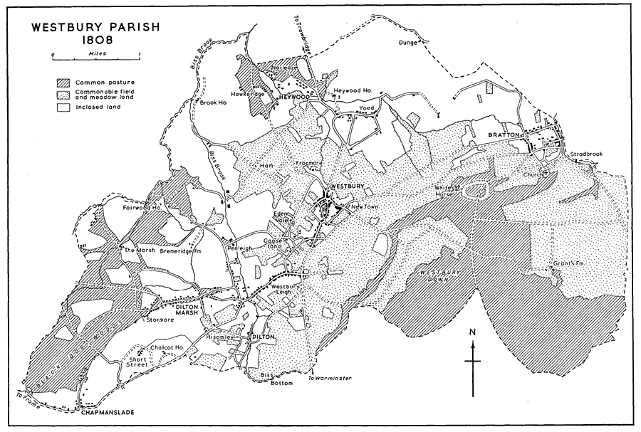
Westbury Parish 1808
This map is based on the inclosure award map
In 1882 the area of the ancient parish was very slightly increased when Hisomley Farm, previously a detached part of Upton Scudamore, was trans ferred to Westbury. (fn. 15) In 1894, however, the ancient parish was split up with the formation of the three separate civil parishes of Westbury, Bratton, and Dilton Marsh. (fn. 16) Two years later the civil parish of Heywood was created out of the northern part of the civil parish of Westbury. (fn. 17) The civil parish of Chapmanslade was created in 1934 when parts of Dilton Marsh, Corsley, and Upton Scudamore were taken to form it. (fn. 18) In 1899 the civil parish of Westbury was constituted an urban district retaining the same boundaries. (fn. 19) These were slightly enlarged in 1909 by the addition of a part of the parish of Heywood. (fn. 20) In 1951 the area of the urban district, which is roughly square in shape, was 3,686 a. (fn. 21)
The town of Westbury lies in the centre of the urban district on the strip of upper greensand, which runs beneath the north-western escarpment of Salisbury Plain, and divides the chalk uplands in the south-east of the urban district from the gault and Kimmeridge clay in the north-west. (fn. 22) On the chalk uplands in the south-east a height of over 700 ft. is reached, but beneath the escarpment in the rest of the urban district the land nowhere rises much above 250 ft. From its position beneath Salisbury Plain the town has sometimes been called Westbury-under-the-Plain. (fn. 23)
Biss Brook, which later becomes the River Biss, forms the western boundary of the urban district. To the east and south of the town, along the foot of the steep chalk downs, there are numerous springs and wells. A spring rising at Wellhead to the south of the town runs westwards to join the Biss Brook. Bitham Brook also rising from a spring in the town runs northwards. (fn. 24) In the north-west corner of the urban district, in the district called the Ham, there is a chain of lakes and ponds formed by the waterfilled iron-ore workings abandoned after the First World War. (fn. 25) The only woodland in the urban district lies at the foot of the chalk downs to the south-east of the town.
The main road from Trowbridge to Warminster runs from north to south through the centre of the urban district. This forms the town's main street passing through the Market Place, continuing as Maristow Street, and Edward Street, and leaving as the Warminster Road. A secondary road running from West Lavington under the escarpment of Salisbury Plain passes through Bratton and joins the main Trowbridge-Warminster road in the town. Another secondary road leaves the main road in a westerly direction at the southern end of the town. The roads to Westbury from Trowbridge and from Market Lavington were turnpiked in 1758, as was a road now (1960) a mere track, which led over Westbury Hill via Bowls Barrow to Chitterne. (fn. 26) The road leaving the town for Warminster was turnpiked in 1769. (fn. 27) A toll-house at Chalford on this road survived in 1960.
The railway station lies at the Ham in the northwest of the urban district, nearly a mile from the centre of the town. It was opened in 1848 when the line was brought to Westbury through Trowbridge from Thingley on the main line from London to Bristol. (fn. 28) The line running westwards from the the station towards Frome was opened in 1850 as the first stretch of the line from Westbury to Weymouth. (fn. 29) The first part of the line running south from the station through Warminster to Salisbury was opened the following year. (fn. 30) In 1900 the line running eastwards to join the main line from London to Bristol at Patney and Chirton was opened and later became part of the main route from London to Taunton and the west of England. (fn. 31) There are also two loop-lines by-passing the station: the first made in 1933 for trains on the route from London to the west of England; (fn. 32) the second made in 1942 for trains travelling between Trowbridge and Reading. (fn. 33)
The town of Westbury is nearly a mile to the south-east of the site of a Romano-British settlement at the Ham. (fn. 34) The oldest part of the present town lies in and around the roughly triangularshaped area formed by West End (formerly Cheap Street), Edward Street, Bratton Road, and Alfred (formerly Duck) Street. Within this area lies the Market Place, the church, Angel and Bitham Mills, and, until the late 19th century, a considerable part of the southern end of it was occupied by Church or Parsonage Farm. (fn. 35) Most of the houses in this area appear to be of 18th- or early 19th-century date, but in many cases re-fronting done in those centuries must obscure earlier buildings of stone or timber-framing. Interspersed with these, and sometimes lining such streets as West End, Edward, and Fore Streets, are many rows of workers' cottages dating from the 18th and early 19th centuries. Many of the 19th-century houses are roofed with pantiles, probably made locally.
The Market Place, in which no markets have been held since the middle of the 19th century, (fn. 36) lies in the north-west corner of the area. Many of the houses flanking it were converted into shops in the 19th century. The 'Lopes Arms' on the east side is an apparently 18th-century building. Between c. 1754 and 1809 it was the 'Lord Abingdon Arms', and it may stand on the site of an inn called 'St. George and the Dragon' in the 16th century. (fn. 37) The 'Crown' and the 'White Hart' on the west side of the Market Place are 18th-century buildings, but probably have not such long histories as inns. The Market Hall on the east side was presented to the town by Sir Manesseh Massey Lopes in 1815. (fn. 38) It is built of Bath stone and has a colonnaded ground floor of 3 bays. The upper floor also has 3 bays and in the central one is an arched panel with a clock face. Above this is a pediment with the Lopes arms carved in stone in the tympanum. It was used for a time as a Town Hall, and as long as county courts were held in Westbury, they sat here, (fn. 39) but in 1960 the upper part was used only for a branch of the County Library. At the southwest corner, where Maristow Street leaves the Market Place, stands the Manor House, occupied occasionally by Sir Manesseh Lopes after he acquired the manor in 1810. (fn. 40) It is a late Georgian house with two stories and attics. Over the frontdoor is a semi-circular stone porch supported by two Tuscan columns. To the left of this a shopwindow has been inserted. Between the Manor House and the church there is a terrace of doublefronted houses of about the same date set behind front gardens.
There are two other medium-sized residential houses in the neighbourhood of the Market Place which are comparatively unaltered. Bank House, called for a time in the 1940's Marlborough House, in West End, facing into the Market Place, is an early-18th-century brick building of 5 bays with stone dressings, a moulded eaves-cornice, and a steeply pitched hipped roof. Above the central doorway is a shell hood on foliated brackets and internally there is a contemporary staircase. In 1960 it was the bank house of a branch of Barclays Bank. The other house of some size lies in Alfred Street as it leads eastwards out of the Market Place. At the end of the 19th century it was called Ferndale, and is thought locally to have been once the rectory house. (fn. 41) It is a stone house, perhaps of 17th-century date. Its two-storied brick front, however, is of the mid-18th century with stone Venetian windows and Gothic glazing-bars. It stands in fairly extensive grounds for a town house.
The church of All Saints lies south of the Market Place. The churchyard is inclosed by brick walls and by some cottages of 18th- and early 19thcentury date, which face the church, and by contrast give it height. The tithing of Chantry lay to the south and east of the church. Through it, running south from the church, winds Church Street, a narrow street, with three even narrower ways or footpaths leading off its east side. At the north end of the street there is a tall early-19thcentury brick house, with an older rear wing facing the churchyard. This has a stone gable-end containing a two-light medieval window, and the firstfloor room has an arch-braced collar-beam roof, probably also of late medieval date. This may possibly represent part of a house once used by the Precentors of Salisbury who held the rectory and exercised peculiar jurisdiction in the parish. (fn. 42) In the southern part of the tithing of Chantry, within the area inclosed by Church and Edward Streets, Bratton Road, and the footpath called Chantry Lane, was Church or Parsonage Farm. The farmhouse and buildings are shown on a map of 1899. (fn. 43) Fields, called Chantry Lease, belonging to the farm lay some two miles away, north of the lower road to Bratton, a mere track in 1960. (fn. 44) Shortly after 1870 the farm ceased to be worked as such, and much of the site was used for allotments. (fn. 45) In 1960 some of the land was being built over, but some of it was still open and was used for a builder's yard and as allotments. Two houses with modernized frontages on the east side of Church Street, called Little Chantry, were formerly part of the farm buildings. On the same side of the street and at its southern end are two medium-sized 18th-century houses, both with some features of distinction.
Opposite the site of the former Chantry Farm, and in the angle formed by the junction of Church and Edward Streets, lies the Angel Cloth Mill. Bitham Cloth Mill lies to the north-east and abuts on to Bitham Lane and Alfred Street. (fn. 46)
There are a number of 18th-century houses along Maristow and Edward Streets, and the beginning of the Warminster road. Some are medium-sized town residences, and have been little altered, but many of the smaller houses have been converted into shops. Westbury House, in Edward Street, is a red-brick house built in the early 19th century with later additions. In the 19th century it was the home of the Laverton family until 1888 when William Henry Laverton bought Leighton House. (fn. 47) In 1960 an extension on the north side of the house was used by C. Rickards, Ltd., Umbrella Manufacturers. (fn. 48) Fontainville House, once the home of the Jefferies family, stood in a large garden nearly opposite Westbury House and was of approximately the same date. It was built of Bath stone, and had some distinguished architectural features, including a Doric porch and a balcony above with wrought-iron rails of lattice pattern. In 1959, however, the house was a ruin, and in 1961 it was pulled down to make way for a new shopping precinct. Number 24 Warminster Road is an early-19thcentury stone house now partly converted into a shop. It has a three-storied ashlar front and its 5 bays are divided by pilasters with incised line ornament. The Greek revival influence is evident in the honeysuckle ornament and the acroteria of its top story.
In Bratton Road, near the junction with Warminster Road, there is a two-storied building with timber-framed upper part of different dates. This was formerly called Bere's Well, and a spring rising beneath it is carried under Bratton Road and by underground conduit down Church Street. (fn. 49)
Besides the small group of 18th-century houses at the beginning of Warminster Road there are a few further south, but a map of 1773 shows that at that time the town extended no further south than the junction with Leigh Road, formerly Lower Road. (fn. 50) This point was, indeed, called 'Townend'. (fn. 51) Between this point and the hamlet of Chalford there is a medium-sized late-18th-century house built of brick surrounded by a large garden. This was formerly called Hill Tyning (fn. 52) and since the Second World War has been the Cedars Country Club Hotel. Beyond this, standing in its park, is Leighton House built in 1800. (fn. 53) In the 18th century the park was divided into two parts by the road which turns west off the main Westbury-Warminster Road, called in 1960 Laverton Road. In the part lying south of Laverton Road was Leigh House which was abandoned after Leighton House was built in the northern part of the park. At the junction of the two roads is the hamlet of Chalford.
Parallel with Warminster Road, and about ¼ mile to the west, is the district known as Eden Vale. There are a few 18th-century houses here, and the Westbury Union Workhouse was established here in the early 19th century. An earlier workhouse, built at the end of the 18th century, is probably represented by the front range of the present building which has alterations and additions of c. 1835. (fn. 54) In 1960 the workhouse was used as the offices and yard of T. Holdoway & Sons, Builders. The Indigo Factory, or Dye House, was built in this district in the early 19th century, and throughout that century there were considerable brick works here, which are now abandoned. The map of 1773 also shows some building at the beginning of the road leading off the Bratton road and over the downs towards Chitterne. (fn. 55) Even at that date the district was called New Town, and may have been designed as a new housing scheme to meet the needs of the prosperous 18th-century town. A few 18th-century cottages remain on the south side of the road, but there is nothing to show that the site was ever further developed.
Several of the town's public buildings bear witness to the revival of the cloth industry and the position of the Laverton family in Westbury in the later 19th century. The Laverton Institute, built by Abraham Laverton, is a red-brick building in Gothic revival style in Bratton Road opened in 1873. It was originally used for recreational and cultural activities, and for a time housed a British School for boys, but since 1899 it has been the offices of the Urban District Council. (fn. 56) Abraham Laverton also laid out Prospect Square on the south side of Bratton Road. This comprises 39 houses, of which seven are almshouses, built of brick and stone round three sides of an open space used as allotment gardens. (fn. 57) William Henry Laverton built the public baths in Church Street in 1887, and the Technical School of Science and Art in the same street in 1897. (fn. 58)
In the 20th century there has been a certain amount of building on the east side of the town where the upper greensand gives way to the chalk. Small detached houses and bungalows have been built along the Butts and Bratton Road, and around New Town. Much of the town's expansion, however, has been westwards towards the station and along Eden Vale and Leigh Road to the west of the Warminster road. In addition to the railway workshops, several of Westbury's industries are situated in the region of the station. (fn. 59) The Avenue, and the Crescent, the council's housing estates built between the two World Wars, and the Old Field Park council housing estate, built after the Second World War, all lie on the west of the town. (fn. 60)
Westbury Leigh lies within the urban district of Westbury about a mile from the centre of the town. Like Westbury, it is situated on the upper greensand strip at the foot of Salisbury Plain. (fn. 61) The houses are built close to the road and extend along it for about ½ mile. They include several dating from the 18th century. At the north-east end of the street no. 18 has a red-brick front with stone dressings which apparently dates from the earlier 18th century, but has Victorian alterations. It is of 2 stories and 5 bays and has round-headed windows to the first floor. Above the central doorway is a scrolled pediment. The gloving factory of Messrs. Boulton Bros. is at the same end of the village, standing back from the road, and occupying as part of its premises the mill called Balls Mill in the later 19th century. (fn. 62) Westwards along the street, on its south side, the malthouse of Messrs. Samuel Thompson & Sons is an early19th-century building, probably on the site of a considerably older malthouse. (fn. 63) The church was built on the north side of the street in the late 19th century. Three blocks of council houses have been built on the same side of the street since the Second World War. The nearby 'Phipps Arms' dates from the early 19th century. Just north of the road, and not far from the track leading across the fields from Westbury to Penleigh House, (fn. 64) is a moated site, traditionally called Palace Garden.
Dilton, locally called Old Dilton, lies about ¾ mile south-west of Westbury Leigh on the boundary between Westbury Urban District and the parish of Dilton Marsh. It is a mere hamlet consisting of the church of St. Mary, Dilton Farm, and a few cottages situated in, and on the sides of, the valley of the Biss Brook, which is here quite steep. A minor road running between the secondary road from Westbury to Chapmanslade and the main road from Westbury to Warminster winds through the hamlet.
The civil parish of BRATTON was created in 1894 out of the eastern part of the ancient parish of Westbury. (fn. 65) It comprises 3,695 a. (fn. 66) and is the long, narrow shape, typical of the 'springline parish'. (fn. 67) About "2/3 of the parish lies on the chalk downs of Salisbury Plain, which rise steeply south of the village to over 750 ft. near the Iron Age camp at Bratton Castle. Until the end of the 19th century there were three or four substantial farms on the slopes of the Plain, but in 1960 much of this area belonged to the War Department. The northern end of the parish is clay-land and low-lying. The village of Bratton is situated in the extreme east of the parish at a height of about 300 ft. on the strip of upper greensand dividing chalk and clay. (fn. 68) A small stream, called the Milbourne in the Middle Ages, and locally sometimes called the Bratt, (fn. 69) forms part of the eastern boundary of the parish and on this were a number of mills. (fn. 70) Church Spring, rising just south of the church, flows round it on the west side and down to join the larger stream. The only woodlands in the parish are the clumps of beech trees scattered here and there on the downs, but the thick hedges on high banks, and the numerous small ochards in and around the village create a well-wooded effect. (fn. 71)
The secondary road from West Lavington to Westbury runs through the parish at the foot of the downs. For its course through the village it is called Melbourne Street. This is joined at the western end of the village by a secondary road from Steeple Ashton in the north, and a former toll-house stands at the junction of the two roads. A minor road turns west off this road from Steeple Ashton and runs across the parish to Heywood. A road from the village of Bratton running south-westwards over the top of the downs to join a road from Westbury to Chitterne was turnpiked between 1751 and 1775. (fn. 72) In 1960 this was a mere track, as was the road running from Bratton to Westbury just north of the present secondary road, and known as Westbury Lower Road. The railway line from Westbury to Patney and Chirton passes through the northern part of the parish. The station of Edington and Bratton lies in the parish of Edington, but was closed to passengers in 1952. (fn. 73)
The village lies roughly round an incomplete circle of roads and along Melbourne Street, which runs through the middle. On either side of this street there was originally space for orchards and allotments, but in the 20th century this has been encroached upon by private building and a council estate built c. 1922. More recent building has extended the village westwards, and here there is another council estate built in 1948–9. The church lies ¼ mile to the south of the centre of the village on the steep slopes of the downs. (fn. 74)
In the early 19th century Bratton was still said to be made up of the three tithings of Stoke, Melbourne, and Bratton, (fn. 75) which existed in the 14th century and probably much earlier. (fn. 76) There was also another tithing, or estate, called Headinghill. (fn. 77) The first mention found of this is in 1166 and in the 13th and 14th centuries it emerges as an important member of the manor of Westbury. (fn. 78) It is mentioned with other lands in Bratton in a 16th-century suit, (fn. 79) and was assessed under Bratton for land tax in the 18th century, (fn. 80) and for church rates in the 17th and 18th centuries. (fn. 81) It has not, however, been precisely located. In 1960 the three separate settlements of Stoke, Melbourne, and Bratton were still distinguishable. Stoke, or Little Stoke, lay around the church, (fn. 82) so that the church probably once lay in the centre of a village, or hamlet, not, as now, on the fringe. Melbourne lay along the stream as it flows from the point called Stradbrook, and along Melbourne Street. Bratton is thought to have been the district around the Court House (fn. 83) which stands at the junction of Lower Road and Court Lane. This ho e was probably once the court house of the manor of Bratton which descended to the Marquesses of Bath. It formed part of Lord Bath's estate in 1840. (fn. 84) Just north of the Court House there are traces in a field of a moated site, probably of medieval date, thought locally to have been the site of the manor house of the same manor. (fn. 85) Traces of a moat are also to be seen at Dunge Farm, an 18th-century farm house about a mile to the north-west of the Court House.
The Court House is a timber-framed building with a thatched roof, standing on a stone base. Infilling between the timbers is of wattle and daub, partly replaced by brick. The structure is of several periods and its evolution is difficult to trace. It consists of a principal range parallel to the road with a cross wing at its north end; there are comparatively modern additions at the rear and at one time the building was divided into several cottages. A single cruck blade in a cross wall, near the centre of the principal range indicates that this part of the house was originally a single-storied structure of medieval date. The cross wing, which has close studding and a jettied first floor at the gable end, may be an early 16th-century addition. The principal or 'hall' block was later remodelled and raised to two stories, probably in 1626, a date which is carved on a bracket supporting the ceiling in the present central room. Moulded and carved fireplaces here and in the room above appear to be of the same period. The present front door, immediately south of the central room, has a lintel dated 1656. It is approached by a contemporary timber porch with turned balusters and the whole south end of the range may have been built, or rebuilt, at this time.
Bratton contains a high proportion of old houses of many periods, showing the use of a wide variety of building materials. In addition to the Court House, timber-framed examples include Ivy Cottage, Yew Tree Farm, and a derelict cottage (all in Lower Road), Court Lane Farm, and several houses at the south-east corner of the village. Most of these appear to date from the 16th and early 17th centuries; in some cases their thatched roofs have been replaced by slate. On the south side of Melbourne Street one of the few stone houses in the village has a thatched roof and a door lintel dated 1621; the adjoining cottage was formerly timber-framed. The village also contains a notable number of small farm houses and medium-sized dwelling houses of the later 17th and 18th centuries. These are built of brick with stone dressings and several have considerable architectural character. The Manor House, partly of the 17th century, is an example. (fn. 86) Rosenhime Farm has a symmetrical front, a central gabled porch, and stone mullioned windows with drip moulds; its thatched roof was raised and tiled in 1962. The Poplars in Court Lane and Fir Tree Cottage in Lower Road date from the early 18th century and have twolight stone mullioned windows without drip moulds. (fn. 87) Ivydene in Lower Road is a much altered house of the same period. The older part of Grange Farm is dated 1739 and Scotts Farm is a somewhat similar house with a stone-slated roof. (fn. 88) A tall thatched house to the north of the Court House with a symmetrical brick front was formerly timber-framed; the brick alterations and additions date from the 18th century. Ballards, next to Scotts Farm, is a later 18th-century example with 19th-century additions.
There are also some larger 18th-century houses of which the most important is Bratton House in Melbourne Street, home of the Ballard family until the 19th century. (fn. 89) Melbourne House in Melbourne Street, built of red brick with stone dressings, has a two-storied front and a hipped roof of stone slates with dormer windows. The central doorway is surmounted by a stone hood on moulded brackets and above it is a pedimented window. Flanking these are three-light windows with raised central lights. The initials 'WW' and date '1768' are inscribed on a chimney stack and the same date appears on the wall enclosing the forecourt. Yew Trees in Lower Road consists of two distinct parts, each with a symmetrical 18th-century brick front. Between 1718 and c. 1789 members of the Whitaker family conducted a boarding school for boys in the house, and it was here, under the leadership of the Whitakers, that the early meetings of the Baptists were held before their chapel was built. (fn. 90) The school continued for many years after the retirement of the Whitakers. It is probable that the western part of the house, which contains a single large room on the ground floor, was built as an extension to the school in the middle of the 18th century. Unusual angle buttresses at the west end may have been added for structural reasons. The eastern part of the house, with an extension to the rear, is probably the original building and may date from the 17th century. A fire is said to have destroyed much of it in 1790 (fn. 91) and the present brick front, which has a fluted stone frieze to the parapet and a decorative fanlight above the doorway, appears to have been rebuilt at this period. The sash windows are set within the frames of wider windows, and these may have belonged to the original house. Behind the building is an avenue of ancient yews.
The presence of the foundry of Messrs. J. and R. Reeves (fn. 92) on the west side of the village caused Bratton to receive certain services earlier than many other rural villages. A telegraph service was introduced in 1892, gas in 1904, and the telephone in 1907. A street lighting scheme by oil lamps was first put into operation in 1902. This was adapted to gas in 1904 and to electricity in 1945. (fn. 93)
On the steep western slope of Bratton Down, just within the parish and at a height of about 600 ft., the so-called Westbury White Horse is cut out of the chalk (length 166 ft. height 163 ft.). A tradition, which apparently goes no farther back than the 18th century, has it that a horse was carved here to commemorate Alfred's victory over the Danes at Ethandun in 878. There is, however, no evidence for the existence of a horse here before the early 18th century. An engraving of the horse as it was in 1772 exists in Gough's edition of Camden's Britannia showing it to be quite different from the present horse, and certainly suggestive of a Saxon, or more primitive, origin. (fn. 94) In 1778 the horse depicted by Gough was destroyed and remodelled by a Mr. Gee, steward to Lord Abingdon, this time facing left instead of right. (fn. 95) In 1873 a local committee appointed to supervise its restoration directed that an edging of upright stones should be made to prevent the horse from losing its shape. This work cost between £60 and £70. The outline of the present horse thus dates from 1873. Minor improvements were made in 1903 and 1936, and a number of scourings have taken place during the past 50 years. In 1936 the scouring was done under the auspices of the Office of Works. In 1953 the chalk was excavated from the tail and that area was covered with a mixture of cement. (fn. 96) In 1957 the whole surface of the horse was excavated to a depth of about 1 ft. and then recovered with a special mixture of cement with a chalk base. This work took about three months to complete and cost some £4,000. (fn. 97)
The civil parish of DILTON MARSH was created in 1894 out of the western part of the ancient parish of Westbury. (fn. 98) It lies, therefore, in the extreme west of the county, and its western boundary is the county boundary between Wiltshire and Somerset. (fn. 99) Until 1934 the parish extended southwestwards to include the houses on the north side of the village street at Chapmanslade, but in that year Chapmanslade became a civil parish and the south-west corner of Dilton Marsh was transferred to it (fn. 100).
The parish of Dilton Marsh comprises 2,507 a. (fn. 101) and is roughly square in shape with a projecting tongue of land in the north-east corner. It is low lying and nowhere reaches a height of over 250 ft. The soil of the north and west is clay, but the southeastern part of the parish lies mostly on the upper greensand, and the extreme south-east corner touches upon the chalk of Salisbury Plain. (fn. 102) The southern part of the parish is well wooded. Much of it is occupied by the park of Chalcot House. (fn. 103) Black Dog Woods, once part of the forest of Selwood, which begin in Berkeley (Som.) and run through Chapmanslade, extend for over ½ mile into the south-western corner of the parish. There is also some woodland on the western boundary near Standerwick (Som.). The Biss Brook forms the eastern boundary of the parish, and a stream named the 'Alleburne' enters the parish in the north and runs through the Fairwood estate.
The main railway line from London to the west of England runs across the parish from east to west, and the line between Westbury and Warminster, opened in 1851, (fn. 104) runs southwards for about two miles just within the eastern boundary of the parish. There is a halt for Dilton Marsh on this line at the extreme east end of the village.
No main roads run through the parish, but the main road between Bath and Warminster forms its south-western boundary for about a mile. The secondary road from Westbury enters the parish at a point called Penknap. Here it forks and the northern branch crosses the parish and leads to the main Bath-Warminster road, while the southern branch leads to Chapmanslade and Frome (Som.). Just beyond Penknap a road leads north towards Penleigh and leaves the parish near Fairwood House.
The village of Dilton Marsh lies along the northern branch of the secondary road from Westbury, which forms the village street, and along two smaller roads leading off either side of it. The church, built in the 19th century, stands on the south side of the street, approximately in the middle of the village. There is little evidence of any building before the late 18th century. The houses on both sides of the street are spread out, and many stand in fair-sized gardens well back from the road. These houses are mostly cottages, often in blocks of two or more, and many of them were clearly built for the hand-loom weavers who, in the early 19th century, worked in their homes for the clothiers of Westbury and Warminster. (fn. 105) At the time of the Inclosure Award some of these craftsmen were allotted small parcels of land in front of their houses forming the verge of the road. Many of the houses are of brick, but others are of stone rubble with red-brick dressings, and in some instances the front walls only are of brick. One unit on the north side of the road, opposite the church, consists of a terrace of 4 two-storied weavers' cottages with a three-storied, double-fronted master's house at one end. (fn. 106) Behind the master's house is a two-storied workshop with wide windows to each floor. These buildings, which probably date from c. 1830, have front walls of red brick and are of rubble behind. Along the narrow road branching south from the village street the cottages are closepacked and at all angles to the road.
There is a brick and tile works on the east side of the parish just north of the Dilton Marsh halt, and north of this a line of disused iron quarries stretches for about a mile. (fn. 107) On this side of the parish there are several rows of red-brick houses of late19th-, and early-20th-century date, very probably built for workers at the nearby Leigh Works, the leather works of Charles Case & Son. These works occupy the former cloth mill called Boyer's Mill (fn. 108) standing beside the Biss Brook, which forms the boundary between Dilton Marsh and Westbury Leigh. Boyer's House, a large, early-19th-century building, stands in fairly extensive grounds on the Westbury Leigh side of the stream. On the west side of the same stream, and thus in Dilton Marsh, although in fact situated at the west end of the village street of Westbury Leigh, is Bridge Farm, formerly the Apple Tree Inn. This is an L-shaped building, originally timber-framed, and of 16th- or early-17th-century date. The front facing the street dates from the late 18th century. It is of stone ashlar with pediments to the first-floor windows, a central carved panel below the parapet, and a doorway with an enriched frieze.
At the west end of Dilton Marsh village there is a small council housing estate built since the Second World War. In the 19th century this end of the village was called Dilton's Lower Marsh. (fn. 109) From a point in this neighbourhood called Redpit a smaller road branches off the secondary road and forms a loop joining the larger road again about ½ mile west of Dilton Marsh village. The houses along this loop-road form the hamlet of Stormore, called Stormore Common, or St. Maur Common or Green in the 19th century, (fn. 110) and thus presumably part of the former manor of Westbury Seymour, or St. Maur. (fn. 111) Many weavers lived at Stormore in the early 19th century (fn. 112) and here, as at Dilton Marsh, some of the cottages still bear traces, often on the back elevations, of the wide windows beneath which the hand-looms stood.
Chalcot Park is the largest estate in the parish. In its finely landscaped park there is the site of a Romano-British settlement from which much pottery has been excavated. There are also several other large farms and houses in the parish. On the Biss Brook, about two miles north of Penknap, are Penleigh House and Farm, standing on either side of a private road leading through fields to Westbury. (fn. 113) North of Penleigh House, also on the Biss, are Brook Farm and Mill. (fn. 114) The farm can be approached either from the east by a road from the Ham in Westbury, or from the west by a private road called Brook Drove. On the western boundary of the parish is Fairwood House, a mainly 19th-century house, standing in a large park. Two farms, both called Fairwood, lie to the south-east and south-west of the park. At the western end of the Fairwood estate is an area known as Stourton Bushes, presumably named after the Lords Stourton who had a manor in Westbury in the 15th and 16th centuries. (fn. 115) South from Stourton Bushes is Five Lords' Farm. According to Hoare, the boundaries of the five manors of Westbury Stourton, Arundell, and Seymour, Leigh Priors, and Bremeridge met at this point. (fn. 116) Several of their boundary stones are said to have stood until the time of inclosure in 1808. (fn. 117) Bremeridge Farm, which gave its name to one of the Westbury manors, lies in an isolated position about two miles north of the village of Dilton Marsh. (fn. 118)
HEYWOOD lay in the north of the ancient parish of Westbury and when in 1894 the ancient parish was split up into the three civil parishes of Westbury, Bratton, and Dilton Marsh, Heywood was included in the new parish of Westbury. In 1896, however, Heywood, with an area of 1,701 a., was created a separate civil parish. In 1909 87 a. in the south-west corner of the parish were returned to Westbury, (fn. 119) so that in 1951 the area of Heywood was 1, 614 a. (fn. 120)
The parish is roughly oblong in shape. (fn. 121) It is situated in the clay region of mid-west Wiltshire (fn. 122) and is consequently low-lying. Only in the extreme north-east corner does the land rise to 300 ft., and for the most part it does not lie above 175 ft. The Biss Brook forms the western boundary of the parish. A stream rising at Brittle Springs at the foot of Salisbury Plain enters the parish on the east, near Fulling Bridge Farm, a late-18th- or early-19th-century farmhouse, and runs past Heywood House where it is dammed to form a lake. The bridge carrying the main road over this stream was repairable by the county between 1852 and 1855. (fn. 123) The stream is joined just beyond the lake by the Bitham Brook, which rises in Westbury and enters the parish in the south. The combined stream, called the 'Bere Burne', runs northwards out of the parish to join the Biss Brook. The only woodland in the parish in 1960, besides the landscaped park of Heywood House, was the large wood in the north-east corner called Clanger Wood.
The railway line between Trowbridge and Westbury runs through the middle of the parish, and the main line from London to the west of England just enters the parish for about ¼ mile in the south. The main road from Trowbridge to Westbury also runs through the middle of the parish. A minor road, called Yoad Lane, branches east off this and leads to the road between Steeple Ashton and Bratton. About ½ mile further north along the main road, another minor road forks north-west and runs out of the parish near Dursley to join a minor road coming in from Yarnbrook (North Bradley) and running through Heywood to Westbury.
There is no one compact area of settlement in the parish. The mid-19th-century church stands in the angle formed by the junction of the minor road from Dursley with the main WestburyTrowbridge road. Some houses, mostly of late19th- or early-20th-century date, are strung out along this minor road, for the most part on its southern side. The school lies along this road, and on its northern side there is a small council housing estate built since the Second World War. A lane turning south of the minor road leads to a small group of houses called Norleaze. A more obvious and older area of settlement is the hamlet of Hawkeridge which is approached by a lane turning east off the road between Yarnbrook and Westbury. The congregational chapel was built here in 1844 and an inn and a number of cottages are of early19th-century and later dates.
Until the end of the 19th century there was another area of settlement in the south-east corner of the parish. In the 18th century this was called Yoed and lay to the south of Heywood House along the narrow road called, in 1960, Yoad Lane, and along the lane leading to Apsley Farm. A small group of houses here is shown on maps of 1773 and 1817, but by the end of the 19th century the hamlet had apparently disappeared. (fn. 124) In 1960 there were only a few 20th-century houses along the lane.
In the mid-20th century a fairly extensive housing estate has been built in the south-west of the parish where Heywood adjoins Westbury at the Ham.
The largest house in the parish is Heywood House built in the mid-19th century. (fn. 125) Brook House, on the site of the manor house of the manor of Brook, lies to the east of the Biss Brook just within the parish. (fn. 126) To the north-east and southeast respectively of Brook House are Hawkeridge and Lodge Wood farms. (fn. 127) Hawkeridge Farm is a brick house of early-18th-century date with later alterations. Lodge Wood Farm was acquired by the War Department during the Second World War and was used for a time as part of an Ordnance Supply Depot. Just to the south-west of Lodge Wood Farm there is a moated site.
The civil parish of CHAPMANSLADE was created in 1934 out of parts of Dilton Marsh, Corsley, and Upton Scudamore. (fn. 128) Until 1894 Chapmanslade was a tithing within the ancient parish of Westbury, but after the civil parish of Dilton Marsh was made out of Westbury that year, (fn. 129) most of Chapmanslade came within the southern boundary of the new parish. This boundary ran down the middle of the road from Westbury to Frome (Som.), which for about ¾ of a mile forms the village street of Chapmanslade, so that the houses on the south side of the village street were in Corsley, while those on the north side were in Dilton Marsh. (fn. 130) All the land lying south of this road was, therefore, until 1934 either in the parish of Corsley or in that of Upton Scudamore. (fn. 131) Thus the tithing of Huntenhull Green lay in Corsley and is treated with the history of that place, (fn. 132) and the tithing of Thoulstone lay in Upton Scudamore and is dealt with under the history of that place. (fn. 133)
The civil parish of Chapmanslade is small, comprising some 1,136 a., and extending about 1½ mile from north to south and the same distance from east to west. (fn. 134) The Rodden Brook, about ½ a mile south of the village street, makes the southern boundary of the parish for most of its course, and the main road between Warminster and Bath forms part of the northern boundary. The western boundary of the parish is the county boundary between Wiltshire and Somerset. The soil of the parish is divided approximately equally between the light, highly fertile, greensand on the east side and the heavier gaults and clays on the west side. (fn. 135) In the north-west corner the land is fairly low-lying, but it rises to about 500 ft. near the centre of the parish, and from there falls rather steeply to the south and west. Black Dog Woods, once a part of Selwood Forest, occupy the entire north-west corner of the parish, and in 1959 were being extensively replanted. The secondary road from Westbury to Frome crosses the main Warminster-Bath road at Dead Maids Corner and runs from east to west through the middle of the parish. The only other metalled road is a minor road branching off the secondary road near the village and leading south through Huntenhall Green to Corsley.
The village of Chapmanslade lies approximately in the centre of the parish along the road from Westbury to Frome. The houses are spread out along this for about ¾ of a mile. They include a number of small houses and cottages, arranged singly or in pairs, of 18th- and early-19th-century date. These are either of stone, or brick with stone dressings, and many have stone door hoods on moulded brackets. The church and the Congregational and Baptist chapels all lie on the north side of the street, the church standing roughly in the middle of the village. (fn. 136) The narrow lane leading to the Baptist chapel continues northwards for about ¼ of a mile to Godswell Grove Farm which in the Middle Ages gave its name to the manor later known as Chapmanslade. (fn. 137) A number of buildings along the village street bear witness to Chapmanslade's former weaving industry. (fn. 138) Almost opposite the church is a much altered early-19th-century weavers' workshop. It is a two-storied building of rubble with brick dressings. On the west side of the upper floor there is an eight- or nine-light window, which has been blocked up. On the east side both ground and upper floors had sevenlight windows, now reduced to six-lights. In 1960 this building was almost derelict, and was used as a workman's shed. Further east, nearly opposite the 'Wheelwrights' Arms', is another building which in the early 19th century may have been a weavers' workshop. It is built of similar materials, but the wide window openings have been altered and the building converted into two cottages.
Huntley House, at the east end of the village, may originally have been timber-framed. But it was given brick walls, a third story, and a symmetrical front in the 18th century. Adjoining it to the south is a 3-storied structure of the early 19th century which was originally a weavers' workshop and more recently a small retail shop. At the back of the house a long range of brick and stone, possibly of 17th-century date, was at one time a bakehouse. The 'Wheelwrights' Arms', on the north side of the village street, was built as a residential house of some size and importance in the later 18th century. Close by is an early-19thcentury ashlar pair of houses with some notable features. One of these has been converted into the village shop and Post Office. At the extreme east end of the village is a group of council houses built c. 1948, and there has been some more recent building at the west end of the village.
In the north-east corner of the parish, just inside the boundary with Dilton Marsh, are the few houses which form the hamlet of Short Street. This is approached by a minor road turning north off the secondary road between Westbury and Chapmanslade.