A History of the County of Somerset: Volume 6, Andersfield, Cannington, and North Petherton Hundreds (Bridgwater and Neighbouring Parishes). Originally published by Victoria County History, London, 1992.
This free content was digitised by double rekeying. All rights reserved.
A P Baggs, M C Siraut, 'Stringston', in A History of the County of Somerset: Volume 6, Andersfield, Cannington, and North Petherton Hundreds (Bridgwater and Neighbouring Parishes), ed. R W Dunning, C R Elrington (London, 1992), British History Online https://www.british-history.ac.uk/vch/som/vol6/pp170-172 [accessed 30 April 2025].
A P Baggs, M C Siraut, 'Stringston', in A History of the County of Somerset: Volume 6, Andersfield, Cannington, and North Petherton Hundreds (Bridgwater and Neighbouring Parishes). Edited by R W Dunning, C R Elrington (London, 1992), British History Online, accessed April 30, 2025, https://www.british-history.ac.uk/vch/som/vol6/pp170-172.
A P Baggs, M C Siraut. "Stringston". A History of the County of Somerset: Volume 6, Andersfield, Cannington, and North Petherton Hundreds (Bridgwater and Neighbouring Parishes). Ed. R W Dunning, C R Elrington (London, 1992), British History Online. Web. 30 April 2025. https://www.british-history.ac.uk/vch/som/vol6/pp170-172.
STRINGSTON
The ancient parish of Stringston, west of and detached from Cannington hundred at the northern edge of the Quantocks, was divided into four separate parts. (fn. 1) The largest, roughly square and measuring c. 650 a., included Stringston village and the hamlets of Dyche and Corewell, and had as its northern boundary in 1839 the line of a road, in 1886 only a footpath, called Harford Lane between Shurton in Stogursey and Putsham in Kilve, and as its southern boundary the course of a stream. (fn. 2) About 1.5 km. west lay the tithing of Alfoxton, an irregular area of c. 360 a., nearly 3 km. from north to south and at most 1 km. wide, between Kilve parish on the west and the stream flowing down Hodder's Combe and the Holford stream on the east. Its south-western boundary was marked in 1839 by the course of the Hunting Path. The tithing included a house, known as Alfoxton Park, the home of the St. Albyn family. The third part of the parish, 0.5 km. south-east of Stringston village, comprised in 1839 eight fields between Dodington and Stogursey parishes near Perry Mill. The fourth part, 2 km. south of Holford village and 3.5 km. from Stringston village, is an irregular block of land on the top of the Quantock scarp, c. 124 a. in extent, (fn. 3) including the hill fort known as Dowsborough. Its boundary with Holford common was marked in the 18th century by heaps of stones. (fn. 4) The four parts together measured 1,193 a. (fn. 5) In 1883 the Dowsborough and Perry Mill areas, both without houses, were transferred to Dodington, and in 1886 Alfoxton, said to contain 1 house and 5 persons, was transferred to Holford. The detached part of Kilton at Plud was added, forming the civil parish of Stringston measuring 859 a. (fn. 6) In 1933 Kilton-cum-Lilstock civil parish was added to form an enlarged civil parish of Stringston. (fn. 7)
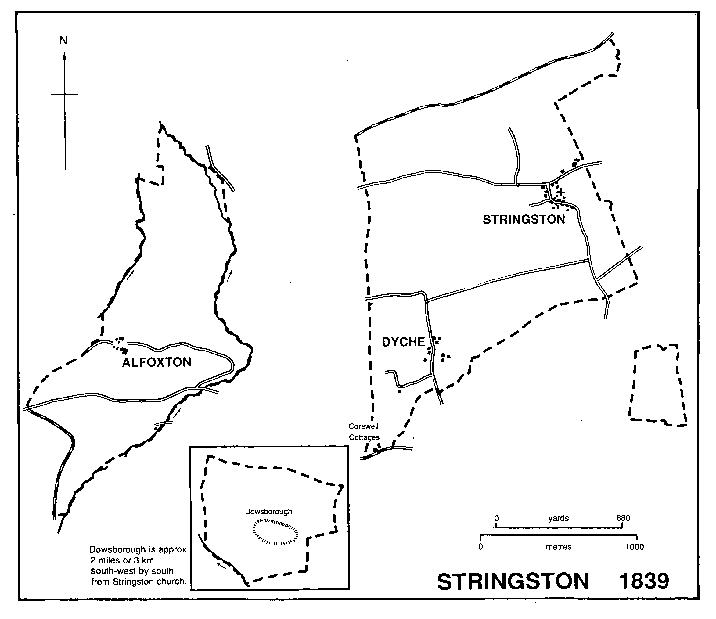
Stringston 1839
The main part of the parish lies on ground rising from Stringston village northwards to a slight ridge of just over 107 m. on its northern boundary at Harford Lane. The slope comprises bands of valley gravel, Lower Lias, limestone, and marls. (fn. 8) Limestone was quarried in that part of the parish by 1662 (fn. 9) and two quarries survived into the 19th century. There was a limekiln north of Prior's Farm and another in a marlpit further west. (fn. 10) Valley gravels predominate south and south-west of Stringston village, the land rising gently to 107 m. (fn. 11) Sand was dug on the edge of Stringston common, south of the village, by 1519 (fn. 12) and gravel at an unknown site by 1651. (fn. 13)
The Alfoxton part of the parish rises from just below the 46-m. contour at Putsham up the Quantock scarp to 244 m. on Longstone Hill, whose steep and wooded south-eastern slope, known as Willoughby Cleeve, forms one side of Hodder's Combe. The slope was known as Wildway Edge in 1681 (fn. 14) and as Willine Cleeve in 1839. (fn. 15) Hodder's Combe is named after Anthony Hodder, tenant of a house and land there by 1809 and in 1839. (fn. 16)
The Perry Mill part of the parish included fields called claypits, and was largely on marl. (fn. 17) Dowsborough, formerly common land and coppice (fn. 18) and in 1986 oak scrub, occupies a steep hill rising to 333 m., and is composed of Hangman Grits. (fn. 19)
Within the single bank and ditch of the probable Iron-Age hill fort at Dowsborough are two earthworks, one a ditched round barrow, the other possibly a saucer-barrow. (fn. 20) In the later 16th century the site was called Dolesbery or Dolebery, and in the 17th Deuxbarrow or Dewsbarow. (fn. 21) Late forms such as Danesborough have given rise to speculation about Danish invasions. (fn. 22) A late-Roman coin hoard is said to have been discovered above Alfoxton, (fn. 23) apparently near the Great Road which, until the later 18th century, was the main route westwards from Bridgwater to Watchet. (fn. 24)
Two roughly parallel east-west roads cross the main part of the parish, both from Stogursey; the southern road, leading to Holford and the Great Road, was called Portway Lane. (fn. 25) Two parallel north-south roads may also have existed, but only parts survive. Stringston village lies at the junction of the eastern and northern routes, and comprises the church, Stringston Farm, and a cluster of small houses around a now enclosed green. No. 1 Stringston and the Cottage are medieval in origin; nos. 5 and 9-11 (originally one house) are probably of the 16th century. Dyche lies on the eastern route whose junction with Portway Lane is a staggered crossroads. That crossroads was mentioned in the mid 12th century in association with land called 'Aladich' and with meadow 'on the lower way', (fn. 26) the way perhaps now represented by the footpath between Dyche and Corewell. Dyche Farm is an 18th-century building; an adjoining barn has one jointed-cruck truss. Corewell, a group of cottages, was mentioned in 1275-6 and there was a house at Gugglemoor, adjoining to the north, in 1317 and 1592. (fn. 27)
In the Alfoxton area of the parish are the former capital messuage, now the Alfoxton Park Hotel, reached from Holford by a long woodland drive, and Granfield's Tenement, a house on the edge of Hodder's Combe, mentioned in 1629. (fn. 28)
There were small areas of open-field arable at Dyche in the early 14th and the 17th century, at Shortridge, west of Stringston village below the road to Kilton, also in the 14th century, (fn. 29) and at the Raps, immediately north of Stringston village. Traces of strips remained in all three places in the 19th century, (fn. 30) but most arable was inclosed by the later 16th. (fn. 31) The field at Alfoxton, probably in open cultivation, was mentioned in 1242. (fn. 32)
There were commons at Stringston, Alfoxton, and on the Quantocks. Stringston Heathfield, south of Stringston village, was already being encroached upon by 1519, (fn. 33) but part of it still remained in 1751. In 1807 it was said that 13 a., probably the last to survive, had been recently inclosed. (fn. 34) Four acres of Alfoxton common, on Longstone Hill, 'measured out by an ancient measure called Quantock measure', were inclosed c. 1629; (fn. 35) there were probably further inclosures later in the 17th century, (fn. 36) and by 1839 just over 34 a., then known as Stringston common, had been absorbed in the Alfoxton estate. (fn. 37) In the mid 12th century a holding in the parish claimed housebote and haybote in the wood of Quantock. (fn. 38) Dowsborough, c. 1620 comprising some 80 a. of coppice and the remainder of 'clear down', was all subject to common rights for sheep pasture. (fn. 39) Dowsborough woods, 60 a. in extent, were let from 1717 to a Nether Stowey innholder for 99 years, (fn. 40) and by 1812 comprised stunted oak coppice on and within the ramparts, and 60 a. of hill pasturage outside. (fn. 41) By 1839 there were 167 a. of wood in the whole parish, including four copses north of Stringston village and woods near Alfoxton at Willoughby Cleeve and further north at Dog Pound, part of the Alfoxton estate. (fn. 42) Willoughby Cleeve and other land, acquired from the St. Albyns, was given to the National Trust by Mr. G. A. Falk in 1951, (fn. 43) and other woodland was bought by the League Against Cruel Sports in 1981. The Dog Pound, a small walled enclosure by the entrance to the drive to Alfoxton Park, was restored and presented to Holford village in memory of Mr. J. L. Brereton, the former owner of the Alfoxton estate, in 1982. (fn. 44)
Fields west of Stringston village, probably held with the capital messuage, seem by their names and shape to have formed a park. (fn. 45) A park at Alfoxton had been created by 1797 which, under the terms of the will of Lancelot St. Albyn (d. 1878), was to be stocked with at least 50 head of deer. (fn. 46) About 1900 there were 80 fallow deer in the park. (fn. 47)
A victualler in the parish was licensed in 1676 and there were two more in 1690. An innkeeper was in business between 1735 and 1756. (fn. 48) There was no inn by 1802. (fn. 49)
There were 14 households in the parish in 1563. (fn. 50) By 1801 the population was 121. It rose gradually to 159 in 1851 but fell rapidly to 114 in 1881. The population of the civil parish was 121 in 1891, but fluctuated to 92 in 1921. In 1931 it stood at 155. (fn. 51)
William and Dorothy Wordsworth occupied Alfoxton House between July 1797 and April 1798, and S. T. Coleridge and other members of their literary circle visited them there. (fn. 52)