A History of the County of Somerset: Volume 7, Bruton, Horethorne and Norton Ferris Hundreds. Originally published by Victoria County History, London, 1999.
This free content was digitised by double rekeying. All rights reserved.
A P Baggs, M C Siraut, 'Bruton', in A History of the County of Somerset: Volume 7, Bruton, Horethorne and Norton Ferris Hundreds, ed. C R J Currie, R W Dunning (London, 1999), British History Online https://www.british-history.ac.uk/vch/som/vol7/pp18-42 [accessed 30 April 2025].
A P Baggs, M C Siraut, 'Bruton', in A History of the County of Somerset: Volume 7, Bruton, Horethorne and Norton Ferris Hundreds. Edited by C R J Currie, R W Dunning (London, 1999), British History Online, accessed April 30, 2025, https://www.british-history.ac.uk/vch/som/vol7/pp18-42.
A P Baggs, M C Siraut. "Bruton". A History of the County of Somerset: Volume 7, Bruton, Horethorne and Norton Ferris Hundreds. Ed. C R J Currie, R W Dunning (London, 1999), British History Online. Web. 30 April 2025. https://www.british-history.ac.uk/vch/som/vol7/pp18-42.
In this section
BRUTON
The ancient parish of Bruton, (fn. 1) at the centre of the hundred of the same name, has interlocking boundaries with Pitcombe and Shepton Montague to the west and south (fn. 2) and dependent chapelries of Brewham to the east and Pitcombe to the west (fn. 3) indicating its probable origin as a pre-Conquest minster parish. At its centre is the former market (fn. 4) and later cloth- and silk-producing town (fn. 5) of Bruton, the site of a priory, later an abbey, of Augustinian canons. (fn. 6) The parish includes the hamlets of Wyke Champflower to the north-west and Redlynch to the south-east, and the former mansion and park of Redlynch.
The ancient parish measured 6 km. at its widest from east to west between Cogley wood and Wyke Champflower and 5.4 km. from north to south from the high ground above Whaddon House to Knowle bridge on the southern boundary of Redlynch park adjoining Shepton Montague parish. It was, however, irregular in shape: a tongue of Pitcombe intrudes into its western side for nearly 2 km., there was an island of the same parish around Discove Farm, and small areas of Shepton Montague also lay within Bruton. Some of those bounds were 'not precisely known' but were agreed in 1811, (fn. 7) although those parts of Bruton within Shepton were evidently ignored by the tithe surveyors in 1840. (fn. 8) In 1884 Discove Farm and its immediately surrounding fields were transferred to Bruton and in 1885 the area on the north-eastern side of the parish known as Eastrip or Sheephouse was similarly transferred. (fn. 9) In 1981 the area of the civil parish was 1,622 ha. (4,008 a.). (fn. 10)
Most of the parish lies in the area where Oxford Clay and Cornbrash limestone forming the western side of the Selwood ridge give way to irregular north-south bands of clay with Forest Marble or Fuller's Earth, followed further west by limestone, Midford and other sands and, on the western edge of Wyke Champflower, clay and undifferentiated terrace deposits. (fn. 11)
The topography and settlement are both heavily influenced by the river Brue which flows roughly south-west through the parish from the Selwood ridge and has formed for much of its course within the parish a steep-sided valley. Its name may derive from the Welsh, meaning brisk and vigorous, (fn. 12) and until the creation of a flood barrage to the north-east in 1984 the town was often flooded. (fn. 13) The river within the town has at least once changed its course. (fn. 14) On the northwestern side of the river the land rises to over 160 m. east of Whaddon House and to roughly the same height on Chorley or Charldon Hill to the north-west of the town. Between those two points flows the Coombe brook, rising in Brewham parish and forming part of the boundary between Bruton and Milton Clevedon. Trendle Hill, west of Chorley Hill, overlooks Wyke Champflower and the broadening valley where the Brue meanders through flat pastures.
On the south-eastern side of the river the valley side is less steep, but the land eventually reaches 138 m. between the town and Cogley wood on the eastern parish boundary and over 160 m. further south-east at Redlynch. Two smaller hills nearer the town appear more prominent, the one topped by the so-called abbey dovecot and the other to the west behind Lusty. South of those two hills lies a plateau largely in Pitcombe parish, beyond which is the western part of Redlynch park, a tract of ground which slopes down to the Bruton boundary at the Shepton brook.
The principal medieval routes through the parish seem to have been based on two river crossings, one south-west of the town, the other linking the priory (later abbey) with the town centre. (fn. 15) The second was a route from Dorset which passed close to the west of Selwood forest. In the later 17th century that second road formed part of the route between London and Barnstaple via Warminster and Maiden Bradley. (fn. 16) It was also said to be part of the high road between Weymouth and Bristol. (fn. 17) Under an Act of 1756 the Bruton turnpike trust adopted the road from Castle Cary through Pitcombe and two other routes, all three of which passed through the centre of the town and turned north up Coombe Street towards Milton Clevedon, Batcombe, and Frome; and one route south to Stoney Stoke in Shepton Montague parish. A cross route avoiding the town linked the Hardway in Brewham with Shepton Montague via Redlynch. That route was realigned in 1750 when Redlynch park reached its greatest extent. (fn. 18) In 1790 a branch road from Hardway in South Brewham to Dropping Lane in Bruton was officially stopped up, (fn. 19) although it appeared still to be open in 1800. (fn. 20) In 1793 the road to Wyke from the town was adopted (until 1867) and also Quaperlake Street eastwards to the Burrowfield tollhouse, to join the turnpike from Maiden Bradley. In 1810 the road north of Burrowfield became part of a new route to Frome. The Bruton trust was dissolved in 1876. (fn. 21) In the later 18th century the town was at the crossing points of routes between Frome or Warminster and Yeovil, Sherborne, and Crewkerne, and between Poole and Bristol or Bath. (fn. 22) Improvements after 1810 provided two different routes to London. (fn. 23) In the later 19th and the 20th century the principal route through the town has been that between Yeovil and Frome. Among the minor routes in the parish was one which divided at Discove Farm. The eastern branch, known as Broad Down Lane, emerged a few yards west of the present Redlynch chapel. It was still open in 1817 but not by 1885. (fn. 24) The western branch seems to have been part of a route from Shepton Montague to Bruton and was later known as Discove Lane. (fn. 25) It was diverted at its southern end because of the extension of Redlynch park c. 1745, but was still open for its entire length in 1817. The southern part was closed before 1885. (fn. 26)
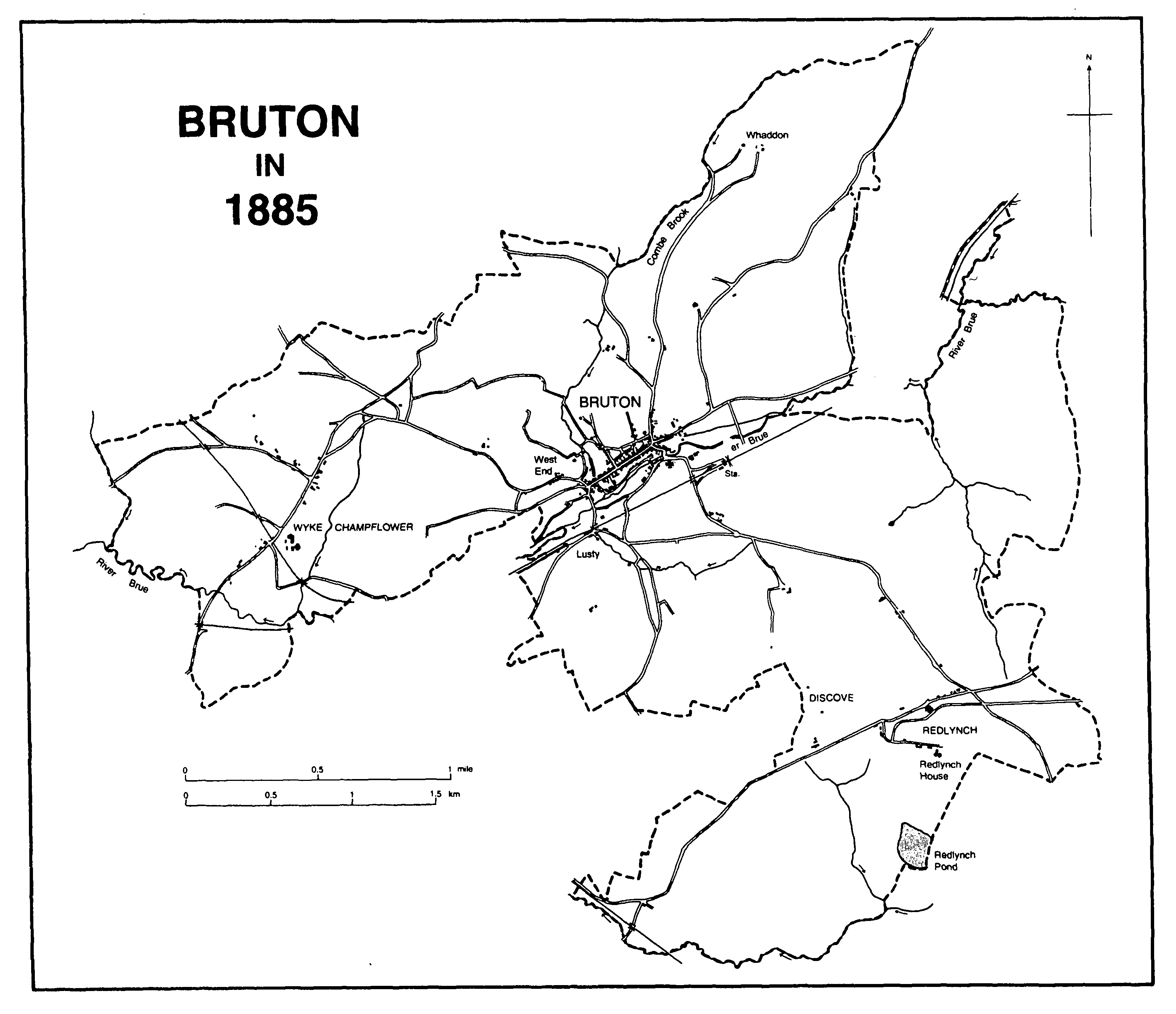
Bruton in 1885
Bruton railway station is on the line opened in 1856 between Frome and Yeovil by the Wiltshire, Somerset, and Weymouth Railway. (fn. 27) From 1906 it was also linked directly to Taunton and Exeter and in 1995 was on the main line between London and Plymouth. (fn. 28) Part of the track of the Somerset Central Railway, later Somerset and Dorset Railway, opened in 1862 runs through Wyke Champflower. (fn. 29)
In the mid 18th century there were three principal bridges in the town. (fn. 30) Church bridge, of three arches, crossed the river north-west of the church and earlier in the century was decribed as having at least two tenements and three houses on it. (fn. 31) It was said to be wide enough for carriages 'only in necessity' (fn. 32) and still had two houses on it in 1819. (fn. 33) The bridge was repaired in 1762-3 at a high cost, and again in 1985. (fn. 34) A second three-arched bridge, at the west end of the town, was called Legs or Leggs bridge by the early 18th century. It was rebuilt in 1930. (fn. 35) A third, narrow stone bridge, of a single arch, links Plox with the back ways below High Street. It was known as Bow bridge by 1707. It was rebuilt after flood damage in 1982. (fn. 36) In the 1770s there were four private footbridges across the Brue. (fn. 37) A single arched bridge crossing the Wincanton road near Durslade Farm was known as Park bridge and linked the park with other land. It had been built by 1856 and was demolished c. 1930. (fn. 38) Wyke Champflower bridge was a county bridge in 1677. It has two pointed arches and a central cutwater, and was declared dangerous in 1854. (fn. 39) Other bridges in the town or parish include Swill's bridge, built in 1770, and another carrying what was called the Old Law Way, built in 1777. In 1783 the building of a new bridge involved the destruction of a house in Silver Street. (fn. 40)
A possible barrow has been identified at Redlynch. (fn. 41) A Roman tesselated pavement was found at Discove in 1711 and elsewhere in the parish before 1714 a Roman pig of lead of the 2nd century A. D. The site of neither find has been established. (fn. 42) A road to Discove from Creech Hill in Lamyatt has been postulated. (fn. 43) A Saxon sword was found in 1984 on Sheephouse farm in the east of the parish. (fn. 44)
The Saxon origin of the town probably derives from the religious foundation south of the river. (fn. 45) By the earlier 16th century there were two principal streets north of the river, one running from north to south and another, 'far fairer', from east to west. (fn. 46) The first, known as Coombe and Patwell streets by the 17th century, (fn. 47) ran steeply down to the bridge below the parish church, forming a market place where it crossed the other thoroughfare. Quaperlake, High, and West streets, running from east to west and ending at West End, followed a ledge above the flood level of the Brue. Sonday and Cart lanes ran up the slope above High Street by the early 16th century to a small plateau named Tolbury, (fn. 48) probably earlier the site of a farm and hence the name Old Barton. (fn. 49) Other lanes, known as bartons, ran south from the principal street to the Brue. South of the river a street, known as Gye Street by 1406, Silver Street by 1654, and later as Plox, (fn. 50) ran beside the priory enclosure from the parish church westwards. The western extension of the street, south-west of the town, was known by the late 14th century as Lusty or Lysty. (fn. 51)
Buildings in the town centre, notably in High and Patwell streets, are superficially of the 17th, 18th, or earlier 19th centuries, a few with original shop fronts. Several, however, in High Street, including nos. 16-20 and 34-6 are of timber construction of the mid 15th century, and others behind the main ranges, including one in Amors Barton, date from the earlier 15th century. Most of the houses in Quaperlake Street date from the 18th and 19th centuries while West End was largely the product of the town's industrial expansion in the earlier 19th century.
Several detached houses were erected just beyond the limits of the built-up area from the earlier 18th century including Tolbury House, Berkeley House, and West End and Combe villas; and others further to the south-west including no. 17 and Cliff House along the road to Cole in Pitcombe, (fn. 52) Whaddon House, in the north-east, probably by 1739, (fn. 53) and Marksdanes, by the Frome road, (fn. 54) the last having a garden designed by Gertrude Jekyll. (fn. 55) Building in the 20th century has been principally to the east and the south-west.
Wyke, Discove, and Redlynch were settlements on discrete estates in the 11th century and Bickwick occurs in the 14th century. (fn. 56) Wyke had its own chapel in the 12th century, (fn. 57) and settlement is around farmsteads beside two roads, both of which had traces of greens in the 19th century. (fn. 58) Discove was part of Redlynch chapelry (fn. 59) and lay beside a lane running south from Discove Farm and along the Pitcombe boundary to the Redlynch-Shepton Montague road. (fn. 60) By 1885 the southern part of the lane had been reduced to a footpath and the hamlet comprised Discove Farm in the north, Discove House in the south, and a few cottages between. (fn. 61) There were no cottages occupied by the 1950s. (fn. 62)
Redlynch hamlet in the earlier 18th century comprised eight houses along a single street west of Redlynch House and four beside a road to the north. (fn. 63) That road was realigned when Redlynch mansion and grounds were rebuilt and extended (fn. 64) and houses were built on its north side.
Bickwick, in the south-west corner of the parish near the boundary with Shepton Montague and occasionally described as a manor, (fn. 65) contained four taxpayers in 1327. (fn. 66) In 1660 the hamlet contained a large number of paupers, (fn. 67) but by 1689 apparently only four tenements. (fn. 68) The settlement seems to have been abandoned in the earlier 18th century, (fn. 69) probably because of the extension of Redlynch park. (fn. 70) It may have been replaced by cottages and the Chequers inn further west.
Land use
There were two open arable fields north and south of the town, (fn. 71) two east and north of Wyke Champflower, (fn. 72) two north and south of Discove, (fn. 73) and probably two at Redlynch. (fn. 74) Landshares were mentioned at Wyke in the early 17th century (fn. 75) and several of the fields were renamed as open arable shrank in the 18th century because of inclosure. (fn. 76) There was an area of common pasture at Redlynch, south-west of the mansion, which became part of Redlynch park in the mid 18th century. (fn. 77)
In the 11th century there was extensive woodland on the eastern side of the parish and the area remains well wooded. (fn. 78) A park was created, evidently by the canons, south of the abbey, probably in the earlier 16th century, and at Redlynch in the mid 18th. (fn. 79)
Inns and taverns
In 1327 a taverner was in business in the town (fn. 80) and in 1555 a man was licensed to keep a tavern there for 10 years. (fn. 81) There were two named inns in the later 16th century, the George and the Hart, (fn. 82) and c. 1621 there were 6 innholders and 9 victuallers. (fn. 83) Among the signs in the 17th century were those of the Unicorn, the Green Dragon, the George, the Swan, the Three Goats' Heads, the White Hart, the King's Arms, and the Bull's Head. (fn. 84) In 1686 there were beds for 72 guests and stabling for 142 horses. (fn. 85) Early in the 18th century there were at least 14 inns of which 5, the White Hart, the George, the King's Arms, the Unicorn, and the Swan, were in the centre of the town and paid extra rent to the manor for penthouses. (fn. 86) In 1759-60 13 inns were rated, 10 of them in High Street. (fn. 87) In the 1780s there were 12 inns, of which 2 kept post chaises. (fn. 88) By 1792 the number of inns had been reduced to 5, the Blue Ball, the Sun, the Bell, the Old Bull, and the King's Arms, the last renamed the Wellington in 1813. (fn. 89) By 1840 the number had increased to 9 (fn. 90) but only 2 were described as comfortable. (fn. 91) By 1881 there were 10 inns. (fn. 92) In 1995 there were four.
Outside Bruton there was an inn named the Three Butchers on Redlynch common in 1738; the Bear, later the Dropping Lane inn, by the 1730s until 1800; the Chequers, beside the road north of Shepton bridge, by 1750 until 1857 or later; and the Cock, renamed the Fox, at Redlynch by 1789 which in the following year had stabling for 16 horses and was still in business in 1803. (fn. 93)
Social and cultural activities
A fight with the people of Batcombe in 1643 was commemorated by bell ringing each year on the eve of St. Matthias' day until 1733. (fn. 94) In 1746 a 'mock bull' from the town provided Christmas entertainment at Redlynch House, and Bruton 'choiristers' and mummers went there in the 1780s. (fn. 95) In the 1770s and 1780s a feast or revel was held in September with horse races at Burrowfield in 1795. (fn. 96)
In 1760-1 three friendly societies were founded in the town, one based at the Sun inn and another at the Bell, both later named after their places of meeting, and the third known as the Bruton Friendly society. The latter apparently had a membership of 101 in 1779. (fn. 97) The society at the Bell, known as the Old Bell, seems to have divided c. 1830, one part meeting at the Blue Ball. That part, re-founded c. 1855, was still in being in 1874. The Bruton Friendly met at the Sun from 1794 and a new society, the Bruton Union, at the Bell from 1808. The Bruton Society of Tradesmen met at the Wellington from 1815 and may have become the Waterloo Friendly. (fn. 98) One single society, known as the Old Bull Friendly society and meeting at the Old Bull, survived in 1914. (fn. 99)
Population
In 1563 there were 207 households in the parish including 10 in Redlynch. (fn. 100) In 1650 there were said to be 200 families at Bruton, 22 at Wyke, and 30 at Redlynch. (fn. 101) In 1737 a total population of 1928 was recorded but the figure was not considered reliable. (fn. 102) In the 1780s there were said to be 320 houses in Bruton, 12 in Discove, 16 in Wyke, and 8 in Redlynch. (fn. 103) In 1801 the total population was 1,631 and rose in the next three decades to 2,223. It remained over 2,000 until after 1861, but in the last year the figure was inflated by railway workers. By 1891 it had fallen to 1,776, (fn. 104) in 1911 to 1,755, in 1921 to 1,724, and in 1931 to 1,553. By 1971 the total had risen to 1,965, but in the next decade fell to 1,905. By 1991 new building at the east and south-west ends of the town had increased the total to 2,586. (fn. 105)
The town as a county centre
The assizes were held in the town once a year from 1268 until 1414 or later. (fn. 106) In the 15th and the 16th centuries several government commissions of enquiry met there, (fn. 107) and musters, Crown rent audits, and episcopal visitations took place. (fn. 108) Quarter sessions met there in 1603 (fn. 109) and intermittently between 1740 and 1786, (fn. 110) and inquiries for the Court of Wards were made there between 1601 and 1640. (fn. 111) The Crown rent audit continued to be held there in the later 17th century. (fn. 112) In 1623 the heralds met at the Unicorn to examine claims from people in five surrounding hundreds. (fn. 113)
The town in national affairs
Edward I was at Bruton in April 1278. (fn. 114) In 1471 men from Queen Margaret's army rode to the town as much for political propaganda as for recruitment. (fn. 115) Charles I heard a sermon in the parish church in 1625. (fn. 116) In 1640 the militia assembled there to march against the Scots, but were disbanded for lack of adequate pay. (fn. 117) In 1643 one of the Berkeley family, involved in a royalist plot to seize the town and Ilchester, raised a force to fight the puritan sympathisers of Batcombe. Sir Charles Berkeley was imprisoned and ordered to tell his tenants at Bruton not to bear arms against the parliament. In the following year Charles I and the Prince of Wales came from Mells to stay with Sir Charles. Goring's troops were nearby in 1645 and clubmen in the following year. (fn. 118) Sir Charles Berkeley, Edward Cheeke, Thomas Jervis, and others suffered sequestration for their royalist activities. (fn. 119) A riot in 1647 was caused by the presence of excise commissioners. (fn. 120) Col. Richard Bovett brought his regiment to the town in 1660 in face of a possible insurrection in Wiltshire. (fn. 121) Bishop Peter Mews held a visitation there in 1673, and preached in 1679. (fn. 122) Col. (Sir) Theophilus Oglethorpe led part of the royal army into the town in June 1685 before the battle of Sedgemoor. (fn. 123) Four men from the parish were accused of complicity in Monmouth's rebellion but all escaped arrest. One rebel was hanged in the town. (fn. 124) James II, who as duke of York had visited in 1665, (fn. 125) dined there in 1686 and Bishop Thomas Ken preached in the church twice in 1687. (fn. 126) William of Orange and Prince George of Denmark were there in November 1688 and troops were recruited for their cause. (fn. 127) Troops remained in the town in 1689 and were present again in 1691-2, 1715-16, and 1730. (fn. 128)
Among distinguished natives of the parish were Stephen Batman (d. 1584), author, translator, and domestic chaplain to Archbishop Parker; Rawlins Dring (fl. 1688), fellow of Wadham college, Oxford, and physician at Sherborne (Dors.); and Richard Michell, first principal of Hertford college, Oxford. (fn. 129) Charles Berkeley (cr. Baron Berkeley of Rathdowne and Viscount Fitzhardinge 1663, d. 1665) was a prominent royalist during the Civil War, lord of Bruton, and occupier of Bruton Abbey. (fn. 130) Sir Stephen Fox (1627-1716), statesman and founder of Chelsea Hospital, purchased Redlynch in 1672. (fn. 131)
MANORS
In 1066 four estates were recorded in what later probably formed Bruton parish. The land held by King Edward and called BRUTON was by far the largest, and included a settlement with burgesses. (fn. 132) A second estate with the same name was held in 1066 by Godwin and in 1086 by Erneis of Roger de Courcelles. (fn. 133) The subsequent descent of the second estate has not been discovered with certainty, (fn. 134) but in 1086 the main holding was still in the hands of the Crown although small parts, two of them evidently detached, were joined with other estates, namely Redlynch, Kilmington (Wilts.), and Charlton Musgrove. (fn. 135)
Grants made to Bruton priory by William de Mohun (II) (cr. earl of Somerset 1141) suggest that the royal estate had probably been dispersed by Henry I. (fn. 136) The Mohuns' tenure was short lived, for after further grants to the priory by William de Mohun (III) (d. 1176) the family and their successors the Luttrells remained only nominal lords and patrons of the priory. (fn. 137)
A second grantee of part of the royal estate was a member of the Tancarville family, before 1133 hereditary chamberlains of England and Normandy. The grantee was perhaps either William de Tancarville (I) (d. 1129) or his son Rabel (d. 1140). (fn. 138) William de Tancarville (II) succeeded his father Rabel as lord of the fee in Bruton and was still alive in 1177. (fn. 139) His son Ralph evidently followed. (fn. 140)
The Tancarville fee included the hundred, the market, and land held by Alexander de Cauntelo, one of whose family served Robert FitzGerold, lord of Charlton Musgrove, (fn. 141) and other land held by Terry of Mesnil-Mauger, who seems to have come from the Tancarville barony in Normandy. (fn. 142) The main terre tenant holding under Alexander de Cauntelo was Henry de Careville. (fn. 143) He and his daughters Emme and Antigona made grants to the priory. (fn. 144)
Two other holders in the Tancarville fee before 1161 and grantors to the priory were Wandrille de Courcelles and his tenant Roger de Granton, (fn. 145) the former possibly successor to the holding of Roger de Courcelles in 1086. (fn. 146)
Most of the priory grants were made within twenty years of William de Mohun's gift of Bruton church in 1142, (fn. 147) creating a new estate which remained in the hands of the canons until the dissolution of their house in 1539. Most of that estate remained in Crown hands until 1541 when the site, demesne land, and rectory were granted in tail male on a reserved rent to (Sir) Maurice Berkeley. (fn. 148) In the following year the rent was granted to Berkeley and in 1546 the same estate, later known as the lordship or manor of BRUTON, together with the hundred, market, rectory, and lands in Brewham was sold to him. (fn. 149) The rent was again charged in 1550 but remitted again in 1551. (fn. 150) Sir Maurice died in 1581 and was followed in succession by his son (Sir) Henry (d. 1601), his grandson (Sir) Maurice (d. 1617), and by his great grandson (Sir) Charles, who succeeded his own second son as Viscount Fitzhardinge in 1665 and died in 1668. (fn. 151) Charles was followed by his sons Maurice (d. 1690) and John (d. 1712), successively Viscounts Fitzhardinge, the second of whom died without male issue. In 1698 the heavily mortgaged manor was sold after a suit in Chancery to Sir William Brownlow. (fn. 152) In 1717 it was bought back by William Berkeley (d. 1741), Baron Berkeley of Stratton, grandson of Maurice. The manor passed successively to his third son Charles (d. 1765) and his eldest son John, Baron Berkeley. At John's death in 1773 reversionary interests under the terms of William's will included quarter shares for his surviving daughters, in 1772 owned by Barbara (Berkeley), widow of John Trevanion, who subsequently sold to John Bettesworth, and by Stamp Brooksbank, purchaser of the share of Frances Berkeley. (fn. 153) The remaining half share was in the hands of Sophia, daughter of Charles Berkeley and wife of Sir John Wodehouse. (fn. 154) In 1776 Henry Hoare bought all three shares. (fn. 155)
The manor passed on Hoare's death in 1785 to his daughter Anne, wife of her cousin (Sir) Richard Hoare (cr. Bt. 1786, d. 1787), and subsequently to their son Sir Richard Colt Hoare, Bt. (d. 1838). The last was followed by his half brother Henry Hugh Hoare (d. 1841), and Henry Hugh by his eldest son Hugh Richard (d. 1857). Sir Henry Ainslie Hoare, nephew of the last, was succeeded in 1894 by his cousin Sir Henry Hugh Arthur Hoare, Bt. (d. 1947), lord of the manor in 1939. (fn. 156) Much of the land had been sold in the earlier 19th century.
William Gilbert, prior and later abbot of Bruton from 1495 to 1532, (fn. 157) is said to have spent much money 'in building, almost re-edifying it'. (fn. 158) In 1539, after the dissolution of the house, the refectory and a first-floor chamber called the Doctor's Chamber were mentioned. (fn. 159)
The mansion known as Bruton Abbey, evidently incorporating some of the former abbey buildings, was arranged around two courts on two, three, and four floors, the ground floor largely occupied by services. (fn. 160) Each elevation (fn. 161) appears to have been roughly symmetrical, but the east and south wings were not at right angles to each other, and thicker walls and irregular features in the east wing suggest the presence of an earlier structure, presumably part of the conventual buildings of the abbey.
The house may never have been inhabited by the Hoares and in 1786 it was decided to reduce it in size and dispose of the materials. (fn. 162) Most had been pulled down by 1789 and the rest was ready for disposal by the cartload. (fn. 163)
In the early 1760s the immediate grounds had been laid out with lawns, ponds, trees, and walks. (fn. 164) The site had been abandoned twenty years later. (fn. 165)
By 1545-6 a park of some 30 a. had been created, presumably by the canons, on their demesne lands immediately south of the abbey. (fn. 166) Pillow mounds have been identified on its western side. (fn. 167) By the early 18th century the park measured 60 a. and was surrounded by a stone wall, (fn. 168) but later in the century the deer were removed and like the mansion the park was abandoned. (fn. 169) The roofless, gabled building on the hill in the former park may have originated in the later 17th century as a prospect tower built by the Berkeleys. Short avenues of trees radiated from it east, south-east, and south and it commanded views both of the park and meadows and woodland to the east, where there were walks around ponds. (fn. 170) Nesting boxes, clearly incorporated later, have suggested its more usual identification as a dovecot. (fn. 171) An obelisk, said to commemorate a favourite horse, was still standing in the park in the 1940s. (fn. 172)
In 1066 Tofig the sheriff held DISCOVE and in 1086 it was held by Harding de Meriet. (fn. 173) Before 1166 Henry Lovel (d. 1194) had deprived Drew the Younger of his fee there, (fn. 174) and Henry was succeeded in possession of 2 hides there and in Bratton by Ralph Lovel (d. 1207). (fn. 175) Hugh Lovel (d. 1291), great-nephew of the last, held ½ fee at his death. (fn. 176)
William Montagu (d. 1217) also had a fee there (fn. 177) which descended in the Montagu family like Shepton Montague manor (fn. 178) until the death of William Montagu, earl of Salisbury, in 1397, and in 1415 it was held by his widow Elizabeth. (fn. 179)
Roger de Somery, William Montagu's tenant, gave his holding to Bruton priory before 1198, (fn. 180) and a further grant seems to have been made later by Robert de Somery. (fn. 181) Another estate, described as a manor, was held in the early 13th century by Walkelin de Bonham, who in 1227 was sharing common land there with William de Somery. (fn. 182) The two holdings may have merged. In 1318 John Pagnel seems to have been the priory's tenant. (fn. 183) The estate passed to the Crown at the dissolution of the abbey in 1539 and, described as a manor, it was granted in 1543 to Thomas and John Horner. (fn. 184) Horner presumably sold it to Leonard Bosgrove who died in 1558 holding it in chief. His heir was his son Nicholas, then a minor. (fn. 185) In 1571 Nicholas sold it to Philip Cottington (d. 1615), (fn. 186) whose son Maurice died in 1654. (fn. 187) Maurice was succeeded by his son Francis (d. 1665) and by his grandson, also Francis (d. 1666), one of whom was knighted. (fn. 188) The last, also heir to his great-uncle Francis Cottington, Baron Cottington (d. 1652), was succeeded by his brother Charles. (fn. 189) Charles died in 1697; thereafter leases were granted by his brother John until 1713 (fn. 190) or later while the heir, Charles's son Francis, was a minor. The younger Francis was created a baron by the Old Pretender in 1716 and died in 1728. (fn. 191) In 1749 Francis Cottington, son of the last, conveyed the manor to Charles Berkeley and the earl of Ilchester. It then comprised a capital messuage at Godminster (in Pitcombe) and a farm at Discove. (fn. 192) Lord Ilchester bought the Berkeley share of Discove farm in 1774. (fn. 193)
Discove House is a stone building of two storeys and attics with a thatched roof between coped gables. Its irregular fenestration is of eleven bays and it has a projecting porch. It probably dates from the 17th and 18th centuries but has earlier features.
In 1066 Alvric held REDLYNCH and in 1086 it was held of the count of Mortain by Bretel de St. Clair. (fn. 194) By 1166 it was part of the Castle Cary barony of Henry Lovel (d. 1194), (fn. 195) and Henry was succeeded by Ralph Lovel who died in 1207. (fn. 196) Robert Lovel, Roger Lovel, and Roger's son Roger seem to have been successors to Ralph Lovel before 1242, the elder Roger evidently grandson of Robert. (fn. 197) The younger Roger was probably succeeded by his two sons Robert and Richard. (fn. 198) Hugh Lovel (d. 1291), of the main branch of the family, seems to have regained possession c. 1280 (fn. 199) and in 1291 he held one fee and one fee Mortain there. (fn. 200) In the later 17th century the lord of Castle Cary claimed that the owners of Redlynch owed him a red rose. (fn. 201)
Eustace of Redlynch held a fee under Henry Lovel in 1166. (fn. 202) In or before 1189 he had been succeeded by Robert of Draycott, whose son (Sir) William had followed by 1218. (fn. 203) William's son Richard held the estate by 1242, (fn. 204) Robert of Draycott in 1284-5, (fn. 205) and his heir, probably his son John, in 1291. (fn. 206) Another John held in 1346 and was alive in 1351. He was followed by his son Simon, and Simon by his only daughter Eleanor, wife of James FitzJames (d. c. 1391). (fn. 207)
James FitzJames, son of James, was dead by 1423 and was followed by his son John (d. 1476) and by his grandson, also John FitzJames (d. 1510). Sir John (d. c. 1542), son of the last and Chief Justice of the King's Bench, was succeeded by his cousin (Sir) Nicholas (d. 1550), although an interest in the manor was given for her life to Sir John's daughter Elizabeth. (fn. 208) Sir James, son of Sir Nicholas, died childless in 1579 and the estate passed to his brother Richard (d. 1595). In 1617 John, son of Richard, and his own son, also John, sold the manor or lordship and other estates to Sir Robert Gorges (d. 1648) of Bristol, a son of Sir Thomas Gorges of Longford (Wilts.). (fn. 209)
Thomas, son of Sir Robert, was followed by his only son Pointz (fn. 210) who died c. 1658 while still a minor. By will dated 1656 he devised Redlynch to his mother Margaret. She, who by 1652 (fn. 211) had married Richard Hastings (cr. Bt. 1667, d. 1668), was sole occupier by 1659 and until 1668. (fn. 212) Her ownership was challenged in 1659 on behalf of one member of the Gorges family, (fn. 213) and soon afterwards by Robert Phelips on behalf of his wife Agneta who was another. A settlement in 1662 awarded Margaret a life interest although Robert occupied the house from 1669. (fn. 214) In 1669 Margaret married Samuel Gorges (d. 1686) of Wraxall. (fn. 215) In 1672 Sir Stephen Fox bought the manor with Bickwick and half Stoke Holloway manor, Phelips's share, in repayment of a debt. (fn. 216)
Sir Stephen died in 1716 and was succeeded by his eldest surviving son, also Stephen, who took the additional name Strangways on his marriage in 1735. He was created Lord Ilchester and Baron Strangways in 1741, Lord Ilchester and Stavordale and Baron of Redlynch in 1747, and earl of Ilchester in 1756. (fn. 217) The first earl died in 1776 and the manor descended to successive earls of Ilchester: to Henry Thomas (d. 1802), to his son Henry Stephen (d. 1858), to William Thomas Horner (d. 1865), half brother of the last, to his nephew Henry Edward (d. 1905), and to Henry's son Giles Stephen Holland FoxStrangways. In 1912 the earl sold the Redlynch estate to the Cavendish Land Co. Ltd., (fn. 218) from whom it passed to Harman Bros., who sold in 1913 to W. F. Pepper. (fn. 219) By 1931 the estate had passed to Col. C. D. Learoyd-Cockburn, and from 1935 until her death in 1967 it was owned by Margaret (née Leiter), dowager countess of Suffolk and Berkshire. (fn. 220) From c. 1971 until c. 1982 it was occupied by a school, (fn. 221) and subsequently house and stable block were occupied as separate apartments, known respectively as Redlynch Park and the Clockhouse.
Sir John FitzJames (d. c. 1542) had a house at Redlynch in 1538 which included a great chamber over a parlour. (fn. 222) In 1579 it included a gilt chamber, Lady Berkeley's chamber, the Stourton chamber, a chamber over a buttery, and an outer tower chamber. (fn. 223) In 1681 that same house was described as large, serviced with lead pipes, roofed with stone tiles, and surrounded by 8 a. of courts, gardens, yards, and orchards. (fn. 224) Among its rooms were a hall, parlour, oriel, and kitchen with chambers above, one named after the marchioness of Northampton who had lived there seven principal rooms on the ground floor including a large hall with moulded panelling and plaster architraves, a domed staircase hall, and a drawing room with a richly decorated and gilded ceiling. Above were fourteen bedrooms. (fn. 225)
To the north-west of the house were low ranges of service buildings (fn. 226) which were reuntil her death in 1638, and another called Castle of Sparrows. (fn. 227) Extensive repairs were done in 1688. (fn. 228)
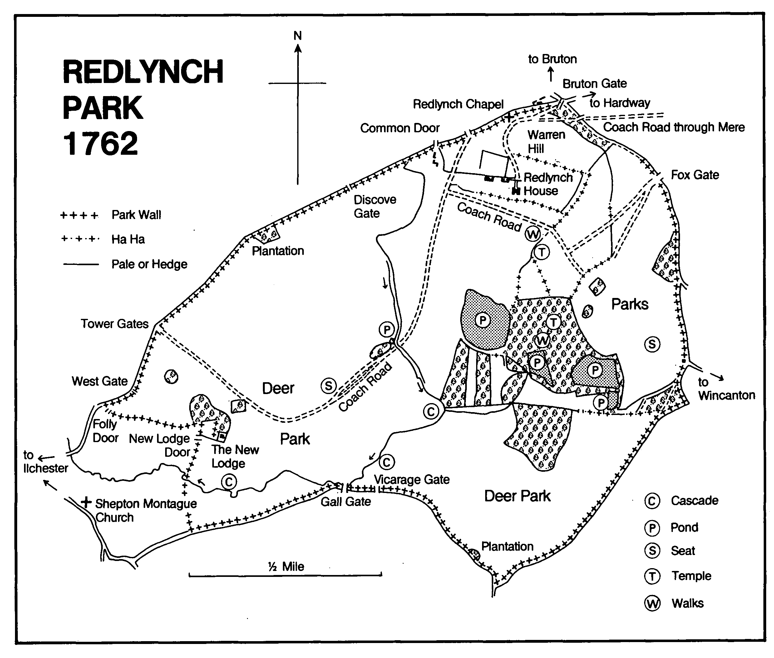
Redlynch Park 1762
About 1708-9 a new freestone house was built on an adjoining site, evidently to the designs of Thomas Fort, who was paid £1,444 17s. including money for a model. (fn. 229) The house had a west front of nine bays, the central three being beneath an enriched pediment. The south front had a recessed centre between short two-bayed wings. There were placed in the mid 18th century by two large blocks in line slightly further south. The first, eleven bays by six with an open court at the back, comprised service accommodation for the house, to which it was linked by a corridor. The second, of similar size and plan, was the stables. Presumably both were by Nathaniel Ireson who by 1729 and until 1755 or later was regularly employed, at first as a bricklayer but more usually as supervisor and probably designer of building works. (fn. 230) Work on the house continued into the 1750s involving a new drawing room and interior designs by Henry Flitcroft. (fn. 231)
By the 1830s the mansion had been partly abandoned but in 1851 it was occupied as a farmhouse. (fn. 232) The service block became the principal house in 1901 following its conversion by (Sir) Edwin Lutyens (fn. 233) and the corridor to the old house was removed. The converted former service block was seriously damaged by fire started by suffragettes early in 1914 and the old mansion was soon afterwards demolished. (fn. 234) The house was repaired, when the bay windows appear to have been added on the east, and between 1970 and 1985 the house and stables were converted into flats and maisonettes surrounded by communal gardens of 22 a.
In the earlier 18th century the house was approached from the west along a drive which was an extension of Redlynch village street. An avenue running south from the house into the valley and another north across the warren (fn. 235) seem to have been a projected early stage in creating a park, a plan developed more fully in 1738 by E. Grant, who proposed an area of c. 320 a. with the house in its northern part. The new approach was from the north-east through an avenue passing a bowling green and leading also to a terraced walk north-east of the house and to a serpentine walk in a grove to the south-east. The rising ground to the north of the house was depicted with a copse, shrubberies, an open grassed slope with paths leading to the former warren and to the re-sited Redlynch chapel beyond another shelter belt. Walled gardens were linked through a series of triangular stewponds. The proposed park included a rectangular lake in the valley bottom, replacing a natural pond, with groves and stock ponds beside it intersected by walks. To the west a pale was to form the boundary of a 200-a. deer park. (fn. 236) The whole area stretched into Shepton Montague parish to include former deer parks. (fn. 237)
Work had certainly started by 1729 and for twelve years brickmakers and bricklayers were almost continuously employed, at least in part on garden walls. (fn. 238) By 1732 a slope and a piece of water were said to have been finished and by 1734 Redlynch was said to have been 'extremely improved'. (fn. 239) The brick walls of the gardens were in 1994 retained in communal ownership, together with one of the stewponds, an orangery, and a summer house above a water house, the last of which seems to have been done up by Lutyens, who may also have been responsible for some of the terracing, steps, and gate piers.
Between 1740 and 1762 the park was increased to its maximum size of over 750 a. Planting began in 1740, the great pond was finished in 1741, and the whole was walled in 1748-50. The eastern approach to the house was linked with the private New Road, leading through Brewham parish to the Selwood ridge near Stourhead (Wilts.) begun in 1745. A new western entrance was through a gothic gatehouse with two embattled towers, built in 1755 to designs by Henry Flitcroft. Within the park were a Chinese seat, a Temple, and cascades. (fn. 240)
In the late 1790s the owners proposed to abandon the park to agriculture and by 1857 most of the ornamental part had become Redlynch Park farm. (fn. 241) Cascades, bridges, the great pond, and much of the woodland survived in 1994, together with a house, first projected as a lodge and later known as the Menagerie or the Aviaries, and c. 1790 as 'a family house and outbuildings suitable for rearing pheasants'. (fn. 242) It later became a farmhouse.
In 1166 William de Mohun (III) was lord of a fee 'of the new feoffment' created since 1135 and held by Luke de Champflower. (fn. 243) Lordship of what came to be WYKE CHAMPFLOWER manor descended in the Luttrell family with the honor of Dunster until 1626, when an unsuccessful counter claim was made by Sir Charles Berkeley in respect of Bruton manor. (fn. 244)
Luke de Champflower held an unnamed fee in 1166. (fn. 245) By 1196 and until 1202 or later the owner was John de Champflower, and by 1219 John had been succeeded by a second Luke, who was still alive in 1232. Henry de Champflower, probably son of the last, was under age in 1243 and still alive in 1256, and was followed by William de Champflower, owner by 1280, who died in or before 1289 leaving a son Henry under age. Henry de Champflower died between 1331 and 1346 when his widow Joan was in possession. (fn. 246) In 1349 John Champflower was lord of the manor, and two years later he granted Wyke to Thomas FitzJames, husband of Margaret who was evidently his heiress, in return for a rent for his life. (fn. 247)
Thomas was succeeded in turn by his two sons, John and James; James married the heiress of Redlynch and died c. 1391. Thereafter the manor descended like Redlynch to James FitzJames (d. 1579), who granted Wyke to his brother Richard (d. 1595) in 1569. (fn. 248) In 1608 John FitzJames sold the manor to Henry Southworth (d. 1625), (fn. 249) who was succeeded by his two daughters, Margaret, wife of Arthur Duck, and Jane (d. 1657), wife of William Bull. Bull's estate was sequestrated in 1646. (fn. 250) In 1668 he acquired the shares of Margaret's daughters and the whole manor descended on his death in 1676 to his son Henry (d. 1692). (fn. 251) Between 1711 and 1717 courts were held in the names of Henry's daughter Eleanor and of her husband George Dodington (d. 1720) after the death of Henry's son, also Henry, in 1695, but on Dodington's death, evidently after Eleanor's, the manor passed to Henry Bull who died in 1751. (fn. 252) Elizabeth (d. 1792), heiress of Henry and wife of Thomas Strangways, was succeeded by her son Henry Bull-Strangways (d. 1829), and his heir was his son Henry, who in 1840 put up the manor or reputed manor for sale. (fn. 253) No further reference to the manor has been found.
Wyke Champflower Manor is of stone rubble with ashlar dressings and slate roof and comprises a 15th-century range which may have included an open hall at its north end, and an addition of c. 1820 at right angles at its south end.
In 1539 John Drewe was granted the parsonages formerly of Bruton abbey, but almost immediately was dispossessed in favour of (Sir) Maurice Berkeley. (fn. 254) In 1541 Berkeley acquired a grant in tail male subject to a rent of what came to be known as the RECTORY of Bruton, defined as the patronage of the living, lands and tithes formerly belonging to the canons within the parish, the chapels of Brewham, Pitcombe, Redlynch, and Wyke, and tithes in Hadspen, Honeywick, and Brewham. (fn. 255) The estate was granted in fee simple in 1546. (fn. 256) Ownership descended like Bruton manor through the Berkeley family to Sir Richard Colt Hoare.
In 1254 Roger de Laleye and his wife granted to the prior of Stavordale a hide of land in Bruton. (fn. 257) By the later 14th century the land was scattered throughout the parish and was let in small parcels. (fn. 258) In 1533 the estate passed into the ownership of Taunton priory, but by that time much of it was let. (fn. 259) The Crown granted reversionary leases from 1552, but from 1580 the actual tenancy passed to Hugh Sexey. (fn. 260)
ECONOMIC HISTORY
Coins were minted at Bruton intermittently in the 10th and the early 11th century. (fn. 261) As a contributor in 1086 to the third penny and home of 17 burgesses and 28 bordars, it is generally considered to have been a borough or at least 'a small urban settlement in a rural setting'. Five of the burgesses were on the royal estate, but 11 belonged to Pitcombe and 1 to Castle Cary. The Crown estate at Bruton contributed equally with Frome to one night's firma. (fn. 262) No further evidence of a borough survives.
Agriculture
The agricultural estates in the later 11th century comprised the Crown holding which paid no geld but was reckoned at 50 ploughlands, the estate of Roger de Courcelles which gelded for 1¼ hide and was assessed at 2 ploughlands, Discove taxed for 1 hide and comprising 3 ploughlands, and Redlynch taxed for 4 hides and measuring 6 ploughlands. The Crown demesne was worked with 3 teams by 5 servi and 4 coliberts, but there was no demesne on the Courcelles holding. Discove had 2 demesne teams working 1½ virgate but with no recorded workers; Redlynch had 1 demesne team for 3 hides, again with no recorded workers. Twenty-eight villani and 26 bordars shared 18 teams on the Crown estate, a number which suggests several settlements. Three bordars shared 1 team on the Courcelles holding, 3 villani with ½ team worked the 2½ virgates at Discove, and 4 villani, 3 bordars, and 7 cottars at Redlynch worked 1 hide with 1 team.
In total 53 a. of meadow was recorded for the four estates, more than two thirds on the Crown estate, the rest at Redlynch. There was 150 a. of pasture on the Crown holding and 3 furlongs square at Discove. There were 20 sheep at Redlynch, 71 at Discove, and 80 on the Crown estate, goats (13) only on the Crown land, pigs at Discove (28) and Redlynch (20) and a riding horse each on the last two. Both the Crown estate and Redlynch had halved in value since 1066; the other two holdings had remained unchanged. (fn. 263)
Between the later 11th century and the later 12th the division of the Crown estate and the foundation and endowment of the priory radically changed the pattern of land ownership, though probably not its management. Large gifts by the priory's founder, William de Mohun (II), and by Alexander de Cauntelo, Henry de Careville (I), Wandrille de Courcelles, and Henry Lovel (d. 1194) were not usually described in topographical terms, but they evidently involved land in Discove and Redlynch as well as in and around Bruton. (fn. 264) Occasional smaller grants included one by a gate and one to enlarge a court. (fn. 265) Most grants were evidently in free alms; at least one was subject to a substantial rent. (fn. 266) In the first sixty years of the 13th century the priory acquired many small units of land either by direct grant or sale, (fn. 267) or as a consequence of the gradual dispersal of a holding. (fn. 268) At least two grants were subject to cash rent. (fn. 269) Further additions to the priory estate were made in the 14th century under mortmain licences adding small acreages both in and outside the parish, often for specified purposes such as the provision of lights. (fn. 270) By 1390-1 the priory demesne amounted to just over 310 a. (fn. 271)
The irregular terrain of the parish resulted in a fragmented pattern of cultivation where areas of arable were found on the less steep hillsides and on the southern plateau with pastures on steeper ground and meadows strung along the narrow valleys. At Combe in the 13th century one tenant gained access to his land through priory demesne pasture for carrying corn and hay and for driving cattle, while others used a dyke built by the canons to reach land cultivated every other year and for which they paid trusses of hay. (fn. 272) An agreement of 1227 concerned common pasture at Discove for oxen in meadows and for all sorts of cattle elsewhere, (fn. 273) and another of 1242 about common grazing at Redlynch for oxen on the moors, for cows, horses, and mares in the pastures, and for 100 sheep on the hills. (fn. 274) Occupational names in 1327 in Redlynch include a carter and a shepherd. (fn. 275) The scattered nature of holdings is illustrated in 1390-1 when priory demesne arable was apparently to be found in large fields, in grouped and discrete furlongs, and in closes. Field names such as New Close and Dykedmore record physical changes. (fn. 276)
Tenant holdings were also inevitably scattered. Typical was that of William Hooper in 1421 comprising 8 messuages, a mill, 26 a. of arable, 2 a. of meadow, 4 a. of pasture, and grazing for 2 cows and 20 ewes in Bruton, Discove, and Combe but also stretching south and west into Shepton Montague and Pitcombe. A larger holding acquired in 1410 by John Kyngeston included 156 a. of arable and 12 a. of woodland described as in Bruton, Redlynch, Godminster, Pitcombe, and Wincanton. (fn. 277) In contrast a holding at Wyke Champflower alone in the mid 14th century comprised 45 a. of arable, 5 a. of meadow, 3 a. of pasture, and common pasture for 6 oxen and 100 sheep. (fn. 278) Manumissions were recorded on Wyke Champflower manor in 1478 and 1483. (fn. 279)
By the earlier 16th century most of the abbey estate was let. In 1535 assessed rents amounted to nearly £95 from lands in Bruton, Brewham, and Pitcombe while the demesnes produced another £10 net and were administered by the bailiff of the hundred. (fn. 280) In 1539-40 Bruton manor produced over £68 from assessed rents from customary tenants of 116 holdings, and in addition there were similar holdings in Wyke, accounted with Pitcombe, and rents of free and customary tenants at Discove, Bickwick, and Holywaters totalled £10 7s. 6d. The site of the dissolved abbey and its demesnes were let to farm for £20 and the tithes of the parish accounted for nearly £32. (fn. 281) The former Stavordale priory estate was similarly let and produced nearly £8. (fn. 282) In 1545-6 the abbey demesnes comprised over 450 a. in closes and other land, both arable and pasture, in the common south field and were then, together with two areas of woodland, valued at £20 a year. Tithes of the rectory, from Brewham and Pitcombe as well as the ancient parish, were then valued at over £49. The whole estate in Bruton, Pitcombe, and Brewham was sold for £500 to (Sir) Maurice Berkeley. (fn. 283)
By the later 16th century farming at Wyke was predominantly pastoral. The principal farm in 1580 comprised 138 a. of meadow and pasture but only 40 a. of arable in the common fields. The grassland was largely by the river Brue, the names Wyke Marsh, Wyke Alders, and Summerleaze suggesting winter flooding. Some of the pasture on higher ground had formerly been arable. (fn. 284) By 1608 Wyke manor comprised 18 holdings of which the demesne farm was 180 a., the next in size 120 a., and others ranging between 81 a. and a cottage. (fn. 285) By 1621 eight farms were held by lease, the rest including one of c. 50 a. by copy. Two landshares held 'for turning the water' suggest the existence of water meadows. (fn. 286) In the 1650s exchanges recorded in the manor court indicate consolidation of holdings, (fn. 287) and references to piecemeal inclosure occur throughout the parish from the earlier 17th century. (fn. 288)
By the mid 17th century the former abbey estate held by the Berkeley family still stretched into Wyke, Pitcombe, and Milton Clevedon and comprised most of the town. Many tenant holdings had lands scattered in the common fields north and south of the town as well as urban properties. One of the largest tenants, Edward Moore the elder, held Combe farm on lease with 72 a. in closes, 100 a. of arable and pasture north of the farmhouse in Combe field, and over 33 a. dispersed in the common arable north field. He was also undertenant of a further 58 a. of pasture and coppice near Cogley wood. Rather more typical was the holding of another Edward Moore which comprised a house in High Street, 8 a. in strips in the north and south common fields, and common pasture for 20 sheep. Among the copyholdings was a farm which included former woodland at Ridgewood, pasture called Marks Deane, and 14 a. of land in the arable fields with common there for cattle and for 80 sheep. One farmer on the manor had arable strips in both Wyke field and Bruton north field. Most holdings on Bruton manor were subject to heriots, 58 paid a fat capon at Christmas, and 42 owed a harvest day work, normally commuted to 4d. (fn. 289) At a slightly earlier date one holding on the former Stavordale priory estate in Bruton was held in return for rent, a day's work or 6d., 24 new-laid eggs or 4d., to be paid at the lord's choice at St. James's tide, and suit of court. (fn. 290) In 1674 16 tenants on Redlynch manor paid 6d. or 1s. in respect of harvest days and a total of 52 eggs at Christmas. Payments for harvest days were also made by tenants at Bickwick. (fn. 291)
In 1674 the Redlynch estate comprised 529 a. of which 299 a. was let, two thirds among four farms, and 176 a. of demesne was let at rack rent for one year only. The pattern was superficially unchanged by 1685, but by that date general agricultural depression had brought the demesne farm and other lands in hand. Tenants both on that estate and on Lord FitzHardinge's were hard to find or seriously in arrear. (fn. 292) The Redlynch demesne farm, which had been improved in the 1670s with soap ashes, clover, and sainfoin, began the 1680s by supporting a dairy herd of over 60, a flock of 340 sheep, and a profitable business in fattening steers for Smithfield. Small acreages of barley, wheat, oats, beans, peas, and vetches covered only 44 a. for home consumption. (fn. 293) The sheep flock was reduced in size and finally removed to another farm on the Fox estate as agricultural depression deepened. (fn. 294)
A lease of 1648 permitted the tenant of a cottage the right to graze a ringed and yoked pig on the adjoining waste in return for both cash rent and the payment of 40 eggs at Christmas. Labour services in the form of harvest days were still occasionally recorded in the early 18th century but were always noted with a cash equivalent varying between 4d. and 5s. (fn. 295)
In the 1730s wheat, oats, barley, peas, and beans were grown widely in the parish, but the land was mostly under grass. Sheep were fed there, both born on the estate and bought in. The weekly Saturday market in the town was 'considerable'. (fn. 296) Redlynch farm, which included much of the park, formed an integral part of the Fox-Strangways estate by the late 1760s. In 1769-70 heifers were bought at Thames Ditton (Surr.) and at fairs at Hindon and Mere (Wilts.) to increase the dairy and wethers were purchased at Somerton fair. In the early 1770s a flock of over 200 sheep was regularly wintered in the park, spending the rest of the year at Kilmington (Wilts., then Som.), on the edge of Salisbury Plain. Permanent stock at Redlynch included some 40 head of cattle and 12 horses. (fn. 297) Purchases and exchanges around Discove in the 1770s allowed the possibility of creating consolidated tenant farms in an area where piecemeal inclosure was a continuing process. (fn. 298) Similar consolidated holdings emerged on the former abbey estate in addition to the 210-a. Combe farm, still held by lease by the Moore family in the early 18th century. (fn. 299) Gilcombe farm, a close of pasture with a new house at the beginning of the 18th century, had become a holding of 94 a. by c. 1786, possibly as a result of deliberate action by the Hoares. (fn. 300) Durslade farm was created from demesne land c. 1768 by the Berkeleys when new buildings were erected and perhaps as many as 320 a. was brought together. Included by the 1780s was the former park attached to the mansion. The Hoares reduced the holding to c. 286 a. (fn. 301)
From the 1780s game was exploited on the Fox-Strangways estate, potatoes were grown in the park, and the home dairy was let. (fn. 302) Much of the estate was said to be in need of draining, but orchards had recently been planted. The best land supported sheep and cattle well and grew turnips and barley. (fn. 303) In the late 1790s several attempts were made to sell the entire family holding and to divide the park into three farming units, but in the event the only change was to abandon Redlynch House and to let the home farm. (fn. 304) The Hoares had been more radical in the demolition of their mansion, (fn. 305) and sold some land, including Combe farm. (fn. 306) They retained and enlarged their two largest farms in the parish, Durslade (377 a.) and Gilcombe (227 a.). (fn. 307) At the opposite side of the parish, Wyke Champflower manor was offered for sale in 1840. It then comprised just over 400 a. of land devoted almost entirely to dairying. Wyke Manor farm covered just over half the estate, a second holding just over 100 a., and a third just over 44 a. The rest was in small lots including cider orchards. (fn. 308)
By 1857 the western part of the Fox-Strangways' Redlynch estate had been divided between two large and three smaller tenant farms. The largest, Redlynch Park farm, comprised 386 a. in Bruton and 223 a. in Shepton Montague, and was followed by Godminster farm with 504 a. mostly in Bruton and Pitcombe. A substantial holding including woodland remained in hand. (fn. 309) By 1912, when the estate was sold, the main part of the holding in the parish comprised Redlynch Park farm, woodland, and the mansion and its grounds which, combined with a farm in Stoney Stoke, amounted to 734 a. There were two other small farms, Dropping Lane (68 a.) and Redlynch (69 a.), and some woodland and pasture. (fn. 310) Elsewhere in the parish in 1881 Gilcombe farm was the largest holding, employing 11 men and boys; Combe and Whaddon, at 150 a., were half the size, and Lusty farm, whose land lay towards Pitcombe and Godminster, measured 246 a. At Wyke there were three holdings of over 150 a. (fn. 311) In 1905 there were 323 a. of arable and 4,014 a. of permanent grass. (fn. 312)
Woodland
Bruton included the largest single unit of woodland in the county at the time of the Domesday survey, part of the natural forest on the Selwood ridge. (fn. 313) One unit, on the royal estate, measured 5 leagues by 1 league, the other 2 furlongs by 1½ furlong. (fn. 314) The continued presence of woodland probably led to the notion still held in the 16th century that the bounds of Selwood forest included the eastern part of the town and the abbey site. (fn. 315) Woodland lay, indeed, in the north, east, and south-east parts of the parish. Ridgewood, mentioned in 1256, (fn. 316) covered the slopes above Combe brook and adjoined Milton Clevedon. Perhaps the last surviving part had been converted to arable and was part of the north field by 1661. (fn. 317) Moorwood, mentioned by name in 1390-1, lies on the edge of Redlynch park and extends into Shepton Montague parish under the name Stoke wood. It measured 30 a. in 1681 and in the following year grass in its laines was cut for hay. (fn. 318) In 1912 Moorwood and Stoke wood together measured 95 a. (fn. 319) Cogley wood, further north and also against the parish boundary, was part of the priory estate in the 13th century. (fn. 320) By 1656 some 12 a., described as wood or coppice, had been converted to grassland. (fn. 321) In the earlier 19th century Cogley wood measured 234 a. (fn. 322) Henley wood lay in the northeast part of the parish, between Whaddon and Gilcombe. It was part of the abbey estate at the Dissolution and of the Berkeley estate, and measured just over 52 a. in 1829. (fn. 323) It had been cleared by 1884. (fn. 324) Fairwood was part of Wyke manor and had probably been converted to arable by the later 16th century. (fn. 325) Hills wood, mentioned in 1768, was partly felled in 1787. In 1803 it measured 19 a., in 1805 and 1829 14 a. (fn. 326) By 1835 part had been planted with Spanish chestnut and oak. (fn. 327)
In 1790 the woodland on the Redlynch estate, containing ash, alder, oak, sallow, birch, and hazel, was regularly coppiced to satisfy demand for hurdles and faggots. (fn. 328) Similarly, woodland amounting to c. 300 a. was kept in hand by the Hoares and from the 1790s was exploited for timber, faggots, and bark. (fn. 329) The whole parish in the 1830s was said to be richly wooded, (fn. 330) and in 1905 there was 276 a. of woodland. (fn. 331)
Trade and industry
A fuller and a parchmenter at Bruton were mentioned in the late 12th century, a tailor was recorded in the earlier 13th, and by 1327 when a brewer, a taverner, 2 tailors, a weaver, 2 dyers, a mason, a helier, and a smith were working there, (fn. 332) it seems to have been a craft centre with an urban character. (fn. 333) In 1337 ale and bread were bought there for a household at Evercreech. (fn. 334) Among the businessmen in the 15th century were Henry Goldsmith, mentioned in 1418, (fn. 335) a spicer in 1429, (fn. 336) Thomas Smyth, who in 1443 was in debt to two London drapers, (fn. 337) and a chapman whose executors in 1452 owed money to a London grocer. (fn. 338) Among the more prosperous men in the later 15th and the earlier 16th century were a goldsmith, a fuller, two mercers, and four merchants, (fn. 339) and there were trade connexions of Bruton men with Abingdon (Berks.), Lyme Regis (Dors.), and possibly Beaulieu (Hants). (fn. 340) In the 1540s the parish was 'much occupied' with cloth making, (fn. 341) its products traded through Bristol by the clothier John Yerbury and the Bristol merchant John Smythe. Yerbury imported raw materials through Smythe including woad from the Azores for at least two fullers, wine for a vintner, and iron and oil for four smiths. (fn. 342)
Cloth production may have moved from the town in the later 16th century and prominent occupations seem to have been related to more general commerce. Two mercers were in business in the 1550s and another in the 1570s, (fn. 343) and a shearman in 1589-90. (fn. 344) Other occupations in the later 16th and the early 17th century included glaziers, scriveners, maltsters, tallow chandlers, and tailors. (fn. 345) Later in the 17th century craftsmen included a cutler in 1670 and Gabriel Felling, a goldsmith. (fn. 346) Two contemporary traders issued tokens. (fn. 347)
From the 1660s the production of serges and broadcloth was again recorded, (fn. 348) and leading townsmen who served as governors of the grammar school included clothiers and sergemakers. (fn. 349) Among the town's clothiers was the Quaker Thomas Whitehead, who at his death in 1691 had a stove house, dye house, cloth press, furnace, tools, cloth, wool, and yarn. (fn. 350) Outhouses at West End were leased 'for the clothing trade' in 1717 and the town was known for its so-called Spanish medleys. (fn. 351) Stockings were being produced by the 1690s (fn. 352) and in quantity in the 1740s, (fn. 353) and broadcloth, serges, and stockings were made a decade later. (fn. 354) By 1751 linen was also woven. (fn. 355) George Ward began silk throwing in 1769 in a mill evidently already owned by his uncle John Sharrer, but in 1772 he had to lay off workers and in the following year could only manage reduced output because of illegal imports of finished goods. (fn. 356) Serges and stockings were still being produced in the 1770s, (fn. 357) but by the late 1780s hosiery had declined. Silk reeling, however, was said to employ between 300 and 400 young people. (fn. 358) A silk house occupied by Thomas Sampson in 1785 and 1800 was in 1802 converted into a nonconformist chapel, (fn. 359) but in 1792 John Sharrer Ward leased a newly-built silk mill (fn. 360) and by 1816 he employed 1,000 workers, a third of them under 18 years of age, in two mills. Theophilus Perceval, established as a manufacturer at Pitcombe, also had a mill in the town. (fn. 361) In 1821 more than half the families in the parish were employed in trade or manufacture and while stockings were still said to be the principal product there were three silk mills. (fn. 362) In 1823 J. S. Ward employed up to 1,000 workers from the town and surrounding villages, some working in their own homes throwing Italian silk to feed 15,700 spindles. By 1829 the number of spindles at his factory in West End had been reduced to c. 7,000 and work was confined to four days a week. (fn. 363) The trade seems to have declined still further in the early 1830s. Knitting was said to be 'obsolete' and only enough hands were employed at silk throwing as to prevent the machinery being spoiled. (fn. 364)
The manufacture of hosiery and inferior woollen goods may for a time have revived, (fn. 365) but by 1841 J. S. Ward had two silk factories, one in Quaperlake Street, and J. and S. Saxon, formerly tenants of Theophilus Perceval, occupied one at West End. A second factory at West End was then empty. (fn. 366) The Quaperlake Street premises continued in use for throwing and winding silk until the early 1860s. By 1866 c. 100 people there prepared horsehair for seating. (fn. 367) The business continued until 1883 or later, (fn. 368) but in the early 1900s the premises were rebuilt as a bacon factory, which continued in business until the late 1950s. (fn. 369)
Professional people lived in the town from the mid 17th century including a succession of attorneys, physicians, surgeons, and apothecaries, (fn. 370) and at least two clockmakers. (fn. 371) By the 1790s a total of five waggons, presumably serving the silk and hosiery businesses, travelled from London on three days each week and among the shopkeepers was one specialising in toys. (fn. 372) In 1840 three waggon companies went to London a total of seven times each week, but coaches only went three days a week to Bath and Weymouth. (fn. 373)
By the mid 19th century an auctioneer, a bank manager, a surgeon, two solicitors, and a printer worked in the town and among the new businesses were two breweries and a brickyard. (fn. 374) By 1883 two timber merchants were trading, one operating a steam saw mill. (fn. 375) The Bruton Cooperative Society opened a shop in 1902, took over the bacon factory, had both a bakery and a creamery, and branches in Castle Cary, Evercreech, and Wincanton. The business in Bruton survived until the 1960s. (fn. 376)
Limestone was burnt in the parish in the 14th century (fn. 377) and at least five limekilns were in operation beside quarries in the 19th century. (fn. 378) There was a stone quarry on the east side of Dropping Lane in 1821. (fn. 379)
Market and fairs
There was a market in the earlier 12th century, granted to the canons of Bruton with the hundred by Alexander de Cauntelou. (fn. 380) The rent from the shambles in 1539-40 amounted to £4 4s. 8d. (fn. 381) In 1545 the market was granted by the Crown to (Sir) Maurice Berkeley and in 1565 was regranted to him, to be held on Wednesdays. (fn. 382) By the early 17th century the day had been changed to Saturdays. (fn. 383) About 1757 business was decribed as 'considerable' and commodities included corn, butchers' meat, garden fruits, butter, cheese, and sometimes fish. (fn. 384) By the 1780s business had declined (fn. 385) and in 1821 the market was said to be 'small'. (fn. 386) By 1836 it was said to have 'long been discontinued', (fn. 387) but in 1840 it was evidently still in existence (fn. 388) although in 1861 'of little importance'. (fn. 389)
A market cross was built at the junction of the three main streets by Abbot John Ely (1532-9). (fn. 390) It comprised a 'curiously carved' central shaft with six surrounding pillars holding a roof and supporting a stone balustrade with urns. The whole was on a stepped base with a room underneath. (fn. 391) The cross was demolished in 1787-8 when its site was repaired by the highway surveyors. (fn. 392)
A row of butchers' stalls or shambles ran west from the cross along High Street. There were 11 tenants when the shambles were first rated in 1697-8 and they grew in number to 33 in 1800. (fn. 393) Tithes were recorded on the surviving stalls in 1841 but they were not marked on the tithe map of 1843. (fn. 394)
In 1684 a market house was built by subscription on the north side of High Street. (fn. 395) The first floor was used for quarter sessions. (fn. 396) 'Some years' before 1861 it had been converted to dwellings. (fn. 397) The town hall near the market cross, erected by 1652, (fn. 398) was also used by 1768 partly as a market house and was still standing in the 1830s. (fn. 399) It, too, had been converted to dwellings 'some years' before 1861. (fn. 400)
In 1532 the abbot was granted licence for fairs on the eve, day, and morrow of St. George (22-4 April) and on the eve, day, and morrow of the Nativity of the Virgin (7-9 Sept.). The first was described as 'great' when held for the first time. The licence was extended in 1533 by charter to the abbey to include a court of piepowder and freedom of tolls and customs as enjoyed at Bartholomew Fair. (fn. 401) The fairs passed to (Sir) Maurice Berkeley in 1545. (fn. 402) In 1670-1 the hundred constables paid a man 'towards the procuring of the new fairs and markets gained to the town' (fn. 403) and the fair held on 29 May c. 1700 must have resulted. (fn. 404)
In the 18th century the fairs attracted dealers in horses, horned cattle, fat hogs, and later pedlary, (fn. 405) but by 1821 only the April and September fairs had survived, held on 21 April and 19 September. (fn. 406) Business declined during the 19th century and the September fair, held on the Sunday after the 19th, was known as the 'Bruton Veast'. (fn. 407) An annual cattle show was held in early December by 1835. (fn. 408) By 1883 it was called a cattle fair and was held on the second Thursday in October. By 1906 it had been amalgamated with sales in Castle Cary and Wincanton. (fn. 409)
In the early 17th century the fair was evidently held on a site known as the Plotts or Fair Place. (fn. 410)
By 1617 a fair was owned by the lord of Redlynch manor. (fn. 411) In 1669 it was said to be held on the eve and feast of St. Peter's day (31 July-1 Aug.) (fn. 412) and in 1681 on St. Stephen's day (2, 3, or 4 Aug.). (fn. 413) The fair was leased in 1705 with a cottage described as newly built on the fair place. (fn. 414) No further trace has been found.
Mills
In 1086 there were six mills on the royal manor and one on the estate of Roger de Courcelles. (fn. 415) One of those may be identified with a fulling mill at Combe described in the later 13th century as let to a tucker from Lullington and later to John le Gaunt of Bruton. (fn. 416) The mill, by 1512 owned by Stavordale priory, (fn. 417) passed to Taunton priory and in 1539 to the Crown, which sold it in 1554. (fn. 418) In 1576 it was owned by Sir James FitzJames but in 1581 it was still remembered as Staverdell's mill. In 1609 Hugh Sexey acquired the lease and in 1614 the freehold from John FitzJames. (fn. 419) It was later known as Poppet's or Pippet's and, subject to a rent to Sexey's Hospital, had passed to the Berkeley estate by 1637-8. (fn. 420) During the 18th century it was let as a fulling mill. (fn. 421) The mill was still in use in 1820 but had evidently been abandoned by 1841. (fn. 422)
A mill in which the families of FitzJames and Champflower had an interest in 1364 (fn. 423) may have been the mill at Wyke Champflower which by 1425 was held of the Luttrells by the FitzJames family. (fn. 424) Two mills there were let in 1576; in 1608, when described as a water grist or corn and malt mill, it passed with a farm of 120 a. as part of Wyke manor from the FitzJames family to Henry Southworth. (fn. 425) Ownership passed from Thomas Weston to John Cary in 1620, (fn. 426) and in 1697 it was let by Nicholas and Jane Smith. (fn. 427) It was apparently still in use in 1720 but not in 1746. (fn. 428)
There was a fulling mill on Bruton priory manor by 1355. (fn. 429) In 1410 Walter Smith held a mill which in that year passed from the Godmanston family to John Kingston. Another mill was settled in 1421 on William Hooper. (fn. 430)
In 1539-40 Stephen Broke held two mills of Bruton manor and William Hody one. (fn. 431) One mill on the manor was mentioned in 1608 (fn. 432) and another in 1597. (fn. 433) Either of those or the Town mill might have been that occupied by William Yerbury in 1626. (fn. 434)
In 1713 there were said to be five custom mills in Bruton manor. (fn. 435) One, known as Great mill and perhaps formerly Abbey mill, went out of use between 1768 and 1777. (fn. 436) A second was Little mill, named between 1690 and 1713. (fn. 437) A third, built by 1633, was off Quaperlake Street at the east end of the town, driven by the river Brue. It seems to have been known as Chessockes in 1664 when it was agreed that the tenant should have the use of the mud from the pond and should maintain the river banks. (fn. 438) The fourth mill may have been that known as Cuttern mill in 1669 and 1713, which went out of use before 1768. (fn. 439) The fifth was perhaps that known as Maundy's mill and described as in High Street, which seems to have closed between 1814 and 1819. (fn. 440)
By the later 1750s three of the five custom mills ground wheat and malt, one was a bunting mill producing fine flour, and one had been converted to grinding edge tools. (fn. 441) The last was the new mill at West End which was no longer a blade mill in 1768 but had a dyeing house adjoining and was probably soon converted to a silk mill. (fn. 442)
By 1819 there were two flour mills, one at West End and the other Pippett's, together with the former water mill at West End occupied by Ward's silk factory. (fn. 443) Town mill continued in business in 1906. (fn. 444)
By 1906 Backway Stores had been established by a corn, coal, salt, and seed merchant. (fn. 445) By 1939 the business incorporated milling equipment and was known as Tolbury mill. (fn. 446) It closed in 1989 (fn. 447) and was demolished in 1995.
LOCAL GOVERNMENT
In 1225 the townships of Bruton, Wyke, and Redlynch were each represented by a jury; a tithing of the township of West Bruton, mentioned then, may have been part of Bruton township or separate. The first three were regarded as tithings in 1284-5. (fn. 448) By 1316 Discove was a separate tithing and Wyke was joined in one tithing with Pitcombe and Cole. (fn. 449) That pattern of tithings continued into the 18th century, but by the 1780s Bruton was divided between east and west tithings, recalling the West Bruton tithing of 1225. (fn. 450)
No records of the manorial administration of the canons of Bruton have been found, but a manor court met every three weeks in the later 14th century, (fn. 451) a bailiff is referred to in the early 14th century, (fn. 452) a portreeve in 1385, (fn. 453) and a man was described in 1484 as steward of the monastery and bailiff of the town. (fn. 454) Perquisites from the court of the hundred and the manor amounted in 1535 to £7. (fn. 455) The abbey steward presided over a court of piepowder granted to the canons in 1533. (fn. 456)
The administration of Bruton manor seems to have been combined with that of the hundred under the canons if not earlier, and in the early 18th century the royalties of both together came from courts leet and view of frankpledge, goods and chattels, waifs and strays, and felons' and fugitives' goods, but not deodands. (fn. 457) Records of courts baron under the Berkeleys and the Hoares survive from 1691 and from 1750 comprise admissions and surrenders 1750-2 and 1759-63, presentments 1765, 1768-9, 1771, 1773, 1781, 1783-6, 1788, and 1791, and court books or extracts 1788-1821. (fn. 458) Sessions were held towards the end of each year at the Bell inn, with special courts held at other times in the George. Presentments were concerned largely with house repairs and nuisances, particularly unrepaired gates and fences. In 1799 there were complaints that embankments in the river had caused extensive flooding. A hayward was appointed each year.
In the 17th century the hundred bailiff and the two hundred constables were normally involved with parish officers in public affairs. (fn. 459) From 1813 a court leet seems to have been revived. It met annually in October or November and received presentments of a 'town jury of the hundred' concerning highways, footpaths, and nuisances within the town including bonfires and fireworks. The officers of the court were a constable, tithingmen for east and west tithing, and two affeerors. (fn. 460) The annual court leet continued to meet in the 1830s and to appoint a constable. (fn. 461)
No records of Redlynch courts have been found, but courts were held until 1717 or later. (fn. 462) Extracts of courts baron for Wyke record meetings, usually in spring or summer, between 1650 and 1721. (fn. 463) In the later 18th century one session was held at Wyke in the farmhouse adjoining the chapel. (fn. 464) In 1535 the canons' perquisites from a court at Discove amounted to 10s. (fn. 465)
Stavordale priory had a court which administered its estate in East and West Bruton. Court rolls survive for 1502 and 1512-13 (fn. 466) and sessions were held twice a year, with a homage jury concerned with renewal of leases and repairs to buildings. Later owners of the estate held courts for which records survive for 1610 and 1614- 15. (fn. 467)
By the mid 17th century the parish was administered by two churchwardens and two overseers of the poor, (fn. 468) actively supported by two constables for the hundred, one of whom operated exclusively within the town. (fn. 469) Annual accounts and rates were approved by ratepayers, sometimes known as paymasters, who varied in number between 2 and 28, usually fewer than 20 in the 18th century, and who met either in the parish church, local inns, or the workhouse. The parish records were epitomised in the earlier 19th century, (fn. 470) copied, (fn. 471) and thereafter largely destroyed.
Two churchwardens, whose accounts survive from 1735, (fn. 472) were responsible beyond their concern for church fabric and the maintenance of services in Bruton, for the building, cleaning, and repair of Church and other bridges and for maintaining certain paths and alleys including Old and New Law Ways, presumably traditional paths to the church. A chapel warden served at Wyke and accounts survive from 1745 to 1821. Business was conducted by a vestry of the four leading farmers. (fn. 473)
In the mid 17th century there were two overseers for the poor for the whole parish, but from the 1660s for perhaps three decades there were four including one each for Redlynch and Wyke. Men were occasionally paid to act on their behalf in the 18th century. North and South Brewham and Pitcombe contributed small sums towards the poor rate and support was given to the poor directly either in cash or in clothing, hospital fees, and rents. From 1764 a surgeon and an apothecary were retained and inoculations were paid for in 1777. From 1701 the badged poor were paid in the church porch after Evensong.
By 1710 the overseers seem to have rented a building called the parish house in the old hospital, possibly the former hospital at Lusty. From 1717 they also leased part of a barn to house the poor. (fn. 474) In 1734 a workhouse was opened where the poor were employed at knitting and spinning. It stood in Silver Street between Church and Bow bridges. In 1836 half was sold to the trustees of the Sunday school and half was retained by the parish. (fn. 475)
By 1729-30 the overseers had taken over from the hundred constables the responsibility for fire precautions and ordered the bellman to give notice to householders to keep water at their doors. In 1731-2 new fire buckets and ladders were bought. In 1757-60 the overseers were also responsible for a round house or prison, presumably taken over from the hundred constables. (fn. 476)
Accounts of highway surveyors for Redlynch tithing survive for the period 1705-56, (fn. 477) for Discove tithing for 1816-72, (fn. 478) and for the rest of the parish for 1764-1819. (fn. 479) By the 1760s two surveyors were chosen annually for the parish from four nominees. From 1769 a scavenger was appointed to clean named streets, mostly in the north of the town. (fn. 480)
From 1790 an open vestry took over the administration of the parish and it appointed a salaried assistant overseer in 1811. Through a committee it examined and approved poor rates, employed a doctor and an attorney, let to one man the maintenance of parish roads, supported pauper emigration, and in 1828 bought a fire engine. (fn. 481)
In 1835 the parish became part of Wincanton poor-law union, in 1894 part of Wincanton rural district, and in 1974 of Yeovil (later South Somerset) district. (fn. 482) Improvements in water supply and drainage were undertaken from 1871 and in lighting from 1883, and a parish council was formed in 1894. (fn. 483) Committees were formed in 1894 to deal with street lighting, in 1900 to oversee the volunteer fire brigade, and by 1908 to report on the condition of the streets. The council built houses for labourers in Silver Street in 1915-17 and during the same period undertook to clean streets and collect refuse. In 1918 it leased Jubilee Park from Sexey's Hospital trustees and in 1919 erected the war memorial. Electricity was brought to the town in 1936. (fn. 484)
CHURCHES
In the late 7th century there were two churches, the larger believed to have been founded by St. Aldhelm (d. 709) and the other dedicated to the Virgin Mary, which housed an altar brought from Rome by Aldhelm and presented by him to King Ine. Both churches were still standing in the earlier 12th century. (fn. 485) One of the two churches may have been used by a religious community founded before the Conquest, according to a 16th-century tradition, by Algar, earl of Cornwall. (fn. 486) That church probably became the conventual church of the priory (later abbey) of Augustinian canons founded in 1142 by William de Mohun (II), earl of Somerset (d. c. 1155). (fn. 487) The other church later became a dependent chapel of the conventual church, which by the late Middle Ages had two more chapels in the parish at Wyke and Redlynch. The status of all three chapels was anomalous after the dissolution of the abbey.
The second of the two churches surviving in the earlier 12th century was granted with its land, tithes, and customs, to the new priory by the founder William de Mohun (II), and before 1166 it was impropriated on condition that the canons took over the pastoral care of the parish. (fn. 488) In 1311 when it had its own graveyard it was described as a parish church, (fn. 489) but in 1374 it was considered to be a chapel, annexed to the conventual church, when the canons received papal confirmation of their right to serve it either by one of their own number or by a secular chaplain removable at pleasure. (fn. 490) During the 15th century it was commonly regarded as a parish church. (fn. 491) At the dissolution of the abbey it was served by curates paid by the impropriator of the rectory. (fn. 492) The living remained a sole cure until 1959 when it was united with Lamyatt, and assumed the status of vicarage c. 1969. In 1982 the vicar became also curate-in-charge of North and South Brewham, and in 1985 the Bruton and District team ministry was formed under a team rector and comprised the ancient parishes of Bruton, Lamyatt, Brewham, Pitcombe, Batcombe, Upton Noble, Shepton Montague, and Bratton Seymour. (fn. 493)
The impropriators of the rectory presumably appointed as well as paid the curates of Bruton after the dissolution of the abbey. (fn. 494) In 1829 Sir Richard Colt Hoare gave his rights as patron of Bruton and other churches and chapels in trust to amalgamate several of the cures, (fn. 495) but the plan was not carried out and the patronage of Bruton passed in 1909 from Sir Henry Hugh Hoare, Bt. to family trustees. In 1958 the trustees, in the person of the Contessa Valentina Visconti di Massimo, transferred their rights to the bishop of Bath and Wells. (fn. 496) In 1958 the first team rector was presented by Oxford University. (fn. 497) The patronage of the team ministry is exercised by a board. (fn. 498)
In 1575 the curate of Bruton was paid £15 a year. (fn. 499) From 1648 the minister was paid £100 by the impropriator by order of the Commissioners for Compositions. (fn. 500) The reputed value of the living c. 1670 was £50. (fn. 501) In 1714 Sir Stephen Fox proposed to increase the income of the 'painful vicarage or curacy at Bruton' by £10 a year and paid that sum from the following year. (fn. 502) In 1784 and 1812 the living was augmented by Queen Anne's Bounty and by parliamentary grant, and between 1814 and 1832 from the same sources to meet benefactions in tithes, buildings, and land from the impropriator, Sir Richard Colt Hoare, so that in 1831 the value of the living was £141, which included a stipend of £40 from the impropriator. (fn. 503) There was a further augmentation in 1838. (fn. 504)
Sir Richard Colt Hoare assigned some tithes to the living in 1814, and between 1813 and 1832 he gave some land for glebe, amounting in 1836 to between 60 a. and 70 a. (fn. 505) In 1899 there was just over 7 a. (fn. 506) In 1822-3 buildings called Abbey Stables, against the precinct wall of the abbey, were converted into a house for the minister (fn. 507) and it remains the benefice house.
In 1377 the parish was served by two parochial chaplains; (fn. 508) one chaplain was serving in 1417, (fn. 509) and two, a parochial chaplain and an anniversary chaplain, in 1450. (fn. 510) In 1452 the bishop licensed the prior and canons to serve the parish church and the chapels of Redlynch and Wyke themselves, (fn. 511) but none of the four chaplains serving the parish in 1463 seems to have been a canon. (fn. 512) About 1532 two curates and a stipendiary priest, all secular clergy, were employed in the parish. (fn. 513)
In 1554 two men were reported for withholding 'jewels and stuff, sold to them as surplus during Edward VI's reign, although the queen had given the church cash to the same value, presumably to redeem them. (fn. 514) Use of the rosary had been restored by the following year, but two years later the rood had not been replaced. (fn. 515) One curate served the church in the early 1570s, (fn. 516) and c. 1594 the minister was reported to be serving Pitcombe, leaving prayers in Bruton to be said by a reader or schoolmaster. (fn. 517) John Langhorne, master of the grammar school, served the cure by 1600 and until 1608. (fn. 518) In 1604 parts of the church were used as a pigeon house and from 1612 or earlier until 1626 or later as a private dwelling. (fn. 519) In 1639 the parish was served by a preacher and a curate. (fn. 520) Early in 1646 William Parker was admitted to the living after the removal of a man named Burden, who had been imprisoned for using the Book of Common Prayer in services. (fn. 521) The parish was also served by Emmanuel Mason of Wyke until his death in 1653. (fn. 522) After the Restoration Parker lost the living but remained in the parish until his death in 1689. (fn. 523)
John Randal, curate by 1666 and until 1679 and once suspected by the Major-Generals, (fn. 524) John Goldsborough (curate by 1754 until 1768), and William Cosens (curate 1800-31) were also headmasters of the grammar school. (fn. 525) In 1784 services were held twice on Sundays, twice each weekday, and also on saints' days. (fn. 526) A service in 1789 beginning at 10 o'clock and followed by the communion was attended by a large congregation. (fn. 527) Stephen Hyde Cassan (1831-41) probably owed his appointment as curate to shared antiquarian interests with Sir Richard Colt Hoare. (fn. 528)
In 1815 there were two services each Sunday with one sermon, and prayers on Wednesdays and Fridays. (fn. 529) By 1827 the incumbent also served Wyke. (fn. 530) By 1840 sermons were preached at both Sunday services and communion was given at least three times a year. (fn. 531) On Census Sunday 1851 the morning adult congregation numbered 220 with 112 children, and the afternoon 234 with 114 children. The average total was 340 in the morning and 410 in the afternoon. The minister also served Redlynch, Wyke, and the chapel at Sexey's Hospital. (fn. 532) By 1870 there were two Sunday services, once a month followed by communion, and early communion twice a month, (fn. 533) and the choir was surpliced by 1874. (fn. 534)
By 1471 there was a fraternity of Our Lady which was still in operation in 1546. (fn. 535) In 1510 a church house received spoons and catering equipment. (fn. 536) It was held of the abbey in 1539- 40. (fn. 537) A parish house was named on the Hoare estate in 1829. (fn. 538)
The parish church of ST. MARY comprises a chancel with north vestry and south organ chamber, a nave with north tower and north and south aisles, and a west tower. Fragments of 14th-century vaulting recognised in the chancel walls (fn. 539) are evidence for the style and date of an earlier building. A crypt below the western end of the chancel dates from the later 14th century and is probably contemporary with the north tower, indicating a substantial rebuilding for a prosperous and growing population. A second rebuilding involved the west tower, the nave, and the clerestory, probably in that order, over a period of c. 80 years until the 1520s. The tower is thought to have been designed and begun c. 1450 and to have been completed before 1490. (fn. 540) The initials of Richard Bere, abbot of Glastonbury 1493-1525, and William Gilbert, prior and abbot of Bruton 1495-1532, and the mitre and dolphin of Bishop Richard Fitzjames (1505-22) are on the battlements of the northern clerestory, and the south aisle was evidently being rebuilt in 1517. (fn. 541) The rebuilding of the nave involved an incursion into the chancel and the repositioning of screen and aisle chapels, that on the north dedicated to St. Catherine, on the south to Our Lady. The second, extended eastwards, probably became the Berkeley family pew. (fn. 542)
The chancel was rebuilt in 1743 at the cost of Sir Charles Berkeley. (fn. 543) Plastering the chancel arch and other work was carried out at the same time for the parish by Mr. Cartwright. (fn. 544) The chancel seems to have been redecorated and refurnished in the later 18th century, (fn. 545) and the north vestry was probably added. (fn. 546) Work on the church in 1770 was later said to have been by Mr. Moulton, (fn. 547) who was consulted by the parish in 1777. (fn. 548) The church was reseated to the designs of James Wilson in 1842, incorporating 17th-century pew ends, and raked seats were built at the west end for children. The south entrance had by then been blocked. (fn. 549) The church was extensively restored by R. H. Carpenter in 1872-7 when the north wall and clerestory were rebuilt and the south vestry extended eastwards to form an organ chamber. Additional seating was made for the choir but the childrens' seats were replaced by pews and the organ removed from the west tower gallery. Figures in the clerestory niches were added by Owen Thomas. (fn. 550) The chancel screen of 1620, incorporating medieval material, was probably removed to the tower arch when the chancel was rebuilt. In 1783 it was incorporated into an organ gallery. (fn. 551) The present screen was designed by Randall Blacking and built in 1938. (fn. 552)
The fragment of an early Purbeck marble font dates from the later 12th century. (fn. 553) There is some medieval glass on the north side of the clerestory and heraldic glass of the 16th to the 18th century in the chancel. A table tomb at the west end of the nave, of the mid 15th century has been attributed to WilliamGilbert and Richard Bruton (d. 1417). (fn. 554) In the chancel is the tomb of Sir Maurice Berkeley (d. 1581) and two wives, and tablets to William Godolphin (d. 1636), possibly by Hubert Le Sueur, and to William Berkeley (d. 1749) by Peter Scheemakers. (fn. 555) Pieces of embroidered fabric of c. 1500, possibly from a frontal or cope, are displayed.
There are six bells and a sanctus bell. The oldest, the fourth, is dated 1528. The fifth, of 1618, is by John Wallis of Salisbury, the second of 1649 by Robert Austen, and the first and third of 1752 by Thomas Bilbie. The sanctus is of the 17th century. (fn. 556) The plate includes two covered cups, a paten, and a flagon by Gabriel Felling, given in 1706, and two gifts made in 1744 comprising a flagon by Thomas Whipham, an alms dish by James Gould, and a pair of candlesticks by George Wickes, all marked with the year of the gifts. (fn. 557) The registers begin in 1554 and are complete. (fn. 558)
There was a chapel of ST. GEORGE in the 12th century. (fn. 559) It stood in Patwell Street and in 1550 had recently been let for secular purposes. (fn. 560) By 1699 it had been converted into three tenements. (fn. 561) It was still remembered in 1768, (fn. 562) but its site has not been identified.
By 1242 there was a chapel at Redlynch in which a chantry had been founded, served from that year partly by the chaplain of Redlynch and partly by the canons of Bruton. (fn. 563) Its tithes had been granted by William of Draycott c. 1218-19 to the canons. (fn. 564) In 1374 it was confirmed as one of Bruton's dependent chapels, (fn. 565) and it remains a chapel within the parish.
After the Dissolution until 1650 or later chaplains serving it were paid £10 a year out of the rectory. (fn. 566) In 1683 Lord FitzHardinge as lay rector agreed that a chaplain should 'constantly' read prayers every other Sunday and preach once a month, (fn. 567) but by 1689 Sir Stephen Fox was making the minister an allowance and early in the 18th century by 'mere favour and bounty' he paid a man to preach on two Sundays in three while the curate of Brewham was paid by the lay rector to serve on the third Sunday. (fn. 568) The earl of Ilchester continued to pay a minister £42 a year until 1801 or later. (fn. 569) Nomination to the chapelry was with the lay rector but in practice, 'in order to save trouble', ministers were appointed by the curate of Bruton, who was paid a gross sum to be distributed to all the curates serving within the rectory. That arrangement ceased from 1785 when (Sir) Richard Hoare resumed the right of nomination. (fn. 570) The salary for serving Redlynch was augmented by Queen Anne's Bounty in 1733 and 1784 and by parliamentary grant in 1810, providing an income amounting in 1831 to £59. (fn. 571)
In 1452 the canons of Bruton were licensed to serve the chapel. (fn. 572) About 1716 the minister of Kilmington (Wilts. then Som.) served it by arrangement with the Fox family, (fn. 573) and for much of the later 18th century it was served by the minister of Shepton Montague. (fn. 574) William Hall, curate of Bruton, served Redlynch in 1785, and prayers were said every third Sunday. (fn. 575) John Goldsborough, curate of Brewham, served Redlynch from 1790, (fn. 576) and another John Goldsborough held the cure from 1831 with Slimbridge (Glos.). (fn. 577) From 1854 until 1949 the chapel was served by the incumbents of South Brewham, and from 1949 by the vicars of Bruton. (fn. 578)
The chapel of ST. PETER, so dedicated by 1526, (fn. 579) stood east of Redlynch House. (fn. 580) The present chapel, north of the house, had been built by 1738. (fn. 581) Possibly designed by Nathaniel Ireson (fn. 582) for Stephen Fox-Strangways, later earl of Ilchester, it is of five bays with undifferentiated chancel and nave lit by large, arched windows, later south vestry and heating chamber, a north porch, and an eastern bellcot. The chapel was restored in 1916 by John Thorpe for W. F. Pepper when the pulpit was formed and the Fox-Strangways family pew at the west end was removed. A pedimented plaster reredos dominates the east end and the Ilchester coat of arms, also in plaster, is above the north door. (fn. 583)
There is one bell of 1820 by William Jeffries of Bristol. (fn. 584) The plate includes a chalice, paten, and flagon of c. 1675 by Charles Shelley and a dish or paten of 1757. (fn. 585) Marriages celebrated there were recorded either in the Bruton (fn. 586) or Brewham (fn. 587) registers.
The chapel at Wyke was built between 1135 and 1154, probably by Luke de Champflower, lord of Wyke, who granted to the canons of Bruton the tithe of hay, pannage, mills, and fisheries of his demesne. (fn. 588) It remained a chapelry within the parish, served by 1785 from Pitcombe, with which in 1880 it was formally united. In 1929 it was reunited with Bruton. (fn. 589) For many years until 1785 the curate of Bruton had appointed curates at Wyke, a practice which ceased in 1785 when (Sir) Richard Hoare acquired the rectory. (fn. 590)
From 1546 the curate was to receive a salary of £10, a sum paid by the lay rector through the curate of Bruton until 1785. (fn. 591) Between 1784 and 1827 the salary was augmented six times, (fn. 592) and the net value in 1851 was £61 including £20 from the lay rector and over £36 from glebe. (fn. 593)
About 1160 the canons of Bruton agreed to say mass in the chapel on Mondays, at Michaelmas, and at the chapel's dedication feast. (fn. 594) Subsequently secular priests may have been employed there, but in 1452 the canons were licensed to serve the cure. (fn. 595) In Queen Mary's reign Sunday mass was reintroduced by the recusant lords of the manor, but from Elizabeth's reign onwards the lay rector paid for prayers to be said on Mondays. (fn. 596) By the later 18th century prayers were said every third Sunday. (fn. 597) By 1815 the chaplain, who also served Pitcombe and Milton Clevedon, held Sunday services once a fortnight, alternately morning and evening. (fn. 598) By 1827 the chapel was served once each Sunday by the incumbent of Bruton, and by 1840 communion was celebrated three times a year. (fn. 599) By 1843 there was a resident chaplain, and on Census Sunday 1851 there were 19 adults at the afternoon service. (fn. 600) From 1846 the chapel was served by the vicar of Pitcombe and David Evans Norton combined both livings with the headmastership of King's School, Bruton, between 1880 and 1890. (fn. 601)
The chapel of the HOLY TRINITY, dedicated to St. Peter in the later 19th century and until c. 1910, (fn. 602) was rebuilt by Henry Southworth on a slightly larger scale than its predecessor (fn. 603) and was consecrated in 1624. (fn. 604) It was extensively repaired in 1804. (fn. 605)
There is one bell, recast in 1900 from an original of c. 1624 by Robert Austen. (fn. 606)
ROMAN CATHOLICISM
Members of the Byfleet and Cottington families at Discove were recusants in the earlier 17th century, (fn. 607) and two other recusants, one a member of the FitzJames family of Redlynch, were reported in 1675 and 1680. (fn. 608) From the earlier 1940s a small congregation began to be served, at first by a United States Forces chaplain based at Redlynch and later by priests from Wincanton, in a succession of rooms in the town including the former National schoolroom and the Church Room in Plox. (fn. 609) From the 1970s they worshipped in the parish church and in 1994 a formal agreement for its use was accepted. (fn. 610) The Methodist church was also used in the later 1990s when the congregation was served from Downside Abbey. (fn. 611)
PROTESTANT NONCONFORMITY
In 1648 the Presbyterian classis of Wells and Bruton was formed. Among its ministers was William Parker, the minister of Bruton, and among the elders were Sir Robert Gorges of Redlynch and John Sanders of Bruton. (fn. 612) In 1652 the burial was recorded of John, the son of John Dicer 'the Baptizer', possibly a Baptist itinerant preacher. (fn. 613) In 1669 John Cary's house and in 1672 five houses including those of John Cary, John Sanders, and William Wilton, together with a barn were licensed for use by Congregationalists under a single teacher. (fn. 614) In 1672 the houses of Sanders and Wilton were also licensed for use by Presbyterians. (fn. 615)
In 1687 the Presbyterians of the parish addressed the king on his Declaration of Indulgence. (fn. 616) In 1689 licences were granted for the use of two houses, one owned by Ann Wilton. Two more houses were licensed in 1691, another in 1698, two more in 1701, and one in 1716. (fn. 617) One of those may have been at the top of Coombe Street, but it was no longer used by 1736. (fn. 618) In 1750 a licence was issued for the use of a house by Presbyterians. (fn. 619) Further licences were granted to Protestant Dissenters or Independents in 1780, 1788, and 1792, (fn. 620) all evidently for the same group of people including Baptists and Presbyterians. (fn. 621) In 1802 a building in High Street, formerly a factory, was converted to form Union Chapel. (fn. 622) It was rebuilt in 1836 and in 1851 there was an 'unusually small' congregation of 158 in the morning, including 30 from the Sunday school, and 285 in the evening. Average congregations were 190 in the morning and 320 in the evening. (fn. 623) The chapel closed in 1969. (fn. 624)
Quakers began meeting at Wyke in 1668 and the house of Thomas Whitehead in Bruton was licensed in 1689. The Meeting continued until 1700. (fn. 625) In 1736 licences were applied for by Quakers to use the Unicorn inn and the Market House for worship. (fn. 626)
John Wesley first visited Bruton in 1776 and preached at the Cross, and a Methodist society was in existence there between 1777 and 1783. (fn. 627) A society was revived in 1836 and a chapel built in 1842. (fn. 628) From 1840 it was associated with Brewham, Upton Noble, and Wanstrow in the Frome circuit, with an afternoon service each Sunday until 1844. (fn. 629) In 1847 it was linked with Castle Cary, and a chapel was opened in West End in 1848. (fn. 630) In 1851 there were two services, attended on Census Sunday by 50 adults and 35 children in the morning and 100 adults and 12 children in the evening. (fn. 631) The Methodist chapel at West End remained open in 1995.
In 1843 part of the house of Edward Tanner at Wyke was licensed for worship for an unspecified congregation. (fn. 632) In 1857 a building there was licensed for use by Particular Baptists; the licence was cancelled in 1896. (fn. 633)
EDUCATION
There was probably a grammar school in the town by 1417 and another is mentioned or implied in 1507 and 1515, which was securely endowed in 1519 and, since the 1880s, (fn. 634) has been known as the King's School. (fn. 635) There was also a grammar school within the priory in the mid 15th century for the benefit of the canons. (fn. 636)
In 1666 there were also five schools in the town, one held by a nonconformist for 'many' children, and a sixth founded under the will of Hugh Sexey (d. 1619) for 12 boys. (fn. 637) Masters were licensed in 1693 to teach English and writing and in 1705 to teach English. (fn. 638) The number of pupils at Sexey's school was increased between 1825 and 1833 to 15 boys from Bruton, Lyncombe, Widcombe, Wanstrow, and Blackford, estates of the founder, and they were lodged, taught reading, writing, and arithmetic, and apprenticed. (fn. 639) The school was abolished in 1877. (fn. 640) In 1892 the Sexey's School Foundation opened a Trade School on the west side of the town in Cole Road, subsequently a secondary school known as Sexey's School. (fn. 641) In 1986 there were 398 pupils on the register. The school, of voluntary controlled status, took pupils, some of them boarders, aged between 11 and 18 years, sixth form day pupils being drawn from areas served by schools in Wincanton and Castle Cary. (fn. 642)
In 1877 a training school for girls to enter service was founded from the Sexey endowment and was held in the hospital buildings. (fn. 643) In 1881 it was known as the Sexey's Hospital Industrial school and had 15 pupils. (fn. 644) It continued, from 1882 in newly-built quarters in the hospital, until 1911. In 1912 funds were devoted instead to Sexey's School of Domestic Subjects, and in 1922 to Sunny Hill Girls' School in Pitcombe parish. (fn. 645)
About 1712 a charity school was built at Redlynch for up to nine girls from Redlynch, Shepton Montague, Kilmington, or Bruton aged between 7 and 17. It was founded by Sir Stephen Fox and financed out of the living of Shepton Montague, whose curate was also curate of Redlynch. (fn. 646) The girls were to be prepared for service and were to be paid in cash for spinning. The school was still in operation in 1748. (fn. 647) It was probably kept in the building known in 1777 and 1810 as the charity house, (fn. 648) which may be identified with the house formerly known as the Hollies and in 1995 as Monksmead in Dropping Lane. (fn. 649)
In 1818 several day schools in the parish between them taught 120 children at their parents' expense and there was a Sunday school for 90 children associated with the parish church. (fn. 650) In 1833 three day schools, begun between 1819 and 1827, had between them III pupils, and five schools for infants took 94 pupils. A Sunday school at the Congregational chapel had 191 children, and one at Redlynch 18 children. (fn. 651) In 1840 there were three private schools each taking boarding and day pupils and Sunday schools at the parish church for c. 200 and at the Congregational chapel for c. 120. (fn. 652) The church Sunday school was said in 1842 to be 'admirably conducted' and had 214 children. (fn. 653) In 1846-7 the schools in the town were said to be 'undergoing changes' and were not seen to advantage. (fn. 654) A National school for boys, founded in 1837 and later known as the Old National School, then had 66 pupils on weekdays and took 20 more on Sundays; a girls' school had 63 pupils during the week and 125 on Sundays only. There were also two dames' schools with a total of 50 pupils, and a Sunday school at Redlynch for 10 children. (fn. 655)
The National school for boys and girls was opened in Silver Street in 1851 and enlarged in 1895 and an infants' school was started in High Street in 1876. (fn. 656) In 1932 they merged as a council school on a new site in Higher Backway with a total of 261 pupils in 1935. (fn. 657) In 1994 the school adopted grant-maintained status. (fn. 658) In 1875 an academy for boys, a day school, and a school for ladies were in business, (fn. 659) in 1881 a private and a dame's school, (fn. 660) and in 1906 two schools kept by ladies, one of which took boarders. (fn. 661) A boarding and day school was kept in High Street in 1923, the Collegiate School for girls and a preparatory school for boys at the same address in 1931, and a kindergarten in Lusty in the 1930s. (fn. 662)
From 1970 until c. 1982 Redlynch Park was a residential collage for girls administered by the Redlynch Park College Trust. (fn. 663)
CHARITIES FOR THE POOR
By 1291 a hospital had been founded in the town (fn. 664) which by the later 14th century was housing poor lepers and other sick and was called the hospital of St. Catherine at Lusty. (fn. 665) In the 15th and the 16th century it was described as a spytlehouse or almshouse. (fn. 666) By 1621 it was being supported by the trustees of Hugh Sexey (d. 1619), (fn. 667) but its governor or master was accused of drunkenness and neglect and of withholding allowances from the inmates. (fn. 668) It was evidently still standing in 1672 when it was occupied by men and boys, (fn. 669) but by 1717 it seems to have been converted to separate dwellings. (fn. 670)
A second almshouse, possibly named after St. Mary Magdalen in 1632, (fn. 671) stood on the north side of High Street in 1766. (fn. 672) The house may still have been open in 1783. (fn. 673)
The hospital founded under the will of Hugh Sexey (d. 1619), probably a native of the town, was built in 1626-9 and established under a trust dated 1638 for 12 poor men and women. (fn. 674) By the later 18th century the number had risen to 18, of whom 8 were men. There was also a school for 12 boys, and staff comprised a governor, a schoolmaster, and a nurse. The incumbent of the parish church said prayers in the hospital chapel daily from Monday to Friday. (fn. 675) In 1812 there were 10 men and 10 women and in 1902 15 of either sex. (fn. 676) In 1997 there were 22 residents with vacancies for a further 2. (fn. 677)
The original hospital completed by 1629 (fn. 678) comprised four ranges around a quadrangle. The south range, on sloping ground, included at the east end a chapel and at the west end a meeting room on the ground floor with rooms for the master above and a schoolroom and services below. The other ranges were of two storeys providing rooms for the inmates. The east range was rebuilt with three storeys in 1800 and 1854 and a range was added further east in 1882, when the wooden stairs and galleries were introduced on the north and west ranges. (fn. 679) Furnishings in the chapel are of the 17th century but are not original, and probably came from the parish church.
By will dated 1763 Robert Smart of Bruton gave a rent charge on land in Baltonsborough to be used first for the repair of his family vault, the rest to be distributed by the churchwardens at Christmas in bread, meat, and coals to the poor. The sum of 2 guineas was used for distributions to 100 paupers in 1774 and in thirteen other years including 1806. In 1823 the commissioners of charities declared the charity to be void as being contrary to the Act. (fn. 680)