A History of the County of Gloucester: Volume 11, Bisley and Longtree Hundreds. Originally published by Victoria County History, London, 1976.
This free content was digitised by double rekeying. All rights reserved.
A P Baggs, A R J Jurica, W J Sheils, 'Bisley: Introduction', in A History of the County of Gloucester: Volume 11, Bisley and Longtree Hundreds, ed. N M Herbert, R B Pugh (London, 1976), British History Online https://www.british-history.ac.uk/vch/glos/vol11/pp4-11 [accessed 30 April 2025].
A P Baggs, A R J Jurica, W J Sheils, 'Bisley: Introduction', in A History of the County of Gloucester: Volume 11, Bisley and Longtree Hundreds. Edited by N M Herbert, R B Pugh (London, 1976), British History Online, accessed April 30, 2025, https://www.british-history.ac.uk/vch/glos/vol11/pp4-11.
A P Baggs, A R J Jurica, W J Sheils. "Bisley: Introduction". A History of the County of Gloucester: Volume 11, Bisley and Longtree Hundreds. Ed. N M Herbert, R B Pugh (London, 1976), British History Online. Web. 30 April 2025. https://www.british-history.ac.uk/vch/glos/vol11/pp4-11.
BISLEY
Bisley lies on the north side of the valley of the river Frome roughly equidistant from Gloucester and Cirencester. Although anciently the centre of a hundred and of a large manor and ecclesiastical parish which included Stroud, the primary settlement has remained small; an attempt to establish it as a market centre in the late 17th century met with little success. The large parish also included, however, a number of outlying estates and the compact settlement of mills and clothiers' houses in Chalford Bottom, and the late 17th and early 18th centuries saw the establishment of several populous villages on the fringes of the large commons which occupied the high ground of the south part of the parish. Those villages, which were populated mainly by cottage weavers, fostered some early nonconformist meetings and in the 19th century, during the active incumbency of Thomas Keble, were provided with churches and schools. In the 20th century a feature of the parish was the conversion of the traditional stone farm-houses as the homes of professional and retired people.
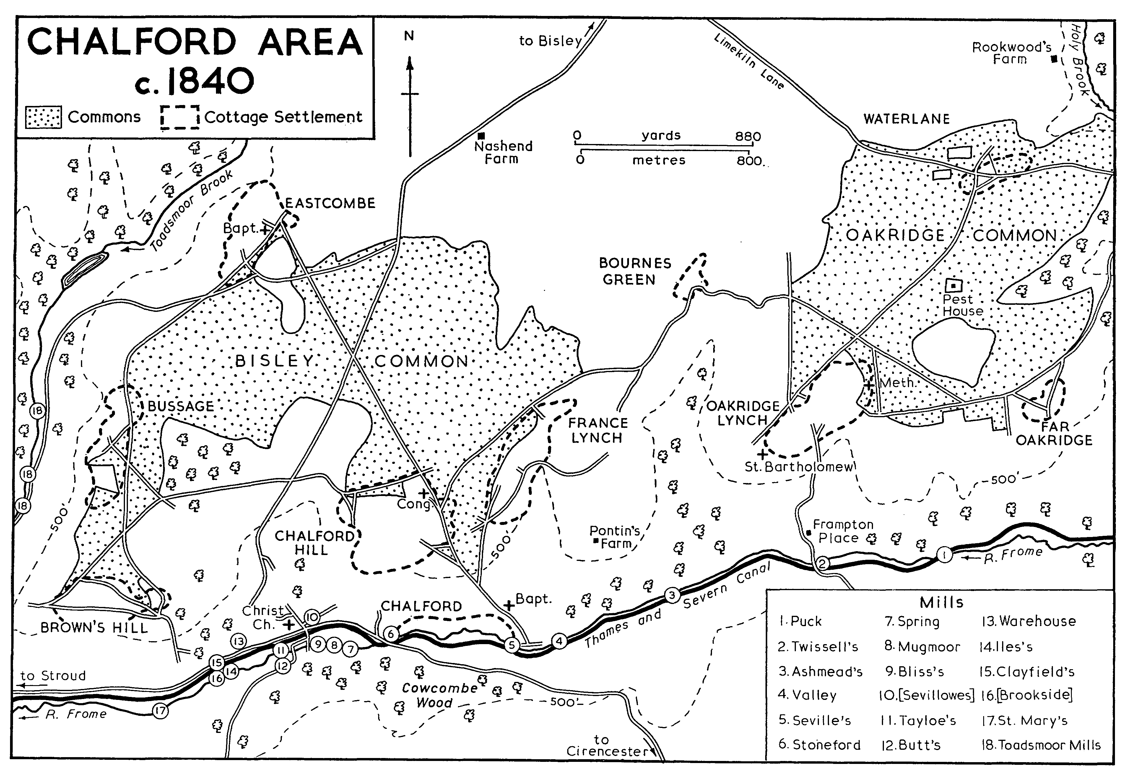
The boundaries of Bisley parish, which included 7,980 a., (fn. 1) were determined for the most part by streams running along deep valleys. (fn. 2) The southern boundary follows the river Frome, while most of the eastern is formed by the Holy brook, most of the western by the Toadsmoor brook, and most of the northern by a tributary of the Slad brook running down the valley formerly called Timbercombe in its upper part (fn. 3) and Driscombe in its lower. (fn. 4) The parish comprised 9 tithings, (fn. 5) of which 3 were geographically distinct units, each having a separate manor: Bidfield tithing, an area of 754 a., (fn. 6) lay north of the body of the parish, divided from it by an intervening strip of Miserden; Througham, distinguished by the deep coomb of a tributary of the Holy brook, occupied the north-east part of the body of the parish; and Tunley, also called Daneway, lay in the south-east corner on the far side of the Holy brook. The other six tithings were Steanbridge in the north-west, named from an important crossing of the Slad brook, Bisley comprising the primary settlement, Bussage (anciently Bisridge) (fn. 7) which took its name from the edge of the plateau in the south-west part of the parish, Chalford comprising the village of that name, Avenis (anciently Abbenesse) (fn. 8) on the high ground above Chalford where the villages of Chalford Hill and France Lynch developed, and Oakridge between Avenis and the Holy brook.
Bidfield tithing with a population of 31 was transferred to Miserden parish in 1884 when another detached part, containing 3 a. north of Bidfield, went to Cranham parish. Another small detached part, lying near Honeycombe Farm, was absorbed by Miserden in 1882 (fn. 9) when Bisley parish took in a small detached piece of Stroud lying by the bridge at Steanbridge. (fn. 10) In 1894 the southern and most populous part of Bisley with 2,980 inhabitants was formed into the new civil parish of Chalford and the remainder of Bisley, to which was added the northern part of Stroud with a population of 274, became the parish of Bisley-with-Lypiatt. (fn. 11) In 1936 the enlargement of Stroud U.D. took in a part of Bisley-with-Lypiatt (fn. 12) and in 1958 307 a. on the west side of the parish including the hamlets of the Vatch and Elcombe were transferred to Painswick. (fn. 13) The account here printed relates to the ancient parish of Bisley as it existed before 1882, except that Chalford, where some of the houses and mills lay within Minchinhampton, is dealt with wholly in Bisley.
Most of the parish is formed by a plateau of flat or gently rolling country lying at 600-875 ft. above the steep-sided valleys of the boundary streams; the plateau is broken in several places by deep coombs, in particular that of the tributary of the Holy brook cutting diagonally across the north-east corner of the parish and that of a tributary of the Toadsmoor brook bisecting the western half. The valley bottoms lie on the Inferior Oolite which is overlaid by a band of fuller's earth, while the high ground is formed by the Great Oolite, which in the northern area of the parish has a base of Stonesfield Slate. (fn. 14)
Woodland has long been a dominant feature of the landscape. The earliest record found of Bisley is a charter of 896 concerning woodland there which belonged to an estate at Woodchester, (fn. 15) and there was woodland worth 20s. on Bisley manor in 1086. (fn. 16) In 1575 280 a. of woodland belonged in severalty to the lord of the manor; it lay in 12 woods of which the largest were Painter's Frith (later Ireland's Frith or Frith wood) lying near Tunley on the west side of the Holy brook, Timbercombe in the extreme north-west corner of the parish, Siccaridge wood north-east of the confluence of the Holy brook and the Frome, and Litteridge wood in the east central area of the parish. (fn. 17) In 1608 most of those 12 woods, together with others called Oakridge, Bussage, and 'Weekstie', were listed as the lord's woods but were open to commoning rights of the tenants; Oakridge, Bussage, and Weekstie were distinguished, however, by the additional right of the tenants to take wood there. (fn. 18) The three woods evidently represented the large areas which later became commons and which tradition stated had been given to the inhabitants by Roger Mortimer, earl of March. (fn. 19) In 1636, estimated at the widely differing acreages of c. 300 and 1,000, those areas were known as the custom wood. (fn. 20) In 1708 the manor court named the custom woods in which the inhabitants had common of pasture as Nashend wood (later Nashend or Bisley common) which lay in the south-western area of the parish and evidently comprised the wood formerly called Bussage; Oakridge wood (later Oakridge common) in the south-eastern area; and in the north-west corner, evidently in the area formerly called Weeksite, Nottingham wood (later Nottingham Scrubs) and Plaisters (apparently that later called Custom Scrubs). (fn. 21) In 1730 the court put it on record that the areas of the parish called commons had previously been called custom woods (fn. 22) and presumably by then they had been largely cleared of trees; by the 1780s there remained only a tradition that Bisley and Oakridge commons, which together extended to 700 a., had once been covered with beech wood. (fn. 23) The 4 large commons and various small parcels of common were inclosed by Act of Parliament in 1869. (fn. 24)
The twelve woods recorded in 1575 generally remained several woodland, although most became divorced from the manor estate, which retained only Timbercombe and two of the smaller woods in 1636. (fn. 25) Litteridge wood, which covered over 50 a., became part of the Over Court estate in 1735 (fn. 26) and Calfway wood, covering 18 a. north of Bisley village, was part of the same estate from 1629. (fn. 27) Siccaridge wood, covering 60 a., was bought by Sir William Master of Cirencester in 1646 and usually remained in that family until 1846 when it was bought by Earl Bathurst. (fn. 28) In 1867 the Bathursts also added to the Cirencester Park estate two woods further east, Dorvel wood (in Sapperton parish) and Hen wood. (fn. 29) The latter was recorded as one of the woods on the Daneway manor estate from the mid 16th century. (fn. 30) Ireland's Frith and Hillhouse wood covering over 80 a. descended with the Hill house estate from the early 17th century, (fn. 31) and 65 a. of woodland, including Beech wood, belonged to the Bidfield manor estate in 1753. (fn. 32) The whole 280 a. mentioned in 1575 were entirely set with beech, with the exception of Siccaridge wood which also had some hazel, willow, and ash, (fn. 33) and beech has predominated in the parish. Thick woodland remained in 1972 on the steep hillsides, notably in the north-west corner of the parish and in the Golden Valley in the south-east part, which had acquired its name by the late 18th century, (fn. 34) either from its autumn hues or from the prosperity of the local cloth-mills.
The most important ancient route through the parish was that linking Painswick and Cirencester. It entered from the west by the bridge at Steanbridge, ran by Catswood Lane to Bisley village, by Limekiln Lane to Tunley, and left the parish at a crossing-point of the Frome, where the Henwood bridge recorded in 1600 (fn. 35) was possibly situated but where there was later only a ford. Its subsequent course is recalled by the name Bisley Path applied to one of the rides through Cirencester Park. Although it was never turnpiked, at some time milestones were placed along its course through Bisley parish. (fn. 36) Described as the highway from Bisley to Cirencester in its eastern part in 1756, (fn. 37) it apparently remained an important route until the early 19th century when largely superseded by new turnpike roads.
At Stancombe north-west of Bisley village the Painswick-Cirencester road was joined by the road from Stroud, which was turnpiked in 1823. (fn. 38) The junction was named as Stancombe Cross in 1777, (fn. 39) perhaps merely from the cross-roads formed there but possibly from the shaft of a Saxon cross, which is thought to have stood there before being set up as a parish boundary-stone further south. (fn. 40) Another road of some importance, known in its northern part as the Calf Way, (fn. 41) carried traffic from Tetbury and Minchinhampton through Bisley towards Birdlip. The northern part of the road was mentioned as the great road at Southmead in the early 13th century (fn. 42) and its southern part was evidently the way from Bisley to the house of William of Chalford recorded at the same period. (fn. 43) It still crossed the Frome at Chalford by a ford in 1608. (fn. 44) It was turnpiked between Chalford and Foston's Ash, north of Bidfield, in 1800, (fn. 45) and perhaps the easier course up the side of the Chalford valley was substituted then. A more recent route of importance in the parish is the Stroud-Cirencester turnpike built along Chalford Bottom in 1814. (fn. 46)
The streams on the boundaries of the parish were crossed in several places by lesser tracks, almost all of which, owing to their steepness, went out of use with the advent of motor transport. There were two ancient crossings at Chalford apart from the ford from which the village was named: Stoneford, recorded from the later 12th century, was the crossing-point of a track up Cowcombe hill on the line of the later Cirencester turnpike (fn. 47) and by 1413 another track crossed into Minchinhampton by Stephen's bridge at Valley Corner. (fn. 48) Rew bridge, recorded in 1608, was apparently that just above the confluence of the Frome and the Holy brook which carried a track from Oakridge into Sapperton parish. (fn. 49) William atte Rouwbrugge mentioned in 1355 (fn. 50) may have lived near by or else near the bridge called Row bridge in 1608, which carried a track from Bussage to Nether Lypiatt just above the mills at Toadsmoor. (fn. 51) Higher up the Toadsmoor brook another ancient track crossed into Upper Lypiatt by Bismore bridge (fn. 52) and, on the other side of the parish, Chelmead bridge mentioned in 1608 apparently carried the track which crosses the Holy brook into Edgeworth, having branches from Througham and Bisley village. (fn. 53) The track from Througham to Miserden, crossing the Holy brook further north, was recorded in the early 13th century. (fn. 54)
The Thames and Severn canal, opened fully in 1789 and abandoned finally in 1933, (fn. 55) runs through the Chalford valley at the south boundary of the parish; there was a wharf just south of Chalford church, (fn. 56) where one of the circular watchmen's cottages built in 1790 (fn. 57) survives. The Great Western railway line built along the valley beside the canal was opened in 1845. (fn. 58) A station was opened in Chalford village in 1897 (fn. 59) and there was also a halt west of the village at St. Mary's Mill; both were closed in 1964. (fn. 60)
The village of Bisley grew up at the cross-roads of the two most important roads through the parish, from Painswick to Cirencester and from Chalford to Birdlip. The main street, called High Street, developed along the latter road south of the cross-roads and along George Street (named from the inn which had opened opposite its eastern end by 1822) (fn. 61) which runs westwards from High Street. The church, founded by the 11th century, (fn. 62) is situated west of High Street and south of George Street, and the two former manor-houses of Over Court and Jaynes Court stand west of the church. (fn. 63) The village pound was situated at the west end of George Street (fn. 64) and near by there survives the village lock-up, or blind-house, a twin-celled building with an ogee gable, built in 1824 to replace an earlier blind-house which adjoined the churchyard. (fn. 65) The Bear inn, also at the west end of George Street, was recorded from 1631 (fn. 66) but is said to have been originally housed in a building on the other side of the street; (fn. 67) the inn has 17th-century columns supporting its upper floor. The manor court met at the Bear from 1766 until 1838. (fn. 68) The village consists almost entirely of stone houses and cottages of the 17th and early 18th centuries, in the traditional vernacular style. There is one jettied timber-framed building on the east side of High Street, the remains of a larger medieval house; it had a north wing, which was apparently remodelled in 1682 (fn. 69) but later was mostly removed. Among the later houses are Mount Pleasant Buildings, a row of 11 cottages stepped up the hill, built in 1823 by Thomas Goodlake, owner of the rectory estate. (fn. 70)
On Wells Road, leading south-westwards from High Street and named from the village wells, which were given a new well-head with 7 spouts in 1863, (fn. 71) stands the Mansion House, a large early18th-century residence with symmetrical elevations. It was enlarged in similar style within the same period, (fn. 72) and there are early-19th-century additions on the north-east, and some 20th-century internal remodelling. The keystones of the upper windows are carried up into the cornice, a local feature which is repeated on two other houses of similar date, Newell House and Rectory Farm, as well as on the additions made at the same period to Over Court and Jaynes Court. The Chantry, south-west of the Mansion House, occupies the site of the dwelling of the chantry priest; it was leased by the Crown to members of the Boughton family in the later 16th century (fn. 73) and in the mid 18th it belonged to Richard Butler, (fn. 74) later becoming part of the Lypiatt Park estate. (fn. 75) The substantial late-17th-century house was extended to the south and internally remodelled in the late 19th century. (fn. 76)
At Througham in the north-east part of the parish, formerly known alternatively as Druffham, (fn. 77) a settlement existed by the 11th century. The hamlet is formed by three large houses and a few cottages; one of the houses, Upper Througham Farm, is the former manor-house and another, Througham Court (formerly Lower Througham Farm), was the centre of a substantial freehold estate. The third house, called Manor House, belonged to the Lower Througham estate in the 19th century. (fn. 78) It is an early-18th-century farmhouse which was extended to the west later in the same century; a wing was added to the south side in the 19th century. During restoration c. 1935 the south wing was removed and the kitchen end remodelled. (fn. 79)
The deep coomb formed by the stream which was the boundary between Througham and Bisley manors was evidently the area known anciently as Cliveshale. A number of people surnamed of Cliveshale were recorded at Througham in the mid 13th century. (fn. 80) In 1477 Thomas Clissale was disputing a considerable estate there (fn. 81) and Richard Clissale, holding a capital messuage, was one of several free tenants of Cirencester Abbey at Cliveshale in 1540. (fn. 82) A family called Clissold, whose name is evidently of the same derivation, (fn. 83) still lived in Througham in the 18th century. (fn. 84) Their estate was possibly centred on the house called Througham Slad (fn. 85) standing on the north side of the coomb; in the 19th century it belonged in turn to the rectory and Lypiatt Park estates. (fn. 86) Its south range probably dates from the 16th century but has a late medieval window reset in the west gable. The house was extended and heightened in the 17th century, and in 1931, during restoration by Norman Jewson for W. A. Cadbury, dairies and a barn adjoining it on the north were incorporated into the house and a porch added. (fn. 87) In the valley below Througham Slad formerly stood a gabled house called the Greys; (fn. 88) it descended with the Upper Througham estate from the early 18th century (fn. 89) but was demolished by Sir John Dorington soon after 1883. (fn. 90)
Steanbridge tithing in the north-west part of the parish had a number of ancient farmsteads. In the extreme west end of the tithing is the house formerly called King's Place (fn. 91) but later called Furners Farm after the family that held it by copy in the 16th century (fn. 92) and as a freehold in the early 18th. (fn. 93) It retains a traditional plan and is apparently of the 16th century but it was partly rebuilt and enlarged to the west in the 17th century and again enlarged, to the south, in the late 19th. Catswood Farm further east is a tall 17th-century farm-house with later but nearly contemporary extensions to the north; the 17th-century gateposts at the entrance to the drive were possibly once part of a formal landscaped approach to the house. It was owned in the earlier 18th century by Thomas Rogers (fn. 94) (d. 1759) (fn. 95) and in 1770 by Nathaniel Rogers. (fn. 96) Ansteads Farm near was by recorded from the 14th century (fn. 97) but the present house is a small farmhouse of the 18th century. Sydenham's Farm, which stands at the head of a deep wooded valley, belonged in 1608 to Thomas Smart who claimed to hold by a charter of 1377 or 1378; (fn. 98) in the 18th century members of the Seville family owned it. (fn. 99) Originally a small house of c. 1600, it was enlarged to the south-west in the early 17th century and restored in the early 20th when the older range was extended to the north-west. A few farm-houses and cottages of no great antiquity and a turnpike house (fn. 100) stand by the Stancombe cross-roads; there was, however, a dwelling in that area by 1327 when William and Richard of Stancombe were recorded in the parish. (fn. 101) North-east of Bisley village there are 17th-century farm-houses at Calfway Farm and Derretts Farm.
A scattered group of dwellings, which became part of the Over Lypiatt manor estate, stood west of Bisley village. A house called the Pere on the hillside opposite Lypiatt Park (fn. 102) was held by William de la Pere in the mid 13th century. In 1620 it was bought by Edward Stephens of Over Lypiatt. The house still existed at the beginning of the 18th century (fn. 103) but was later demolished. There was probably also a house on the site of the near-by Copsegrove Farm by the mid 13th century when William de Coppithegrove had land in the area (fn. 104) but later there were two houses called Copsegrove. That at Copsegrove Farm originally belonged to Bisley manor and was alienated by the marquess of Buckingham in 1621. It was bought by Thomas Stephens in 1669 (fn. 105) and, with the exception of a short period in the early 19th century, remained part of the Lypiatt Park estate until 1919. (fn. 106) The house dates from the late 18th century and has a 20th-century addition in the vernacular style. Another house called Copsegrove together with a house called Colliers, a name preserved in Collier's Plantation, was granted by copy from Bisley manor to Gillian Wye of Over Lypiatt in 1581 (fn. 107) and Edward Stephens bought the freehold in 1621; both houses were derelict or had been demolished by the early 18th century. (fn. 108) Over Lypiatt manor also included a house at Nashend on the south side of the tributary of the Toadsmoor brook in 1530, (fn. 109) one of several houses there by the end of the 16th century. (fn. 110)
In the extreme north-western part of the parish the commons of Custom Scrubs and Nottingham Scrubs were sparsely settled with cottages; eight were recorded in 1801. (fn. 111) The largest group, called Piedmont by 1756, (fn. 112) was formed on the steep wooded hillside at the southern edge of Custom Scrubs and includes a few which date from at least the early 18th century. The establishment of a group of cottages further south, at Elcombe on the boundary with Stroud, had begun by 1734. (fn. 113)
On the southern boundary of the parish the growth of the village of Chalford, based on mills on the Frome, had begun by the late 12th century. (fn. 114) By the mid 13th century a mill and probably also the house called Chalford Place had been built at the ford from which the village was named, (fn. 115) and the establishment of other mills along the valley bottom produced a long straggling settlement. Although the chapel built to serve Chalford in the 1720s (fn. 116) was sited near the old ford, most of the cottages were concentrated along the valley road in the east part of the settlement, the area called Rack Hill from the common rack-hills which lay along the hillside above until 1869. (fn. 117) The valley road there was mainly developed in the late 17th and early 18th centuries, and from the later 18th century, when the valley bottom offered no further sites, cottages were built on the hillsides above, on such steep gradients that, as was noted in the 1770s, 'you ascend to the lowest storey, and descend to the highest'. (fn. 118) The distinctive character thus given to the village appealed to the taste of a slightly later generation of visitors, one of whom described it as 'a very Alpine hamlet'. (fn. 119)
Chalford Area c. 1840
The more ancient houses at Chalford, built by the clothiers among the mills on the valley floor, are described below. Other large houses built or rebuilt by millowners in the early 19th century stand along the lower slopes. Grove House, at the bottom of the steep lane up Marle hill, was rebuilt as a Regencystyle villa in the early 19th century. It was owned in the 18th century by the Blackwell family of clothiers, (fn. 120) of whom Archer Blackwell was recorded in 1715 (fn. 121) and John Blackwell died c. 1772; John's son Archer (fn. 122) sold the house, then known as the Blackhouse, to William Toghill in 1803, and it later passed to a silk-throwster John William Jones (d. 1860). (fn. 123) Wickham Grange, further west, was called Beaumont House in the late 19th century when it was the home of the stick-maker William Dangerfield (d. 1894). (fn. 124) It is a substantial late-18thcentury house to which a semicircular bay was added on one side of the main front in the 19th century; in the 20th century an extension was made to the east to house a printing-works. Skaiteshill House, a tall early-19th-century house on the road from Chalford to Brown's Hill, belonged to Charles Ballinger in 1842 but was occupied by John Ballinger (fn. 125) (d. 1848), his brother; it was later the home of John's eldest son Charles (d. 1884). (fn. 126) Millswood by the Chalford-Bisley road was occupied by the clothier John Trotman (d. 1802) and in the 1840s by a silk-throwster Samuel Hook. (fn. 127) Springfield House, at the foot of Cowcombe hill by the Stroud-Cirencester road, belonged to the clothiers Handy and Jesse Davis in 1838 when it was described as newly erected. (fn. 128)
The high ground of the southern half of the parish, which was only sparsely settled in ancient times, was later rendered the most populous area by squatter development by weavers and other cloth-workers on the fringes of Bisley and Oakridge commons. The cottages were usually built on the higher slopes just below the rim of the central plateau and to several groups the name 'lynch' meaning a ridge (fn. 129) was applied. That development produced the five substantial villages of Eastcombe, Bussage, Chalford Hill (or Chalford Lynch), France Lynch, and Oakridge Lynch, and the smaller hamlets of Brown's Hill, Bournes Green, Oakridge (or Far Oakridge), and Waterlane. The settlement of those areas had evidently begun by c. 1710 when the parish was said to have an abundance of poor cottages (fn. 130) and c. 1775 there were said to be several populous villages on the commons, inhabited chiefly by poor people employed in the cloth trade. (fn. 131) Development continued into the 19th century; c. 1810 it was estimated that 120 cottages had been built on the commons in the previous 17 years. (fn. 132) Long fingers of common which remained, snaking in between the cottages, (fn. 133) were largely taken in as gardens at the inclosure of 1869, (fn. 134) leaving a network of narrow paths. The cottages, which stand at all angles to meet the uneveness of the ground, mostly date from the 18th century, the vernacular style with its mullioned windows evidently surviving late into that century. There are a few cottages of the later 19th century, including 2 pairs of Gothic model cottages at Eastcombe, and the villages also have some 20th-century development, particularly Eastcombe and Chalford Hill.
Before the development of the villages there were a few scattered farms around the edges of the commons. Habitations were recorded at Bussage from the mid 13th century (fn. 135) and at Eastcombe from 1571, (fn. 136) and a house at Brown's Hill, called Stonehing in 1732, (fn. 137) probably existed by 1351 when Reynold Stonhenge was recorded in the parish. (fn. 138) A house with assart land was mentioned at Avenis in the mid 13th century (fn. 139) and three or four dwellings were established in the woodland in that area in the early Middle Ages. (fn. 140) Solomans Court Farm at Avenis was apparently the house called Salmons held by copy from Over Lypiatt manor in 1526, (fn. 141) for in 1594 the lord of the manor sold the freehold of Solomans Court to Henry Restall. (fn. 142) It is a farm-house of the earlier 17th century, which was partly refitted in the 18th and remodelled and enlarged in the 20th. Pontin's Farm (formerly Sturmyes Court) further south is evidently also a site of some antiquity, (fn. 143) although the house is no older than the 18th century. Iles's Farm at Far Oakridge, perhaps the home of Thomas Iles of Oakridge (d. 1714), (fn. 144) is an early17th-century farm-house which had some additions to the west end in the 18th century. In 1914 it was much enlarged to the north and restored by Norman Jewson as the residence of the painter Sir William Rothenstein (fn. 145) (d. 1945). (fn. 146) Frampton Place south of Oakridge Lynch was recorded from 1550 (fn. 147) and at Trillis near the confluence of the Frome and the Holy brook, where the house had been demolished by 1972, a habitation was mentioned in 1538. (fn. 148)
At Waterlane there was a house on the site of Watercombe House by 1621 when Samuel Tocknell bought the freehold from the lord of Bisley manor. (fn. 149) The house was rebuilt in the early 19th century by its owner, the amateur architect Thomas Baker, (fn. 150) who extended it further to the south in 1833. (fn. 151) A small building in the garden was built to house the materials from a Roman villa at Lillyhorn, near Bournes Green, excavated by Baker in 1846, and incorporates bricks and tiles from the site. (fn. 152) Waterlane House near by was also designed by Baker (fn. 153) but was enlarged in 1907-8 for F. F. McMeekan by Ernest Gimson who added gables and fenestration in the vernacular style. (fn. 154) Rookwood's Farm to the north-east of Waterlane is an ancient site. (fn. 155)
The tithing of Tunley has a few isolated farmsteads, including the ancient manor-house, called Daneway House, and Hillhouse Farm which is also of medieval origin. (fn. 156) In the north of the tithing two farm-houses standing by the old Cirencester road were formerly part of the Daneway manor estate. King's House, recorded from 1729, remained part of the estate (fn. 157) until 1867 when it was sold with 173 a. to a timber-merchant, but it was reunited with Daneway by Earl Bathrust in 1907. (fn. 158) Tunley Farm, was left by Thomas Hancox of Daneway at his death in 1792 to a younger son Thomas; (fn. 159) in 1842 with 141 a. it was the property of John Hancox, (fn. 160) passing before 1860 to his son Henry William Hancox. (fn. 161) The house had been demolished by 1972 leaving substantial farm buildings. There was very little cottage development in the tithing; of a group of five which stood on the road south-east of King's House in 1867 (fn. 162) only one survived in 1972.
The detached tithing of Bidfield was sparsely settled. Only four people were assessed for tax there in 1327 (fn. 163) and in 1381 it was said to be uninhabited. (fn. 164) Apart from the two ancient houses of Bidfield Farm and Hazle House, (fn. 165) the tithing had little habitation until the establishment of the Whiteway Colony. The colony was founded in 1898 by a small group associated with the Croydon Brotherhood Church and influenced by the teaching of Tolstoy. They acquired a small house and 42 a. in the east part of Bidfield and planned to practise communal subsistence farming, but within a few years were forced to compromise on some of their ideals, allowing the working of plots of land individually and living partly by the sale of produce and by occasional work for local farmers. From the 1920s there were also some colonists who practised crafts. Legal ownership of land and the institution of any formal organization for governing the colony were, however, long resisted, the latter coming only in 1934. By then over 100 people lived in the colony in a collection of small wooden houses. (fn. 166) In the early 1970s, when there were over 60 small dwellings, occupied mainly by people employed in the neighbouring towns, few vestiges of the original concept remained. A monthly colony meeting still met, however, to admit new owners of houses to the use occupation of the land on which they stood and to deal with matters such as the upkeep of the roads of the colony. (fn. 167)
In 1327 47 people were assessed for the subsidy under Bisley, 8 under Througham, and 4 under Bidfield. (fn. 168) In 1381 64 were assessed for poll-tax under Bisley and 32 under Througham. (fn. 169) At both dates the inhabitants of Tunley were listed under Over Lypiatt, of which it was a sub-manor. (fn. 170) Estimates of 628 communicants in the parish in 1548 (fn. 171) and c. 400 in 1551 (fn. 172) largely invalidate each other. An estimate of 112 households was made in 1563, (fn. 173) and in 1650 there were said to be 300 families. (fn. 174) The burgeoning population in the south of the parish is reflected in estimates of c. 3,200 people in 710 houses c. 1710 (fn. 175) and of c. 4,900 people c. 1775, (fn. 176) although the second is shown to be an overestimate by the figure of 4,227 people (in 922 houses) returned in 1801. The population continued to rise in the early 19th century reaching 5,896 in 1,264 houses by 1831 but by 1841 depopulation due to the decline in the Chalford cloth industry was reflected in a fall in population to 5,339 and in the 176 houses standing empty. The decline continued to 4,692 in 1861 but there was subsequently some recovery to 5,171 in 1891. The severance of the Chalford region in 1894 reduced the population by more than half and Bisley-with-Lypiatt had 2,071 people in 1901; its population was roughly maintained until 1921 but there was subsequently a gradual fall to 1,639 in 1961. The population of Chalford civil parish, 2,980 in 1901, also decreased after the 1920s, to 2,556 in 1961. (fn. 177)
The parish had several taverns at the end of 16th century, (fn. 178) and three alehouses were recorded in 1660; (fn. 179) there were 12 in 1781, (fn. 180) and in 1838 15 public houses and 35 beershops. (fn. 181) In Bisley village, apart from the Bear and the George mentioned above, there were the New Inn at the north end of the village, which was recorded from 1774 and in the mid 20th century became the Stirrup Cup; (fn. 182) the White Hart in Wells Road, which had opened by 1778; (fn. 183) the Bell at the south end of High Street, which was in existence by 1796 and until 1953 when it became the headquarters of the British Legion; (fn. 184) and the Red Lion adjoining Rectory Farm, which had opened by 1831. (fn. 185) The Crown inn where the manor court met in 1710 (fn. 186) and the Horseshoes at which the vestry met in 1782 (fn. 187) were presumably also in the village. In 1972 only the Bear and the Stirrup Cup remained.
In Chalford, apart from the Company's Arms and the Valley inn, both mentioned below, (fn. 188) the public houses recorded at an early date included the Red Lion, which had opened on the north side of the main village street by 1804; (fn. 189) the New Red Lion, on the south side of the street, which had joined it by 1831; (fn. 190) the Bell which had opened west of the New Red Lion by 1820; (fn. 191) the Greyhound recorded from 1820 at a house, since demolished, south of Bliss's Mill; (fn. 192) the Old House which stood west of Bliss's Mill and was demolished and replaced by cottages after 1872; (fn. 193) and the Carpenters' Arms which had opened by 1856 (fn. 194) on the Stroud road west of the village. The New Red Lion, the Carpenter's Arms, and the Valley inn survived in 1972. Chalford Hill had the Duke of York by 1831, (fn. 195) the Wheatsheaf on the west of the village by 1842, (fn. 196) and the Mechanic's Arms by 1856. (fn. 197) The Ram inn at Bussage had opened by 1831; (fn. 198) Tunley had the Labourer's Arms in 1854; (fn. 199) Brown's Hill had the Barley Mow in 1842; (fn. 200) and in 1856 France Lynch had the King's Head and the Court House, (fn. 201) Oakridge had the Nelson, and Oakridge Lynch had the Butcher's Arms. (fn. 202)
There were friendly societies in the parish with a total membership of 280 by 1815. (fn. 203) That earliest recorded was one meeting at the Bell in Bisley in 1797, and from the early 1860s until 1891 a benefit society met at the village school. A branch of the Society of Clothworkers was meeting at Chalford in 1805, and in 1869 there was the Chalford Friendly Society. A friendly society met at the Wheatsheaf at Chalford Hill in 1846; the Tunley Friendly Society was recorded in 1854; and Eastcombe had a society in the 1860s. (fn. 204) A building called the Court House, built by J. E. Dorington in 1865 on the east side of Bisley High Street, (fn. 205) contained a reading-room as well as a meeting-room for the local board of health. (fn. 206) By 1863 Chalford had a mutual improvement society which ran a readingroom and library. (fn. 207) Horse races were held at Bisley in 1740. (fn. 208) An annual August pleasure-fair called Chalford Feast was held in that village from at least 1856 (fn. 209) until the mid 20th century. (fn. 210)
The Bussage House of Mercy (later St. Michael's), a diocesan home for reformed prostitutes, was founded in 1851 by Robert Suckling, perpetual curate of Bussage, John Armstrong, vicar of Tidenham, and Mrs. Grace Poole of Brownshill House, who became superintendent of the home. (fn. 211) New buildings west of Brown's Hill were opened by 1855 when there were 20 inmates and the home was later supported in part by their needlework and laundry work. (fn. 212) On Mrs. Poole's death in 1900 the House of Mercy was taken over by the Wantage Sisters who maintained it until 1948. (fn. 213)
There was a small disturbance at Chalford in the depressed year of 1795 when some of the inhabitants stopped a barge-load of wheat on the canal, demanding that it should be sold locally at a reduced price; (fn. 214) and there were more serious incidents when riotous mobs assembled at some of the Chalford mills during the weavers' strike of 1825. (fn. 215) In 1896 a plan of the Stroud joint hospital board to house smallpox cases in the old parish pest-house at Oakridge angered local people who attacked and fired the building; the plan was abandoned and instead the board built an isolation hospital at the Wittantree near the Stancombe cross-roads. (fn. 216) The murder of the tenant of Frampton Place by his son in 1893 is said to have inspired John Masefield's poem 'No man takes the farm'. (fn. 217) The local legend of the 'Bisley Boy', which concerns the death of the infant Queen Elizabeth I at Bisley and the substitution of a boy child, has gained wide currency. (fn. 218)