Survey of London: Volume 23, Lambeth: South Bank and Vauxhall. Originally published by London County Council, London, 1951.
This free content was digitised by double rekeying. All rights reserved.
'The County Hall', in Survey of London: Volume 23, Lambeth: South Bank and Vauxhall, (London, 1951) pp. 62-65. British History Online https://www.british-history.ac.uk/survey-london/vol23/pp62-65 [accessed 26 April 2024]
In this section
CHAPTER 16 - THE COUNTY HALL
[See plates 40, 41 and 42.]
The main block of County Hall occupies the site of part of Float Mead and the whole of Pedlar's Acre, Bishop's Acre and the Four Acres (see p.45).
(i)Float Mead. In 1731 the Westminster Bridge Commissioners purchased from the Archbishop a detached part of Float Mead near Stangate, which, like ground between Jesus College Estate and Cuper's Bridge, was on lease to Gilbert East. Having used as much as they needed to form the bridge approach, they in 1747 sold the ground on the north side to Robert Andrews of St. George's, Hanover Square, for £1820. (fn. 74) Andrews resold it a few days later to Roger Morris, (fn. 74) master carpenter of the Office of Ordnance, who was also a speculative builder. Seven houses were erected on the street frontage—Nos. 1–7 Bridge Street, later Nos. 268–280 (even) Westminster Bridge Road (Plate 49). Shop fronts were inserted at an early date and No. 280 was for many years known as the Coronet public house.
The ground behind the Bridge Street houses was in 1747 occupied by a wharf (later Burnham's wharf) and some sheds. Simmond's flour mills covered the greater part of the site during the latter part of the 19th century. John Whately Simmonds bought the whole of the site from the Morris family in 1881 (fn. 74) for £38,000 and sold it to the London County Council in 1906 for £90,000. (fn. 74)
(ii) Pedlar's Acre. The origin of the name Pedlar's Acre for this piece of ground is a matter for conjecture. It first occurs, without explanation, in a lease of 1690, (fn. 139) previously having been entered in the Lambeth churchwardens' accounts as the Church or Osier Hope. (fn. 100) The name of the donor had been forgotten before 1639, for in that year a payment was made for searching the rolls “concerning the Church Hoopes.” (fn. 100) The picture in painted glass of a Pedlar and his Dog which used to be in the parish church of St. Mary, Lambeth, has been connected by tradition with this ground and several mutually contradictory legends have grown up round it. From the churchwardens' accounts it is clear that a similar window existed as early as 1607, when 2s. was paid “for a pannell of glase for the windo where the picture of the pedler standes” (fn. 100) (see. p. 104). At the end of the 15th century and beginning of the 16th a family with the surname Palmer gave a number of donations to the church and it is probable that the window was a rebus on their name and that, the origin of the church ownership of the Osier Hopes having been lost, the window, and the benefactors it commemorated, and the acre of ground became linked together in the minds of the parishioners.
The steady rise in the value of the land can be traced in the accounts, e.g. in 1504 it was let for 2s. 8d. a year, in 1557 for 5s., in 1623 for 26s. 8d., and in 1656 for £4. The increased value was partly due to the devaluation of money and partly to the increased usefulness of the land.
In 1810 the southern part of Pedlar's Acre was let to Henry Maudslay, and the firm of Maudslay, Sons and Field, general engineers, remained there until the land reverted to the Lambeth Borough Council in 1900. (fn. 140) Among many other things made there were a pumping engine for the Lambeth Waterworks (1831) and the “Lord William Bentinck,” said to have been the first iron vessel built on the Thames (launched in 1832). (fn. 140)
Two wharves and houses, known as Nos. 7 and 9 Belvedere Road, were built on the northern portion of the land. As the ground was not known to have been given for purely ecclesiastical uses its revenue was taken by Lambeth Vestry and subsequently by the Metropolitan Borough of Lambeth. It was sold to the County Council in 1910 for £81,342, having for the previous few years been used as a depot by the borough council. (fn. 74) The boundary stone illustrated here was found during the excavations for the foundations of County Hall. It measures four feet five inches by one foot eleven inches by one foot seven inches.
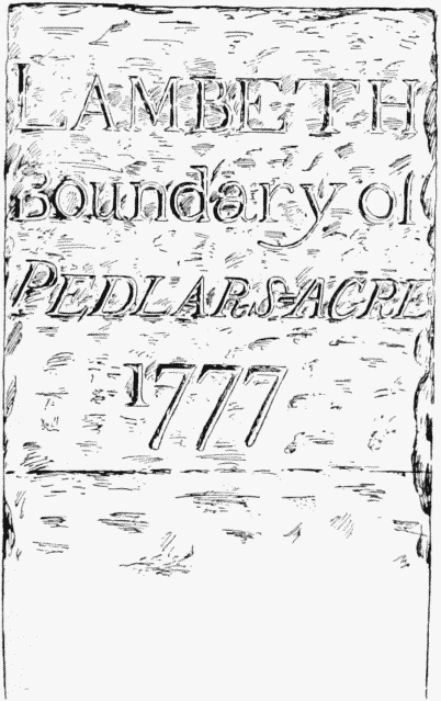
Boundary stone of Pedlar's Acre
(iii)Bishop's Acre. This ground was presumably so named because it belonged to the Archbishop of Canterbury. It was described in a lease of 1718 as a “parcel of meadow of ozier ground lately made a wharf and in parts divided bya dock or docks,” (fn. 141) a description which was repeated in subsequent leases throughout the 18th century. When the ground was bought by the London County Council in 1908 it was occupied by Messrs. Crosse and Blackwell's factory. (fn. 142)
(iv) The Four Acres. Until the erection of County Hall this ground was divided into two by a draw dock which extended back as far as Belvedere Road. The whole property was leased in 1802 to William Adam, architect, who used it for workshops and stables until he was declared a bankrupt, after which the lease was assigned to Robert Forrest, timber merchant. (fn. 143) The London County Council acquired the northern part of the ground in 1894 for its Works Department (subsequently used as a Tramways Office), (fn. 74) Messrs. Holloway, who were in possession of the southern part, strongly opposed the Council's bill for compulsory purchase of their site in 1906, but were overruled. (fn. 142)
The Erection of County Hall
When the London County Council succeeded the Metropolitan Board of Works in 1889 the office accommodation comprised the principal office facing St. James's Park and Nos. 10, 12, and 14 Spring Gardens. It was even then inadequate and the increasing functions of the Council soon made the acquisition of more accommodation a necessity, Suggestions for acquiring sites in Parliament Street, Trafalgar Square, or the Adelphi were rejected. In 1905 the Council decided to acquire the riverside site north of Westminster Bridge and in the following year obtained parliamentary powers to do so. (fn. 142)
The design of the new building was made the subject of a public competition for which 99 entries were submitted at the first stage. The design of Ralph Knott was finally accepted, though with some modifications.
The Act (fn. 144) included permission to enclose 2½ acres from the foreshore and construct a new river wall. This work was begun in 1909 and finished in 1917.
The Roman Boat. The Roman boat found in 1910 during the excavations for the concrete raft on which County Hall is built, excited much interest. Parts of the timbers were destroyed before their presence was recognized, but what was left of the boat was carefully lifted, treated with preservative and deposited in the London Museum. At the time she was thought to have been a Roman galley, and from the evidence of three coins found in her was dated at about the year A.D. 300. One theory was that she went down in a fight between Allectus and Constantius in the year A.D. 296, and the large round stone embedded in her timbers, which might have been ammunition thrown from a Roman ballista, lent colour to this assumption. (fn. 145)
More recently experts in nautical research have considered that her timbers were too lightly jointed for a sea-going vessel and that it was unlikely that she ever possessed a mast. It seems probable that she was a ferry boat plying across the river and that she became derelict in her old age or was sunk by accident. There was a large hole in her bottom and she may have met her end by drifting on to her mooring post in a high tide. This type of vessel would have been much shallower in draft than a galley and much shorter in proportion to her width. She could have been propelled by one man rowing her standing as is still done on vessels of this type. If, as is suggested on p. I, a Roman road from Canterbury crossed the river to Westminster from a point between Westminster and Lambeth Bridges, then this may have been one of the boats employed at the crossing; this is, however, conjecture. Her timbers had been repaired in a number of places, showing that she was an old boat when she met her end. A varied collection of pottery and other objects were found in and around her, most of which have been preserved.
Work on the erection of County Hall ceased in 1916 owing to the war, but was resumed in 1919, and the building was opened on 17th July, 1922, though the northern section was not completed until 1933. (fn. 146) It soon became apparent that with the expansion of departments caused by the imposition of additional duties upon the Council the accommodation of the building had become inadequate. This need was met by the erection of two office blocks fronting York Road; they were built under the direction of the Architect to the Council, F. R. Hiorns, in association with his predecessor E. P. Wheeler, while Sir Giles Gilbert Scott acted as consulting architect. Both blocks have yet to be completed.
Architectural Description
The accommodation of the County Hall is planned round a number of internal courtyards with the council chamber placed at the heart of the building. The enclosing blocks form an approximate rectangle whose slightly tapering long sides face westwards to the river and eastwards to Belvedere Road. The monotony of a continuous river facade is relieved by the broad sweep of the colonnaded crescent with its pavilion terminations and central fleche, while in the middle of the Belvedere Road front an imposing feature is made of the ceremonial entrance.
Like the east and west elevations, the south front overlooking Westminster Bridge Road is flanked by pavilion terminations; it has a central arched entrance leading through a vaulted approach of Piranesian character to the members’ courtyard south of the council chamber. The north front, with its servicing entrances, is of less interest and is without end pavilions.
The County Hall is designed in a free Classic style and is faced with Portland stone except at the base where, like the river wall in front, it is finished in granite.
There are two basement storeys below road level, and above the first or principal floor used chiefly by members of the council there are five floors of offices. The fifth and sixth floors are in the roof above a heavy overhanging cornice, and are lighted on the outer elevations by dormer window set in the long roof slopes which are laid with rich red Italian tiles.
The figure sculpture above the heads of the pavilion windows on the principal floor was carved by Ernest Cole and Alfred Hardiman, while the architectural carving was executed by C. H. Mabey.
The office blocks fronting York Road are disposed on each side of the axial approach to the ceremonial entrance of the County Hall. They are linked by a bridge at first floor level and have the same number of storeys as the old building. The external finishes are similar, though the architectural detail is simpler.